Minutes of Meeting - Farmonaut and Chippy Pushpangathan

Her research topic is broadly centered around:
“Potential of Precision Agriculture Using Geospatial Information For Kharif Cultivation in Kalaburagi District, Karnataka, India”
This research work is funded by the Department of Science and Technology (DST, Govt. of India) under INSPIRE Scheme.
To read more in detail about the project and the collaboration please read the full article on the link below:
MINUTES OF MEETING
Usage of MODIS imagery in previous works
Chippy has downloaded and used modis images and has come to a conclusion that much can’t be done with these images because the spatial resolution of the images is 250 meters, hence, we can map vegetation only on district level or state level.
Requirement of previous years’ data for reference for the current study
Chippy does not have any field level data from 2018. National crop forecasting center gathers all the field level data (latitude longitude, crop cutting etc.), but they are hard to communicate with and they rarely reply to emails.
The premilinary data required is the Latitude, Longitude data for a few fields in Aland taluk in kalaburagi district for kharif season from june to December of 2018. Gulbarga kharif season crop does not exist much since the analysis done on 15 years of MODIS imagery revealed that fields during kharif season are severely drought affected.
Current Method of Accessing Satellite Imagery Data
Currently NRSC provides satellite imagery at around INR 4k-7k per tile (70kmx70km) with a resolution of around 5.4 meter for latest imagery. The pricing is less for older image requests. However, to access imagery it is required to request it from them every time through emails with a complete request form. Sometimes they don’t even consider providing satellite imagery and it is a very big hassle to get the imagery from them periodically.
Rough roadmap of the work
Before june 2019, Krishi vigyan Kendra will help Chippy get fields for the proposed study. All the study will be done on these fields. Chippy is planning to take taluk level fields, at least a minimum of 6 farms. Images will be taken from Farmonaut periodically for each stage of crop growth, simultaneously Chippy will work on her data as well. The suggested study will have at least two to three crops for separability.
Devices to be used for ground level analysis
Leaf area index meter, Chlorophyll meter, Temperature meter etc.
Macro Level Objective and Expectations
The objective will be to correlate the ground level data with satellite data and create a yield prediction model.
If any kind of change that happens in a farm field in a particular time, the objective will be to identify how it will affect the farm. For example, if too much rainfall happens then, the objective will be to predict what could possibly happen and how much it will affect the yield.
Farmonaut currently provides two satellite imagery based products, namely:
Satellite Based Crop Health Monitoring System For Farmers (Android):
Farmonaut provides satellite based crop health monitoring system, through which farmers can select their field and identify the regions of the field at which the crop growth is not normal. Upon identifying that region of their fields, they can simply pay a visit to that part of the field and identify if the problem has already started. If it has not, the farmer can take preventive remedies by applying more fertilizers, plant growth regulators etc. If the problem has already started, they can simply explain their problem to Farmonaut’s crop issue identification system and get real-time govt. approved remedies.

Satellite Imagery Access For Research System (Android and Website)
For research purposes (non-farming usage), Farmonaut provides access to satellite imagery of any place around the through our website and android app. The satellite imagery is provided at the cheapest market rates. Accessing satellite imagery through our website is a fairly simple process:
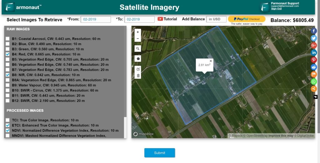
Step 1: Select the date range (From and To Date)
Step 2: Select Imagery bands required (You can select from 13 raw bands and 7 Farmonaut Processed bands)
Step 3: Select the area on the Map for which you are requesting the imagery for.
Step 4: Submit this request… wait for a few seconds
Step 5: Select specific days for which you need the imagery for.
Step 6: Make payment and voila!
You will receive the imagery automatically into your email address within the displayed time interval.
The app is available for android on Google PlayStore:
https://play.google.com/store/apps/details?id=com.farmonaut.android
We will keep posting about any such informative information on to our blogs, to help as many people as possible. Farmonaut is built upon a vision to bridge the technological gap between farmers and strives to bring state-of-the-art technologies in the hands of each and every farmer. For any queries/suggestions, please contact us at [email protected].
We have some more interesting articles coming up soon. Stay tuned!
Wait!!
Before that…
Follow us at:
Facebook: https://facebook.com/farmonaut
Instagram: https://instagram.com/farmonaut
Twitter: https://twitter.com/farmonaut
LinkedIn: https://www.linkedin.com/company/farmonaut/
Pinterest: https://in.pinterest.com/farmonaut/
Tumblr: https://farmonaut.tumblr.com/
Youtube: https://www.youtube.com/channel/UCYWOOPPKATLgh4L6YRlYFOQ
AppLink: https://play.google.com/store/apps/details?id=com.farmonaut.android
Website: https://farmonaut.com
Satellite Imagery: https://farmonaut.com/satellite-imagery
Satellite Imagery Samples: https://farmonaut.com/satellite-imagery-samples