Revolutionizing Agriculture: Godrej Agrovet’s Massive Field Mapping Initiative with Farmonaut®
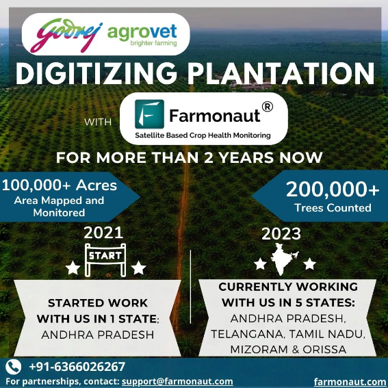
At Farmonaut®, we’re thrilled to share an exciting development in the world of precision agriculture. In a remarkable feat of efficiency and scale, Godrej Agrovet has successfully mapped over 1,00,000+ Acres of area and 2,00,000+ trees counted from our cutting-edge ecosystem of platforms. This achievement marks a significant milestone in our ongoing collaboration with Godrej Agrovet, aimed at revolutionizing farm management and crop monitoring practices.
Leveraging Farmonaut®’s Advanced Technology
Once the initial mapping phase is complete, the real power of our technology comes into play. The mapped fields will be integrated into Farmonaut®’s Satellite-Based Crop Health Monitoring System. This advanced system will provide continuous monitoring and analysis of various critical factors, including:
- Crop health
- Water stress levels
- Evapotranspiration rates
- Soil organic carbon content
- Localized weather forecasting
By harnessing the power of satellite technology and advanced analytics, we’re enabling Godrej Agrovet to gain unprecedented insights into the health and productivity of the mapped farmlands.
The Impact of Large-Scale Farm Monitoring
The collaboration between Godrej Agrovet and Farmonaut® represents a significant leap forward in the adoption of precision agriculture techniques at scale. Here’s why this project is so important:
- Data-Driven Decision Making: By collecting and analyzing vast amounts of farm-level data, Godrej Agrovet can make more informed decisions about resource allocation, crop selection, and intervention strategies.
- Improved Crop Management: Real-time monitoring of crop health allows for early detection of issues such as pest infestations, nutrient deficiencies, or water stress, enabling timely interventions.
- Resource Optimization: With detailed insights into soil conditions and water stress levels, farmers can optimize their use of water, fertilizers, and other inputs, reducing waste and improving sustainability.
- Enhanced Productivity: By addressing potential issues early and optimizing resource use, farmers can significantly boost their crop yields and overall farm productivity.
- Climate Resilience: Access to accurate weather forecasting and soil data helps farmers adapt their practices to changing climate conditions, improving resilience in the face of unpredictable weather patterns.
The Power of Satellite-Based Crop Health Monitoring
At the heart of this initiative is Farmonaut®’s Satellite-Based Crop Health Monitoring System. This advanced technology offers several key advantages over traditional monitoring methods:
| Feature | Farmonaut® Satellite System | Drone-Based Monitoring | IoT-Based Monitoring |
|---|---|---|---|
| Coverage Area | Large scale (thousands of hectares) | Limited (few hectares per flight) | Limited to sensor placement |
| Frequency of Data Collection | Daily to weekly | As per manual flights | Continuous but localized |
| Cost-Effectiveness | High | Moderate | Low (high initial investment) |
| Ease of Deployment | No on-ground equipment needed | Requires skilled operators | Requires physical sensor installation |
| Data Consistency | High (standardized satellite data) | Moderate (affected by flight conditions) | High (but limited to sensor locations) |
As the table illustrates, our satellite-based system offers unparalleled coverage, consistency, and cost-effectiveness, making it the ideal choice for large-scale agricultural monitoring projects like the one undertaken by Godrej Agrovet.
Key Components of Farmonaut®’s Monitoring System
Let’s delve deeper into the critical elements of our Satellite-Based Crop Health Monitoring System that will be employed in this project:
1. Crop Health Assessment
Our system uses advanced multispectral imagery to analyze crop health at a cellular level. By measuring the reflection of light at different wavelengths, we can detect issues such as nutrient deficiencies, pest infestations, or disease outbreaks before they become visible to the naked eye. This early detection capability allows for prompt interventions, potentially saving entire crops from failure.
2. Water Stress Monitoring
Water management is crucial in agriculture, especially in regions prone to drought or with limited water resources. Our satellite-based monitoring system assess water stress levels across vast areas by analyzing vegetation indices and thermal data. This information helps farmers optimize irrigation schedules, reduce water waste, and ensure crops receive adequate hydration throughout their growth cycle.
3. Evapotranspiration Analysis
Evapotranspiration (ET) – the sum of evaporation from the land surface and transpiration from plants – is a critical factor in understanding crop water requirements. By measuring ET rates, our system provides valuable insights into crop water consumption, helping farmers fine-tune their irrigation strategies for maximum efficiency.
4. Soil Organic Carbon Mapping
Soil organic carbon (SOC) is a key indicator of soil health and fertility. Our advanced satellite imagery and machine learning algorithms can estimate SOC levels across large areas, providing a comprehensive view of soil quality. This information is invaluable for developing targeted soil management strategies, improving crop yields, and promoting sustainable farming practices.
5. Weather Forecasting
Accurate, localized weather forecasting is essential for effective farm management. Our system integrates data from multiple sources, including satellites and ground-based weather stations, to provide highly accurate short-term and long-term weather predictions. This helps farmers plan their activities, from planting and harvesting to pest control and irrigation, with greater precision.
The Farmonaut® Advantage: Accessible Precision Agriculture
What sets Farmonaut® apart in the world of agricultural technology is our commitment to making precision agriculture accessible to farmers of all scales. Here’s how we’re achieving this:
- User-Friendly Platforms: Our web and mobile applications are designed with the end-user in mind, making it easy for farmers and agronomists to access and interpret complex data.
- Affordable Solutions: By leveraging satellite technology, we eliminate the need for expensive on-ground sensors or frequent drone flights, making our services cost-effective for large and small operations alike.
- Scalability: Whether you’re managing a small family farm or overseeing vast agricultural enterprises like Godrej Agrovet, our systems can scale to meet your needs.
- Integrated Approach: We don’t just provide data; we offer actionable insights that integrate seamlessly with existing farm management practices.
- Continuous Innovation: Our team of agronomists, data scientists, and software engineers are constantly refining our algorithms and expanding our capabilities to stay at the forefront of agricultural technology.
To experience the power of Farmonaut®’s technology firsthand, we invite you to explore our platforms:
- Download our mobile app:
Android |
iOS - Access our web application: Farmonaut Web App
- For developers interested in integrating our data into their own solutions, check out our
API documentation and
Satellite Weather API docs
The Future of Agriculture: Data-Driven and Sustainable
Projects like the one undertaken by Godrej Agrovet in collaboration with Farmonaut® represent the future of agriculture. By harnessing the power of satellite technology, advanced analytics, and machine learning, we’re ushering in a new era of precision farming that promises to:
- Increase crop yields
- Optimize resource use
- Reduce environmental impact
- Enhance food security
- Improve farmer livelihoods
As we continue to map and monitor more farmland, we’re not just collecting data – we’re building a comprehensive understanding of agricultural ecosystems that will inform better farming practices for generations to come.
Join the Agricultural Revolution
Whether you’re a small-scale farmer looking to optimize your operations, an agribusiness seeking to enhance productivity across vast acreages, or a developer interested in integrating cutting-edge agricultural data into your solutions, Farmonaut® has the tools and expertise to support your goals.
We invite you to join us in revolutionizing agriculture. Explore our offerings, try our platforms, and see for yourself how satellite-based monitoring can transform your approach to farming.
Frequently Asked Questions (FAQ)
Q: How accurate is satellite-based crop monitoring compared to ground-based methods?
A: Satellite-based monitoring can be highly accurate, often matching or exceeding the accuracy of ground-based methods, especially for large areas. Our system uses high-resolution multispectral imagery and advanced algorithms to provide insights that are typically within 90-95% accuracy for most applications.
Q: How often is the satellite data updated?
A: The frequency of updates depends on the specific satellite constellation used and the subscription level. We typically offer daily to weekly updates, ensuring you have access to the most current data for your decision-making.
Q: Can Farmonaut®’s system work for small farms?
A: Absolutely! While our technology is scalable to vast acreages, it’s equally effective for small farms. Our affordable pricing models make precision agriculture accessible to farmers of all scales.
Q: How does weather forecasting integrate with crop monitoring?
A: Our weather forecasting is closely integrated with crop monitoring. We use weather data to contextualize crop health information, predict potential stressors, and help farmers make proactive decisions about irrigation, pest control, and other critical farm management activities.
Q: Is training required to use Farmonaut®’s platforms?
A: While our platforms are designed to be user-friendly, we do offer comprehensive training and support to ensure you get the most out of our technology. This includes video tutorials, user guides, and direct support from our team of agricultural experts.
Q: How does Farmonaut® contribute to sustainable farming practices?
A: By providing precise data on crop health, soil conditions, and water stress, we enable farmers to optimize their use of resources like water and fertilizers. This not only reduces waste and environmental impact but also often leads to improved crop yields and farm profitability.
Conclusion: Embracing the Future of Farming
The collaboration between Godrej Agrovet and Farmonaut® represents more than just a large-scale mapping project; it’s a glimpse into the future of agriculture. By leveraging advanced satellite technology, AI-driven analytics, and user-friendly platforms, we’re making precision agriculture accessible and effective for farms of all sizes.
As we continue to map and monitor vast swathes of agricultural land, we’re not just collecting data – we’re building a comprehensive understanding of our agricultural ecosystems. This knowledge will be crucial in addressing the global challenges of food security, climate change, and sustainable resource management.
We invite farmers, agribusinesses, researchers, and technology enthusiasts to join us on this exciting journey. Explore our platforms, leverage our data, and become part of the agricultural revolution that’s shaping the future of farming.
Together, we can cultivate a more productive, sustainable, and resilient agricultural future. Happy Farming!