Here’s a comprehensive blog post based on your requirements:
Revolutionizing Agriculture: Farmonaut’s Advanced Crop Area Estimation Technology
At Farmonaut, we’re at the forefront of agricultural innovation, constantly pushing the boundaries of what’s possible in precision farming. Our latest breakthrough in
crop acreage estimation is a testament to our commitment to transforming agricultural decision-making through cutting-edge technology. In this comprehensive blog post, we’ll dive deep into how our advanced solutions are reshaping the landscape of modern farming, with a special focus on our recent success in Egypt’s wheat cultivation area estimation.
The Power of Precision: Farmonaut’s Crop Area Estimation Technology
In an era where data-driven decisions are crucial for sustainable agriculture, accurate
crop area estimation plays a pivotal role. Our state-of-the-art technology leverages the power of satellite imagery, artificial intelligence (AI), and machine learning to provide unparalleled accuracy in estimating cultivated areas. Here’s how we’re making a difference:
- Satellite-Based Analysis: We utilize high-resolution satellite imagery to capture vast agricultural landscapes efficiently.
- AI and Machine Learning: Our sophisticated algorithms process satellite data to identify and classify crop types with remarkable precision.
- Real-Time Monitoring: Our system provides continuous updates, allowing for dynamic tracking of crop growth and area changes.
- Large-Scale Application: We can estimate crop areas across entire regions or countries, making it invaluable for policy-makers and agricultural planners.
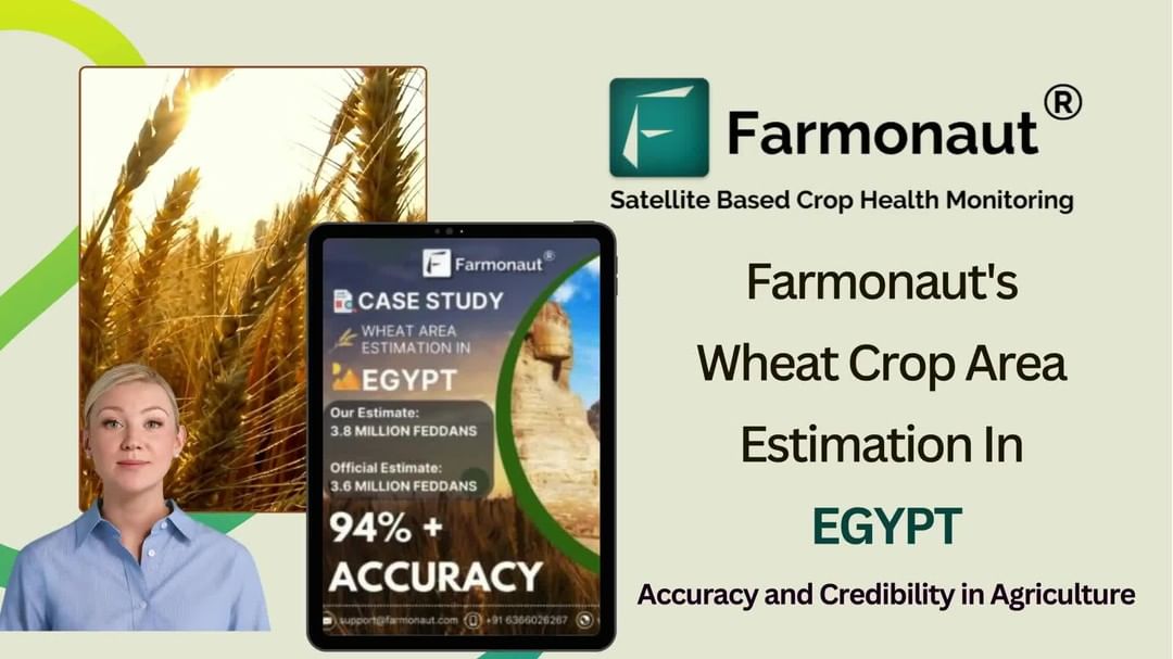
Case Study: Egypt’s Wheat Cultivation Area Estimation
Our recent project in Egypt showcases the power and accuracy of Farmonaut’s crop area estimation technology. Here are the key highlights:
- Estimated Area: 3.8 million Feddans of wheat (approximately 1.6 million hectares)
- Accuracy Rate: An impressive 94% accuracy, validated by the Head of Egypt’s National Wheat Project
- Methodology: Utilization of multi-temporal satellite imagery and advanced AI algorithms
- Impact: Providing crucial data for national food security planning and agricultural policy-making
This achievement not only demonstrates the effectiveness of our technology but also its potential to impact national-level agricultural strategies positively.
The Significance of Accurate Crop Area Estimation
Accurate
crop acreage estimation is more than just a number; it’s a cornerstone of effective agricultural management and policy-making. Here’s why it matters:
- Food Security Planning: Precise estimates help governments and organizations plan for food security, ensuring adequate supplies for the population.
- Resource Allocation: Farmers and agricultural agencies can optimize resource allocation, including water, fertilizers, and labor, based on accurate area estimates.
- Market Intelligence: Traders and policy-makers use these estimates to predict crop yields and market trends, influencing global food prices.
- Environmental Management: Understanding land use patterns helps in sustainable land management and conservation efforts.
- Policy Formulation: Governments rely on accurate crop area data to formulate agricultural policies, subsidy programs, and import/export strategies.
The Technology Behind Farmonaut’s Crop Area Estimation
Our
crop monitoring technology is a culmination of various advanced technologies working in harmony. Here’s a detailed look at the components that make our system so effective:
1. Satellite Imagery Acquisition
We utilize a network of Earth observation satellites to capture high-resolution, multi-spectral images of agricultural areas. These satellites provide regular, wide-coverage imagery that forms the foundation of our analysis.
2. Image Processing and Enhancement
Raw satellite images undergo sophisticated processing to enhance their quality and extract relevant information. This includes atmospheric correction, cloud masking, and spectral band analysis.
3. Machine Learning Algorithms
Our proprietary machine learning models are trained on vast datasets of agricultural imagery. These algorithms can identify crop types, differentiate between cultivated and non-cultivated land, and detect changes over time.
4. Artificial Intelligence for Pattern Recognition
AI systems analyze the processed imagery to recognize patterns indicative of specific crop types and growth stages. This allows for accurate classification and area estimation.
5. Time Series Analysis
By analyzing images captured over time, we can track crop growth cycles, detect anomalies, and improve the accuracy of our estimates.
6. Ground Truth Integration
We incorporate ground-level data and farmer inputs to validate and refine our models, ensuring high accuracy and reliability.
Advantages of Satellite-Based Crop Monitoring Over Traditional Methods
Our
satellite crop monitoring system offers several advantages over conventional crop estimation methods:
| Feature |
Farmonaut Satellite System |
Drone-Based Monitoring |
IoT-Based Farm Monitoring |
| Coverage Area |
Large (Regional/National) |
Limited (Local) |
Very Limited (Farm-specific) |
| Data Collection Frequency |
High (Daily/Weekly) |
Moderate |
Continuous |
| Cost-Effectiveness |
High |
Moderate |
Low |
| Scalability |
Excellent |
Limited |
Poor |
| Weather Independence |
Moderate |
Low |
High |
| Data Processing Complexity |
High |
Moderate |
Low |
Applications of Farmonaut’s Crop Area Estimation Technology
Our advanced
crop yield estimation methods and area estimation technology have wide-ranging applications across the agricultural sector:
- Government Agencies: For national crop inventory, subsidy planning, and food security strategies.
- Agricultural Insurance: To verify claims and assess risk more accurately.
- Commodity Traders: For market intelligence and yield predictions.
- Agribusinesses: To optimize supply chain management and production planning.
- Research Institutions: For studying land use changes, crop rotation patterns, and climate change impacts.
- Farmers and Cooperatives: For better farm management and crop planning.
The Future of Crop Monitoring and Estimation
As we continue to innovate, the future of
crop monitoring technology looks incredibly promising. Here are some trends and developments we’re excited about:
- Integration with IoT: Combining satellite data with ground-based IoT sensors for even more accurate and real-time monitoring.
- Advanced AI and Deep Learning: Developing more sophisticated algorithms for better crop identification and yield prediction.
- Hyperspectral Imaging: Utilizing more detailed spectral data for enhanced crop health analysis and early stress detection.
- Blockchain Integration: Enhancing data security and traceability in crop monitoring and supply chain management.
- Climate Change Adaptation: Using our technology to help farmers adapt to changing climate patterns and optimize crop selection.
Farmonaut’s Commitment to Accessible Technology
At Farmonaut, we believe that advanced agricultural technology should be accessible to all farmers, regardless of the scale of their operations. That’s why we’ve developed user-friendly interfaces and mobile applications to bring our technology directly to farmers’ fingertips.
Our mobile app, available on both
Android and
iOS, provides easy access to crucial farm data and insights. For those looking to integrate our technology into their existing systems, we offer a robust
API with comprehensive
documentation.
Empowering Farmers Across Languages
We understand the importance of language accessibility in agriculture. That’s why we’re proud to offer our services in multiple languages, including
precision agriculture in Hindi. This initiative ensures that farmers across India can benefit from our advanced technology, breaking down language barriers in agricultural innovation.
Join the Agricultural Revolution with Farmonaut
As we continue to push the boundaries of what’s possible in precision agriculture, we invite you to be part of this exciting journey. Whether you’re a farmer looking to optimize your crops, a researcher seeking cutting-edge agricultural data, or a government agency aiming to enhance food security, Farmonaut has the tools and expertise to help you succeed.
Ready to transform your approach to agriculture?
Get started with Farmonaut today and experience the future of farming.
Subscribe to Farmonaut
Frequently Asked Questions (FAQ)
Q1: How accurate is Farmonaut’s crop area estimation technology?
A1: Our technology has demonstrated an impressive 94% accuracy rate, as validated in our recent project estimating Egypt’s wheat cultivation area.
Q2: Can Farmonaut’s technology be used for all types of crops?
A2: Yes, our technology is versatile and can be applied to a wide range of crop types, from grains to fruits and vegetables.
Q3: How often is the satellite imagery updated?
A3: The frequency of updates can vary depending on the specific needs and subscription plan, but we typically provide weekly or bi-weekly updates.
Q4: Is Farmonaut’s technology suitable for small-scale farmers?
A4: Absolutely! We’ve designed our solutions to be scalable and accessible to farmers of all sizes, from small holdings to large agricultural enterprises.
Q5: How does Farmonaut ensure the privacy and security of farm data?
A5: We employ robust data encryption and secure storage practices to protect all user data. We also adhere to strict privacy policies and comply with international data protection regulations.
Q6: Can Farmonaut’s technology help in predicting crop yields?
A6: Yes, our advanced algorithms not only estimate crop areas but also provide yield predictions based on historical data, current crop health, and environmental factors.
Q7: How does weather data integrate with Farmonaut’s crop monitoring system?
A7: Our system incorporates real-time weather data and forecasts to provide more accurate crop health assessments and growth predictions.
Q8: Is training required to use Farmonaut’s technology?
A8: While our interface is designed to be user-friendly, we provide comprehensive training and support to ensure users can maximize the benefits of our technology.
Q9: Can Farmonaut’s technology be integrated with other farm management systems?
A9: Yes, we offer API integration options that allow our technology to be seamlessly incorporated into existing farm management systems.
Q10: How does Farmonaut contribute to sustainable farming practices?
A10: By providing precise data on crop health and resource needs, our technology helps farmers optimize their use of water, fertilizers, and pesticides, contributing to more sustainable and environmentally friendly farming practices.
As we conclude this in-depth exploration of Farmonaut’s advanced crop area estimation technology, we hope you’ve gained valuable insights into how we’re revolutionizing agriculture. Our commitment to precision, innovation, and accessibility continues to drive us forward in our mission to empower farmers and transform agricultural practices worldwide.
Remember to stay connected with us for the latest updates and innovations in agricultural technology. Like, subscribe, and turn on notifications to be at the forefront of the agricultural revolution. Together, we’re cultivating a smarter, more sustainable future for farming.
Join us in reshaping the future of agriculture with precision, innovation, and technology. The fields of tomorrow are being sown today, and Farmonaut is leading the way.
#Farmonaut #AgTech #CropEstimation #PrecisionAgriculture #SustainableFarming #FutureOfFarming