Wheat Area Estimation in MP, Sehore
By Farmonaut
Sehore, located in the state of Madhya Pradesh, India, is known for its agricultural activities, with wheat being one of the primary crops cultivated in the region. Keeping track of the wheat area under cultivation is crucial for farmers, researchers, and policymakers to monitor agricultural productivity and plan for efficient resource allocation. In recent times, Farmonaut, an innovative agri-tech company, has emerged as a key player in conducting accurate wheat area estimations in Sehore and other agricultural regions.
Farmonaut utilizes advanced remote sensing technology, satellite imagery, and artificial intelligence algorithms to provide precise and up-to-date information on crop health, yield predictions, and area estimations. By harnessing the power of these cutting-edge technologies, Farmonaut helps farmers make data-driven decisions, optimize resource allocation, and improve overall agricultural practices.
One of the key challenges faced by farmers and researchers in estimating wheat area is the vast expanse of agricultural land and the time-consuming and labor-intensive process of manually surveying the fields. Traditional methods often rely on ground surveys or manual counting, which can be highly subjective and prone to errors. Additionally, the process is time-consuming and does not provide real-time information, making it difficult for stakeholders to respond quickly to changing conditions.
Farmonaut addresses these challenges by offering an automated and accurate solution for wheat area estimation. The company collects high-resolution satellite imagery of agricultural areas, including Sehore, on a regular basis. This imagery is then processed using state-of-the-art algorithms to detect and classify wheat fields, distinguishing them from other land cover types. By analyzing the satellite imagery, Farmonaut can accurately estimate the extent of wheat cultivation in Sehore and provide valuable insights to farmers and stakeholders.
WHY IS AREA ESTIMATION IMPORTANT?
Accurate and timely data on crop area, yield, and production play a vital role in planning and resource allocation for the agricultural sector. Policymakers and planners rely on this information to develop effective agricultural policies and make critical decisions regarding procurement, storage, public distribution, and import/export activities.
The estimation of crop area is crucial for:
- ensuring food security at the global or national level.
- It allows policymakers to make informed decisions on import and export policies, ensuring that the right amount of food is available to meet the population’s needs.
- Additionally, accurate crop area estimation enables policymakers to adjust food prices effectively, ensuring affordability and stability in the market.
HOW IS AREA ESTIMATION CONDUCTED ?
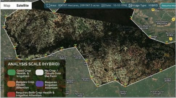
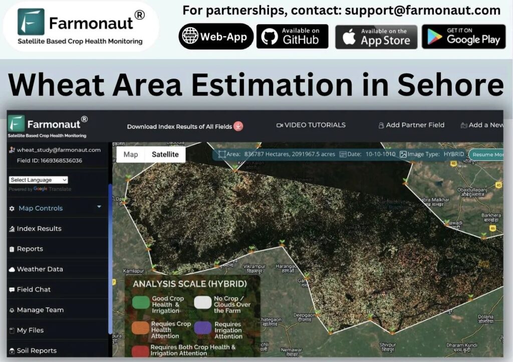
Farmonaut’s Automated Crop Area Estimation Systems have successfully identified the current wheat area under cultivation in Sehore, Madhya Pradesh. The system categorizes the identified areas into different colors to indicate the health of the wheat crop. Yellow, orange, or red locations indicate areas where the wheat crop appears to be underperforming and may require further inspection.
On the other hand, locations shown in shades of green represent areas where the wheat crop is healthy. This information allows farmers, researchers, and stakeholders to pinpoint areas of concern and prioritize their efforts in addressing potential issues affecting wheat crop health. By identifying underperforming areas, farmers can take appropriate measures such as adjusting irrigation, applying fertilizers, or implementing pest control strategies to improve the health and productivity of the wheat crop. Conversely, areas with healthy wheat crops can serve as reference points for best practices and provide insights into successful cultivation techniques.
The use of color-coded visualization helps in easily interpreting the health status of the wheat crop across different locations in Sehore. By leveraging automated crop area estimation systems, stakeholders can make informed decisions and take targeted actions to optimize agricultural productivity and ensure a successful wheat harvest.
CONCLUSION
Farmonaut’s wheat area estimation service in Sehore, MP, showcases the transformative potential of agri-tech in revolutionizing traditional farming practices. By leveraging the power of remote sensing and artificial intelligence, the company provides accurate, reliable, and real-time information that empowers farmers, researchers, and policymakers alike.
As technology continues to advance, it is imperative that agricultural stakeholders embrace these innovative solutions to optimize agricultural productivity, promote sustainability, and enhance food security. Farmonaut’s wheat area estimation in Sehore, MP, stands as a testament to the positive impact that agri-tech can have on the farming community and the broader agricultural landscape.
Top Clients of Farmonaut