TRST01, a company founded in 2019 and based in Madhapur, India, focuses on climate technology within the environmental services industry. TRST01 integrates Farmonaut’s remote sensing data seamlessly into its operations, bolstering its ability to detect and monitor deforestation and afforestation activities. This integration enriches TRST01 analytical capabilities by incorporating advanced insights derived from Farmonaut’s sophisticated remote sensing technology.
Challenges Encountered by TRST01
- Limited ability to monitor and analyze land cover changes and vegetation dynamics: This denotes challenges in accurately observing and understanding changes in land cover and vegetation dynamics, essential for ecological monitoring, resource management, and biodiversity preservation.
- Inability to accurately map and monitor deforestation and afforestation: This highlights challenges in accurately mapping and monitoring deforestation and afforestation due to a lack of precise data and monitoring systems. These are crucial for assessing environmental impacts and implementing conservation measures.
- Lack of precise data for sustainable farming practices and supply chain management: The challenge is the lack of precise data for supporting sustainable farming practices and effective supply chain management. This encompasses soil health, water usage, crop yields, and the environmental footprint of agricultural activities. Without accurate data, optimizing farming techniques, reducing resource usage, and ensuring supply chain sustainability are challenging.
- Inability to provide real-time monitoring and reporting of environmental impacts: This point indicates a deficiency in systems capable of monitoring and reporting environmental impacts in real time. Without timely information on factors such as pollution levels, habitat destruction, or ecosystem changes, it becomes difficult to respond promptly to environmental threats, mitigate risks, and enact appropriate conservation measures.
- Limited ability to assess and address climate change impacts on agriculture and food production: This highlights challenges in assessing and mitigating climate change impacts on agriculture. It indicates a lack of tools to evaluate effects on crop yields, water availability, pest patterns, and food security. Without robust assessment, implementing adaptive strategies in agriculture becomes difficult.
Transforming Agriculture with Farmonaut Services
Farmonaut offers farmers and businesses satellite-based crop health monitoring and field mapping services. Their services include crop health monitoring, area estimation, water stress, carbon content, soil health, and other parameters. Farmonaut’s satellite imagery is updated every 2-5 days and has a resolution of 10 meters, which is twice as good as Google Maps. They have worked with international corporations such as Sunpalm Australia, Troforte Fertilizer Australia, Agro Drones Israel, Grupo Los Grobo Argentina, and Godrej Agrovet.
With around 6500+ farms covering approximately 30,000+ Ha of area, Farmonaut has already monitored with TRST01.
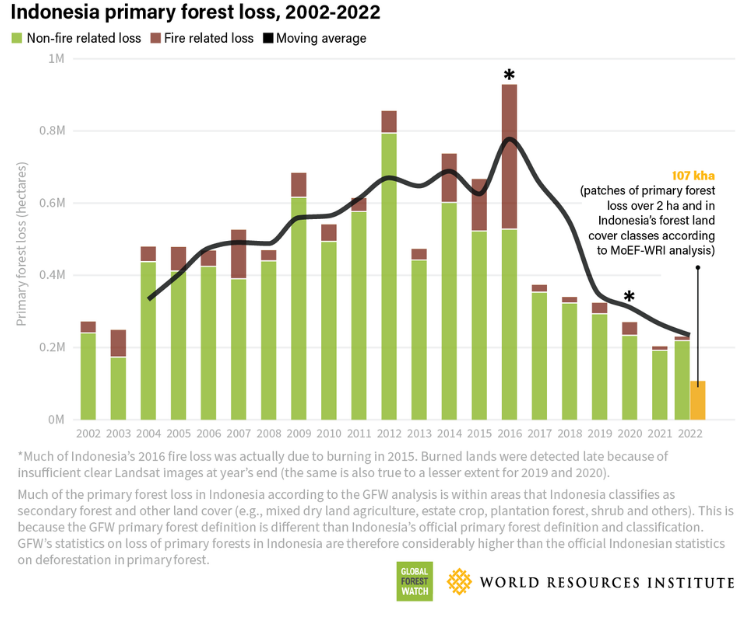
Deforestation
Deforestation is the process of clearing forests for various purposes, such as agriculture, urbanization, logging, and infrastructure development. It has significant environmental impacts, including loss of biodiversity, disruption of ecosystems, soil erosion, and contribution to climate change through increased greenhouse gas emissions.
Farmonaut's Deforestation Monitoring Experise
- Satellite Imagery Analysis: Farmonaut uses satellite imagery from sources like Landsat and Sentinel-2 to detect changes in forest cover.
- Machine Learning Algorithms: Advanced algorithms automatically identify patterns indicative of deforestation.
- Timely Detection: Enables quick response by environmental authorities and policymakers.
- Monitoring and Reporting: Provides ongoing tracking of deforestation trends for effective conservation efforts.
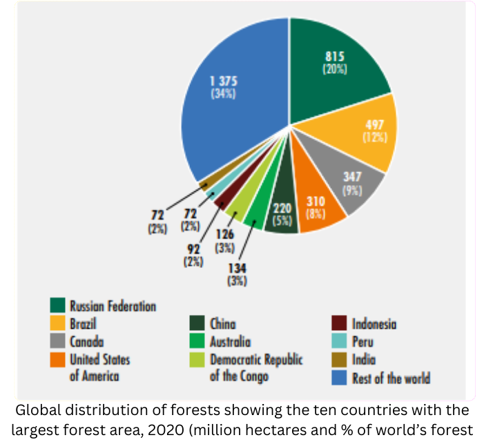
Global Forest Coverage: An Overview Till 2020
In 2020, global forest cover reached 4.06 billion hectares, accounting for one-third of Earth’s land area. The FRA 2020 noted a 30-year decline of 178 million hectares in net forest loss since 1990. Notably, 399 million hectares are now protected for soil and water, a 119 million-hectare increase since 1990. Additionally, 424 million hectares are designated for biodiversity conservation, with 111 million hectares added since 1990. FRA 2020 aids in policy development for sustainable forest management, stressing their crucial role in biodiversity conservation.
Farmonaut's Solutions
API Integration Mastery:
- Providing access to various data types, including image types, colormaps, and analysis scales.
- Offering vegetation water stress, evapotranspiration, soil organic carbon, and weather forecast data, even during cloudy weather through radar sensors.
- Helping monitor over 1 million hectares of farmland worldwide.
- Assisting companies such as Godrej Agrovet Limited, ITC Limited, Coromandel International Limited, and Troforte Innovations, among others.
Satellite Crop Health Monitoring:
- Enabling users to access various data, including image types, colormaps, analysis scales, and other relevant information, to develop custom agricultural remote sensing solutions.
- Automatically estimating crops and their sown area from anywhere around the world directly through their web platform itself.
Impact and Result
Impact: TRST01 integrates Farmonaut’s remote sensing data, enhancing its capacity to detect and monitor deforestation and afforestation activities. This integration strengthens TRST01’s analytical capabilities by incorporating valuable insights from Farmonaut’s advanced remote sensing technology.
Result: This integration facilitates early detection of deforestation, enabling proactive measures to mitigate associated risks. Farmonaut Platform has seen a significant expansion of 30,000 hectares and over 6500 farms, highlighting the increased monitoring scope.
Our Prestigious Clients