Revolutionizing Agriculture: Precision Farming with Satellite Monitoring and Geospatial Intelligence for Sustainable Crop Management
In today’s rapidly evolving agricultural landscape, we at Farmonaut are at the forefront of a technological revolution that is transforming the way we approach farming. Our mission is to make precision agriculture accessible and affordable to farmers worldwide, leveraging cutting-edge satellite monitoring and geospatial intelligence to enhance crop management and promote sustainable agricultural practices.
The Power of Satellite Monitoring in Modern Agriculture
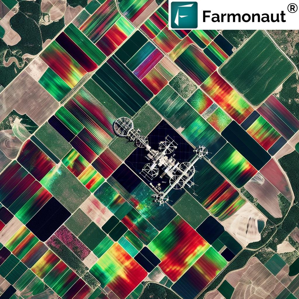
Satellite monitoring has emerged as a game-changer in the agricultural sector, offering unprecedented insights into crop health, soil conditions, and overall farm management. At Farmonaut, we harness this technology to provide farmers with real-time, actionable data that can significantly improve their decision-making processes.
Crop Monitoring: A New Era of Precision
Our advanced crop monitoring systems utilize high-resolution satellite imagery to track crop development throughout the growing season. This allows farmers to:
- Detect early signs of crop stress or disease
- Optimize irrigation schedules based on precise soil moisture data
- Identify areas of nutrient deficiency for targeted fertilizer application
- Monitor crop growth patterns and predict yield potential
By leveraging these insights, farmers can make informed decisions that lead to improved crop health, reduced input costs, and ultimately, higher yields.
Soil Analysis: The Foundation of Healthy Crops
Understanding soil health is crucial for sustainable agriculture. Our satellite-based soil analysis tools provide detailed information on:
- Soil moisture levels
- Organic carbon content
- Soil composition and structure
- Nutrient availability
This data enables farmers to implement targeted soil management strategies, improving soil health and crop productivity while reducing environmental impact.
Geospatial Intelligence: Transforming Agricultural Practices
At Farmonaut, we believe that geospatial intelligence is the key to unlocking the full potential of modern agriculture. Our platform integrates various data sources to create a comprehensive picture of farm operations, including:
- Satellite imagery
- Weather data
- Historical crop performance
- Agronomic models
By analyzing this data using advanced algorithms and machine learning techniques, we provide farmers with actionable insights that can dramatically improve their agricultural practices.
Field Boundary Detection and Crop Classification
Our field detection and crop classification tools use AI-powered image analysis to accurately map field boundaries and identify crop types. This information is crucial for:
- Precise area calculations for input allocation
- Crop rotation planning
- Compliance with agricultural regulations
- Efficient resource management
By automating these processes, we save farmers valuable time and resources while improving the accuracy of their farm management decisions.
Yield Prediction: Forecasting for Better Planning
Accurate yield prediction is essential for effective farm management and market planning. Our advanced algorithms analyze historical data, current crop conditions, and weather forecasts to provide reliable yield estimates. This enables farmers to:
- Optimize harvest timing
- Plan storage and transportation logistics
- Make informed marketing decisions
- Secure better contracts with buyers
By providing these insights well in advance of harvest, we help farmers maximize their profits and reduce post-harvest losses.
Remote Sensing: The Eyes in the Sky
Remote sensing technology forms the backbone of our satellite monitoring capabilities. We utilize data from various satellite constellations, including Sentinel and Landsat, to provide comprehensive coverage of agricultural areas worldwide. This allows us to offer:
- High-frequency monitoring (up to daily updates in some regions)
- Multi-spectral analysis for detailed crop health assessment
- Large-scale monitoring of vast agricultural areas
- Historical data analysis for long-term trend identification
Our remote sensing capabilities enable us to detect subtle changes in crop conditions that might be invisible to the naked eye, providing farmers with a powerful tool for proactive management.
Vegetation Indices: Measuring Crop Health with Precision
We employ a range of vegetation indices to assess crop health and vigor, including:
- NDVI (Normalized Difference Vegetation Index): Measures overall plant health and biomass
- NDMI (Normalized Difference Moisture Index): Indicates plant water content and stress levels
- NDWI (Normalized Difference Water Index): Assesses water content in leaves and canopies
- MSAVI (Modified Soil Adjusted Vegetation Index): Minimizes soil background influence for accurate vegetation analysis
- NDRE (Normalized Difference Red Edge): Sensitive to chlorophyll content, useful for nutrient management
These indices provide a comprehensive view of crop health, allowing for targeted interventions and optimized resource allocation.
Precision Farming: Maximizing Efficiency and Sustainability
At Farmonaut, we’re committed to advancing precision farming techniques that optimize resource use and minimize environmental impact. Our platform supports various precision agriculture applications, including:
- VRA (Variable Rate Application): Tailoring input application rates based on field variability
- Precision irrigation: Optimizing water use based on soil moisture data and crop water requirements
- Targeted pest and disease management: Identifying problem areas for focused treatment
- Zone management: Dividing fields into management zones for customized treatment
By enabling these precision farming practices, we help farmers reduce input costs, improve crop quality, and minimize their environmental footprint.
Weather Intelligence: Informing Critical Decisions
Accurate weather forecasting is crucial for effective farm management. Our platform integrates high-resolution weather data and forecasts, providing:
- Short-term and seasonal weather predictions
- Alerts for extreme weather events
- Historical weather analysis for trend identification
- Crop-specific weather impact assessments
This weather intelligence allows farmers to plan their activities more effectively, reducing weather-related risks and optimizing resource use.
Sustainable Agriculture: Balancing Productivity and Environmental Stewardship
At Farmonaut, we believe that sustainable agriculture is not just an option but a necessity. Our platform supports various sustainable farming practices, including:
- Optimized input use to reduce environmental impact
- Soil health management for long-term sustainability
- Water conservation through precision irrigation
- Carbon sequestration monitoring and management
By providing the tools and insights needed to implement these practices, we’re helping farmers build more resilient and sustainable agricultural systems.
Organic Carbon Monitoring: Building Healthy Soils
Soil organic carbon is a critical indicator of soil health and plays a vital role in sustainable agriculture. Our platform offers tools for monitoring and managing soil organic carbon levels, enabling farmers to:
- Track changes in soil carbon content over time
- Implement practices that enhance carbon sequestration
- Improve soil structure and water retention capacity
- Increase soil biodiversity and overall soil health
By focusing on soil organic carbon management, farmers can improve their soil’s productivity while contributing to climate change mitigation efforts.
Forest Monitoring: Extending Geospatial Intelligence Beyond Agriculture
While our primary focus is on agricultural applications, our satellite monitoring and geospatial intelligence capabilities also extend to forest monitoring. This allows us to support:
- Deforestation detection and prevention
- Forest health assessment and management
- Biodiversity conservation efforts
- Carbon stock estimation in forested areas
By offering these forest monitoring services, we contribute to broader environmental conservation efforts and support sustainable land use practices.
Analytics and Insights: Turning Data into Action
At the heart of our platform is a powerful analytics engine that transforms raw data into actionable insights. Our analytics capabilities include:
- Advanced image processing and interpretation
- Machine learning algorithms for pattern recognition and prediction
- Time-series analysis for trend identification
- Custom reports and visualizations for easy interpretation
These analytics tools empower farmers to make data-driven decisions, optimizing their operations and improving overall farm performance.
Harvest Analytics: Optimizing the Critical Phase
The harvest period is one of the most critical phases in the agricultural cycle. Our harvest analytics tools provide valuable insights to optimize this crucial stage:
- Harvest timing recommendations based on crop maturity and weather forecasts
- Yield estimation maps for efficient harvesting logistics
- Post-harvest loss reduction strategies
- Quality assessment predictions for better market planning
By leveraging these harvest analytics, farmers can maximize their crop yields and quality while minimizing losses and operational costs.
Scouting and Field Management: Bridging the Digital and Physical
While satellite monitoring provides a wealth of information, on-the-ground scouting remains an essential part of farm management. Our platform includes tools to support and enhance field scouting activities:
- Mobile apps for in-field data collection and verification
- Integration of ground-truth data with satellite observations
- Task management and prioritization based on satellite-detected issues
- Historical scouting records for trend analysis and decision support
By combining satellite intelligence with on-the-ground observations, we provide a comprehensive solution for effective field management.
Maps and Visualization: Making Data Accessible
To make our geospatial intelligence easily accessible and interpretable, we offer a range of mapping and visualization tools:
- Interactive maps with multiple data layers
- Time-lapse visualizations of crop development
- Customizable reports and dashboards
- Export options for integration with other farm management software
These visualization tools help farmers and agronomists quickly identify patterns, anomalies, and opportunities within their fields, facilitating faster and more informed decision-making.
API Integration: Extending the Power of Geospatial Intelligence
For developers and businesses looking to integrate our geospatial intelligence into their own applications, we offer a robust API solution. Our API provides access to:
- Raw satellite imagery and processed vegetation indices
- Weather data and forecasts
- Soil moisture and other environmental parameters
- Crop classification and yield prediction models
This API access allows for seamless integration of our data and analytics into existing farm management systems, precision agriculture tools, and other agricultural applications. For more information on our API capabilities, visit our API documentation.
Comparison: Farmonaut vs. Traditional Methods
To illustrate the advantages of our satellite monitoring and geospatial intelligence platform, we’ve prepared a comparison table showcasing Farmonaut’s capabilities versus traditional methods:
| Feature | Farmonaut’s Solution | Traditional Methods |
|---|---|---|
| Crop Health Assessment | Daily satellite monitoring with multi-spectral analysis | Periodic visual inspections, limited coverage |
| Yield Prediction | AI-powered models using historical data, current conditions, and weather forecasts | Manual sampling and estimation, prone to human error |
| Soil Moisture Monitoring | Continuous satellite-based measurements with high spatial resolution | Spot checks with soil probes, limited spatial coverage |
| Precision Farming Applications | VRA maps, zone management, and targeted interventions based on high-resolution data | Uniform application of inputs, limited ability to address field variability |
| Data Collection Frequency | Daily updates (cloud permitting) for most areas | Dependent on manual scouting, typically weekly or less frequent |
| Coverage Area | Entire fields and farms, regardless of size or accessibility | Limited by time and resources for physical inspections |
| Data Analysis | Advanced analytics and machine learning for pattern recognition and prediction | Often relies on experience and intuition, limited data-driven insights |
| Environmental Impact | Optimized resource use, reduced chemical inputs, lower carbon footprint | Potential overuse of resources, higher environmental impact |
As the table demonstrates, Farmonaut’s geospatial intelligence platform offers significant advantages in terms of accuracy, efficiency, and sustainability compared to traditional farming methods.
Conclusion: Embracing the Future of Agriculture
At Farmonaut, we’re committed to driving the future of agriculture through innovative satellite monitoring and geospatial intelligence solutions. By providing farmers with powerful, easy-to-use tools for crop monitoring, soil analysis, and precision farming, we’re helping to create a more sustainable and productive agricultural sector.
Our platform not only improves farm productivity and profitability but also contributes to broader goals of environmental conservation and food security. As we continue to refine our technologies and expand our services, we invite farmers, agronomists, and agricultural businesses to join us in this journey towards a smarter, more sustainable future for agriculture.
To experience the power of Farmonaut’s geospatial intelligence platform for yourself, visit our web application or download our mobile app for Android or iOS.
Frequently Asked Questions (FAQ)
- Q: How often is satellite imagery updated on the Farmonaut platform?
A: Our platform provides daily updates for most areas, cloud cover permitting. However, the frequency may vary depending on the specific satellite constellations covering your region. - Q: Can Farmonaut’s satellite monitoring detect specific crop diseases?
A: While our platform can detect signs of crop stress that may indicate disease, it cannot diagnose specific diseases. However, it can alert farmers to potential issues, allowing for timely on-ground investigation and intervention. - Q: How accurate are Farmonaut’s yield predictions?
A: Our yield prediction models have shown high accuracy in many crop types and regions. However, accuracy can vary depending on factors such as crop type, available historical data, and unforeseen events like extreme weather. - Q: Is Farmonaut’s platform suitable for small-scale farmers?
A: Yes, our platform is designed to be scalable and accessible to farmers of all sizes. We offer various subscription tiers to accommodate different farm sizes and needs. - Q: How does Farmonaut ensure the privacy and security of farm data?
A: We take data privacy and security very seriously. All farm data is encrypted and stored securely, and we never share individual farm data without explicit permission. - Q: Can Farmonaut’s platform integrate with other farm management software?
A: Yes, we offer API access that allows for integration with many popular farm management systems. For more details, please refer to our API documentation. - Q: Does Farmonaut provide support for interpreting the data and insights?
A: Yes, we offer customer support and training to help users interpret and act on the insights provided by our platform. We also have a knowledge base and regularly publish educational content. - Q: Can Farmonaut’s platform be used for organic farming?
A: Absolutely. Our platform is valuable for all types of farming, including organic. It can help organic farmers optimize their practices and monitor crop health without relying on synthetic inputs. - Q: How does Farmonaut’s soil moisture monitoring compare to in-ground sensors?
A: While in-ground sensors provide point measurements, our satellite-based soil moisture monitoring offers a comprehensive view of entire fields. This allows for better understanding of spatial variability in soil moisture. - Q: Can Farmonaut’s platform help with compliance for agricultural subsidies or certifications?
A: Yes, our platform can assist with compliance by providing accurate field boundary mapping, crop type classification, and historical records of farming practices. However, specific requirements may vary by region and program.
Ready to revolutionize your farming practices with Farmonaut’s advanced satellite monitoring and geospatial intelligence platform? Subscribe now to get started: