NDWI Interpretation: Unlocking the Secrets of Water Content in Satellite Imagery
In the ever-evolving world of precision agriculture and remote sensing, understanding water content in vegetation and soil is crucial for effective farm management. At Farmonaut, we’re committed to providing farmers and agricultural professionals with cutting-edge tools to optimize their operations. One of the most valuable indices we utilize is the Normalized Difference Water Index (NDWI). In this comprehensive guide, we’ll delve deep into NDWI interpretation, exploring its significance, calculation methods, and practical applications in modern agriculture.
What is NDWI?
The Normalized Difference Water Index (NDWI) is a remote sensing-derived index that provides valuable insights into the water content of vegetation and soil. Developed by Gao in 1996, NDWI has become an essential tool for monitoring drought conditions, assessing plant health, and managing irrigation practices.
NDWI leverages the unique spectral properties of water in vegetation to estimate moisture content. By utilizing near-infrared (NIR) and short-wave infrared (SWIR) bands from satellite imagery, NDWI can effectively distinguish between dry and wet areas, making it an invaluable resource for precision agriculture.
The Importance of NDWI in Agriculture
Understanding water content in crops and soil is crucial for several reasons:
- Drought Monitoring: NDWI helps identify areas experiencing water stress, allowing for early intervention.
- Irrigation Management: By providing insights into soil moisture levels, NDWI enables more efficient water usage.
- Crop Health Assessment: Water content is a key indicator of plant health and potential yield.
- Environmental Monitoring: NDWI aids in tracking changes in wetlands and water bodies over time.
At Farmonaut, we integrate NDWI analysis into our satellite-based crop health monitoring system, providing farmers with actionable insights to optimize their operations.
NDWI Calculation: The Science Behind the Index
The NDWI is calculated using the following formula:
NDWI = (NIR – SWIR) / (NIR + SWIR)
Where:
- NIR = Near-Infrared reflectance
- SWIR = Short-Wave Infrared reflectance
This formula capitalizes on the fact that water absorbs light strongly in the SWIR band while reflecting strongly in the NIR band. By comparing these two bands, we can effectively estimate water content in vegetation and soil.
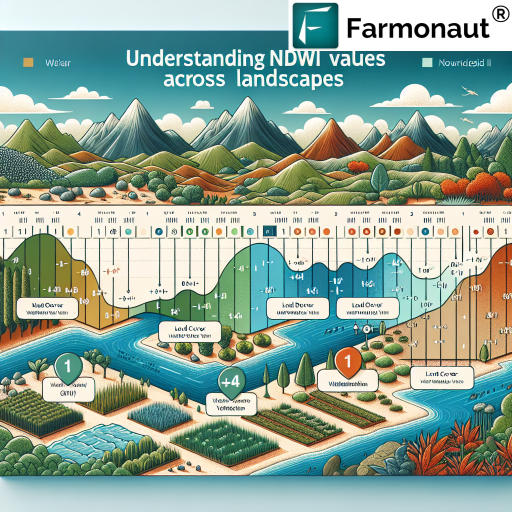
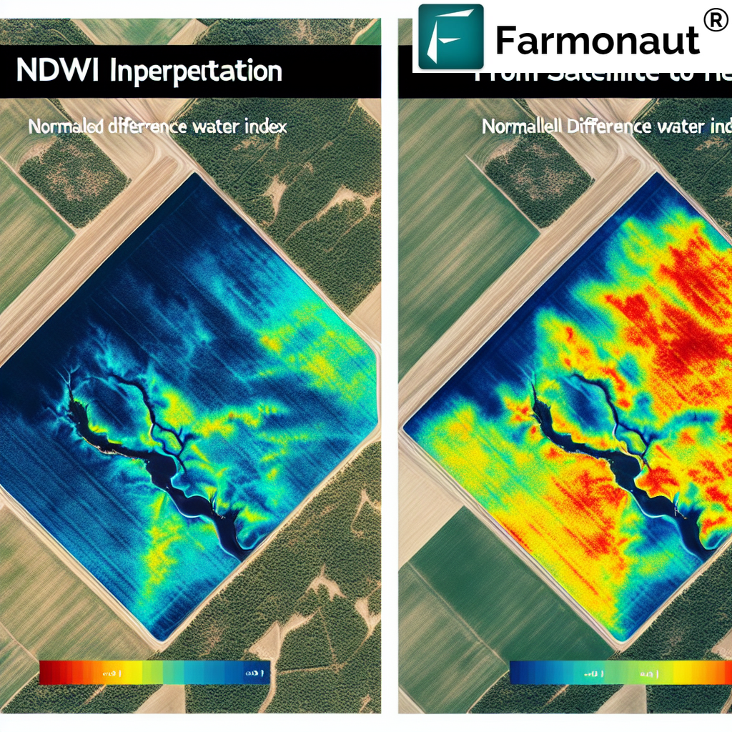
NDWI Values Interpretation: Decoding the Results
Understanding NDWI values is crucial for accurate interpretation of water content in vegetation and soil. Let’s break down the typical range of NDWI values and what they signify:
- NDWI > 0.5: High water content, typically indicating healthy vegetation or water bodies.
- 0.3 < NDWI < 0.5: Moderate water content, often seen in vegetation with adequate moisture.
- 0 < NDWI < 0.3: Low water content, potentially indicating water stress in vegetation.
- NDWI < 0: Very low or no water content, often associated with bare soil or built-up areas.
It’s important to note that NDWI values can vary depending on factors such as vegetation type, growth stage, and local environmental conditions. At Farmonaut, our AI-powered Jeevn Advisory System takes these variables into account to provide accurate, context-specific interpretations of NDWI data.
Practical Applications of NDWI in Precision Agriculture
NDWI interpretation has numerous practical applications in modern farming. Here are some ways we at Farmonaut help farmers leverage NDWI data:
1. Irrigation Optimization
By analyzing NDWI values across a field, farmers can identify areas that require more or less irrigation. This targeted approach helps conserve water and reduce costs while ensuring optimal crop health.
2. Drought Monitoring and Management
Regular NDWI monitoring allows for early detection of drought conditions. Our platform alerts farmers to potential water stress, enabling proactive measures to mitigate crop damage.
3. Crop Health Assessment
NDWI values correlate strongly with overall plant health. By tracking NDWI trends over time, farmers can identify potential issues before they become visible to the naked eye.
4. Yield Prediction
Water content is a crucial factor in determining crop yield. By analyzing NDWI data throughout the growing season, we help farmers make more accurate yield predictions.
5. Environmental Monitoring
Beyond individual farms, NDWI is valuable for monitoring broader environmental changes, such as wetland dynamics and the impact of climate change on water resources.
Farmonaut’s Approach to NDWI Interpretation
At Farmonaut, we’ve integrated advanced NDWI interpretation into our satellite-based farm management platform. Here’s how we leverage this powerful index:
- High-Resolution Satellite Imagery: We use multispectral satellite data to calculate NDWI values with high spatial and temporal resolution.
- AI-Powered Analysis: Our Jeevn AI Advisory System combines NDWI data with other indicators and historical trends to provide context-aware insights.
- User-Friendly Visualization: We present NDWI data in easy-to-understand maps and charts, making it accessible to farmers of all technical backgrounds.
- Integration with Other Indices: NDWI is analyzed alongside other vegetation indices like NDVI for a comprehensive view of crop health.
- Customized Alerts: Our system sends notifications when NDWI values indicate potential water stress or other issues requiring attention.
By combining NDWI interpretation with our other advanced technologies, we provide farmers with a powerful toolkit for precision agriculture.
Challenges and Considerations in NDWI Interpretation
While NDWI is a valuable tool, it’s important to be aware of potential challenges in its interpretation:
- Atmospheric Effects: Cloud cover and atmospheric conditions can affect NDWI calculations. Our platform uses advanced algorithms to minimize these impacts.
- Vegetation Type Variations: Different crop types may have varying NDWI baselines. We account for this by calibrating our interpretations based on specific crop profiles.
- Temporal Variations: NDWI values can change rapidly due to rainfall or irrigation events. Regular monitoring is crucial for accurate interpretation.
- Soil Background Influence: In areas with sparse vegetation, soil properties can influence NDWI values. Our analysis takes this into account for more accurate results.
At Farmonaut, we’re constantly refining our NDWI interpretation methods to address these challenges and provide the most reliable insights possible.
The Future of NDWI in Precision Agriculture
As technology continues to advance, we anticipate even more powerful applications of NDWI in agriculture:
- Integration with IoT Devices: Combining satellite-derived NDWI data with ground-based sensors for even more precise water management.
- Machine Learning Enhancements: Advanced algorithms will improve NDWI interpretation accuracy and provide more nuanced insights.
- Hyperspectral Imaging: Future satellites may offer more detailed spectral data, allowing for even more accurate water content estimation.
- Climate Change Adaptation: NDWI will play a crucial role in helping farmers adapt to changing precipitation patterns and water availability.
At Farmonaut, we’re committed to staying at the forefront of these developments, continuously improving our platform to provide farmers with the most advanced tools available.
How Farmonaut Leverages NDWI for Precision Agriculture
Our platform integrates NDWI interpretation seamlessly into a comprehensive farm management solution:
- Regular Monitoring: We provide frequent NDWI updates through our satellite-based monitoring system, allowing farmers to track water content trends over time.
- Custom Alerts: Our AI-powered system sends notifications when NDWI values indicate potential water stress or other issues requiring attention.
- Integration with Weather Data: We combine NDWI analysis with local weather forecasts to provide more accurate irrigation recommendations.
- Historical Analysis: Farmers can view historical NDWI data to identify patterns and optimize long-term water management strategies.
- Mobile Access: All NDWI data and insights are available through our mobile app, allowing farmers to make informed decisions from anywhere.
To experience the power of our NDWI interpretation and other advanced features, try Farmonaut today.
NDWI vs. Other Water-Related Indices
While NDWI is a powerful tool, it’s not the only index used for water content analysis. Let’s compare NDWI with some other common indices:
| Index | Purpose | Strengths | Limitations |
|---|---|---|---|
| NDWI | Vegetation water content | Sensitive to leaf water content | Can be affected by soil background |
| NDMI (Normalized Difference Moisture Index) | Vegetation moisture stress | Good for forest canopy analysis | Less sensitive to water in sparse vegetation |
| MNDWI (Modified NDWI) | Open water body detection | Better at distinguishing water from built-up areas | Less effective for vegetation water content |
| WRI (Water Ratio Index) | Water body mapping | Effective in areas with mixed land cover | Can be sensitive to atmospheric effects |
At Farmonaut, we utilize a combination of these indices to provide the most comprehensive water content analysis possible, tailored to each farmer’s specific needs.
Case Studies: NDWI in Action
To illustrate the practical applications of NDWI interpretation, let’s explore how farmers around the world are using this technology to improve their operations:
1. Drought Management in California Vineyards
Vineyard owners in California’s Napa Valley use NDWI data to optimize irrigation during drought periods. By closely monitoring NDWI values, they can maintain grape quality while minimizing water usage.
2. Rice Cultivation in Southeast Asia
Rice farmers in Thailand leverage NDWI to ensure optimal water levels in their paddies. This precise water management leads to improved yields and reduced water waste.
3. Forestry Management in Canada
Forest managers in British Columbia use NDWI to monitor forest health and detect early signs of drought stress, helping to prevent wildfires and maintain ecosystem balance.
4. Precision Irrigation in Australian Cotton Fields
Cotton farmers in New South Wales utilize NDWI data to implement variable-rate irrigation systems, applying water only where and when it’s needed most.
These case studies demonstrate the versatility and effectiveness of NDWI interpretation across various agricultural contexts.
Integrating NDWI with Other Farmonaut Technologies
At Farmonaut, we believe in a holistic approach to farm management. That’s why we integrate NDWI interpretation with our other cutting-edge technologies:
- Blockchain-Based Traceability: We link NDWI data to our blockchain system, providing a transparent record of water management practices for supply chain verification.
- Carbon Footprinting: By optimizing water usage through NDWI analysis, farmers can reduce their carbon footprint, which is tracked and reported through our platform.
- Fleet and Resource Management: NDWI insights inform our resource management tools, helping farmers optimize the deployment of irrigation equipment and other machinery.
- Weather API Integration: Our Weather API combines with NDWI data to provide more accurate forecasts and recommendations.
This integrated approach ensures that farmers have all the tools they need to make informed decisions and optimize their operations.
NDWI Interpretation: Best Practices for Farmers
To get the most out of NDWI data, we recommend the following best practices:
- Regular Monitoring: Check NDWI values frequently, especially during critical growth stages and dry periods.
- Contextual Analysis: Interpret NDWI in conjunction with other data sources, such as soil moisture sensors and weather forecasts.
- Calibration: Establish baseline NDWI values for your specific crops and region for more accurate interpretation.
- Temporal Trends: Look for changes in NDWI over time rather than focusing solely on absolute values.
- Field Verification: Use NDWI maps as a guide for targeted field inspections to validate satellite data.
- Adaptive Management: Adjust irrigation and other management practices based on NDWI insights, and monitor the results.
By following these practices, farmers can maximize the benefits of NDWI interpretation and achieve more sustainable, efficient operations.
The Role of NDWI in Sustainable Agriculture
As the global agriculture industry faces increasing pressure to adopt sustainable practices, NDWI interpretation plays a crucial role:
- Water Conservation: By optimizing irrigation based on NDWI data, farmers can significantly reduce water usage without compromising crop health.
- Climate Resilience: NDWI helps farmers adapt to changing precipitation patterns and increasing drought frequency.
- Ecosystem Preservation: Efficient water use based on NDWI insights helps maintain local water resources and preserve natural ecosystems.
- Food Security: By improving crop yields and reducing losses due to water stress, NDWI contributes to global food security efforts.
At Farmonaut, we’re committed to promoting sustainable agriculture through advanced technologies like NDWI interpretation.
Farmonaut’s Commitment to Continuous Improvement
We’re constantly working to enhance our NDWI interpretation capabilities:
- Research Partnerships: We collaborate with leading agricultural research institutions to refine our NDWI algorithms and interpretation methods.
- User Feedback Integration: We actively seek and incorporate feedback from farmers to improve the usability and effectiveness of our NDWI tools.
- Technology Upgrades: As satellite technology advances, we continuously update our systems to provide the highest resolution and most accurate NDWI data possible.
- Cross-Industry Applications: We explore new applications of NDWI beyond agriculture, such as environmental monitoring and urban planning.
This commitment to innovation ensures that Farmonaut users always have access to the most advanced NDWI interpretation tools available.
Getting Started with NDWI Interpretation on Farmonaut
Ready to leverage the power of NDWI for your farm? Here’s how to get started with Farmonaut:
- Sign Up: Create your Farmonaut account at https://farmonaut.com/app_redirect.
- Define Your Fields: Use our easy mapping tool to outline your fields for monitoring.
- Access NDWI Data: View NDWI maps and trends in our user-friendly dashboard.
- Set Up Alerts: Configure custom notifications for NDWI-related events.
- Integrate with Other Tools: Explore how NDWI data complements our other features like weather forecasting and crop health monitoring.
- Mobile Access: Download our mobile app for iOS (App Store) or Android (Google Play) to access NDWI data on the go.
For developers interested in integrating NDWI data into their own applications, check out our API documentation.
Frequently Asked Questions (FAQ)
Q: What is the difference between NDWI and NDVI?
A: While both are vegetation indices, NDWI focuses specifically on water content in vegetation, while NDVI (Normalized Difference Vegetation Index) measures overall vegetation health and density.
Q: How often should I check NDWI values for my crops?
A: We recommend checking NDWI values at least weekly, and more frequently during critical growth stages or dry periods.
Q: Can NDWI be used for all crop types?
A: NDWI is applicable to most crop types, but interpretation may vary. Our system is calibrated for a wide range of crops to provide accurate insights.
Q: How does cloud cover affect NDWI calculations?
A: Cloud cover can interfere with satellite imagery. Our platform uses advanced algorithms to filter out cloud-affected data and provide the most reliable NDWI values possible.
Q: Is NDWI data alone sufficient for making irrigation decisions?
A: While NDWI provides valuable insights, we recommend using it in conjunction with other data sources like soil moisture sensors and weather forecasts for comprehensive irrigation management.
Conclusion: Empowering Farmers with NDWI Insights
NDWI interpretation is a powerful tool in the modern farmer’s arsenal, offering unprecedented insights into crop water content and overall health. At Farmonaut, we’re dedicated to making this technology accessible and actionable for farmers of all sizes.
By leveraging NDWI data through our platform, farmers can:
- Optimize irrigation practices
- Detect and mitigate drought stress early
- Improve crop yields and quality
- Reduce water waste and associated costs
- Contribute to more sustainable agricultural practices
As we continue to innovate and refine our NDWI interpretation capabilities, we invite you to join us in shaping the future of precision agriculture. Whether you’re a small family farm or a large agricultural enterprise, Farmonaut has the tools and expertise to help you make the most of NDWI technology.
Ready to experience the power of NDWI interpretation for yourself? Sign up for Farmonaut today and take the first step towards more efficient, sustainable farming.
Join the Farmonaut community today and unlock the full potential of your farm with advanced NDWI interpretation and our suite of precision agriculture tools. Together, we can build a more sustainable and productive future for agriculture.
