Revolutionizing Agriculture: How Satellite Crop Monitoring and Data Analytics Drive Sustainable Farming Practices
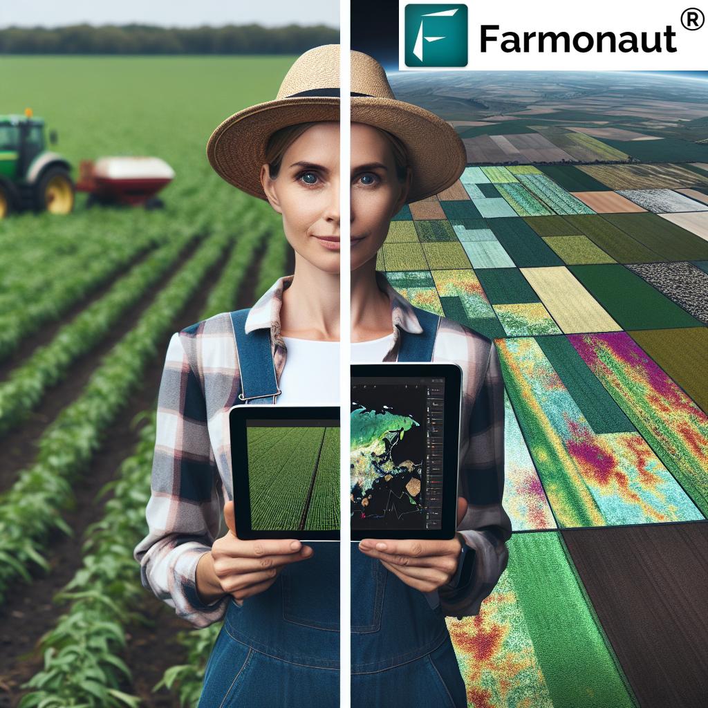
In the ever-evolving landscape of modern agriculture, we are witnessing a remarkable transformation driven by cutting-edge technologies. At the forefront of this revolution is satellite crop monitoring and data analytics, which are reshaping the way we approach farming and agricultural management. As experts in the field, we at Farmonaut are excited to explore the profound impact these innovations are having on sustainable farming practices and the future of global food production.
The Power of Satellite Crop Monitoring
Satellite crop monitoring has emerged as a game-changing tool in the agricultural sector. By harnessing the power of advanced satellite technology, farmers and agronomists can now gain unprecedented insights into their fields and crops. This revolutionary approach to crop management offers several key advantages:
- Real-time Monitoring: Satellite imagery provides up-to-date information on crop health, growth patterns, and field conditions.
- Wide Coverage: Large areas can be monitored efficiently, making it ideal for both small-scale farms and vast agricultural operations.
- Non-invasive Observation: Crops can be monitored without physical intervention, reducing the risk of damage or disturbance.
- Frequent Updates: Regular satellite passes allow for continuous monitoring throughout the growing season.
These capabilities have transformed the way we approach crop management, enabling more informed decision-making and proactive problem-solving in agriculture.
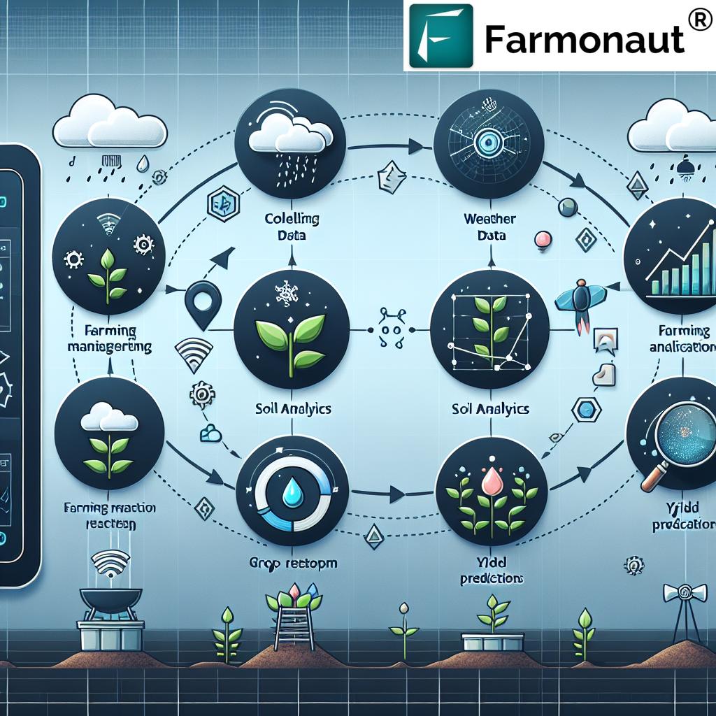
Data Analytics: Turning Information into Actionable Insights
While satellite imagery provides valuable raw data, it’s the power of advanced analytics that truly unlocks its potential. Sophisticated algorithms and machine learning models process vast amounts of satellite data, weather information, and historical records to generate actionable insights for farmers and agricultural professionals.
Key areas where data analytics is making a significant impact include:
- Crop Health Assessment: By analyzing spectral data from satellite imagery, we can detect early signs of crop stress, disease, or pest infestations.
- Yield Prediction: Combining historical yield data with current crop conditions allows for more accurate yield forecasts.
- Resource Optimization: Analytics help determine optimal irrigation schedules and fertilizer application rates, leading to more efficient use of resources.
- Risk Management: By identifying potential threats early, farmers can take preventive measures to mitigate risks to their crops.
Sustainable Farming Practices Enabled by Technology
The integration of satellite crop monitoring and data analytics is playing a crucial role in promoting sustainable farming practices. Here’s how:
- Precision Agriculture: By providing detailed insights into field variability, these technologies enable targeted interventions, reducing waste and minimizing environmental impact.
- Water Conservation: Advanced soil moisture monitoring helps optimize irrigation, conserving water resources.
- Reduced Chemical Usage: Precise detection of pest and disease outbreaks allows for targeted treatment, reducing the overall use of pesticides and herbicides.
- Carbon Footprint Reduction: Improved efficiency in farm operations leads to reduced fuel consumption and lower carbon emissions.
The Farmonaut Approach: Integrating Cutting-Edge Technology
At Farmonaut, we are at the forefront of this agricultural revolution, offering a comprehensive platform that leverages satellite crop monitoring and advanced data analytics. Our system provides farmers and agricultural professionals with the tools they need to make data-driven decisions and implement sustainable farming practices.
Here’s a comparison of traditional farming methods versus the Farmonaut system:
| Feature | Traditional Farming | Farmonaut System |
|---|---|---|
| Real-time monitoring | Limited, often manual | Continuous, satellite-based |
| Data-driven decisions | Based on experience and limited data | Informed by comprehensive analytics |
| Precision agriculture | Difficult to implement | Enabled by detailed field insights |
| Sustainability | Challenging to optimize | Enhanced through resource optimization |
| Risk management | Reactive approach | Proactive identification and mitigation |
| Yield prediction | Based on historical averages | Data-driven, more accurate forecasts |
Key Features of the Farmonaut Platform
Our platform offers a range of features designed to empower farmers and agricultural professionals:
- Satellite-Based Crop Health Monitoring: Regular updates on vegetation health indices like NDVI.
- Soil Moisture Analysis: Detailed insights into field moisture levels for optimal irrigation management.
- Weather Forecasting: Accurate, localized weather predictions to inform farming decisions.
- Yield Prediction Models: Advanced algorithms for estimating crop yields.
- Pest and Disease Detection: Early warning systems for potential outbreaks.
- Custom Field Boundaries: Ability to define and monitor specific areas of interest.
- Historical Data Analysis: Access to past data for trend analysis and long-term planning.
- Mobile App Integration: Access to insights on-the-go through our mobile applications.
To experience these features firsthand, visit our app redirect page or download our mobile app for Android or iOS.
Empowering Farmers with Data-Driven Insights
One of the most significant advantages of satellite crop monitoring and data analytics is the empowerment it brings to farmers. By providing access to detailed, timely information about their fields and crops, these technologies enable farmers to:
- Make Informed Decisions: Rather than relying solely on intuition or traditional methods, farmers can base their decisions on concrete data and scientific analysis.
- Optimize Resource Use: Precise information about crop needs allows for more efficient use of water, fertilizers, and other inputs.
- Improve Crop Quality: Early detection of issues enables timely interventions, leading to better crop quality and higher yields.
- Reduce Environmental Impact: By minimizing waste and optimizing resource use, farmers can significantly reduce their environmental footprint.
- Enhance Profitability: Improved efficiency and higher yields translate to better financial outcomes for farmers.
The Role of Remote Sensing in Modern Agriculture
Remote sensing technology, particularly through satellites, plays a crucial role in modern agricultural practices. This technology allows us to gather valuable data about crops and fields without physical contact, offering several advantages:
- Wide Area Coverage: Satellites can monitor vast agricultural areas quickly and efficiently.
- Frequent Observations: Regular satellite passes provide up-to-date information throughout the growing season.
- Multispectral Imaging: Different spectral bands can reveal various aspects of crop health and soil conditions.
- Weather-Independent: Satellite imagery can be captured regardless of local weather conditions.
- Historical Data Collection: Long-term satellite data allows for trend analysis and pattern recognition.
At Farmonaut, we leverage advanced remote sensing technologies to provide our users with the most comprehensive and accurate field insights possible.
Advancing Precision Agriculture
Precision agriculture is a farming management concept that uses detailed, site-specific information to precisely manage and optimize agricultural inputs. Satellite crop monitoring and data analytics are key enablers of this approach, allowing for:
- Variable Rate Application (VRA): Tailoring the application of fertilizers, water, and other inputs based on the specific needs of different areas within a field.
- Zone Management: Dividing fields into management zones based on soil type, topography, and other factors to optimize crop management strategies.
- Targeted Crop Protection: Applying pesticides and herbicides only where and when they are needed, reducing overall chemical use.
- Efficient Machinery Use: Optimizing the routes and operations of farm machinery to reduce fuel consumption and soil compaction.
By enabling these precision agriculture practices, satellite monitoring and data analytics contribute significantly to more sustainable and efficient farming operations.
Enhancing Crop Yield Prediction and Risk Management
Accurate yield prediction and effective risk management are critical aspects of successful farming. Our satellite-based monitoring system and advanced analytics provide powerful tools for these purposes:
- Yield Forecasting: By analyzing current crop conditions, historical data, and weather patterns, we can provide more accurate yield predictions.
- Early Warning Systems: Our platform can detect early signs of crop stress, disease, or pest infestations, allowing for timely interventions.
- Weather Risk Assessment: Advanced weather forecasting helps farmers prepare for and mitigate potential weather-related risks.
- Market Intelligence: Yield predictions on a larger scale can provide valuable insights for market planning and price forecasting.
These capabilities not only help individual farmers optimize their operations but also contribute to broader food security and market stability.
Sustainable Water Management in Agriculture
Water scarcity is a growing concern in many agricultural regions, making efficient water management crucial for sustainable farming. Our satellite-based monitoring system offers innovative solutions for water conservation:
- Soil Moisture Monitoring: Satellite data provides insights into soil moisture levels across entire fields, helping optimize irrigation schedules.
- Evapotranspiration Mapping: By analyzing vegetation indices and weather data, we can estimate crop water requirements more accurately.
- Irrigation Efficiency Analysis: Our system can identify areas of over- or under-irrigation, allowing for targeted improvements in water distribution.
- Drought Monitoring: Early detection of drought conditions enables proactive measures to mitigate crop stress.
Through these advanced water management techniques, farmers can significantly reduce water waste while maintaining or even improving crop yields.
The Impact on Agricultural Insurance and Finance
Satellite crop monitoring and data analytics are also transforming the agricultural insurance and finance sectors. These technologies provide more accurate and timely information, benefiting both farmers and financial institutions:
- Risk Assessment: Insurers can more accurately assess crop risks based on real-time and historical data.
- Claims Processing: Satellite imagery can quickly verify crop damage claims, speeding up the claims process.
- Loan Evaluation: Banks can use crop health and yield prediction data to assess loan applications more effectively.
- Performance Monitoring: Financial institutions can track the performance of agricultural investments using satellite-based crop monitoring.
These applications help create a more stable and efficient agricultural finance ecosystem, benefiting farmers, insurers, and lenders alike.
Advancing Organic and Sustainable Farming Practices
Organic farming and other sustainable agricultural practices are gaining importance as consumers become more environmentally conscious. Satellite crop monitoring and data analytics play a crucial role in supporting these practices:
- Pest and Disease Management: Early detection of pest infestations or diseases allows for targeted organic treatments, reducing the need for broad-spectrum pesticides.
- Soil Health Monitoring: Satellite data can provide insights into soil organic matter content and overall soil health, crucial for organic farming.
- Crop Rotation Planning: Historical field data helps optimize crop rotation strategies for better soil management and pest control.
- Biodiversity Assessment: Satellite imagery can help monitor and promote biodiversity in and around agricultural areas.
By providing detailed insights into field conditions and crop health, our technology empowers farmers to implement and maintain sustainable farming practices more effectively.
The Future of Agriculture: AI and Machine Learning
As we look to the future, artificial intelligence (AI) and machine learning are set to play an even more significant role in agricultural data analytics. At Farmonaut, we are continuously developing and integrating these advanced technologies to enhance our platform:
- Predictive Analytics: AI models can predict crop yields, pest outbreaks, and market trends with increasing accuracy.
- Automated Crop Classification: Machine learning algorithms can automatically identify and classify different crop types from satellite imagery.
- Personalized Recommendations: AI-driven systems can provide tailored recommendations for each farm based on its unique characteristics and historical performance.
- Anomaly Detection: Advanced algorithms can quickly identify unusual patterns in crop growth or field conditions, alerting farmers to potential issues.
These AI and machine learning capabilities will further enhance the power of satellite crop monitoring, providing even more valuable insights to farmers and agricultural professionals.
Integrating Satellite Data with Other Technologies
While satellite crop monitoring is a powerful tool on its own, its effectiveness is amplified when integrated with other agricultural technologies. At Farmonaut, we focus on creating a comprehensive ecosystem that combines various data sources and technologies:
- IoT Sensors: Integrating ground-based sensors with satellite data provides a more complete picture of field conditions.
- Drone Imagery: High-resolution drone imagery can complement satellite data for more detailed analysis of specific areas.
- Weather Stations: Local weather data enhances the accuracy of our crop models and predictions.
- Farm Management Software: Integrating our satellite insights with farm management systems creates a seamless workflow for farmers.
This integrated approach ensures that farmers have access to the most comprehensive and accurate information possible to guide their decision-making.
The Global Impact of Satellite Crop Monitoring
The adoption of satellite crop monitoring and data analytics is having a significant impact on global agriculture and food security:
- Increased Food Production: By optimizing farming practices, these technologies contribute to higher yields and increased global food production.
- Climate Change Adaptation: Satellite data helps farmers adapt to changing climate patterns and extreme weather events.
- Resource Conservation: Precision agriculture enabled by satellite monitoring leads to more efficient use of water, fertilizers, and other resources.
- Reduced Environmental Impact: By minimizing the use of chemicals and optimizing resource use, these technologies help reduce agriculture’s environmental footprint.
- Support for Smallholder Farmers: Accessible satellite-based solutions help smallholder farmers in developing countries improve their productivity and resilience.
Through these impacts, satellite crop monitoring and data analytics are playing a crucial role in creating a more sustainable and secure global food system.
Customizing Solutions for Different Agricultural Sectors
At Farmonaut, we understand that different agricultural sectors have unique needs and challenges. Our platform is designed to be flexible and customizable to meet these diverse requirements:
- Row Crops: Optimized for large-scale monitoring of crops like wheat, corn, and soybeans.
- Orchards and Vineyards: Specialized analysis for tree crops and grapevines, including canopy health assessment.
- Greenhouse Production: Integration with greenhouse management systems for indoor crop monitoring.
- Pasture Management: Tools for assessing grazing land health and productivity.
- Aquaculture: Monitoring of water bodies for fish farming operations.
By tailoring our solutions to specific agricultural sectors, we ensure that all farmers can benefit from the power of satellite crop monitoring and data analytics.
Empowering Agricultural Research and Development
Satellite crop monitoring and data analytics are not just tools for farmers; they also play a crucial role in agricultural research and development:
- Crop Breeding Programs: Satellite data helps researchers evaluate new crop varieties under different environmental conditions.
- Climate Change Studies: Long-term satellite observations provide valuable data for studying the impact of climate change on agriculture.
- Soil Health Research: Satellite-based soil analysis contributes to our understanding of soil dynamics and health.
- Ecosystem Services Assessment: Researchers can study the interaction between agricultural lands and surrounding ecosystems.
By providing researchers with access to vast amounts of agricultural data, satellite monitoring accelerates scientific progress in agriculture and related fields.
The Role of Satellite Constellations in Agriculture
The effectiveness of satellite crop monitoring relies heavily on the capabilities of satellite constellations. At Farmonaut, we leverage data from multiple satellite constellations to provide comprehensive coverage and frequent updates:
- Optical Satellites: Provide high-resolution visible and near-infrared imagery for detailed crop analysis.
- Radar Satellites: Offer all-weather monitoring capabilities, particularly useful for soil moisture assessment.
- Hyperspectral Satellites: Provide detailed spectral information for advanced crop health analysis.
- Nanosatellites: Emerging technology offering more frequent revisit times and potentially lower-cost data.
By combining data from these various satellite types, we can provide farmers with the most comprehensive and up-to-date information about their fields.
Addressing Challenges in Satellite Crop Monitoring
While satellite crop monitoring offers numerous benefits, it also comes with certain challenges that we at Farmonaut are continually working to address:
- Cloud Cover: Optical satellites can be hindered by cloud cover. We use advanced algorithms and integrate radar satellite data to mitigate this issue.
- Data Processing Complexity: Handling vast amounts of satellite data requires sophisticated processing capabilities. Our advanced analytics platform is designed to efficiently process and analyze this data.
- Interpretation of Results: Satellite data can be complex to interpret. We provide user-friendly interfaces and clear visualizations to make the information accessible to all users.
- Integration with Existing Systems: To ensure seamless adoption, we offer APIs and integration tools to connect our platform with existing farm management systems.
By addressing these challenges, we ensure that satellite crop monitoring remains an effective and accessible tool for farmers of all scales.
The Economic Benefits of Satellite Crop Monitoring
Implementing satellite crop monitoring and data analytics can have significant economic benefits for farmers and the agricultural sector as a whole:
- Increased Crop Yields: Optimized farming practices lead to higher and more consistent yields.
- Reduced Input Costs: Precision application of water, fertilizers, and pesticides results in lower input costs.
- Improved Labor Efficiency: Targeted interventions and automated monitoring reduce labor requirements.
- Better Risk Management: Early problem detection and accurate yield predictions help manage financial risks.
- Access to Premium Markets: Data-driven farming practices can help meet the requirements for premium or certified products.
These economic benefits make satellite crop monitoring a valuable investment for farmers looking to improve their profitability and sustainability.
Satellite Crop Monitoring and Food Traceability
In an era where consumers are increasingly concerned about the origin and quality of their food, satellite crop monitoring plays a crucial role in enhancing food traceability:
- Field-to-Fork Tracking: Satellite data provides a verifiable record of crop growth and management practices.
- Certification Support: Detailed field data helps farmers meet and demonstrate compliance with various certification standards.
- Supply Chain Transparency: Integrating satellite data into supply chain management systems enhances overall transparency.
- Quality Assurance: Monitoring crop health throughout the growing season contributes to better quality control.
By supporting robust traceability systems, satellite crop monitoring helps build consumer trust and supports the development of more sustainable food systems.
Farmonaut’s Commitment to Continuous Innovation
At Farmonaut, we are committed to staying at the forefront of agricultural technology. Our ongoing research and development efforts focus on:
- Enhancing AI Capabilities: Developing more sophisticated AI models for crop analysis and prediction.
- Expanding Satellite Data Sources: Integrating data from new satellite constellations as they become available.
- Improving User Experience: Continuously refining our platform to make it more intuitive and user-friendly.
- Developing New Analytics Tools: Creating innovative ways to analyze and visualize agricultural data.
- Fostering Partnerships: Collaborating with research institutions and industry partners to drive innovation in agricultural technology.
Through these efforts, we aim to continuously enhance the value we provide to farmers and the agricultural community.
The Role of Satellite Crop Monitoring in Climate-Smart Agriculture
Climate-smart agriculture aims to increase productivity while adapting to and mitigating the effects of climate change. Satellite crop monitoring is a key enabler of this approach:
- Climate Adaptation: Satellite data helps farmers adapt their practices to changing climate patterns.
- Carbon Sequestration Monitoring: Satellite imagery can track changes in soil organic matter, supporting carbon sequestration efforts.
- Greenhouse Gas Emission Reduction: Optimized resource use leads to reduced emissions from agricultural activities.
- Biodiversity Conservation: Satellite monitoring helps in implementing farming practices that support biodiversity.
By supporting climate-smart agriculture, satellite crop monitoring contributes to the long-term sustainability of our food systems.
Empowering the Next Generation of Farmers
As we look to the future of agriculture, it’s crucial to empower the next generation of farmers with the tools and knowledge they need to succeed. Satellite crop monitoring and data analytics play a vital role in this:
- Education and Training: Our platform serves as an educational tool, helping young farmers understand advanced agricultural concepts.
- Tech-Driven Farming: By making advanced technology accessible, we attract tech-savvy individuals to agriculture.
- Data-Driven Decision Making: We help cultivate a culture of data-driven decision making among new farmers.
- Sustainable Practices: Our tools support the implementation of sustainable farming practices, aligning with the values of many young farmers.
By providing these capabilities, we aim to support the development of a skilled, tech-savvy, and sustainability-focused next generation of farmers.
Frequently Asked Questions (FAQ)
Q: What is satellite crop monitoring?
A: Satellite crop monitoring is the use of satellite imagery and data to observe and analyze crop health, growth patterns, and field conditions over large areas.
Q: How does satellite crop monitoring benefit farmers?
A: It provides real-time insights into crop health, enables precise resource management, helps in early detection of issues, and supports data-driven decision making.
Q: Can satellite monitoring work for small farms?
A: Yes, our platform is designed to be scalable and can provide valuable insights for farms of all sizes.
Q: How often is satellite data updated?
A: The frequency of updates depends on the satellite constellation used, but typically ranges from daily to weekly.
Q: Is specialized equipment needed to use satellite crop monitoring?
A: No, our platform is accessible through web and mobile applications, requiring only an internet-connected device.
Q: How accurate is satellite-based crop health assessment?
A: Modern satellite technology, combined with advanced analytics, provides highly accurate crop health assessments, often validated through ground-truthing.
Q: Can satellite monitoring help with irrigation management?
A: Yes, satellite-based soil moisture analysis and evapotranspiration mapping are powerful tools for optimizing irrigation.
Q: How does satellite monitoring contribute to sustainable farming?
A: It enables precise resource management, reduces waste, and supports practices that minimize environmental impact.
Q: Is satellite data affected by weather conditions?
A: Optical satellite imagery can be affected by cloud cover, but we use various techniques and data sources to mitigate this issue.
Q: How can I get started with satellite crop monitoring?
A: You can start by visiting our app redirect page or downloading our mobile app to explore our platform.
Conclusion: The Future of Agriculture is Here
As we’ve explored throughout this article, satellite crop monitoring and data analytics are revolutionizing the agricultural industry. These technologies are not just improving productivity and efficiency; they’re paving the way for a more sustainable, resilient, and data-driven approach to farming.
At Farmonaut, we’re proud to be at the forefront of this agricultural revolution. Our platform brings the power of satellite technology and advanced analytics to farmers of all scales, empowering them to make informed decisions, optimize their operations, and contribute to a more sustainable food system.
As we look to the future, we see endless possibilities for further innovation and improvement in agricultural technology. From AI-driven predictive analytics to integration with emerging technologies like IoT and blockchain, the potential for advancement is immense.
We invite you to join us on this exciting journey towards the future of agriculture. Whether you’re a farmer looking to optimize your operations, a researcher exploring new frontiers in agricultural science, or an industry professional seeking to leverage cutting-edge technology, Farmonaut is here to support you.
Explore our platform, experience the power of satellite crop monitoring, and discover how data-driven insights can transform your approach to agriculture. Together, we can build a more sustainable, productive, and resilient agricultural sector for generations to come.
Ready to get started? Visit our app redirect page or download our mobile app for Android or iOS today. For developers interested in integrating our powerful satellite and weather data into their own applications, check out our API and API documentation.
Join us in revolutionizing agriculture with satellite crop monitoring and data analytics. The future of farming is here, and it’s more exciting than ever.