🌾 Introduction to Satellite Imaging in Agriculture
The agricultural technology (AgTech) industry is experiencing a revolution, with satellite imaging playing a pivotal role in transforming farming practices. For agriculture technology iOS development agencies and iOS development firms specializing in the agriculture technology industry, understanding and leveraging satellite data is crucial. This comprehensive guide will explore how to develop an iOS app for the AgTech industry that utilizes satellite imagery analysis to enhance farming analytics and decision-making.
Satellite imagery for agriculture provides invaluable insights into crop health, irrigation needs, and overall field conditions. By integrating this technology into iOS applications, developers can create powerful tools for farmers and agricultural managers to optimize their operations.
🛰️ Understanding Satellite Data Acquisition
The foundation of any robust iOS app for the AgTech industry lies in its ability to acquire and process satellite data effectively. Let’s delve into the key concepts and API endpoints that make this possible.
Sense Days: The Cornerstone of Satellite Data
“Sense days” refer to the specific dates when satellites capture images of agricultural fields. These are crucial for obtaining timely and accurate data about crop conditions.
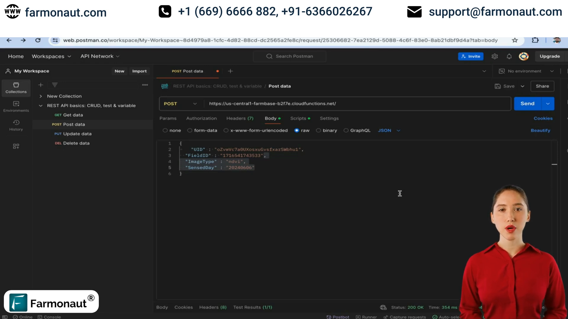
Using the getSenseDays Endpoint
To retrieve sense days, use the getSenseDays API endpoint. This requires passing the following parameters:
- uid: User identification
- field_id: Unique identifier for the agricultural field
- polygon_id: Optional parameter for specific area within a field
The response will include:
- Sense day dates
- Crop red zones
- Irrigation red zones
- Weather conditions (cloudy or clear)
Handling Cloudy Conditions with SAR Data
When traditional satellite imagery is obscured by clouds, Synthetic Aperture Radar (SAR) data becomes invaluable. SAR can penetrate cloud cover, ensuring continuous data availability.
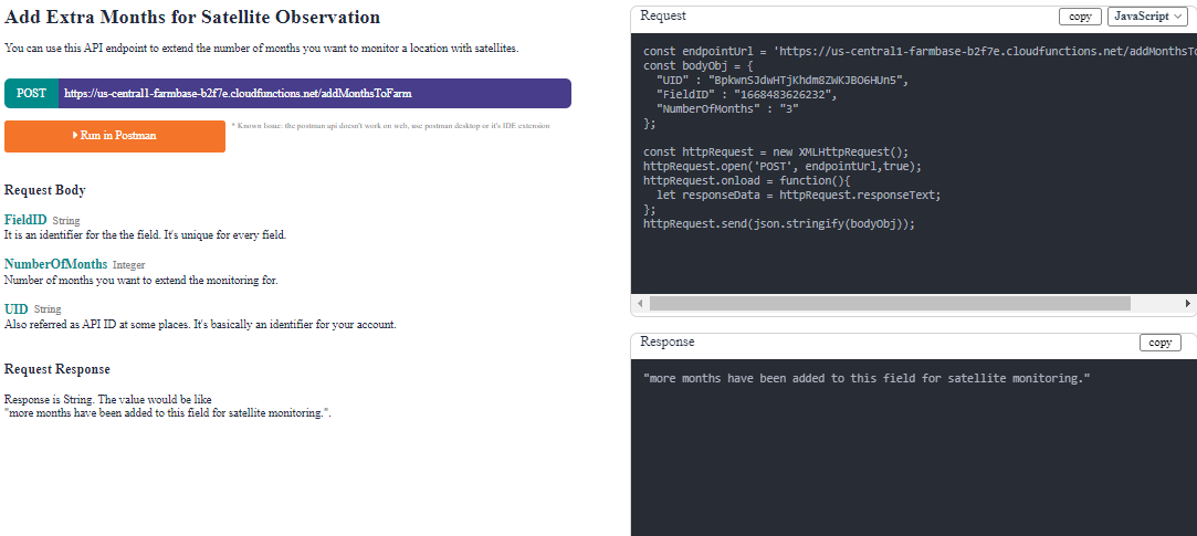
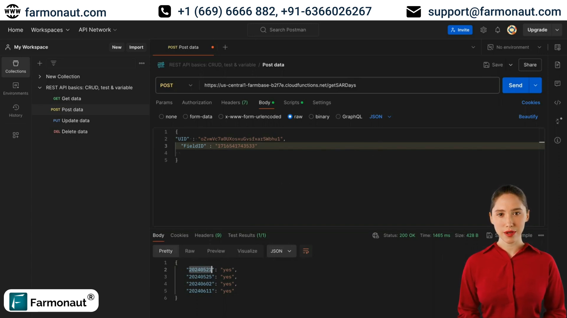
Implementing the getSARDays Endpoint
To fetch SAR data dates, use the getSARDays endpoint. This requires:
- uid: User identification
- field_id: Field identifier
Implementing an algorithm to dynamically switch between regular satellite data and SAR data based on weather conditions can significantly enhance your app’s reliability and usefulness.
📊 Retrieving and Analyzing Satellite Images
Once you have the sense days or SAR days, the next step is to fetch and analyze the actual satellite images. This is where the power of satellite imagery analysis truly comes into play for farming analytics.
Fetching Field Images
Use the getFieldImage endpoint to retrieve specific satellite images. Parameters include:
- uid: User ID
- field_id: Field identifier
- image_type: e.g., NDVI, RVI, RSM
- sense_date: Date of the satellite visit
- color_map: Optional parameter for image coloration
The response will be a URL to the requested image.
Analyzing Index Values
To break down and analyze specific index values over time, use these endpoints:
getFieldIndexBreakdown
This endpoint provides a detailed breakdown of index values (e.g., NDVI) across different ranges for a specific field and date.
getIndexValue
Use this to fetch the value of a particular index on a specific date.
getAllIndexValues
This comprehensive endpoint retrieves values for all available indices across all dates for a given field.
📱 Integrating Satellite Data into Your iOS App
When developing an iOS app for the AgTech industry, it’s crucial to present satellite data in an intuitive and actionable format. Here are some key considerations:
User Interface Design
Design your app’s interface to clearly display satellite images and data visualizations. Consider using:
- Interactive maps to showcase field imagery
- Graphs and charts for trend analysis
- Color-coded overlays to highlight areas of concern
Data Processing and Storage
Implement efficient data processing algorithms to handle large volumes of satellite data. Consider using Core Data for local storage and caching to improve app performance.
Real-time Updates
Integrate push notifications to alert users about new satellite data or significant changes in field conditions.
🔍 Advanced Features for AgTech iOS Apps
To create a truly comprehensive iOS app for the AgTech industry, consider implementing these advanced features:
Machine Learning Integration
Utilize Core ML to develop predictive models for crop yield, pest outbreaks, or optimal harvesting times based on historical satellite data.
Augmented Reality (AR) Field Visualization
Implement AR features that allow users to visualize satellite data overlaid on real-world field views through their device’s camera.
Offline Mode
Develop robust offline functionality to ensure that critical data and features are available even in areas with poor internet connectivity.
📊 Leveraging Farming Analytics
Integrating farming analytics into your iOS app can provide immense value to users in the AgTech industry. Here’s how to make the most of the data:
Trend Analysis
Implement algorithms to analyze long-term trends in crop health, water usage, and yield based on historical satellite data.
Comparative Analytics
Allow users to compare current field conditions with historical data or benchmark against similar farms in the region.
Predictive Insights
Use machine learning models to provide predictive insights on potential issues or opportunities, such as early detection of crop diseases or optimal fertilization timing.
| Metric | Current Field | Regional Average | Difference |
|---|---|---|---|
| NDVI | 0.72 | 0.68 | +5.9% |
| Water Stress Index | 0.31 | 0.35 | -11.4% |
| Estimated Yield (t/ha) | 4.2 | 3.9 | +7.7% |
🔐 Ensuring Data Security and Compliance
When developing an iOS app for the AgTech industry that handles sensitive satellite data, it’s crucial to prioritize security and compliance:
Data Encryption
Implement strong encryption protocols for data transmission and storage to protect sensitive agricultural information.
User Authentication
Use robust authentication methods, such as two-factor authentication, to ensure only authorized users can access the app’s features and data.
Compliance with Agricultural Regulations
Ensure your app complies with relevant agricultural data privacy laws and regulations in the regions where it will be used.

❓ FAQ: iOS App Development for AgTech Industry
Q: What are the key benefits of using satellite imagery in agriculture?
A: Satellite imagery provides valuable insights into crop health, water stress, pest infestations, and overall field conditions, enabling more informed decision-making and improved resource management.
Q: How often is satellite data updated?
A: Satellite visits typically occur every 3-5 days, depending on the location. However, this can vary based on weather conditions and satellite availability.
Q: Can satellite data be used in areas with frequent cloud cover?
A: Yes, by utilizing Synthetic Aperture Radar (SAR) data, which can penetrate clouds, it’s possible to obtain field information even in cloudy conditions.
Q: What programming languages and frameworks are best for developing AgTech iOS apps?
A: Swift is the primary language for iOS development. Frameworks like Core ML for machine learning, MapKit for mapping features, and Core Data for data management are particularly useful for AgTech apps.
Q: How can I ensure my AgTech iOS app remains performant while handling large amounts of satellite data?
A: Implement efficient data caching strategies, use background processing for heavy computations, and optimize image loading and rendering to maintain app performance.
🎯 Conclusion
Developing an iOS app for the AgTech industry that leverages satellite imagery analysis and farming analytics can significantly enhance agricultural management and decision-making. By integrating powerful API endpoints for retrieving and analyzing satellite data, implementing advanced features like machine learning and AR, and ensuring robust data security, you can create a valuable tool for the modern farmer.
As an agriculture technology iOS development agency or an iOS development firm specializing in the agriculture technology industry, embracing these technologies and methodologies will position you at the forefront of the AgTech revolution. The future of farming is digital, and your iOS app can play a crucial role in shaping that future.
Remember, the key to success lies in creating an intuitive, powerful, and reliable application that translates complex satellite data into actionable insights for farmers and agricultural managers. By focusing on user needs and leveraging the latest in iOS development and satellite technology, you can create an app that truly makes a difference in the world of agriculture.