Revolutionizing Agriculture: How Satellite Crop Monitoring and Precision Farming Boost Yields and Sustainability
“Satellite crop monitoring can increase agricultural yields by up to 20% while reducing water usage by 30%, according to recent studies.”
In the ever-evolving landscape of modern agriculture, we find ourselves at the cusp of a technological revolution that promises to transform the way we grow food and manage our precious natural resources. At the heart of this revolution lies the powerful combination of satellite crop monitoring and precision farming techniques. As representatives of Farmonaut, we’re excited to explore how these cutting-edge technologies are reshaping the agricultural industry, empowering farmers with data-driven insights, and paving the way for a more sustainable future.
The Dawn of Satellite-Enabled Precision Agriculture
Precision agriculture, powered by satellite technology, is revolutionizing the way we approach farming. By harnessing the power of satellite imagery, coupled with advanced data analytics, we can now gain unprecedented insights into crop health, soil conditions, and potential yields. This transformation is not just about implementing new technologies; it’s about fundamentally changing our approach to farm management and decision-making processes.

The Power of Satellite Crop Monitoring
Satellite crop monitoring is at the forefront of this agricultural revolution. By utilizing advanced remote sensing technologies, we can now observe vast swaths of agricultural land with unprecedented detail and frequency. Here’s how it works:
- High-Resolution Imagery: Satellites like Landsat and Sentinel provide high-resolution images of agricultural areas, allowing us to detect even subtle changes in crop health and field conditions.
- Multispectral Analysis: By analyzing different wavelengths of light reflected from crops, we can assess various aspects of plant health, including chlorophyll content and water stress.
- Frequent Monitoring: With regular satellite passes, we can monitor crop development throughout the growing season, enabling timely interventions when issues arise.
This constant stream of data from space provides farmers with a bird’s-eye view of their fields, enabling them to make informed decisions about irrigation, fertilization, and pest control with pinpoint accuracy.
Precision Farming: Where Satellite Data Meets Ground Truth
Precision farming techniques take the insights gained from satellite monitoring and translate them into actionable strategies on the ground. This approach combines satellite data with information from various sources, including:
- Ground Sensors: Soil moisture probes and weather stations provide real-time data on local conditions.
- Drone Imagery: Unmanned aerial vehicles offer high-resolution, on-demand imagery to complement satellite data.
- GPS-Guided Equipment: Tractors and other farm machinery use precise location data to optimize planting, spraying, and harvesting operations.
By integrating these diverse data sources, precision farming allows for highly targeted interventions, optimizing resource use and maximizing crop yields.
The Role of Artificial Intelligence in Agricultural Data Analytics
Agricultural data analytics, powered by artificial intelligence (AI) and machine learning algorithms, is the engine that drives the precision farming revolution. These advanced technologies enable us to:
- Predict Crop Yields: By analyzing historical data and current conditions, AI models can forecast harvest outcomes with increasing accuracy.
- Detect Crop Stress: Machine learning algorithms can identify early signs of pest infestations, disease outbreaks, or nutrient deficiencies before they become visible to the human eye.
- Optimize Resource Allocation: AI-driven recommendations help farmers determine the optimal amount of water, fertilizer, and pesticides to apply to each part of their fields.
These capabilities transform raw data into actionable insights, empowering farmers to make data-driven decisions that improve efficiency and sustainability.

Advancing Crop Classification and Field Boundary Mapping
“AI-powered crop classification algorithms can identify over 100 different crop types with 95% accuracy using high-resolution satellite imagery.”
One of the most significant advancements in satellite-based agriculture is the development of sophisticated crop classification techniques. Using machine learning algorithms and high-resolution satellite imagery, we can now:
- Accurately identify and map different crop types across vast areas
- Monitor crop rotations and land use changes over time
- Assess crop health and estimate yields for specific varieties
Similarly, field boundary mapping has been revolutionized by satellite technology. Precise field delineation allows for:
- Improved land management and resource allocation
- More accurate area calculations for subsidy programs and insurance claims
- Better planning for crop rotation and conservation efforts
These advancements in crop classification and field mapping are crucial for both individual farmers and policymakers, providing a comprehensive view of agricultural landscapes and enabling more informed decision-making at all levels.
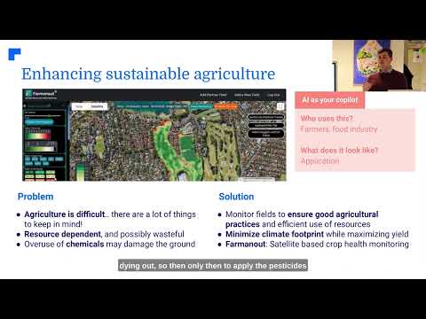
Enhancing Sustainability Through Precision Agriculture
One of the most compelling aspects of satellite-enabled precision farming is its potential to promote sustainable agriculture. By optimizing resource use and minimizing waste, these technologies help reduce agriculture’s environmental footprint in several ways:
- Water Conservation: Precision irrigation systems, guided by satellite and ground sensor data, can reduce water usage by up to 30% while maintaining or improving crop yields.
- Reduced Chemical Use: Targeted application of fertilizers and pesticides minimizes runoff and soil degradation.
- Carbon Sequestration: Improved soil management practices, informed by satellite data, can increase soil organic carbon content, helping to mitigate climate change.
- Biodiversity Protection: Precise mapping of agricultural areas helps in preserving natural habitats and wildlife corridors.
These sustainability benefits not only help protect the environment but also contribute to long-term farm profitability by preserving soil health and reducing input costs.
Farmonaut: Bringing Satellite Crop Monitoring to Every Farmer
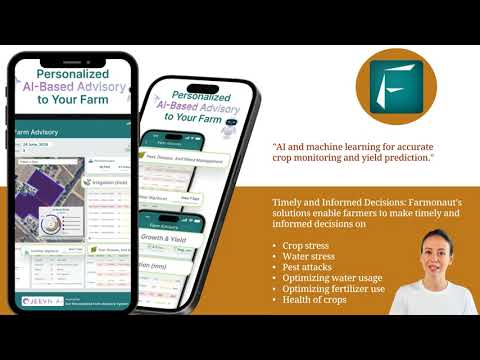
At Farmonaut, we’re committed to making the benefits of satellite crop monitoring and precision farming accessible to farmers of all scales. Our platform integrates cutting-edge satellite technology with user-friendly interfaces, providing:
- Real-time crop health monitoring
- AI-powered advisory systems
- Precision resource management tools
- Weather analytics for improved decision-making
By democratizing access to these advanced technologies, we’re helping farmers around the world boost their yields, reduce costs, and adopt more sustainable practices.

The Future of Farming: Integrating Satellite Data with On-Ground Expertise
As we look to the future of agriculture, it’s clear that the integration of satellite-based crop monitoring with traditional farming knowledge will be key to addressing global food security challenges. This fusion of technology and expertise enables:
- Proactive Risk Management: Early detection of crop stress or potential yield issues allows for timely interventions.
- Optimized Resource Allocation: Precision application of inputs based on real-time crop needs improves efficiency and reduces waste.
- Data-Driven Decision Making: Comprehensive analytics empower farmers to make informed choices about planting, harvesting, and crop management.
By leveraging these advanced tools, farmers can not only increase their productivity but also adapt more effectively to changing climate conditions and market demands.
Evolving Agricultural Insurance with Geospatial Intelligence
The integration of satellite technology is also transforming the agricultural insurance sector. Geospatial intelligence provides insurers with unprecedented capabilities for risk assessment and claims verification:
- Accurate Risk Pricing: Satellite data allows for more precise evaluation of field conditions and potential risks, leading to fairer premium calculations.
- Rapid Claim Processing: In the event of crop damage due to weather events or other factors, satellite imagery can quickly verify claims, speeding up the payout process.
- Fraud Prevention: The ability to monitor crops throughout the growing season helps insurers detect and prevent fraudulent claims.
These advancements in agricultural insurance not only benefit insurers but also provide farmers with more reliable and affordable coverage options, enhancing their financial security.
Weather Analytics: The Key to Improved Crop Yield Predictions
Weather analytics plays a crucial role in modern precision agriculture. By combining satellite observations with advanced meteorological models, we can:
- Provide highly localized weather forecasts for individual fields
- Predict extreme weather events with greater accuracy and lead time
- Model the impact of weather patterns on crop development and yield potential
This enhanced weather intelligence allows farmers to make proactive decisions about planting dates, irrigation schedules, and harvest timing, ultimately leading to improved yields and reduced crop losses.
Harvest Monitoring Systems: Optimizing the Final Stage
Harvest monitoring systems represent the culmination of precision farming efforts. These systems integrate satellite data with on-ground sensors and GPS-enabled harvesting equipment to:
- Optimize harvest timing for peak crop quality and yield
- Guide harvesting equipment for maximum efficiency
- Provide real-time yield mapping for immediate insights
By fine-tuning the harvest process, farmers can maximize their returns and minimize post-harvest losses, ensuring that the benefits of precision agriculture extend right through to the final stage of production.
Comparing Traditional Farming with Satellite-Enabled Precision Farming
To fully appreciate the transformative power of satellite crop monitoring and precision farming, let’s compare these modern techniques with traditional farming methods:
| Aspect | Traditional Farming | Farmonaut Satellite System |
|---|---|---|
| Crop Monitoring Frequency | Weekly/Monthly manual inspections | Daily satellite imagery updates |
| Field Coverage | Limited by manual field walks | Comprehensive satellite view of entire fields |
| Data Accuracy | Subjective human observations | AI-powered analysis of multispectral data |
| Resource Optimization | Uniform application of inputs | Precision application based on real-time needs |
| Yield Prediction | Based on historical averages and experience | AI-driven forecasts using current data and trends |
| Sustainability Impact | Potential overuse of water and chemicals | Optimized resource use, reduced environmental impact |
This comparison clearly demonstrates the advantages of Farmonaut’s satellite-enabled precision farming approach, highlighting improvements in efficiency, accuracy, and sustainability across all aspects of farm management.
Embracing the Future with Farmonaut
As we’ve explored throughout this article, the integration of satellite crop monitoring and precision farming techniques represents a monumental leap forward in agricultural practices. At Farmonaut, we’re proud to be at the forefront of this revolution, providing farmers with the tools they need to thrive in an increasingly complex and challenging environment.
Our commitment to making these advanced technologies accessible and affordable means that farmers of all scales can benefit from:
- Real-time crop health monitoring
- Precision resource management
- AI-powered advisory systems
- Advanced weather analytics
- Sustainable farming practices
By embracing these innovations, farmers can not only increase their yields and profitability but also play a crucial role in building a more sustainable and food-secure future for all.

Getting Started with Farmonaut
Ready to revolutionize your farming practices with satellite crop monitoring and precision agriculture? Farmonaut offers a range of solutions to meet your needs:
- Web Application: Access our powerful satellite monitoring tools from any device with an internet connection.
- Mobile Apps: Stay connected to your fields on the go with our Android and iOS applications.
- API Integration: For developers and businesses looking to incorporate our satellite and weather data into their own systems.
Explore our offerings and start your journey towards more efficient, sustainable, and profitable farming today:


For developers interested in integrating our satellite and weather data into their applications, check out our API and API Developer Docs.
Farmonaut Subscription Plans
Choose the plan that best fits your needs and start transforming your agricultural practices today:
Frequently Asked Questions
Q: How accurate is satellite crop monitoring?
A: Modern satellite crop monitoring systems can achieve very high levels of accuracy, often detecting crop health issues and yield variations with precision of up to 95% or higher, depending on the specific application and satellite resolution.
Q: Can satellite monitoring replace on-ground inspections entirely?
A: While satellite monitoring significantly reduces the need for frequent manual inspections, it’s best used in conjunction with targeted on-ground verification. This combined approach ensures the highest level of accuracy and allows for immediate action when issues are detected.
Q: How often is satellite data updated?
A: The frequency of satellite data updates can vary depending on the satellite system used. Many modern systems provide daily updates, while some high-resolution satellites may have a revisit time of a few days.
Q: Is precision farming only suitable for large-scale operations?
A: No, precision farming techniques can benefit farms of all sizes. While large operations may implement more extensive systems, even small farms can take advantage of satellite monitoring and precision agriculture tools to optimize their practices and improve yields.
Q: How does weather data integration improve farming decisions?
A: Integrated weather data allows farmers to make more informed decisions about planting, irrigation, and harvest timing. It also helps in predicting and mitigating weather-related risks, ultimately leading to better crop management and improved yields.
Conclusion
The integration of satellite crop monitoring and precision farming techniques represents a paradigm shift in agriculture, offering unprecedented opportunities for efficiency, sustainability, and profitability. As we’ve explored throughout this article, these technologies empower farmers with data-driven insights, enabling them to make informed decisions that optimize resource use and maximize yields.
At Farmonaut, we’re committed to making these advanced agricultural technologies accessible to farmers worldwide. By harnessing the power of satellite imagery, AI-driven analytics, and on-ground expertise, we’re helping to shape a future where farming is not only more productive but also more sustainable and resilient in the face of global challenges.
As we continue to innovate and refine our satellite crop monitoring and precision farming solutions, we invite you to join us on this exciting journey towards a smarter, more sustainable agricultural future. Together, we can revolutionize farming practices, ensure food security, and build a more prosperous and environmentally responsible world for generations to come.