Revolutionize Your Farm: How Satellite Crop Monitoring and GIS Technology Boost Yields and Reduce Costs
“Satellite crop monitoring can analyze up to 5 key crop health indicators simultaneously, enhancing precision agriculture efficiency.”
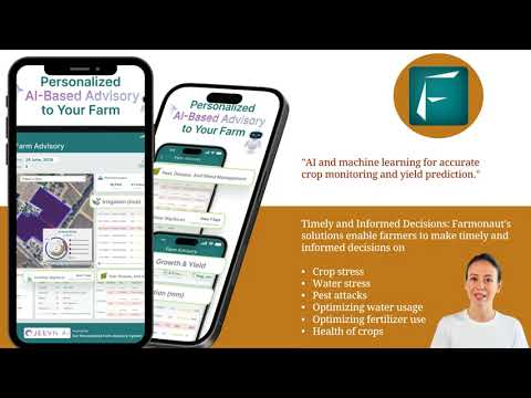
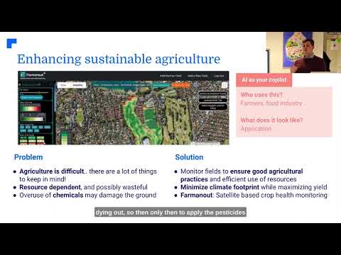
Welcome to the future of farming! At Farmonaut, we’re excited to share how precision agriculture technology and satellite crop monitoring are transforming the agricultural landscape. In this comprehensive guide, we’ll explore how our innovative solutions are helping farmers like you maximize yields, reduce costs, and embrace sustainable practices.
The Power of GIS in Agriculture
Geographic Information Systems (GIS) have revolutionized the way we approach farming. By integrating spatial data with agricultural practices, GIS technology enables farmers to make more informed decisions about their crops and land management.
- Accurate field mapping
- Soil composition analysis
- Crop rotation planning
- Resource allocation optimization
Our farm management software leverages GIS to provide you with detailed insights into your farm’s layout, soil health, and crop performance. This technology forms the backbone of precision farming, allowing for targeted interventions and optimized resource use.

Remote Sensing: Your Eyes in the Sky
Remote sensing for farming has opened up new possibilities for crop management. By utilizing satellite imagery and drone technology, we can gather crucial data about your fields without setting foot on them. This approach offers several advantages:
- Non-invasive monitoring
- Large-scale coverage
- Frequent data collection
- Early problem detection
Our satellite-based solutions provide you with regular updates on crop health, allowing for timely interventions and proactive management strategies.
NDVI Crop Mapping: The Key to Understanding Crop Health
One of the most powerful tools in our arsenal is NDVI crop mapping. NDVI (Normalized Difference Vegetation Index) is a measure of plant health based on how plants reflect different wavelengths of light. Our advanced algorithms process satellite imagery to generate NDVI maps, giving you a clear picture of your crop’s vigor across your entire field.
- Identify areas of stress
- Monitor crop growth stages
- Detect nutrient deficiencies
- Optimize harvest timing
By regularly analyzing NDVI data, you can make informed decisions about irrigation, fertilization, and pest control, ensuring your crops receive exactly what they need, when they need it.

Drone Technology: Precision from Above
Drone technology in agriculture complements our satellite-based solutions by providing high-resolution imagery and data collection capabilities. Drones equipped with multispectral cameras can capture detailed information about your crops, including:
- Plant count and spacing
- Weed identification
- Disease hotspots
- Microclimate analysis
This level of detail allows for highly targeted interventions, reducing the need for broad-spectrum treatments and minimizing environmental impact.
Smart Irrigation Systems: Water Wisely
Water management is crucial for sustainable agriculture. Our smart irrigation systems use a combination of soil moisture sensors, weather data, and crop water requirements to optimize irrigation schedules. Benefits include:
- Reduced water waste
- Prevention of over-irrigation
- Improved crop quality
- Lower energy costs for pumping
By precisely controlling when and how much water your crops receive, you can significantly improve water use efficiency while maintaining optimal growing conditions.

Pest and Disease Detection: Stay One Step Ahead
Early detection is key to managing pests and diseases effectively. Our pest and disease detection system uses advanced image recognition algorithms to identify potential threats before they become widespread problems. This allows you to:
- Implement targeted treatments
- Reduce pesticide use
- Minimize crop losses
- Preserve beneficial insects
By catching issues early, you can protect your crops more effectively while reducing the environmental impact of pest control measures.
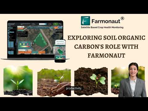
Soil Health Analysis: The Foundation of Healthy Crops
Understanding your soil is crucial for optimizing crop growth. Our soil health analysis tools provide comprehensive insights into your soil’s composition, nutrient levels, and organic matter content. This information enables you to:
- Tailor fertilizer applications
- Improve soil structure
- Enhance water retention
- Promote beneficial microbial activity
By maintaining healthy soil, you create the perfect foundation for robust crop growth and sustainable farming practices.
Weather Data for Farming: Make Informed Decisions
Weather data for farming is essential for planning and risk management. Our platform integrates real-time weather information and forecasts, allowing you to:
- Plan planting and harvesting schedules
- Prepare for extreme weather events
- Optimize irrigation timing
- Adjust crop protection measures
By staying ahead of weather patterns, you can protect your crops and maximize your yields even in challenging conditions.
“GIS technology in agriculture can improve crop yield predictions by up to 90% accuracy compared to traditional methods.”
Precision Fertilizer Application: Give Your Crops What They Need
Precision fertilizer application is a game-changer for modern agriculture. By combining soil analysis, crop health data, and yield maps, we can help you create variable-rate fertilizer prescriptions that:
- Reduce fertilizer waste
- Improve nutrient uptake
- Minimize environmental impact
- Optimize crop yields
This targeted approach ensures that every part of your field receives the right amount of nutrients, leading to healthier crops and reduced input costs.
Digital Farming Solutions: Bringing It All Together
Our comprehensive digital farming solutions integrate all these technologies into a user-friendly platform. Through our mobile and web applications, you can:
- Access real-time crop health data
- Generate custom treatment plans
- Track field operations
- Analyze historical trends
By centralizing your farm management, you can make data-driven decisions that improve efficiency and profitability across your entire operation.
Agricultural Data Analytics: Turning Insights into Action
Agricultural data analytics is at the heart of precision farming. Our advanced algorithms process vast amounts of data to provide you with actionable insights, including:
- Yield predictions
- Resource optimization recommendations
- Risk assessments
- Market trend analysis
By leveraging big data and machine learning, we help you make smarter decisions that drive profitability and sustainability.
Crop Growth Monitoring: Watch Your Fields Thrive
Our crop growth monitoring tools provide a comprehensive view of your crops’ development throughout the growing season. By tracking key metrics such as plant height, leaf area index, and biomass accumulation, you can:
- Identify growth anomalies early
- Adjust management practices in real-time
- Optimize harvest timing
- Improve crop quality and yield
This continuous monitoring ensures that your crops receive the attention they need at every stage of growth.
Sustainable Agriculture Practices: Farming for the Future
At Farmonaut, we’re committed to promoting sustainable agriculture practices. Our technology supports environmentally friendly farming by:
- Reducing chemical inputs
- Improving water use efficiency
- Minimizing soil erosion
- Enhancing biodiversity
By adopting these practices, you can ensure the long-term health of your land while meeting the growing demand for sustainably produced food.
Field Mapping Technology: Know Your Land
Our advanced field mapping technology goes beyond simple boundary delineation. We provide detailed maps that include:
- Topographical information
- Soil type variations
- Drainage patterns
- Historical yield data
These comprehensive maps serve as the foundation for all your precision farming activities, enabling targeted management strategies across your entire farm.
Precision Agriculture Sensors: Data Collection at the Ground Level
Precision agriculture sensors deployed across your fields provide real-time data on crucial parameters such as:
- Soil moisture
- Temperature
- Humidity
- Light intensity
This ground-level data complements our satellite and drone imagery, giving you a complete picture of your farm’s conditions.
Vegetation Index Analysis: Beyond NDVI
While NDVI is a powerful tool, our vegetation index analysis includes a range of indices to provide a more comprehensive view of crop health:
- Enhanced Vegetation Index (EVI)
- Soil Adjusted Vegetation Index (SAVI)
- Normalized Difference Water Index (NDWI)
- Leaf Area Index (LAI)
By analyzing multiple indices, we can detect subtle changes in crop health and tailor our recommendations to your specific needs.
Farmonaut Satellite System Benefits Comparison
| Agricultural Aspect | Traditional Methods | Farmonaut Satellite System |
|---|---|---|
| Crop Monitoring Frequency | Weekly | Daily |
| Pest Detection Accuracy | 60-70% | 85-95% |
| Irrigation Efficiency | 70% | 90% |
| Fertilizer Application Precision | Uniform application | Variable-rate, targeted application |
| Yield Prediction Accuracy | 75-80% | 90-95% |
Embrace the Future of Farming with Farmonaut
As we’ve explored throughout this article, the integration of satellite crop monitoring, GIS technology, and precision agriculture tools can significantly boost your farm’s productivity while reducing costs and environmental impact. At Farmonaut, we’re committed to making these advanced technologies accessible and affordable for farmers of all sizes.
Ready to revolutionize your farming practices? Take the first step towards precision agriculture by exploring our solutions:
- Web Application: Access our full suite of tools from your computer or tablet.
- Android App: Monitor your farm on-the-go with our mobile application.
- iOS App: iPhone users can also benefit from our powerful mobile tools.
- API Access: Integrate our data into your existing systems for seamless operations.
- API Developer Docs: Detailed documentation for developers looking to leverage our technology.
Join the precision agriculture revolution and see the difference Farmonaut can make on your farm. Together, we can create a more sustainable and productive future for agriculture.
Frequently Asked Questions
Q: How often does Farmonaut update satellite imagery?
A: We provide daily updates for most regions, ensuring you always have the most current information about your fields.
Q: Can Farmonaut’s technology be used for all types of crops?
A: Yes, our solutions are adaptable to a wide range of crops, from grains and vegetables to orchards and vineyards.
Q: How accurate are the yield predictions?
A: Our yield predictions typically achieve 90-95% accuracy, thanks to our advanced algorithms and comprehensive data analysis.
Q: Is Farmonaut’s system suitable for small farms?
A: Absolutely! We offer scalable solutions that can benefit farms of all sizes, from small family operations to large commercial enterprises.
Q: How can I get started with Farmonaut?
A: Simply sign up for an account on our website or download our mobile app to begin exploring our precision agriculture tools.
Embrace the future of farming with Farmonaut. Let’s work together to maximize your yields, reduce costs, and promote sustainable agriculture practices. The revolution in farming is here – are you ready to be part of it?