Revolutionizing Conservation: How GIS and Remote Sensing Empower Biodiversity Protection Strategies

“GIS technology has increased conservation efficiency by up to 40% in some protected areas through improved data analysis and mapping.”
In the ever-evolving world of conservation science, we’re witnessing a remarkable transformation. Geographic Information Systems (GIS) and remote sensing technologies are revolutionizing the way we approach biodiversity protection and environmental management. As we delve into this fascinating intersection of technology and nature, we’ll explore how these innovative tools are empowering conservationists, scientists, and policymakers to tackle some of the most pressing environmental challenges of our time.
The Power of GIS in Conservation
GIS for conservation has become an indispensable tool in the modern conservationist’s toolkit. This powerful technology allows us to collect, analyze, and visualize geospatial data in ways that were previously unimaginable. By integrating various layers of information – from topography and vegetation cover to species distributions and human activities – GIS provides a comprehensive view of ecosystems and their dynamics.
- Habitat Mapping: GIS enables precise mapping of habitats, helping identify critical areas for protection.
- Species Tracking: We can monitor wildlife movements and populations with unprecedented accuracy.
- Climate Change Impact Assessment: GIS models help predict and visualize the effects of climate change on ecosystems.
- Human-Wildlife Conflict Management: By analyzing spatial patterns, we can develop strategies to mitigate conflicts between humans and wildlife.
The applications of GIS in conservation are vast and growing. From creating interactive maps that engage the public to developing comprehensive management plans for protected areas, GIS is transforming the landscape of conservation efforts worldwide.
Remote Sensing: Eyes in the Sky for Biodiversity
Remote sensing technologies have opened up new frontiers in biodiversity protection strategies. Satellites, drones, and other airborne sensors provide us with a bird’s-eye view of the Earth’s surface, allowing us to monitor vast areas of land and sea with incredible detail and frequency.
Here are some key applications of remote sensing in conservation:
- Ecosystem Monitoring: We can track changes in vegetation cover, deforestation rates, and land use patterns over time.
- Wildlife Habitat Assessment: Remote sensing data helps identify suitable habitats for endangered species.
- Illegal Activity Detection: Satellite imagery can reveal unauthorized logging, mining, or poaching activities in protected areas.
- Disaster Response: During natural disasters, remote sensing provides crucial information for rapid assessment and response.
The power of remote sensing lies in its ability to provide consistent, repeatable, and objective data over large scales. This is particularly valuable in regions where ground-based surveys are challenging or dangerous to conduct.
Integrating GIS and Remote Sensing for Comprehensive Conservation
When we combine GIS and remote sensing technologies, we create a powerful synergy that enhances our ability to protect and manage biodiversity. This integration allows for more sophisticated analysis and decision-making processes:
- Predictive Modeling: By analyzing historical remote sensing data within a GIS framework, we can predict future trends in habitat change or species distribution.
- Precision Conservation: We can target conservation efforts more effectively by identifying high-priority areas based on multiple layers of spatial data.
- Adaptive Management: Regular updates from remote sensing data allow for real-time adjustments to conservation strategies within GIS-based management systems.
- Ecosystem Service Valuation: GIS and remote sensing data can help quantify and map ecosystem services, informing policy decisions and conservation planning.
This integrated approach is revolutionizing how we understand and manage complex ecological systems, enabling more effective and efficient conservation actions.
Farmonaut: Pioneering Geospatial Solutions for Agriculture and Conservation
In the realm of agricultural technology, Farmonaut stands out as a leader in leveraging geospatial data for sustainable farming practices. While primarily focused on agriculture, their innovative approaches have significant implications for conservation efforts, especially in areas where agricultural activities intersect with biodiversity hotspots.
Farmonaut’s platform integrates satellite imagery, AI, and machine learning to provide valuable insights for farm management. These technologies, when applied to conservation contexts, can offer powerful tools for monitoring ecosystem health and agricultural impacts on biodiversity.
Key features of Farmonaut’s technology that benefit conservation include:
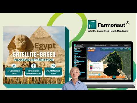
- Satellite-Based Crop Health Monitoring: This technology can be adapted to monitor vegetation health in natural ecosystems, providing early warning signs of degradation or stress.
- AI Advisory System: While designed for farm management, similar AI-driven systems could offer advice on managing protected areas or restoring degraded habitats.
- Blockchain-Based Traceability: This feature ensures transparency in agricultural supply chains, which can be crucial for verifying sustainable and biodiversity-friendly farming practices.
- Carbon Footprinting: By helping agribusinesses monitor their environmental impact, this tool contributes to broader efforts to mitigate climate change, a key factor in biodiversity conservation.
To explore these innovative solutions, you can access Farmonaut’s services through their various platforms:


For developers interested in integrating Farmonaut’s geospatial data into conservation projects, the API and API Developer Docs provide valuable resources.
Empowering Conservationists with Cutting-Edge Tools
The integration of GIS and remote sensing technologies is not just about data collection; it’s about empowering conservationists with the tools they need to make informed decisions and take effective action. Here’s how these technologies are changing the game:
- Mobile GIS Apps: Field researchers can now collect and upload data in real-time, enhancing the speed and accuracy of conservation efforts.
- Cloud-Based Platforms: Collaborative platforms allow teams to share and analyze data from anywhere in the world, fostering global partnerships in conservation.
- Machine Learning Algorithms: Advanced algorithms can process vast amounts of geospatial data, identifying patterns and trends that might be missed by human analysts.
- 3D Visualization: GIS tools can create immersive 3D models of landscapes, helping stakeholders better understand complex ecological relationships.
These tools are not just improving efficiency; they’re expanding the scope of what’s possible in conservation science. By leveraging these technologies, we’re able to tackle environmental challenges at scales that were previously unimaginable.
“Remote sensing satellites can detect changes in biodiversity hotspots with 95% accuracy, enabling rapid response to environmental threats.”
Precision Farming and Sustainable Land Management
While our focus is on conservation, it’s important to recognize the role of sustainable agriculture in biodiversity protection. Precision farming techniques, powered by GIS and remote sensing, are helping to reduce the environmental impact of agriculture while improving productivity.
Spatial analysis for agriculture allows farmers to:
- Optimize resource use, reducing water consumption and chemical inputs
- Identify and protect biodiversity-rich areas within agricultural landscapes
- Implement targeted conservation measures, such as wildlife corridors or buffer zones
- Monitor soil health and prevent degradation
By promoting more sustainable land management practices, we can create a harmonious balance between agricultural productivity and biodiversity conservation.
Climate Change Mitigation and Adaptation Strategies
Climate change poses one of the greatest threats to global biodiversity. GIS and remote sensing technologies are crucial in developing strategies to mitigate and adapt to these changes:
- Carbon Sequestration Mapping: Identify and monitor areas with high carbon storage potential.
- Vulnerability Assessments: Analyze which species and ecosystems are most at risk from climate change impacts.
- Adaptation Planning: Design corridors and protected areas that account for future climate scenarios.
- Disaster Risk Reduction: Use predictive modeling to prepare for and respond to climate-related disasters.
By integrating climate data with biodiversity information, we can develop more robust and resilient conservation strategies for the future.
Public Engagement and Citizen Science
GIS and remote sensing technologies are not just for scientists and policymakers. They’re also powerful tools for engaging the public in conservation efforts:
- Interactive Maps: Create engaging visualizations that help the public understand complex environmental issues.
- Citizen Science Apps: Develop mobile applications that allow citizens to contribute to biodiversity monitoring efforts.
- Virtual Reality Experiences: Use GIS data to create immersive experiences that connect people with nature.
- Educational Programs: Integrate GIS and remote sensing into environmental education curricula.
By democratizing access to environmental data and tools, we can foster a greater sense of stewardship and encourage public participation in conservation efforts.

The Future of Conservation Technology
As we look to the future, the potential for GIS and remote sensing in conservation science is boundless. Emerging technologies and trends include:
- Internet of Things (IoT) Integration: Networks of connected sensors providing real-time data on environmental conditions.
- Artificial Intelligence and Deep Learning: Advanced algorithms that can analyze complex ecological relationships and predict future scenarios.
- Hyperspectral Imaging: More detailed remote sensing data that can provide insights into ecosystem health at unprecedented levels.
- Blockchain for Conservation: Ensuring transparency and traceability in conservation projects and wildlife trade monitoring.
These advancements promise to further revolutionize our approach to biodiversity protection and environmental management.
Comparison of GIS and Remote Sensing Technologies in Biodiversity Conservation
| Technology | Application in Conservation | Key Benefits | Challenges |
|---|---|---|---|
| Satellite Imagery | Large-scale habitat mapping, deforestation monitoring | Global coverage, regular updates | Cloud cover interference, resolution limitations |
| LiDAR | 3D forest structure analysis, biomass estimation | High-precision elevation data, canopy structure insights | High cost, data processing complexity |
| Drones | Wildlife surveys, anti-poaching surveillance | High-resolution imagery, flexible deployment | Limited flight time, regulatory restrictions |
| Mobile GIS Apps | Field data collection, citizen science projects | Real-time data upload, user-friendly interface | Connectivity issues in remote areas |
Conclusion: A New Era in Biodiversity Protection
As we’ve explored throughout this blog, GIS and remote sensing technologies are ushering in a new era of biodiversity protection and conservation science. These powerful tools are enabling us to understand, monitor, and manage our natural world with unprecedented precision and effectiveness.
From the depths of the oceans to the heights of mountain ranges, from dense tropical forests to arid deserts, these technologies are helping us safeguard the incredible diversity of life on our planet. They’re empowering conservationists, informing policymakers, and engaging the public in the critical work of protecting our natural heritage.
As we face the mounting challenges of climate change, habitat loss, and species extinction, the integration of GIS and remote sensing into conservation strategies offers hope. It provides us with the means to take swift, informed action to protect and restore our planet’s biodiversity.
The future of conservation is here, and it’s powered by technology. By embracing these innovative tools and approaches, we can work towards a more sustainable and biodiverse world for generations to come.
FAQs
- What is GIS and how does it benefit conservation efforts?
GIS (Geographic Information System) is a technology that captures, analyzes, and visualizes spatial data. In conservation, it helps map habitats, track species, and plan protected areas, significantly improving decision-making and resource management. - How does remote sensing contribute to biodiversity protection?
Remote sensing uses satellite or aerial imagery to monitor large areas. It helps detect changes in land use, forest cover, and ecosystem health, enabling rapid response to threats and informed conservation planning. - Can these technologies help in climate change mitigation?
Yes, GIS and remote sensing are crucial for climate change mitigation. They help map carbon sinks, monitor deforestation, and model climate impacts, supporting strategies to reduce greenhouse gas emissions and adapt to changing conditions. - How are precision farming techniques related to conservation?
Precision farming uses GIS and remote sensing to optimize agricultural practices, reducing resource use and environmental impact. This helps balance food production with biodiversity conservation in agricultural landscapes. - What role does Farmonaut play in conservation technology?
While primarily focused on agriculture, Farmonaut’s satellite-based monitoring and AI technologies can be adapted for conservation purposes, such as tracking vegetation health in natural ecosystems and monitoring environmental impacts.
