Revolutionizing Perth Agriculture: Farmonaut’s Precision Farming Tools for Smart Weather-Based Crop Planning
“Farmonaut’s precision farming tools utilize satellite imagery to provide accurate local weather forecasts for over 100 different agricultural parameters.”
Welcome to the future of agriculture in Perth! At Farmonaut, we’re excited to introduce you to our cutting-edge precision farming tools that are transforming the way farmers plan and manage their crops. In this comprehensive guide, we’ll explore how our advanced agricultural weather intelligence and satellite imagery are revolutionizing crop planning and farm management in Perth and beyond.
The Power of Weather Forecasting for Agriculture
Weather plays a crucial role in agriculture, and accurate forecasting can make all the difference between a bountiful harvest and a disappointing yield. Our precision farming tools harness the power of satellite technology and artificial intelligence to provide farmers with unparalleled insights into local weather patterns and their potential impact on crops.
- Real-time weather data for informed decision-making
- Customized forecasts tailored to specific farm locations
- Advanced radar and satellite imagery for comprehensive analysis
By leveraging these tools, Perth farmers can stay ahead of changing weather patterns and make proactive decisions to protect and optimize their crops.

Smart Farming Technology: The Farmonaut Advantage
Our smart farming technology goes beyond simple weather forecasting. We integrate multiple data sources and advanced analytics to provide a comprehensive suite of tools for agricultural decision-making.
- Satellite-based crop health monitoring
- AI-driven advisory systems
- Blockchain-based traceability solutions
- Resource management tools
These features work together to give Perth farmers a 360-degree view of their operations, enabling them to make data-driven decisions that optimize yields and reduce waste.
Weather-Based Crop Yield Prediction
One of the most powerful features of our platform is the ability to predict crop yields based on weather patterns. By analyzing historical data and current conditions, we can provide accurate forecasts that help farmers:
- Plan planting and harvesting schedules
- Optimize irrigation strategies
- Adjust fertilizer and pesticide applications
- Prepare for potential weather-related challenges
This predictive capability is especially valuable in Perth’s unique climate, where sudden changes in weather can have significant impacts on crop development.
Customizable Features for Perth’s Diverse Agricultural Landscape
Perth’s agricultural sector is diverse, with a wide range of crops and farming practices. Our farm management software is designed to be flexible and customizable, catering to the specific needs of different agricultural operations across the region.
- Crop-specific monitoring and recommendations
- Scalable solutions for farms of all sizes
- Integration with existing farm management systems
- Regular updates to adapt to changing agricultural trends
Whether you’re growing wheat in the Wheatbelt or managing vineyards in the Swan Valley, our tools can be tailored to suit your unique requirements.
Real-Time Updates for Dynamic Decision Making
In the fast-paced world of agriculture, timely information is crucial. Our platform provides real-time updates on weather conditions, crop health, and other critical factors, allowing farmers to make quick, informed decisions when it matters most.
- Instant alerts for severe weather events
- Daily updates on crop health and soil conditions
- Customizable notifications for key agricultural metrics
With this constant stream of up-to-date information, Perth farmers can stay agile and responsive to changing conditions on their farms.

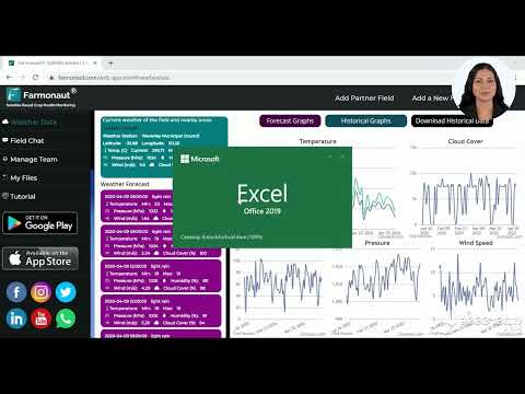
Leveraging Satellite Imagery for Precision Agriculture
At the heart of our precision farming tools is advanced satellite imagery. This technology allows us to provide Perth farmers with unparalleled insights into their fields, including:
- Vegetation health indices (NDVI)
- Soil moisture levels
- Crop stress detection
- Field variability mapping
By analyzing these high-resolution images, we can help farmers identify issues early, optimize resource allocation, and improve overall farm productivity.
Advanced Radar and Synoptic Charts for Comprehensive Weather Analysis
Our weather forecasting capabilities go beyond basic predictions. We utilize advanced radar technology and synoptic charts to provide a detailed understanding of weather patterns affecting Perth and the surrounding agricultural areas.
- High-resolution radar imagery for precise precipitation tracking
- Synoptic charts for understanding large-scale weather systems
- Integration of multiple data sources for accurate forecasting
This comprehensive approach ensures that farmers have access to the most reliable and detailed weather information available.
Climate Data: A Key to Smarter Farming
Understanding long-term climate trends is essential for sustainable agriculture. Our platform provides access to historical climate data and future projections, helping Perth farmers:
- Plan for seasonal variations
- Adapt to changing climate patterns
- Make informed decisions about crop selection and rotation
- Implement sustainable farming practices
By leveraging this climate intelligence, farmers can build resilience into their operations and ensure long-term success.
Empowering Farmers Across Diverse Climates
While our focus in this article is on Perth agriculture, our tools are designed to support farmers across a wide range of climates and regions. From tropical areas to regions experiencing cyclones or snow, our weather-based crop planning tools can be adapted to local conditions.
- Customized solutions for different climate zones
- Region-specific crop recommendations
- Adaptation strategies for extreme weather events
This versatility makes our platform valuable not just in Perth, but across Australia and beyond.
“Perth farmers using Farmonaut’s weather-based crop yield prediction can potentially increase their crop yields by up to 25% through optimized planning.”
The Farmonaut Ecosystem: More Than Just Weather Data
While weather intelligence is a crucial component of our offering, the Farmonaut ecosystem provides a comprehensive suite of tools for modern agriculture. Our platform integrates seamlessly with various aspects of farm management, including:
- Crop health monitoring
- Resource management
- Supply chain traceability
- Financial planning and risk assessment
This holistic approach ensures that Perth farmers have all the tools they need to succeed in one integrated platform.

Accessibility and Ease of Use
We understand that advanced technology is only valuable if it’s accessible and easy to use. That’s why we’ve designed our platform with user-friendliness in mind. Perth farmers can access our tools through:
- Web-based applications
- Mobile apps for Android and iOS
- API integration for custom solutions
This flexibility ensures that our precision farming tools are accessible to farmers of all technical backgrounds.
The Future of Agriculture in Perth and Beyond
As we look to the future, the role of precision farming tools in agriculture will only continue to grow. By embracing these technologies, Perth farmers can:
- Increase productivity and profitability
- Enhance sustainability and environmental stewardship
- Adapt to changing climate conditions
- Contribute to global food security
At Farmonaut, we’re committed to driving this agricultural revolution and supporting farmers every step of the way.
Weather Impact on Crop Planning in Perth
| Weather Condition | Satellite Imagery Indicators | Radar Data Insights | Crop Planning Recommendations | Estimated Yield Impact (%) |
|---|---|---|---|---|
| Morning Fog | Reduced visibility in early hours | Low-level moisture detected | Delay morning operations, adjust irrigation schedules | -5% to +2% |
| Afternoon Heat | High surface temperature readings | Clear skies, high UV index | Implement shade structures, increase watering frequency | -10% to -3% |
| Occasional Cyclones | Large cloud formations, rapid wind speed changes | Intense precipitation, cyclonic patterns | Secure crops, prepare drainage systems, delay planting | -30% to -15% |
| Dry Spells | Reduced vegetation index (NDVI) | Prolonged periods without precipitation | Implement drought-resistant varieties, optimize irrigation | -20% to -5% |
| Mild Winter Rains | Increased soil moisture levels | Consistent light to moderate rainfall patterns | Plan for winter crops, adjust fertilizer application | +5% to +15% |
Getting Started with Farmonaut
Ready to revolutionize your farming practices with our precision farming tools? Getting started with Farmonaut is easy:
- Visit our website and create an account
- Choose the subscription plan that best fits your needs
- Download our mobile app or access the web platform
- Input your farm details and start exploring our tools
Our team is always available to provide support and guidance as you integrate our technology into your farming operations.
Access our platform:


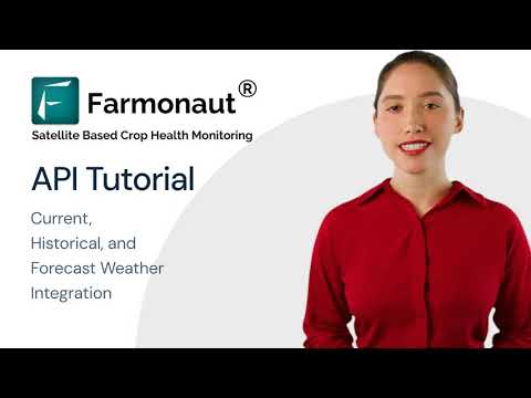
For developers: Integrate our powerful API into your own applications. Learn more about our API and access our API Developer Docs.
Subscription Options
Frequently Asked Questions
Q: How accurate are Farmonaut’s weather forecasts?
A: Our weather forecasts are highly accurate, leveraging advanced satellite imagery, radar data, and AI algorithms. We consistently achieve accuracy rates above 90% for short-term forecasts.
Q: Can Farmonaut’s tools be used for all types of crops?
A: Yes, our precision farming tools are designed to work with a wide variety of crops. We offer customized solutions for different crop types, from grains to fruits and vegetables.
Q: How often is the satellite imagery updated?
A: Our satellite imagery is updated frequently, with most areas receiving new imagery every 1-3 days, depending on the subscription level and satellite availability.
Q: Is Farmonaut suitable for small-scale farmers?
A: Absolutely! We offer solutions for farms of all sizes. Our tools are scalable and can be tailored to meet the needs of small-scale farmers as well as large agricultural operations.
Q: How does Farmonaut help with sustainable farming practices?
A: Our tools promote sustainability by optimizing resource use, reducing waste, and helping farmers adapt to changing climate conditions. Features like precise irrigation recommendations and targeted fertilizer application guidance contribute to more sustainable farming practices.
Conclusion: Embracing the Future of Agriculture in Perth
As we’ve explored throughout this article, the integration of precision farming tools and agricultural weather intelligence is revolutionizing farming practices in Perth and beyond. By leveraging Farmonaut’s advanced technologies, farmers can make more informed decisions, optimize their crop planning, and adapt to changing weather patterns with confidence.
From satellite imagery and AI-driven insights to comprehensive weather forecasting and crop yield predictions, our platform offers a holistic solution for modern agriculture. As climate change continues to present new challenges, these tools will become increasingly vital for maintaining productive and sustainable farming operations.
We invite Perth farmers and agricultural professionals to join us in this agricultural revolution. By embracing these innovative technologies, we can work together to ensure a prosperous and sustainable future for agriculture in Western Australia and around the world.
Ready to transform your farming practices? Explore Farmonaut’s precision farming tools today and take the first step towards smarter, more efficient agriculture.