NASA Radar Reveals Accelerating Landslides in Rancho Palos Verdes: Urgent Action Needed for California’s Shifting Terrain
“NASA radar data reveals ground movement rates up to 20 inches per year in Rancho Palos Verdes, California.”
In the picturesque coastal city of Rancho Palos Verdes, California, a silent but formidable threat looms beneath the surface. Recent NASA radar data has unveiled alarming rates of ground movement on the Palos Verdes Peninsula, south of Los Angeles, raising critical concerns about the region’s stability and the safety of its residents. As we delve into this pressing issue, we’ll explore the causes, consequences, and potential solutions to the accelerating landslides that are reshaping this California landscape.
Understanding the Landslide Crisis in Rancho Palos Verdes
The Palos Verdes Peninsula, known for its stunning ocean views and affluent communities, has a long history of geological instability. However, recent events have dramatically escalated the situation. In the summer of 2023, the remnants of Hurricane Hilary brought unprecedented rainfall to the region, triggering widespread land subsidence and putting the area under a state of emergency.
Fast forward to 2024, and the situation has only intensified. NASA’s advanced radar technology has revealed that parts of the terrain are now shifting at a rate of approximately four inches per week. This rapid movement poses a severe threat to the structural integrity of homes and infrastructure in the affected areas.

The Role of NASA’s Advanced Technology
At the forefront of this discovery is NASA’s Jet Propulsion Laboratory (JPL), which has employed cutting-edge technology to map and monitor the landslide-affected areas. The Uninhabited Aerial Vehicle Synthetic Aperture Radar, mounted on a Gulfstream III jet, has provided unprecedented insights into the extent and direction of soil movement.
This sophisticated mapping technique has allowed specialists to create detailed visualizations of the affected regions, offering a clear picture of the heightened risk to human life and infrastructure. Alexander Handwerger, a landslide scientist at JPL, has emphasized the significant expansion of the affected area and the alarming speed of the movement.
The Science Behind Landslides
To fully grasp the gravity of the situation in Rancho Palos Verdes, it’s essential to understand the science behind landslides. The U.S. Geological Survey defines landslides as a form of “mass wasting” – a process where soil, rock, and debris move downslope under the influence of gravity. Several factors can trigger or exacerbate landslides:
- Heavy Rainfall: Excessive water can saturate the ground, increasing its weight and reducing friction between soil particles.
- Snowmelt: Rapid melting can lead to soil saturation and instability.
- Erosion: Natural or human-induced erosion can undermine slope stability.
- Volcanic Eruptions: While not a factor in Rancho Palos Verdes, volcanic activity can trigger landslides in other regions.
- Human Activity: Construction, deforestation, and changes in land use can disrupt natural slope stability.
The Western United States, including states like California, Oregon, Washington, and Idaho, is particularly vulnerable to landslides due to its diverse geology and climate patterns. These natural disasters result in billions of dollars in damage annually, posing a significant challenge to communities and infrastructure.
The Impact on Rancho Palos Verdes
The consequences of the accelerating landslides in Rancho Palos Verdes are far-reaching and deeply concerning. Some of the immediate impacts include:
- Structural damage to homes, with some houses literally split apart
- Displacement of residents, with many choosing to leave the region
- Significant threats to critical infrastructure, including roads and utilities
- Economic repercussions, including property devaluation and increased insurance costs
It’s crucial to note that damage from landslides, similar to earthquake damage, is typically not covered under standard homeowners’ insurance policies. This lack of coverage leaves many residents financially vulnerable in the face of potential property loss.

Emergency Response and Mitigation Efforts
“A $42 million buyout program was initiated to address critical landslide risks in the Palos Verdes Peninsula area.”
In response to this critical situation, a collaborative effort involving multiple agencies has been launched. The City of Rancho Palos Verdes, the Federal Emergency Management Agency (FEMA), and the California Governor’s Office of Emergency Services have joined forces to address the landslide crisis. Key initiatives include:
- A $42 million buyout program for property owners affected by the landslides
- Implementation of deep dewatering wells to mitigate ground movement
- Ongoing monitoring and assessment of landslide activity
- Public awareness campaigns and emergency preparedness initiatives
The City of Rancho Palos Verdes has reported a slight deceleration in landslide activity since October 2024, attributed to drier weather conditions and the effectiveness of the dewatering initiatives. However, officials remain cautious and continue to seek additional financial support from state and federal agencies to bolster their stabilization efforts.
The Role of Technology in Landslide Detection and Monitoring
Advanced technology plays a crucial role in understanding and mitigating landslide risks. Synthetic Aperture Radar (SAR) mapping, as employed by NASA in Rancho Palos Verdes, is revolutionizing how we detect and monitor ground movement. This technology offers several advantages:
- High-resolution imaging of large areas
- Ability to penetrate cloud cover and operate in various weather conditions
- Detection of millimeter-scale ground deformations
- Continuous monitoring capabilities for long-term assessment
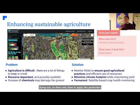
While NASA’s technology is at the forefront of landslide detection, other innovative solutions are also emerging in the field of environmental monitoring and disaster management. For instance, companies like Farmonaut are leveraging satellite technology and artificial intelligence to provide valuable insights into land use and environmental changes.

Farmonaut’s platform, while primarily focused on agricultural applications, demonstrates the potential of satellite-based monitoring systems in understanding and managing land dynamics. Their use of multispectral satellite images and AI-driven analysis could potentially be adapted to contribute to landslide risk assessment and monitoring in vulnerable areas.
Geological Hazards in the Western United States
The landslide crisis in Rancho Palos Verdes is not an isolated incident but part of a broader pattern of geological hazards that affect the Western United States. This region is particularly susceptible to various forms of mass wasting processes due to its diverse geological composition and dynamic climate. Some key factors contributing to this vulnerability include:
- Tectonic Activity: The Western U.S. is home to several active fault lines, including the infamous San Andreas Fault. Seismic activity can weaken soil structures and trigger landslides.
- Varied Topography: Steep slopes and mountainous terrain increase the potential for gravity-driven mass movements.
- Climate Variability: The region experiences periods of drought followed by intense rainfall, which can destabilize slopes.
- Wildfire Impact: Frequent wildfires can alter soil composition and vegetation cover, increasing erosion and landslide risk.
Understanding these regional factors is crucial for developing comprehensive strategies to mitigate landslide risks not only in Rancho Palos Verdes but across the entire Western United States.
The Challenges of Landslide Damage Insurance Coverage
One of the most significant challenges faced by residents in landslide-prone areas is the lack of adequate insurance coverage. Standard homeowners’ insurance policies typically exclude damage caused by earth movement, including landslides. This gap in coverage leaves many property owners financially vulnerable in the event of a disaster.
The reasons for this exclusion are complex:
- High-risk nature of landslide-prone areas
- Difficulty in predicting and quantifying landslide risk
- Potential for catastrophic losses in affected regions
Some insurance companies offer separate, specialized policies for earth movement coverage, but these can be prohibitively expensive and may have significant limitations. The situation underscores the need for innovative insurance solutions and potentially government-backed programs to provide financial protection for residents in high-risk areas.

Collaborative Efforts in Risk Mitigation
Addressing the complex challenges posed by landslides requires a multifaceted approach involving various stakeholders. In Rancho Palos Verdes and other at-risk areas, we’re seeing increased collaboration between:
- Local Governments: Implementing zoning regulations and building codes
- State Agencies: Providing resources and coordinating large-scale mitigation efforts
- Federal Organizations: Offering financial assistance and technical expertise
- Scientific Institutions: Conducting research and developing new monitoring technologies
- Private Sector: Innovating in areas of risk assessment and mitigation technologies
These collaborative efforts are essential for developing comprehensive, long-term solutions to landslide risks. They also highlight the importance of integrating scientific knowledge with policy-making and community engagement.
Explore Farmonaut’s API for advanced satellite data analysis
The Role of Community Preparedness
While large-scale mitigation efforts are crucial, community preparedness plays an equally important role in reducing the impact of landslides. Educating residents about landslide risks and preparedness measures can significantly enhance community resilience. Key aspects of community preparedness include:
- Understanding local landslide risks and warning signs
- Developing household emergency plans
- Participating in community-wide disaster drills
- Staying informed about local emergency procedures and evacuation routes
Local authorities in Rancho Palos Verdes and similar at-risk areas are increasingly focusing on public education and engagement as part of their comprehensive landslide management strategies.

Innovative Solutions for Landslide Monitoring
As technology continues to advance, new and innovative solutions for landslide monitoring and prediction are emerging. These technologies complement traditional methods and offer enhanced capabilities for early warning and risk assessment:
- LiDAR (Light Detection and Ranging): Provides high-resolution 3D mapping of terrain
- IoT Sensors: Offer real-time data on soil moisture, movement, and other critical parameters
- Machine Learning Algorithms: Analyze complex datasets to predict landslide likelihood
- Drone Technology: Enables frequent, detailed aerial surveys of at-risk areas
While these technologies are not yet widely implemented in Rancho Palos Verdes, they represent the future of landslide risk management and could significantly enhance the city’s ability to monitor and respond to ground movement.
Check out Farmonaut’s API Developer Docs for integration insights
The Economic Impact of Landslides
The economic consequences of landslides extend far beyond immediate property damage. In Rancho Palos Verdes and similar affected areas, the long-term economic impacts include:
- Decreased property values in at-risk zones
- Increased costs for infrastructure maintenance and repair
- Potential loss of tourism revenue
- Strain on local government budgets due to ongoing mitigation efforts
These economic challenges underscore the importance of proactive landslide management and the need for sustainable, long-term solutions that balance safety concerns with economic vitality.

Future Outlook and Long-term Strategies
As Rancho Palos Verdes grapples with its current landslide crisis, the focus is shifting towards long-term strategies for living with geological instability. These strategies may include:
- Reassessing urban planning and development in high-risk areas
- Investing in green infrastructure to manage water runoff and soil stability
- Developing more robust early warning systems
- Exploring innovative construction techniques for landslide-resistant structures
The situation in Rancho Palos Verdes serves as a critical case study for other communities facing similar geological hazards. The lessons learned here will likely inform landslide management practices across the Western United States and beyond.

The Importance of Continuous Monitoring and Adaptation
The dynamic nature of landslide risks necessitates a strategy of continuous monitoring and adaptive management. This approach involves:
- Regular reassessment of risk zones based on the latest data
- Updating emergency response plans to reflect changing conditions
- Integrating new technologies as they become available
- Fostering ongoing collaboration between scientists, policymakers, and community leaders
By maintaining a flexible and responsive approach, communities like Rancho Palos Verdes can better navigate the challenges posed by evolving landslide risks.

Landslide Risk Factors and Mitigation Measures in Rancho Palos Verdes
| Risk Factor | Severity (Low/Medium/High) | Mitigation Measure |
|---|---|---|
| Heavy Rainfall | High | Dewatering Initiatives, Improved Drainage Systems |
| Geological Composition | High | Synthetic Aperture Radar Monitoring, Soil Stabilization Techniques |
| Erosion | Medium | Vegetation Management, Retaining Walls |
| Urban Development | Medium | Zoning Regulations, Infrastructure Reinforcement |
| Seismic Activity | Low | Building Code Updates, Seismic Monitoring |
Conclusion: A Call for Vigilance and Innovation
The accelerating landslides in Rancho Palos Verdes serve as a stark reminder of the dynamic and often unpredictable nature of our environment. As we face the challenges posed by shifting terrain and changing climate patterns, the need for innovative solutions and collaborative efforts has never been more apparent.
From advanced radar technology to community-based preparedness initiatives, the response to this crisis demonstrates the power of combining scientific knowledge with practical action. As we move forward, it’s clear that addressing landslide risks will require ongoing commitment, adaptability, and a willingness to embrace new technologies and approaches.
The situation in Rancho Palos Verdes is not just a local concern but a harbinger of challenges that many communities may face in the coming years. By learning from this experience and investing in proactive measures, we can work towards creating more resilient communities capable of withstanding the geological challenges of the future.
As we conclude, it’s important to remember that while technology and infrastructure play crucial roles in mitigating landslide risks, the human element – community awareness, preparedness, and cooperation – remains at the heart of effective disaster management. Together, through vigilance, innovation, and collective action, we can build a safer and more secure future in the face of nature’s ever-changing landscape.
FAQs
- What causes landslides in Rancho Palos Verdes?
Landslides in Rancho Palos Verdes are primarily caused by a combination of factors including heavy rainfall, geological composition, erosion, and urban development. - How accurate is NASA’s radar technology in detecting landslides?
NASA’s Synthetic Aperture Radar technology is highly accurate, capable of detecting ground movements as small as a few millimeters. - Are landslides covered by standard homeowners insurance?
Generally, standard homeowners insurance policies do not cover damage caused by landslides. Specialized “earth movement” coverage may be required. - What can residents do to prepare for potential landslides?
Residents can stay informed about local risks, develop emergency plans, participate in community preparedness activities, and consider geological factors when making property decisions. - How is the city of Rancho Palos Verdes addressing the landslide crisis?
The city is implementing various measures including a buyout program, dewatering initiatives, ongoing monitoring, and collaboration with state and federal agencies for additional support and resources.
Earn With Farmonaut: Join Farmonaut’s Affiliate Program
Earn 20% recurring commission with Farmonaut’s affiliate program by sharing your promo code and helping farmers save 10%. Onboard 10 Elite farmers monthly to earn a minimum of $148,000 annually—start now and grow your income!

** “Could earning money from home be the key to preventing future landslides? If so, how might the revenue generated from remote work opportunities like ‘Earn with Us!’ be funneled into environmental conservation efforts, specifically targeting areas at high risk of landslides like Rancho Palos Verdes? Would this be a sustainable and effective approach to mitigating geological hazards?