Cherry Trees in Zilina: 7 Must-See Bloom Locations on City Map
“Zilina’s digital city map highlights 7 prime cherry blossom spots, accessible via a public GIS application.”
- Introduction: A New Digital Spring in Zilina
- What is the Zilina GIS Application?
- Why Use the Cherry Trees in Zilina City Map?
- 7 Must-See Bloom Locations: Cherry Trees in Zilina
- Cherry Blossom Location Overview Table
- Access Real-Time City Information: Playgrounds, Sports Facilities, and More
- How to Access and Use Zilina’s GIS Blossom Application
- The Role of Technology: Satellite Data and Farmonaut’s Innovations
- Farmonaut App & API Links
- Farmonaut Precision Agriculture Subscriptions
- FAQ: Cherry Trees, Zilina GIS & Farmonaut
- Conclusion & Key Takeaways
Introduction: A New Digital Spring in Zilina
Spring in Zilina has always evoked images of blossoming cherry trees, couples sharing May Day kisses beneath pink canopies, and families enjoying parks adorned by delicate petals. This year, however, the city is raising the bar on tradition by blending nature and technology through the public GIS application Zilina—an innovative platform for tracking cherry tree bloom locations on a dynamic city map.
Thanks to the Zilina city authority’s investment in digital mapping and real-time geographic information systems, residents and visitors can now explore, plan, and visit the seven most picturesque cherry blossom sites in Zilina in just a few clicks. From playgrounds to park zones, and even tracking winter maintenance vehicles, it’s a revolution in public information access, blending urban living with the beauty of nature.

What is the Zilina GIS Application?
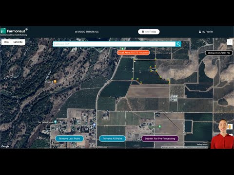
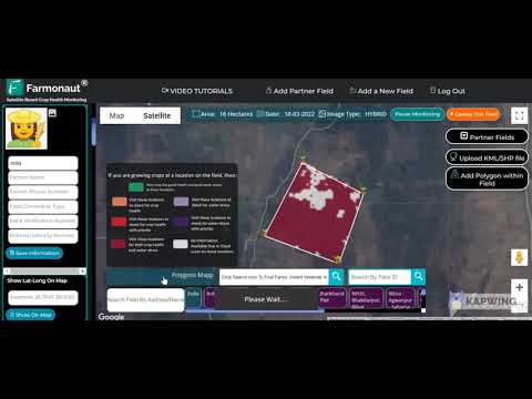
The Geographic Information System (GIS) application Zilina is a sophisticated public information system built for the modern era. Accessible via both computers and mobile devices, its digital maps of Zilina are more than just graphical city guides; they are living databases that provide:
- Real-time data on cherry tree blossom locations
- Land register and zoning plan maps
- Detailed overview of playgrounds and sports facilities
- Information on winter maintenance vehicles’ movement
- Regularly updated content for current, practical usage
This system offers:
- GPS localisation with your device’s GPS receiver
- Seamless interaction on both computer and mobile platforms
- Easy discovery of city life features—parks, transport, zoning, and more
By tapping on the “May Day Cherry Trees” icon, users instantly reveal mapped locations of cherry trees in Zilina that are currently in bloom, localized to your precise position.
Why Use the Cherry Trees in Zilina City Map?
The annual cherry tree blossom marks a special moment in Zilina’s calendar, but with climate shifts, blooms are occurring earlier each year. The city’s public GIS application Zilina adapts to these changes, allowing:
- Couples to plan perfect May Day kisses under the freshest canopies
- Nature lovers to organize photography trips around full bloom weeks
- Families to combine blossom sightseeing with playground and public park visits
- Planners to check zoning or transport info before heading out
- Eco-conscious citizens to navigate city terrain, track winter maintenance vehicles, and understand urban green zones
Whether you’re a resident or tourist, the city map’s cherry tree layer offers a one-of-a-kind way to experience Zilina’s renowned cherry blossoms efficiently and in synchrony with local happenings.
How the System Keeps Information Current and Practical
The GIS content is diligently updated by city authorities, ensuring that:
- Blooming dates of cherry trees reflect the actual season
- Playgrounds, facilities, and winter road vehicle movements match the current city plan and real-time city operations
- Zoning plans and the land register provide practical data for construction, planning, or routine excursions
“Real-time GIS in Zilina tracks over 20 city features, including cherry trees, playgrounds, and vehicle movement.”
7 Must-See Bloom Locations: Cherry Trees in Zilina
Let’s embark on a digital walking tour of the city’s most beloved cherry trees. The GIS application Zilina and digital maps guide you to each location, enriched by GPS localisation Zilina and information about each neighborhood’s surroundings.
-
1. Hurbanova Alej (Hurban Avenue Promenade):
-
GPS: 49.2226, 18.7391 (approx.)
A picturesque lane with a canopy of cherry blossoms lined up along its walkways. - Accessibility: Smooth, strollers-friendly, benches, nearby tram stop.
- Surroundings: Historic buildings, cafés, zoning for mixed use, artistic installations.
-
GPS: 49.2226, 18.7391 (approx.)
-
2. Bôrický Park:
-
GPS: 49.2208, 18.7271 (approx.)
An urban park with abundant cherry trees, sporting facilities, and children’s playgrounds. - Accessibility: Bicycle-friendly, play equipment, pathways, close to public transport.
- Surroundings: Large green area, family zones, sports facilities map overlay, zoning: recreational.
-
GPS: 49.2208, 18.7271 (approx.)
-
3. Vodné dielo Žilina (Zilina Water Reservoir Park):
-
GPS: 49.2200, 18.6967 (approx.)
A riverside recreational hotspot for walks and cycling, with blooms around viewing platforms. - Accessibility: Paved trails, bike routes, parking, close to water activities.
- Surroundings: Water views, jogging circuits, sports turf. Zoning: leisure/recreation.
-
GPS: 49.2200, 18.6967 (approx.)
-
4. Park Ľudovíta Štúra:
-
GPS: 49.2250, 18.7402 (approx.)
Centrally located, with a famous ring of cherry trees and frequent cultural activities. - Accessibility: Flat walkways, adjacent tram stop, playgrounds for children.
- Surroundings: Civic monuments, open market nearby, zoning: public/green space.
-
GPS: 49.2250, 18.7402 (approx.)
-
5. M. R. Štefánika Street Squares:
-
GPS: 49.2224, 18.7364 (approx.)
Streetside cherry trees, forming springtime canopies along the city’s pulse. - Accessibility: Pedestrian crossings, city bikes, bus stop access, zone: urban core.
- Surroundings: Shops, bakeries, quick food, historic zoning, close to central bus station.
-
GPS: 49.2224, 18.7364 (approx.)
-
6. Bulvár (Boulevard) Greenway:
-
GPS: 49.2195, 18.7312 (approx.)
A lively thoroughfare featuring rows of cherry blossoms, close to schools and sports areas. - Accessibility: Multiple playgrounds and sports facilities; paths wide for prams and bikes.
- Surroundings: Schools, fitness zones, zoning: education/urban residential.
-
GPS: 49.2195, 18.7312 (approx.)
-
7. Námestie Andreja Hlinku (Andrej Hlinka Square):
-
GPS: 49.2246, 18.7408 (approx.)
Zilina’s central square, hosting seasonal markets beneath beautiful cherry trees. - Accessibility: Wheelchair accessible, public transit, plenty of seating, direct to city events.
- Surroundings: City hall, art deco architecture, events square, zoning: public space/commercial.
-
GPS: 49.2246, 18.7408 (approx.)

Cherry Blossom Location Overview Table
To further assist you in exploring the cherry tree blossom locations of Zilina, we have compiled an easy-reference, SEO-friendly table containing key information for each site. Click or scan to access maps in the GIS application Zilina, check bloom status, or review local amenities.
| Location Name | GPS Coordinates (Est.) | Bloom Peak (Month/Week) | Accessibility Features | Map Link | GIS Real-Time Data | Notable Surroundings |
|---|---|---|---|---|---|---|
| Hurbanova Alej | 49.2226, 18.7391 | April, Week 2-3 | Benches, Stroller Access, Tram Stop | View Map | Yes | Historic buildings, Urban mixed-use |
| Bôrický Park | 49.2208, 18.7271 | April, Week 2 | Cycling, Playground, Bus Access | View Map | Yes | Sports fields, Family zones |
| Vodné dielo Žilina | 49.2200, 18.6967 | April, Week 3-4 | Paved, Bike Trails, Parking | View Map | Yes | Reservoir, Jogging tracks |
| Park Ľudovíta Štúra | 49.2250, 18.7402 | April, Week 2-3 | Flat, Playgrounds, Tram | View Map | Yes | Monuments, Markets |
| M. R. Štefánika Street Squares | 49.2224, 18.7364 | April, Week 1-2 | Pedestrian, Bikes, Bus | View Map | Yes | Urban core, Fast food |
| Bulvár Greenway | 49.2195, 18.7312 | April, Week 2 | Wide paths, Playgrounds, Fitness | View Map | Yes | Schools, Sports area |
| Námestie Andreja Hlinku | 49.2246, 18.7408 | April, Week 2-3 | Wheelchair, Events, Transit | View Map | Yes | City hall, Market square |
Estimated bloom peaks are based on recent years; check real-time GIS data for updates or bloom shifts.


Access Real-Time City Information: Playgrounds, Sports Facilities, and More
The public GIS application Zilina is not limited to cherry trees. It provides a comprehensive view of Zilina’s urban life:
- City zoning plan map: Visualize development and green zones, commercial areas, and historic overlays.
- Playgrounds and sports facilities map: Instantly find the nearest play lot or football field for kids and families.
- Winter maintenance vehicles map: Track the current movement of snow plows, gritters, and maintenance vehicles during colder months—keeping roads safe and accessible.
All this content is updated to reflect current statuses, helping us plan weekends, commutes, or family fun with confidence.
The Power of Localisation & Accessibility on the City Map
Using the GPS receiver in our device, the application allows precise localisation on the map. No more guessing—you can easily find yourself surrounded by cherry trees in bloom or closest to city amenities, thanks to GPS localisation Zilina.
How to Access and Use Zilina’s GIS Blossom Application
- Open the GIS Website or Mobile Application: On any computer or mobile device, visit the Zilina city GIS portal.
- Locate the “May Day Cherry Trees” Layer: Use the menu or map overlay tool to activate cherry tree blossom locations.
- Enable GPS on Your Device: Use your device’s GPS receiver for precise localisation, or manually select your neighborhood.
- Explore, Plan, and Visit: Combine cherry tree, playground, and zoning layers to plan an outing, share with others, or create your own cherry blossom photo trail.
The application is accessible to all, blending user-friendly design with cutting-edge mapping tools and applications.
The Role of Technology: Satellite Data and Farmonaut’s Innovations
While Zilina showcases leading municipal digital mapping, the broader field of mapping and resource tracking is being transformed by agricultural technology leaders like Farmonaut. Our mission is to make precision agriculture affordable and accessible to farmers worldwide, using advanced techniques like satellite imagery, artificial intelligence, blockchain, and resource management tools.
How Farmonaut’s Core Technologies Are Relevant
-
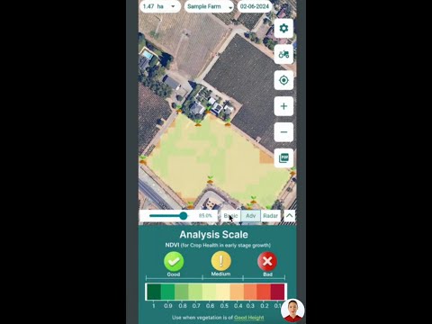
Satellite-Based Crop Health Monitoring:
Using multispectral satellite images, Farmonaut provides real-time insights into vegetation health (NDVI), soil moisture, and more. These insights empower both urban and rural users to optimize irrigation, fertilizer, and pest management, while supporting sustainability. -
AI and Advisory Systems:
Farmonaut’s Jeevn AI delivers personalized crop guidance with weather and management strategies—translating raw satellite data into actionable advice for increased yields. -
Blockchain-Based Product Traceability:
Our traceability solutions provide secure, transparent documentation of food and fiber from farm to consumer, crucial for today’s supply chain-conscious world. -
Fleet and Resource Management:
Track and manage vehicles and field machinery with Farmonaut’s fleet management tools—optimizing logistics, reducing costs. -
Carbon Footprinting:
Our carbon footprinting tools help map and reduce environmental impact, promoting transparent, sustainable agriculture and greener city spaces.
Farmonaut operates via a modular, subscription-based model, accessible through web and mobile apps or via API access. For technical integration and weather or satellite data into your own timeline or mapping project, review our developer documentation.
Supporting Large-Scale and Forest Management
Our large scale farm management solution provides comprehensive tools for plantation and forest tracking—supporting real-time mapping and precise field boundary analytics, much like advanced urban GIS but tailored for global agriculture.
Looking to join the digital revolution in crop, land, and resource management? Explore our smart advisory and monitoring app, or tap into our expertise for your projects—from city trees to vast agricultural estates.
Farmonaut App & API Links for Agile Mapping and Data Integration
-
Farmonaut API:
Analyze satellite and weather data for custom GIS, mapping, or IoT integrations.
https://sat.farmonaut.com/api -
Developer Docs:
Full reference and integration help.
https://farmonaut.com/farmonaut-satellite-weather-api-developer-docs/ -
Fleet & Resource Tracking:
For agribusinesses seeking to manage logistics and machinery usage: Fleet Management Benefits -
Product Traceability:
For transparent agri-supply and food tracing:
Farmonaut Traceability Platform -
Crop Loan and Insurance Verification:
Crop Loan & Insurance Satellite Verification -
Carbon Footprinting Services:
For sustainability, emission assessment, and reporting:
Farmonaut Carbon Footprinting
Farmonaut Precision Agriculture Subscriptions
Choose a subscription tailored to individual farmers, large operations, or institutions. Scale as you grow, access multispectral data, AI insights, and resource management—all without expensive hardware. Get started with the right plan below:
FAQ: Cherry Trees, Zilina’s GIS Map, and Farmonaut Technology
How do I find the nearest cherry tree in blossom in Zilina?
Open the Zilina GIS application, enable the “May Day Cherry Trees” layer, and let your device’s GPS receiver localize your position. Click any bloom icon to see live cherry blossom information and accessibility tips.
Is the GIS application for Zilina accessible on mobile devices?
Absolutely. The platform is designed for both computers and mobile devices. All features, including GPS-based localisation, work seamlessly on smartphones and tablets.
Besides cherry blossoms, what else can I track on Zilina’s public map?
The GIS offers layers for land register, zoning plan map, overview of playgrounds and sports facilities, winter maintenance vehicles, and much more—all content updated regularly.
What sort of real-time information does Farmonaut offer to the agriculture sector?
Farmonaut provides real-time crop health monitoring, a powerful AI-based advisory system (Jeevn AI), resource and fleet management tools, blockchain-based traceability, and carbon footprint analysis—enabling precise, data-driven decisions for all scales of farming.
How do I integrate Farmonaut satellite data or API into my own app or GIS project?
You can use the Farmonaut API for seamless satellite data integration, or consult our developer documentation for technical guidance.
What value does blockchain-based traceability bring to agribusinesses?
Blockchain technology, as implemented in Farmonaut’s traceability platform, ensures transparent, tamper-proof tracking of products and raw materials, increasing trust and reducing fraud in supply chains.
Conclusion & Key Takeaways
- The cherry trees in Zilina bloom brighter than ever with the city’s GIS-powered, digital map application. Residents and tourists can easily uncover seven must-see locations, just in time for the early blossom season.
- Technology shines beyond nature: Real-time overlays for zoning plans, playgrounds, sports facilities, and winter maintenance vehicle movements help everyone plan city life.
- Accessibility is universal: Available on both computers and mobile devices, the GIS public application Zilina brings current, practical public information to all, enhanced by GPS-based localisation.
- Farmonaut drives agricultural innovation worldwide with satellite data, AI, blockchain, resource tracking, carbon footprinting, and affordable, scalable subscriptions—democratizing precision farming and mapping for every scale of agriculture or city green zone.
Embrace the digital spring—explore, plan, and bloom with Zilina!