Revolutionizing Australian Agriculture: How Satellite Crop Monitoring and Weather Data Boost Farm Productivity

“Farmonaut’s satellite crop monitoring integrates data from over 10 different satellites for precise agricultural insights.”
In the vast expanse of Australia’s agricultural landscape, from the sun-drenched fields of Perth to the lush pastures of Sydney, a quiet revolution is taking place. At the heart of this transformation lies the intersection of precision agriculture weather data and satellite crop monitoring, heralding a new era of farming that’s as smart as it is sustainable. We at Farmonaut are proud to be at the forefront of this agricultural renaissance, leveraging cutting-edge technology to empower farmers across the continent and beyond.
The Dawn of Digital Agriculture in Australia
Australia’s agricultural sector has long been a cornerstone of the nation’s economy, adapting and evolving through challenges posed by its diverse and often harsh climate. From the tropical north to the temperate south, farmers have always looked to the skies for guidance. Today, however, they’re not just watching the clouds – they’re harnessing the power of satellites and advanced weather forecasting to make informed decisions that can make or break a season.
Our farm management software is designed to bridge the gap between traditional farming wisdom and modern technological capabilities. By integrating agricultural weather forecasting with sophisticated remote sensing techniques, we’re providing Australian farmers with unprecedented insights into their land and crops.
Satellite Crop Monitoring: Eyes in the Sky for Aussie Farmers
Imagine having a bird’s eye view of every hectare of your farm, updated regularly and accessible at your fingertips. That’s the reality we’re bringing to farmers from Melbourne to Brisbane, and everywhere in between. Our satellite crop monitoring technology uses advanced imagery to assess crop health, detect early signs of stress, and identify areas that need attention.
- Real-time vegetation health indices (NDVI)
- Early detection of pest and disease outbreaks
- Soil moisture analysis for optimal irrigation planning
- Crop growth stage monitoring for precise management
This level of detail allows farmers to make targeted interventions, reducing waste and maximizing yields. It’s not just about growing more; it’s about growing smarter.
Weather Intelligence: The Cornerstone of Climate-Smart Farming
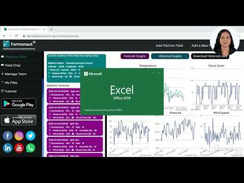
In a country where weather patterns can shift dramatically from one region to another, having access to accurate, localized weather data is crucial. Our agricultural weather forecasting system doesn’t just tell you if it’s going to rain – it provides a comprehensive suite of meteorological insights tailored specifically for farming applications.
- Hyperlocal rainfall predictions
- Max and min temperature forecasts for crop planning
- Wind speed and direction for spray timing decisions
- Frost and heat stress alerts to protect vulnerable crops
By integrating this data with our satellite imagery, we create a powerful tool for climate-smart farming that helps Australian farmers stay one step ahead of Mother Nature.
From Sydney to Perth: Tailored Solutions for Every Australian Farm
Australia’s agricultural diversity is one of its greatest strengths, but it also presents unique challenges. Our digital agriculture solutions are designed to be flexible and adaptable, catering to the specific needs of farms across the country:
- In Sydney and New South Wales, where water management is crucial, our soil moisture analytics help optimize irrigation.
- For wheat farmers in Western Australia, our yield prediction models assist in making informed marketing decisions.
- In Queensland, where tropical cyclones can threaten crops, our advanced weather alerts provide crucial early warnings.
- Victorian dairy farmers benefit from our pasture growth monitoring to maximize feed efficiency.

The Power of Prediction: Crop Yield Forecasting
One of the most powerful tools in our arsenal is our crop yield prediction technology. By analyzing historical data, current crop health, and future weather patterns, we can provide farmers with accurate yield forecasts weeks or even months in advance. This information is invaluable for:
- Financial planning and budgeting
- Resource allocation and labor management
- Marketing and sales strategies
- Supply chain optimization
Our predictive models are continually refined using machine learning algorithms, ensuring that they become more accurate with each passing season.
Smart Irrigation: Conserving Australia’s Most Precious Resource
Water scarcity is a perennial concern for many Australian farmers. Our smart irrigation systems leverage satellite and weather data to optimize water usage, ensuring that crops receive exactly what they need, when they need it. This not only conserves water but also promotes healthier plant growth and reduces the risk of water-related stress.
Features of our smart irrigation solution include:
- Real-time soil moisture monitoring
- Evapotranspiration-based irrigation scheduling
- Integration with local water restrictions and allocations
- Automated alerts for system malfunctions or unusual water usage patterns
“Australian farmers using Farmonaut’s technology have reported up to 30% increase in crop yields through optimized irrigation.”
Agricultural Data Analytics: Turning Information into Action
The true power of our platform lies in its ability to transform vast amounts of data into actionable insights. Our agricultural data analytics suite processes information from multiple sources, including:
- Satellite imagery
- Weather stations
- Soil sensors
- Historical yield data
- Market information
By analyzing these diverse data streams, we provide farmers with comprehensive reports and recommendations that support informed decision-making at every stage of the growing cycle.
Explore Our API | API Developer Docs
Beyond Australia: Global Reach, Local Impact
While our roots are in Australian agriculture, our technology is making waves across Oceania and beyond. From the rolling hills of New Zealand to the vast plains of Africa, farmers around the world are benefiting from our innovative approach to agricultural technology.
Our platform is designed to adapt to local conditions, whether you’re dealing with monsoons in South East Asia or drought in South America. By combining global satellite data with local weather patterns and agronomic knowledge, we create solutions that are truly global in scope but local in application.
The Future of Farming: Integrating Technology and Tradition
As we look to the future of agriculture in Australia and around the world, it’s clear that the integration of technology will play an increasingly crucial role. However, we at Farmonaut believe that this technological revolution should complement, not replace, the generations of farming wisdom that have shaped our agricultural landscapes.
Our goal is to provide tools that enhance farmers’ ability to make good decisions, not to make decisions for them. By combining the intuition and experience of farmers with the precision and foresight of our technology, we’re creating a new paradigm for sustainable, productive agriculture.
Comparative Analysis: Traditional vs. Satellite-Based Farming Methods
| Farming Aspect | Traditional Method | Satellite-Based Method | Estimated Productivity Increase (%) | Potential Cost Savings (AUD) |
|---|---|---|---|---|
| Irrigation Management | Manual observation, scheduled watering | Precision irrigation based on real-time soil moisture data | 25% | 5,000 – 10,000 per 100 hectares |
| Crop Health Monitoring | Visual inspection, periodic soil testing | NDVI analysis, early stress detection | 20% | 3,000 – 7,000 per 100 hectares |
| Weather Prediction Accuracy | Reliance on general forecasts | Hyperlocal, farm-specific weather data | 15% | 2,000 – 5,000 per farm |
| Fertilizer Application | Uniform application across fields | Variable rate application based on soil needs | 30% | 4,000 – 8,000 per 100 hectares |
| Pest Detection | Regular field scouting | Early detection through spectral analysis | 35% | 6,000 – 12,000 per 100 hectares |
| Yield Prediction | Historical averages, manual estimation | AI-driven predictive models | 10% | Varies based on crop and market conditions |

Embracing the Digital Agricultural Revolution
As we stand on the brink of a new era in farming, the opportunities for Australian agriculture are boundless. From the wheat fields of Western Australia to the sugar cane plantations of Queensland, farmers across the nation are embracing digital technologies to overcome challenges and seize new opportunities.
At Farmonaut, we’re committed to being partners in this journey, providing the tools and insights needed to navigate the complexities of modern agriculture. Whether you’re a small family farm or a large corporate operation, our platform is designed to scale with your needs and grow with your ambitions.


Join the Agricultural Innovation Movement
The future of farming is here, and it’s digital, data-driven, and more sustainable than ever before. By harnessing the power of satellite crop monitoring and advanced weather data, Australian farmers can not only boost their productivity but also play a crucial role in addressing global food security challenges.
We invite you to explore how Farmonaut can transform your farming operations, whether you’re in Brisbane, Adelaide, Darwin, or anywhere else across this great southern land. Together, we can cultivate a future where technology and tradition work hand in hand to create a more prosperous, sustainable agricultural sector for Australia and the world.

Frequently Asked Questions
- How accurate is satellite-based crop monitoring?
Our satellite crop monitoring is highly accurate, with resolution down to 3 meters for some applications. The integration of multiple satellite data sources ensures comprehensive and reliable information. - Can Farmonaut’s system work for small farms?
Absolutely! Our platform is scalable and can be tailored to farms of all sizes, from small family operations to large commercial enterprises. - How often is the satellite imagery updated?
Depending on the subscription level, imagery can be updated as frequently as every 1-3 days, ensuring you always have access to the most current data. - Is the weather data localized to my specific farm?
Yes, our weather forecasts are hyperlocal, providing data specific to your farm’s location for maximum accuracy and relevance. - How can I access Farmonaut’s services?
Our services are available via web application, mobile apps for both Android and iOS, and through our API for custom integrations.
Invest in Your Farm’s Future with Farmonaut
Ready to take your farming operations to the next level? Explore our subscription options below and find the perfect plan to suit your needs. From basic monitoring to comprehensive farm management solutions, we have a package for every Australian farmer looking to embrace the future of agriculture.
Join the ranks of forward-thinking Australian farmers who are revolutionizing their practices with Farmonaut’s cutting-edge technology. Whether you’re in the heart of the outback or along the coastal regions, our solutions are designed to help you thrive in the ever-changing world of agriculture. Let’s cultivate success together, one satellite image at a time.