Revolutionize Your Farm: Precision Agriculture with Satellite Crop Monitoring and Weather Forecasting
“Satellite-based precision agriculture can increase crop yields by up to 20% while reducing water usage by 30%”
In today’s rapidly evolving agricultural landscape, farmers face unprecedented challenges in maximizing crop yields, managing resources efficiently, and adapting to climate change. At Farmonaut, we’re at the forefront of a revolution in farming technology, harnessing the power of satellite imagery, artificial intelligence, and data analytics to transform the way we approach agriculture. In this comprehensive guide, we’ll explore how precision agriculture and satellite farming are revolutionizing crop monitoring and field management, empowering farmers to make data-driven decisions that boost productivity and sustainability.

The Power of Precision Agriculture
Precision agriculture is a farming management concept that leverages technology to observe, measure, and respond to variability in crops. By using satellite imagery, GPS technology, and advanced sensors, farmers can gain unprecedented insights into their fields, enabling them to make informed decisions about planting, irrigation, fertilization, and harvesting.
- Improved Resource Management: Precision agriculture allows for targeted application of water, fertilizers, and pesticides, reducing waste and environmental impact.
- Enhanced Crop Monitoring: Satellite imagery provides regular, high-resolution views of crop health, enabling early detection of issues.
- Data-Driven Decision Making: With access to real-time and historical data, farmers can make more informed choices about farm management.
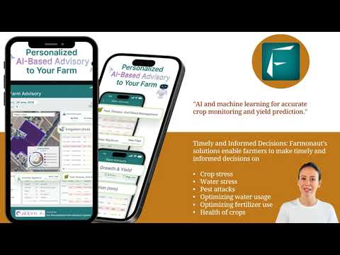
At Farmonaut, we’ve developed cutting-edge technologies that bring the benefits of precision agriculture to farms of all sizes. Our satellite-based crop health monitoring system uses multispectral imagery to provide insights into vegetation health, soil moisture levels, and other critical metrics.

Satellite Crop Monitoring: A Game-Changer for Farmers
Satellite crop monitoring is revolutionizing the way farmers observe and manage their fields. By providing regular, high-resolution imagery of crops, this technology enables farmers to detect issues early, track crop growth, and make data-driven decisions about field management.
- Real-Time Crop Health Assessment: Using vegetation indices like NDVI (Normalized Difference Vegetation Index), farmers can quickly identify areas of stress or poor growth.
- Historical Data Analysis: By comparing current crop conditions with historical data, farmers can identify trends and make informed predictions about yield potential.
- Efficient Field Scouting: Satellite imagery helps farmers prioritize which areas of their fields need immediate attention, saving time and resources.
Our Farmonaut platform leverages advanced satellite technology to provide farmers with daily updates on crop health, enabling them to respond quickly to emerging issues and optimize their farming practices.

Weather Forecasting for Agriculture: Precision Planning
Accurate weather forecasting is crucial for successful farming operations. With climate change increasing the frequency of extreme weather events, having access to reliable, localized weather data is more important than ever.
- Customized Forecasts: Our weather forecasting system provides detailed, farm-specific predictions, helping farmers plan activities like planting, spraying, and harvesting.
- Historical Weather Data: Access to long-term weather trends enables farmers to make informed decisions about crop selection and rotation strategies.
- Severe Weather Alerts: Timely warnings about potential weather hazards allow farmers to take preventive measures to protect their crops.
Farmonaut’s weather forecasting capabilities are integrated into our comprehensive farm management platform, providing farmers with a one-stop solution for all their agricultural planning needs.
“Precision farming techniques utilizing satellite data can help farmers save up to 15% on fertilizer costs annually.”
Soil Moisture Analysis: Optimizing Irrigation
Effective water management is crucial for maximizing crop yields and conserving resources. Our soil moisture analysis tools use satellite data and advanced algorithms to provide accurate estimates of soil moisture content across entire fields.
- Precision Irrigation: By identifying areas of water stress or excess moisture, farmers can adjust irrigation practices for optimal water use.
- Drought Monitoring: Early detection of drought conditions allows farmers to implement mitigation strategies before crop damage occurs.
- Water Conservation: By applying water only where and when it’s needed, farmers can significantly reduce water usage while maintaining or improving crop health.
Yield Prediction: Planning for Success
Accurate yield prediction is essential for effective farm management, financial planning, and optimizing harvest operations. Farmonaut’s yield prediction tools combine satellite imagery, historical data, and machine learning algorithms to provide reliable estimates of crop yields.
- Early Yield Estimates: Get accurate yield predictions weeks or even months before harvest, enabling better planning and resource allocation.
- Field Variability Mapping: Identify areas of high and low productivity within fields to inform targeted management strategies.
- Harvest Planning: Optimize harvest timing and logistics based on predicted yields and crop maturity.
By leveraging these advanced yield prediction capabilities, farmers can make more informed decisions about crop marketing, storage, and future planting strategies.

Agricultural Analytics: Turning Data into Action
The true power of precision agriculture lies in its ability to transform vast amounts of data into actionable insights. Farmonaut’s agricultural analytics platform combines data from multiple sources, including satellite imagery, weather stations, and on-field sensors, to provide comprehensive insights into farm performance.
- Performance Benchmarking: Compare your farm’s performance against regional averages and top performers to identify areas for improvement.
- Trend Analysis: Track long-term trends in crop health, yield, and resource usage to inform strategic decision-making.
- Custom Reporting: Generate detailed reports on various aspects of farm performance, tailored to your specific needs and goals.
Our advanced analytics tools empower farmers to make data-driven decisions that optimize productivity, reduce costs, and improve overall farm profitability.

Remote Sensing in Agriculture: Seeing Beyond the Visible
Remote sensing technologies, particularly those utilizing satellite imagery, have revolutionized our ability to monitor and manage agricultural lands. At Farmonaut, we leverage advanced remote sensing techniques to provide farmers with unprecedented insights into their fields.
- Multispectral Imaging: By analyzing light reflected from crops across different spectral bands, we can detect subtle changes in plant health often invisible to the naked eye.
- Thermal Imaging: Thermal sensors help identify variations in crop temperature, which can indicate stress, disease, or irrigation issues.
- Synthetic Aperture Radar (SAR): This technology allows for crop monitoring even through cloud cover, ensuring consistent data collection regardless of weather conditions.
Our remote sensing capabilities enable farmers to detect and respond to issues quickly, often before they become visible on the ground, leading to more proactive and effective farm management.
Explore Farmonaut’s API for advanced remote sensing data integration
Variable Rate Technology: Precision Application
Variable Rate Technology (VRT) is a key component of precision agriculture, allowing farmers to apply inputs like fertilizers, pesticides, and seeds at varying rates across a field based on specific needs of different areas.
- Optimized Resource Use: By applying inputs only where and when they’re needed, VRT significantly reduces waste and environmental impact.
- Improved Crop Quality: Precise application of nutrients and crop protection products can lead to more uniform crop quality across fields.
- Cost Savings: By reducing overall input use, VRT can lead to substantial cost savings for farmers.
Farmonaut’s platform integrates seamlessly with VRT equipment, providing the data and insights needed to create precise application maps for various inputs.
Crop Rotation Strategies: Enhancing Soil Health and Yield
Effective crop rotation is essential for maintaining soil health, managing pests and diseases, and optimizing yields over time. Our advanced analytics tools help farmers develop optimal crop rotation strategies based on historical data, soil conditions, and market trends.
- Soil Health Improvement: Analyze the impact of different crop rotations on soil organic matter and nutrient levels.
- Pest and Disease Management: Identify rotation sequences that help break pest and disease cycles naturally.
- Yield Optimization: Develop rotation plans that maximize overall farm productivity and profitability over multiple seasons.
By leveraging data-driven insights, farmers can implement crop rotation strategies that not only improve soil health but also contribute to long-term farm sustainability and profitability.

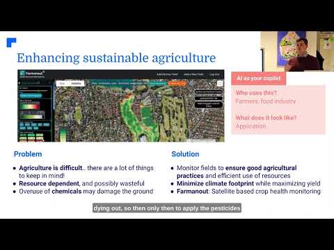
Sustainable Farming Practices: Balancing Productivity and Conservation
As global food demand continues to rise, the need for sustainable farming practices has never been more critical. Farmonaut is committed to helping farmers adopt practices that balance productivity with environmental conservation.
- Carbon Footprint Tracking: Our platform helps farmers monitor and reduce their carbon emissions, contributing to climate change mitigation efforts.
- Soil Conservation: Advanced soil analysis tools enable farmers to implement practices that reduce erosion and improve soil health.
- Biodiversity Promotion: We provide insights on how to integrate natural habitats and beneficial insects into farming systems, enhancing overall ecosystem health.
By adopting sustainable practices, farmers can not only reduce their environmental impact but also improve the long-term resilience and profitability of their operations.
Drone Use in Agriculture: Precision from Above
While satellite imagery provides broad coverage, drones offer an additional layer of precision for farm management. Farmonaut’s platform integrates drone data to complement our satellite-based insights, providing farmers with a comprehensive view of their fields.
- High-Resolution Imagery: Drones can capture detailed images of specific areas of interest, enabling precise problem diagnosis.
- Flexible Deployment: Farmers can quickly deploy drones to assess crop damage after severe weather events or to monitor specific areas of concern.
- Specialized Sensors: Drones equipped with multispectral or thermal cameras can provide additional data on crop health and stress levels.
By combining satellite and drone technologies, we offer farmers a powerful toolkit for comprehensive field monitoring and management.
NDVI Crop Health Monitoring: The Power of Vegetation Indices
The Normalized Difference Vegetation Index (NDVI) is a powerful tool for assessing crop health and vigor. By measuring the difference between near-infrared and red light reflected by vegetation, NDVI provides valuable insights into plant photosynthetic activity and overall health.
- Early Stress Detection: NDVI can reveal plant stress before it becomes visible to the naked eye, allowing for early intervention.
- Growth Stage Monitoring: Track crop development throughout the growing season to optimize management practices.
- Yield Estimation: NDVI values correlate strongly with potential yield, helping farmers make informed harvest planning decisions.
Farmonaut’s platform provides regular NDVI updates for monitored fields, enabling farmers to track crop health trends and respond quickly to any issues that arise.
Geospatial Technology in Farming: Mapping the Future of Agriculture
Geospatial technology is at the heart of precision agriculture, providing the framework for collecting, analyzing, and visualizing farm data. Our platform leverages advanced geospatial tools to help farmers make sense of complex spatial and temporal data.
- Field Boundary Mapping: Accurate field boundary delineation ensures precise area calculations and targeted management.
- Soil Type Mapping: Detailed soil maps help farmers tailor their management practices to specific soil conditions within fields.
- Yield Mapping: Create high-resolution yield maps to identify productivity patterns and inform future management decisions.
By harnessing the power of geospatial technology, we enable farmers to visualize and analyze their farm data in new and insightful ways, leading to more informed decision-making and improved farm management.
Access our API Developer Docs for advanced geospatial integration
Climate-Smart Agriculture: Adapting to a Changing World
As climate change continues to impact agricultural systems worldwide, adopting climate-smart practices is crucial for ensuring long-term farm sustainability. Farmonaut’s platform supports farmers in implementing climate-smart strategies through data-driven insights and advanced forecasting.
- Climate Risk Assessment: Analyze historical climate data and future projections to identify potential risks to crop production.
- Adaptive Crop Selection: Recommend crop varieties and management practices best suited to changing climate conditions.
- Water Management: Optimize irrigation practices to conserve water and improve resilience to drought conditions.
By embracing climate-smart agriculture, farmers can not only mitigate risks associated with climate change but also contribute to global efforts to reduce greenhouse gas emissions from agricultural activities.
Farmonaut: Your Partner in Precision Agriculture
At Farmonaut, we’re committed to making precision agriculture accessible and affordable for farmers worldwide. Our comprehensive platform integrates cutting-edge satellite technology, AI-driven analytics, and user-friendly tools to help farmers optimize their operations and boost productivity.
- Real-Time Monitoring: Get daily updates on crop health, weather conditions, and field performance.
- AI-Powered Insights: Our Jeevn AI advisory system provides personalized recommendations based on your farm’s unique conditions.
- Scalable Solutions: Whether you’re managing a small family farm or a large agricultural enterprise, our platform can be tailored to meet your needs.
Join the precision agriculture revolution with Farmonaut and take your farming operations to the next level.
Comparison: Traditional Farming vs. Farmonaut Satellite System
| Aspect | Traditional Farming | Farmonaut Satellite System |
|---|---|---|
| Crop Monitoring Frequency | Weekly/Monthly | Daily/Real-time |
| Weather Forecasting Accuracy | General regional forecasts | Field-specific, high-precision forecasts |
| Soil Moisture Analysis | Manual spot checks | Continuous, field-wide monitoring |
| Yield Prediction | Based on historical averages | AI-driven, real-time predictions |
| Resource Optimization | Uniform application | Variable rate, needs-based application |
| Environmental Impact | Higher resource use | Reduced input use, lower environmental footprint |
Farmonaut Subscriptions
Frequently Asked Questions
Q: How often is satellite imagery updated on the Farmonaut platform?
A: Our platform provides daily updates for monitored fields, ensuring you always have the most current information about your crops.
Q: Can Farmonaut’s technology be used for all types of crops?
A: Yes, our satellite monitoring and analytics tools are effective for a wide range of crop types, from grains and oilseeds to fruits and vegetables.
Q: How accurate are Farmonaut’s yield predictions?
A: Our yield predictions have shown high accuracy in field tests, typically within 5-10% of actual yields. However, accuracy can vary depending on factors such as crop type and environmental conditions.
Q: Is Farmonaut’s platform suitable for small-scale farmers?
A: Absolutely! We offer scalable solutions that cater to farms of all sizes, making precision agriculture accessible and affordable for small-scale farmers.
Q: How does Farmonaut integrate with existing farm management software?
A: Farmonaut offers API access, allowing for seamless integration with many popular farm management systems. Our team can assist with custom integrations as needed.
Conclusion: Embracing the Future of Farming
As we face the challenges of feeding a growing global population in an era of climate change, precision agriculture and satellite farming technologies offer a path forward. By leveraging the power of satellite imagery, AI-driven analytics, and data-driven insights, farmers can optimize their operations, reduce environmental impact, and increase profitability.
Farmonaut is at the forefront of this agricultural revolution, providing farmers with the tools and technologies they need to thrive in the 21st century. From real-time crop monitoring and weather forecasting to advanced yield prediction and resource optimization, our platform empowers farmers to make informed decisions that drive success.
As we look to the future, the integration of precision agriculture technologies will be crucial in addressing global food security challenges while promoting sustainable farming practices. By embracing these innovative solutions, we can create a more resilient, productive, and sustainable agricultural sector that benefits farmers, consumers, and the planet alike.
Join us in revolutionizing agriculture. Explore Farmonaut’s solutions today and take the first step towards a more productive, sustainable, and profitable farming future.