Revolutionizing Agriculture: How Satellite Crop Monitoring and NDVI Analysis Drive Precision Farming Success
“Satellite crop monitoring can analyze up to 5 spectral bands to assess vegetation health and stress levels.”
In the ever-evolving landscape of modern agriculture, we find ourselves at the forefront of a technological revolution that is reshaping the way we approach farming. At the heart of this transformation lies the powerful combination of satellite crop monitoring and precision agriculture technology, tools that are fundamentally changing how we understand and manage our agricultural resources.
As we delve into the world of remote sensing in agriculture, we’ll explore how these cutting-edge technologies are not just improving farm productivity, but also promoting sustainability and resource efficiency on a global scale. From the intricacies of NDVI vegetation index analysis to the deployment of agricultural drone services, we’ll uncover the myriad ways in which digital agriculture is revolutionizing farming practices.
The Power of Satellite Crop Monitoring
Satellite crop monitoring has emerged as a game-changer in the agricultural sector. By harnessing the power of space technology, farmers and agronomists can now gain unprecedented insights into crop health, soil conditions, and environmental factors that influence agricultural productivity.

Key benefits of satellite crop monitoring include:
- Real-time crop health assessment
- Early detection of pest infestations and diseases
- Optimization of irrigation and fertilizer application
- Improved yield forecasting
- Enhanced decision-making for farm management
By leveraging multispectral satellite imagery, we can analyze various band combinations to extract valuable information about crop conditions. The infrared and near-infrared bands, in particular, are crucial for assessing vegetation health and vigor.
Understanding NDVI: The Key to Precision Agriculture
The NDVI vegetation index (Normalized Difference Vegetation Index) is a cornerstone of precision agriculture technology. This powerful tool allows us to quantify vegetation health and density by measuring the difference between near-infrared light (which vegetation strongly reflects) and red light (which vegetation absorbs).
“NDVI analysis can detect crop health variations as small as 0.1% across vast agricultural landscapes.”
NDVI values range from -1 to +1, with higher values indicating healthier, denser vegetation. By analyzing NDVI data over time, we can:
- Track crop growth stages
- Identify areas of stress or poor health
- Optimize fertilizer and water application
- Predict potential yields
- Monitor the impact of management practices
Integrating Farm Management Software for Comprehensive Insights
To truly harness the power of satellite data, it’s essential to integrate it with robust farm management software. Platforms like Farmonaut offer comprehensive solutions that combine satellite imagery with advanced analytics to provide actionable insights for farmers and agronomists.
Key features of modern farm management software include:
- Soil health analysis: Assessing soil composition, organic carbon content, and nutrient levels
- Crop yield prediction: Utilizing historical data and current conditions to forecast harvest outcomes
- Agricultural data analytics: Processing vast amounts of data to identify trends and opportunities for optimization
- Smart farming solutions: Integrating IoT devices and sensors for real-time monitoring and automation

By leveraging these advanced tools, farmers can make data-driven decisions that optimize resource use, reduce waste, and ultimately improve their bottom line.
Precision Irrigation Systems: Maximizing Water Efficiency
Water scarcity is a growing concern in many agricultural regions. Precision irrigation systems, powered by satellite data and soil moisture sensors, are revolutionizing water management in agriculture. These systems allow for:
- Targeted application of water based on crop needs
- Reduction of water waste through over-irrigation
- Improved crop quality and yield through optimal water management
- Integration with weather forecasting for proactive irrigation planning
By combining satellite-derived NDWI (Normalized Difference Water Index) data with on-ground sensors, we can create highly accurate irrigation maps that guide precise water application across fields.
Crop Stress Detection: Early Warning for Better Management
Crop stress detection is another critical application of satellite technology in agriculture. By analyzing multispectral imagery and vegetation indices, we can identify early signs of:
- Nutrient deficiencies
- Pest infestations
- Disease outbreaks
- Water stress
Early detection allows farmers to take prompt action, potentially saving crops and reducing the need for extensive pesticide or fertilizer use. This not only improves crop yields but also promotes more sustainable farming practices.

Agricultural Satellite Imagery: A Window into Crop Health
Agricultural satellite imagery provides a wealth of information that was previously unattainable at such a large scale. By analyzing different band combinations and applying various image processing techniques, we can extract valuable insights about crop health and field conditions.
Key aspects of agricultural satellite imagery include:
- Color stretching: Enhancing image contrast to highlight subtle differences in vegetation
- Time-lapse animations: Visualizing crop growth and changes over time
- Composite images: Combining multiple spectral bands for comprehensive analysis
- Resolution: High-resolution imagery for detailed field-level insights
Platforms like Farmonaut utilize advanced image processing algorithms to deliver clear, actionable insights from satellite data, making it easier for farmers to interpret and apply this information in their daily operations.
Sustainable Farming Practices: The Role of Satellite Technology
Sustainable farming practices are becoming increasingly important as we face challenges like climate change and resource scarcity. Satellite technology plays a crucial role in promoting sustainability by:
- Optimizing resource use (water, fertilizers, pesticides)
- Monitoring soil health and organic carbon levels
- Tracking deforestation and land-use changes
- Supporting precision agriculture techniques that reduce environmental impact
By providing accurate, timely data on crop and environmental conditions, satellite monitoring enables farmers to make more informed decisions that balance productivity with environmental stewardship.
Digital Agriculture Tools: Empowering Farmers with Data
The suite of digital agriculture tools available today is vast and continually expanding. From mobile apps that provide real-time crop insights to sophisticated farm data management platforms, these tools are making precision agriculture accessible to farmers of all scales.
Key digital agriculture tools include:
- Crop growth monitoring apps
- Agricultural weather forecasting services
- Precision fertilizer application systems
- Yield mapping software
- Farm management information systems (FMIS)
These tools, when integrated with satellite data and on-ground sensors, create a powerful ecosystem for data-driven farming.
The Future of Farming: AgTech Innovations on the Horizon
As we look to the future, agtech innovations continue to push the boundaries of what’s possible in agriculture. Emerging technologies that complement satellite-based systems include:
- Artificial Intelligence and Machine Learning for predictive analytics
- Blockchain for supply chain traceability
- Internet of Things (IoT) for real-time field monitoring
- Advanced robotics for automated farming operations
- Gene editing for crop resilience and yield improvement
These technologies, combined with satellite monitoring and precision agriculture practices, are paving the way for a more efficient, sustainable, and productive agricultural sector.
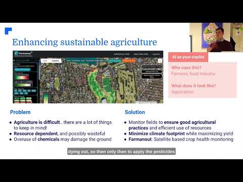
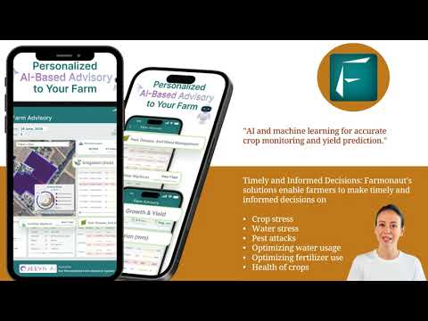
Farmonaut: Pioneering Satellite-Based Farm Management
In the realm of satellite crop monitoring and precision agriculture, Farmonaut stands out as a pioneering force. By leveraging cutting-edge technology and data-driven insights, Farmonaut is making precision agriculture accessible and affordable for farmers worldwide.
Key features of Farmonaut’s platform include:
- Real-time crop health monitoring using satellite imagery
- AI-powered advisory system for personalized farm management
- Blockchain-based traceability solutions for supply chain transparency
- Advanced analytics for yield prediction and resource optimization
- Integration with weather forecasting and climate data for informed decision-making
Farmonaut’s commitment to innovation and accessibility is helping to bridge the gap between traditional farming practices and the digital agriculture revolution.
Explore Farmonaut’s solutions:


Comparison: Traditional Farming vs. Farmonaut Satellite System
| Aspect | Traditional Farming | Farmonaut Satellite System |
|---|---|---|
| Crop Health Monitoring | Manual, infrequent, subjective | Daily, precise, data-driven |
| Resource Optimization | Based on experience, often excessive | Precise, based on real-time data |
| Yield Prediction | Rough estimates, often inaccurate | AI-powered, highly accurate |
| Stress Detection | Visual inspection, often too late | Early warning system, proactive |
| Data-Driven Decision Making | Limited, based on past experience | Comprehensive, based on real-time insights |
| Time and Cost Savings | Baseline | Up to 30% reduction in input costs |
| Environmental Impact | Higher resource use, potential waste | Optimized resource use, reduced environmental footprint |
Conclusion: Embracing the Future of Agriculture
As we’ve explored throughout this article, the integration of satellite crop monitoring, NDVI analysis, and precision agriculture technologies is revolutionizing the farming industry. These advancements are not just improving productivity and efficiency; they’re also paving the way for more sustainable and resilient agricultural practices.
By embracing these technologies, farmers can:
- Make more informed decisions based on real-time data
- Optimize resource use, reducing waste and environmental impact
- Increase crop yields while maintaining soil health
- Adapt more effectively to changing climate conditions
- Contribute to global food security through improved productivity
As we look to the future, it’s clear that the continued development and adoption of these technologies will play a crucial role in meeting the growing global demand for food while preserving our planet’s resources. The agricultural revolution is here, and it’s being driven by the power of satellite technology and data-driven insights.

Farmonaut Subscriptions
Frequently Asked Questions (FAQ)
Q: What is satellite crop monitoring?
A: Satellite crop monitoring uses imagery from satellites to assess crop health, growth, and field conditions. It provides farmers with valuable insights for decision-making without the need for physical field inspections.
Q: How does NDVI analysis work?
A: NDVI (Normalized Difference Vegetation Index) analysis compares the amount of near-infrared light reflected by plants to the amount of red light absorbed. Healthy vegetation reflects more near-infrared light, resulting in higher NDVI values.
Q: Can satellite monitoring replace traditional field scouting?
A: While satellite monitoring provides valuable insights, it’s best used in conjunction with traditional field scouting. It can help focus scouting efforts on areas of concern identified by satellite data.
Q: How often is satellite data updated?
A: The frequency of updates depends on the satellite system used. Some platforms offer daily updates, while others may provide imagery every few days or weekly.
Q: Is satellite crop monitoring affordable for small farmers?
A: Yes, platforms like Farmonaut are making satellite crop monitoring accessible and affordable for farmers of all scales, including small-scale operations.
Q: How does precision agriculture contribute to sustainability?
A: Precision agriculture optimizes resource use, reducing waste and environmental impact. It allows for targeted application of water, fertilizers, and pesticides, promoting more sustainable farming practices.
Q: Can satellite monitoring detect pest infestations or diseases?
A: While satellite monitoring can’t directly identify specific pests or diseases, it can detect changes in crop health that may indicate pest or disease problems, allowing for early intervention.
Q: How accurate are crop yield predictions based on satellite data?
A: Yield predictions based on satellite data, combined with historical information and AI algorithms, can be highly accurate. However, factors like sudden weather events can still impact final yields.
Q: What types of crops can be monitored using satellite technology?
A: Most agricultural crops can be monitored using satellite technology, including grains, fruits, vegetables, and cash crops. The effectiveness may vary depending on the crop type and growth patterns.
Q: How does Farmonaut’s platform differ from other satellite monitoring services?
A: Farmonaut offers an integrated platform that combines satellite monitoring with AI-powered analytics, blockchain traceability, and personalized advisory services, making it a comprehensive solution for modern farming needs.