Revolutionizing California Farming: How Satellite Imagery and Precision Agriculture Are Transforming Crop Monitoring
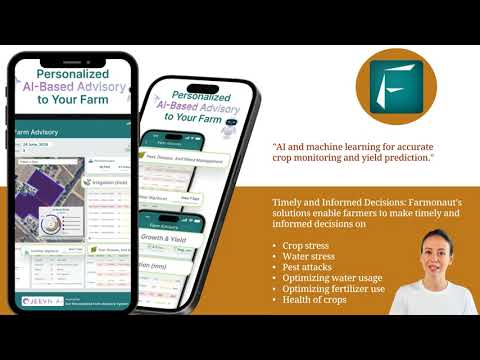
“Satellite imagery can detect up to 14 different spectral bands, enabling precise crop health analysis and stress detection.”
Welcome to the future of farming in California! We’re excited to take you on a journey exploring how satellite imagery and precision agriculture are revolutionizing crop monitoring and transforming traditional farming practices. At Farmonaut, we’re at the forefront of this agricultural revolution, leveraging cutting-edge technology to empower farmers and optimize crop production.
The Power of Satellite Imagery in Agriculture
Satellite imagery has become an indispensable tool in modern agriculture, offering farmers unprecedented insights into their fields from a bird’s-eye view. Here’s how satellite technology is changing the game for California farmers:
- High-Resolution Monitoring: Satellites like Landsat and MODIS capture detailed images of agricultural landscapes, providing farmers with a comprehensive view of their crops.
- Multispectral and Hyperspectral Imaging: These advanced imaging techniques allow us to analyze crop health, detect stress, and identify potential issues before they become visible to the naked eye.
- Frequent Data Updates: With regular satellite passes, we can monitor changes in crop conditions over time, enabling timely interventions and informed decision-making.
At Farmonaut, we harness the power of satellite imagery to provide farmers with real-time insights into their crops’ health and performance. Our advanced algorithms process multispectral data to generate actionable information for optimal farm management.

Precision Agriculture: The Future of Farming
Precision agriculture is transforming the way we approach farming in California. By combining satellite data with on-ground sensors and advanced analytics, we’re enabling farmers to make data-driven decisions that optimize yields and reduce resource consumption.
“Precision agriculture technologies can increase crop yields by 10-15% while reducing water usage by up to 30%.”
Key components of precision agriculture include:
- Variable Rate Technology (VRT): Allows for precise application of inputs like water, fertilizers, and pesticides based on specific field conditions.
- GPS-Guided Machinery: Enables accurate planting, spraying, and harvesting, reducing overlap and improving efficiency.
- Soil Sampling and Mapping: Provides detailed information about soil health and nutrient levels across different parts of a field.
Farmonaut’s precision agriculture solutions integrate seamlessly with satellite data to provide a comprehensive farm management system. Our web app and mobile applications make it easy for farmers to access this powerful technology right from their fingertips.

Remote Sensing: The Eyes in the Sky
Remote sensing technology is at the heart of modern agricultural monitoring. By capturing data across various spectral bands, we can gain insights into crop health, soil moisture, and even predict yields with remarkable accuracy.
Key applications of remote sensing in California agriculture include:
- Vegetation Index Mapping: Using indices like NDVI (Normalized Difference Vegetation Index) to assess crop vigor and health.
- Thermal Imaging: Detecting temperature variations in crops to identify stress and irrigation needs.
- Soil Moisture Assessment: Analyzing soil moisture levels to optimize irrigation schedules and prevent water stress.
Farmonaut’s advanced remote sensing capabilities provide California farmers with a competitive edge, enabling them to monitor vast areas efficiently and make informed decisions based on real-time data.
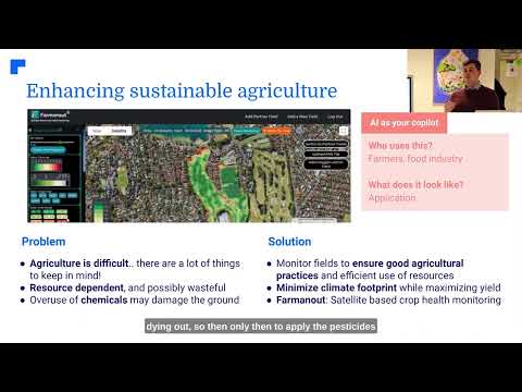
Crop Health Monitoring: A Data-Driven Approach
One of the most significant advantages of satellite-based agriculture is the ability to monitor crop health continuously and accurately. Our crop health monitoring system at Farmonaut uses a combination of spectral analysis and machine learning algorithms to provide detailed insights into crop conditions.
Benefits of satellite-based crop health monitoring include:
- Early Detection of Stress: Identify potential issues before they become visible, allowing for proactive management.
- Precision in Treatment: Target specific areas of the field that need attention, reducing overall input costs.
- Historical Analysis: Compare current crop health with historical data to identify trends and improve long-term strategies.
By leveraging these technologies, California farmers can significantly improve their crop management practices and boost overall productivity.

Yield Prediction: Forecasting the Future
Accurate yield prediction is crucial for farm planning and resource allocation. Farmonaut’s yield prediction models combine satellite imagery, historical data, and environmental factors to provide reliable forecasts for various crops across California.
Our yield prediction system offers:
- Early Estimates: Get yield projections weeks or even months before harvest.
- Field-Level Accuracy: Predict yields for specific areas within a field, accounting for variations in soil and growing conditions.
- Scenario Analysis: Evaluate potential yields under different weather conditions or management practices.
With these insights, farmers can make informed decisions about marketing, storage, and resource allocation well in advance of harvest time.
Agricultural Land Use Mapping: Optimizing Space
Efficient land use is critical in California’s diverse agricultural landscape. Our satellite-based land use mapping services help farmers and policymakers make the most of available resources.
Key features of our land use mapping include:
- Crop Type Classification: Accurately identify and map different crop types across large areas.
- Change Detection: Monitor changes in land use over time to track agricultural trends and urban expansion.
- Suitability Analysis: Assess land suitability for different crops based on soil, climate, and topographic factors.
These mapping capabilities support strategic planning at both the farm and regional levels, ensuring sustainable and productive use of California’s agricultural lands.
Integrating GIS in Agriculture
Geographic Information Systems (GIS) play a crucial role in modern precision agriculture. By combining satellite imagery with other spatial data, GIS enables complex analysis and visualization of agricultural information.
Applications of GIS in California agriculture include:
- Field Boundary Mapping: Accurately delineate field boundaries for precise management.
- Spatial Analysis: Identify patterns and relationships between various agricultural factors.
- Decision Support: Provide visual tools to aid in farm planning and management decisions.
Farmonaut’s GIS-integrated solutions offer California farmers powerful tools for spatial analysis and data-driven decision-making.
Smart Farming Technologies: Beyond Satellite Imagery
While satellite imagery forms the backbone of our precision agriculture solutions, we also integrate other smart farming technologies to provide a comprehensive management system:
- IoT Sensors: On-ground sensors that provide real-time data on soil moisture, temperature, and other critical parameters.
- Drone Technology: For high-resolution imagery and targeted applications in smaller areas.
- Weather Stations: Local weather monitoring to complement satellite-based observations.
By combining these technologies with our satellite-based systems, we offer California farmers a complete toolkit for precision agriculture.

The Farmonaut Advantage: Transforming California Agriculture
At Farmonaut, we’re committed to revolutionizing farming practices in California through our innovative satellite-based solutions. Our platform offers:
- Real-Time Monitoring: Access up-to-date information on crop health and field conditions.
- User-Friendly Interface: Easy-to-use web and mobile apps for seamless farm management.
- Customized Insights: Tailored recommendations based on your specific crop and location.
- Data Integration: Combine satellite data with on-ground observations for comprehensive analysis.
Experience the power of satellite-based agriculture with Farmonaut. Visit our web app or download our mobile applications to get started:


Comparison: Traditional Farming vs. Farmonaut Satellite System in California
| Aspect | Traditional Farming | Farmonaut Satellite System |
|---|---|---|
| Crop Health Monitoring | Visual inspection, weekly | Daily satellite imagery, AI-powered analysis |
| Yield Prediction | Based on historical data, 60-70% accuracy | AI models with 85-90% accuracy, updated weekly |
| Stress Detection | Visual signs, often too late | Early detection using spectral analysis |
| Water Management | Schedule-based irrigation | Precision irrigation based on real-time soil moisture data |
| Fertilizer Application | Uniform application across fields | Variable rate application based on nutrient maps |
| Time Savings | Baseline | Estimated 15-20 hours saved per week |
| Cost Savings | Baseline | Estimated 20-30% reduction in input costs |
| Environmental Impact | Higher water and chemical usage | 25-35% reduction in water use, 15-25% reduction in chemical use |
The Future of Agriculture: Where Space Meets Earth
As we look to the future, the integration of satellite technology and precision agriculture will continue to transform farming practices in California and beyond. Emerging trends include:
- AI and Machine Learning: More sophisticated algorithms for crop analysis and prediction.
- Hyperspectral Imaging: Even more detailed spectral data for advanced crop health assessment.
- Blockchain Integration: Enhancing traceability and transparency in the agricultural supply chain.
Farmonaut is committed to staying at the forefront of these technological advancements, continually improving our services to meet the evolving needs of California farmers.
Embrace the Future of Farming with Farmonaut
The revolution in California farming is here, and it’s powered by satellite imagery and precision agriculture. By embracing these technologies, farmers can optimize their operations, increase yields, and contribute to more sustainable agricultural practices.
Ready to transform your farming operations? Explore Farmonaut’s satellite-based solutions today:
- Try our web app for comprehensive farm management
- Integrate our data into your systems with our API
- Check out our API Developer Docs for technical information
Join us in revolutionizing agriculture, one field at a time. With Farmonaut, the future of farming is at your fingertips.
FAQs
Q: How often is satellite imagery updated in Farmonaut’s system?
A: Our satellite imagery is typically updated every 3-5 days, depending on weather conditions and satellite availability.
Q: Can Farmonaut’s technology be used for all types of crops?
A: Yes, our technology is adaptable to various crop types, from row crops to orchards and vineyards.
Q: How accurate are Farmonaut’s yield predictions?
A: Our yield predictions typically have an accuracy rate of 85-90%, which improves as we get closer to harvest time.
Q: Is Farmonaut’s system suitable for small-scale farmers?
A: Absolutely! We offer scalable solutions that cater to farms of all sizes, from small family operations to large commercial enterprises.
Q: How does Farmonaut ensure data security and privacy?
A: We employ robust encryption and security protocols to protect all user data, ensuring your farm information remains private and secure.