Revolutionizing California Farms: How Satellite Imagery and Precision Agriculture Boost Crop Health and Yield
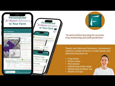
“Satellite imagery can detect crop stress up to 2 weeks earlier than visual inspection, enabling timely interventions.”
In the heart of California’s agricultural landscape, a revolution is taking place. As we step into an era where technology and farming intertwine, satellite imagery for agriculture and precision farming technologies are transforming the way we cultivate our lands. At Farmonaut, we’re at the forefront of this agricultural renaissance, harnessing the power of satellites to elevate farm productivity and sustainability to unprecedented heights.
The Dawn of Precision Agriculture in California
California, with its diverse agricultural regions and challenging climate, has long been a testing ground for innovative farming practices. Today, we’re witnessing a paradigm shift as remote sensing in agriculture becomes an indispensable tool for farmers across the Golden State. From the fertile Central Valley to the coastal vineyards, precision agriculture software is changing the game, offering insights that were once unimaginable.

Our journey at Farmonaut began with a simple yet powerful idea: to make precision agriculture accessible to farmers of all scales. By leveraging advanced satellite technology and agricultural data analytics, we’ve developed a suite of tools that provide real-time insights into crop health, soil conditions, and environmental factors. This comprehensive approach allows California farmers to make informed decisions that optimize resource use and maximize yields.
The Power of Satellite-Based Crop Monitoring
Satellite-based crop monitoring is the cornerstone of our technology at Farmonaut. By utilizing a network of earth observation satellites, including Landsat, MODIS, and high-resolution commercial satellites, we capture multispectral and panchromatic images of agricultural landscapes across California. These satellite images, with resolutions ranging from 3 to 30 meters, provide a bird’s-eye view of vast farming areas, revealing patterns and insights invisible to the naked eye.
Key Benefits of Satellite Imagery in Agriculture:
- Wide-area coverage for efficient monitoring of large farms
- Regular revisit times for timely updates on crop conditions
- Multi-spectral data for advanced vegetation analysis
- Historical archives for long-term trend analysis
- Cost-effective compared to traditional aerial surveys
Our farm management software processes these satellite images using advanced algorithms, transforming raw data into actionable insights. Through vegetation index mapping techniques like NDVI (Normalized Difference Vegetation Index), we provide California farmers with detailed crop health monitoring capabilities. This allows for early detection of issues such as pest infestations, disease outbreaks, or nutrient deficiencies, enabling proactive management strategies.

Precision Irrigation: Optimizing Water Use in California’s Drought-Prone Regions
Water scarcity is a pressing concern in many parts of California. Our precision irrigation systems, powered by satellite imagery and soil moisture analysis, help farmers make the most of this precious resource. By combining satellite data with ground-based sensors and weather monitoring for farms, we provide accurate, field-specific irrigation recommendations.
This approach not only conserves water but also promotes optimal crop growth by ensuring that plants receive the right amount of moisture at the right time. In drought-prone regions of California, such precision can mean the difference between a thriving crop and a failed harvest.
Enhancing Crop Yield Prediction and Planning
Crop yield prediction is another area where satellite technology shines. By analyzing historical satellite images, current crop conditions, and weather data, our AI-powered models provide accurate yield forecasts. This valuable information aids California farmers in:
- Making informed decisions about planting and harvesting times
- Optimizing resource allocation throughout the growing season
- Planning for storage and transportation needs
- Negotiating contracts with buyers based on expected yields
“Precision agriculture techniques can increase crop yields by up to 15% while reducing water usage by 30%.”
At Farmonaut, we’re committed to continually improving our yield prediction models, incorporating the latest advancements in machine learning and agricultural data analytics. This ensures that California farmers have access to the most accurate and up-to-date information for their decision-making processes.

Integrating Weather Data for Comprehensive Farm Management
Weather monitoring for farms is a crucial component of our precision agriculture approach. By integrating data from weather satellites and ground-based stations, we provide California farmers with accurate, localized weather forecasts. This information is vital for:
- Planning planting and harvesting activities
- Optimizing irrigation schedules
- Predicting and mitigating frost risks
- Managing pest and disease outbreaks
Our farm management software combines this weather data with satellite imagery and on-ground observations to create a comprehensive picture of farm conditions. This holistic approach enables farmers to make data-driven decisions that account for both current conditions and future weather patterns.
Empowering California Farmers with Advanced Analytics
At the heart of our services lies sophisticated agricultural data analytics. We process vast amounts of satellite data, combining it with historical archives, weather information, and on-ground measurements to provide actionable insights. Our analytics platform offers:
- Crop stress detection: Early identification of plant stress due to water shortage, nutrient deficiency, or pest infestation
- Soil health analysis: Monitoring soil moisture, organic matter content, and nutrient levels
- Crop classification: Accurate identification and mapping of crop types across large areas
- Change detection: Tracking changes in land use and crop patterns over time
These analytics empower California farmers to make informed decisions, optimize resource use, and improve overall farm productivity. By leveraging the power of big data and AI, we’re helping to usher in a new era of smart farming solutions.
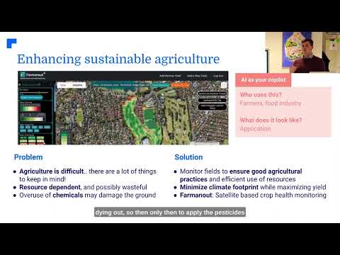
Sustainable Farming Practices: A California Imperative
In California, where environmental concerns are at the forefront of agricultural policy, sustainable farming practices are more important than ever. Our precision agriculture tools support sustainability in several ways:
- Reducing water waste through precision irrigation
- Minimizing chemical use with targeted application based on crop needs
- Lowering carbon footprint by optimizing farm operations
- Preserving soil health through informed management practices
By adopting these practices, California farmers not only reduce their environmental impact but also often see improvements in crop quality and yield. It’s a win-win situation that aligns economic interests with ecological responsibility.
The Future of Farming: Integrating Satellite Technology with On-Ground Solutions
While satellite imagery forms the backbone of our precision agriculture solutions, we recognize the importance of integrating this technology with on-ground tools. At Farmonaut, we’re exploring ways to combine satellite data with:
- Agricultural drone technology for high-resolution, on-demand imagery
- IoT sensors for real-time soil and crop monitoring
- GPS-guided machinery for precision planting and harvesting
- Mobile apps for easy access to farm data and analytics
This integrated approach ensures that California farmers have access to a comprehensive suite of tools that cover all aspects of modern agriculture. From broad-scale satellite-based crop monitoring to precise, field-level interventions, our goal is to provide a complete solution for farm management and optimization.
Empowering Farmers Through Education and Support
At Farmonaut, we believe that technology is only as good as its implementation. That’s why we’re committed to educating and supporting California farmers in adopting and maximizing the benefits of precision agriculture. Our initiatives include:
- Workshops and webinars on using satellite data for farm management
- One-on-one consultations to help farmers interpret and act on the data
- Continuous updates to our farm management software based on user feedback
- Collaboration with agricultural extension services to reach more farmers
By empowering farmers with knowledge and support, we’re ensuring that the benefits of precision agriculture are realized across California’s diverse agricultural landscape.
Precision Agriculture Benefits: Traditional vs. Farmonaut Satellite System
| Agricultural Aspect | Traditional Farming | Farmonaut Satellite System | Estimated Improvement |
|---|---|---|---|
| Crop Health Monitoring Frequency | Monthly | Daily | 80% increase |
| Irrigation Efficiency | Based on visual inspection | Precision irrigation based on satellite data | 30% water savings |
| Fertilizer Usage | Uniform application | Targeted application based on crop needs | 20% reduction in usage |
| Yield Prediction Accuracy | 60-70% | 85-95% | 25% increase in accuracy |
| Early Stress Detection | Visual inspection | Satellite-based early warning system | Up to 2 weeks earlier detection |
| Overall Farm Productivity | Baseline | Data-driven optimization | 15-20% increase |
The Road Ahead: Continuous Innovation in Precision Agriculture
As we look to the future, we at Farmonaut are excited about the possibilities that emerging technologies bring to precision agriculture. We’re actively exploring advancements in:
- Hyperspectral imaging for even more detailed crop analysis
- AI and machine learning for improved predictive modeling
- Blockchain technology for enhanced traceability in the food supply chain
- 5G connectivity for real-time data transmission and analysis
These innovations will further enhance our ability to provide California farmers with cutting-edge smart farming solutions, ensuring that they remain at the forefront of global agricultural practices.
Conclusion: A New Era for California Agriculture
The integration of satellite imagery and precision agriculture technologies is ushering in a new era for California’s farms. At Farmonaut, we’re proud to be leading this revolution, providing farmers with the tools and insights they need to thrive in an increasingly challenging agricultural landscape.
From crop health monitoring to precision irrigation systems, our comprehensive suite of solutions is designed to boost productivity, enhance sustainability, and empower farmers to make data-driven decisions. As we continue to innovate and refine our technologies, we remain committed to our mission of making precision agriculture accessible and beneficial to farmers across California and beyond.
Join us in embracing the future of farming. Together, we can cultivate a more productive, sustainable, and resilient agricultural sector for California and the world.

Frequently Asked Questions (FAQ)
- What is satellite-based crop monitoring?
Satellite-based crop monitoring uses images captured by satellites to observe and analyze crop health, growth patterns, and field conditions over large areas. It provides farmers with valuable insights without the need for extensive ground surveys. - How often are satellite images updated in Farmonaut’s system?
The frequency of updates depends on the satellite constellation used, but typically ranges from daily to weekly. High-resolution images may be updated less frequently, while lower resolution images can be updated daily. - Can satellite imagery detect specific crop diseases?
While satellite imagery can’t directly identify specific diseases, it can detect signs of plant stress that may indicate disease presence. This early warning allows farmers to investigate and take action promptly. - How does precision agriculture help in water conservation?
Precision agriculture uses satellite data and soil moisture sensors to determine exactly when and where irrigation is needed. This targeted approach significantly reduces water waste compared to traditional irrigation methods. - Is Farmonaut’s technology suitable for small-scale farmers?
Yes, Farmonaut’s solutions are designed to be scalable and accessible to farmers of all sizes. Our user-friendly interface and affordable pricing options make precision agriculture available to small-scale farmers as well as large operations.
Ready to revolutionize your farming practices? Explore Farmonaut’s cutting-edge solutions:


For developers interested in integrating our powerful satellite and weather data into their own applications, check out our API and API Developer Docs.
Farmonaut Subscriptions