Revolutionizing Precision Agriculture: Harnessing Historical NDVI Data for Advanced Crop Monitoring and Analysis
“Farmonaut’s API provides access to NDVI time series data dating back to 2001, offering over 20 years of historical vegetation insights.”
In the ever-evolving landscape of agriculture, precision farming has emerged as a game-changing approach to optimize crop yields, conserve resources, and enhance overall farm productivity. At the heart of this revolution lies the power of historical NDVI (Normalized Difference Vegetation Index) data, a cornerstone of satellite vegetation monitoring. Today, we’ll delve deep into how Farmonaut’s cutting-edge agritech solution is transforming the way farmers and agricultural professionals leverage this invaluable data for advanced crop health monitoring and analysis.

Understanding NDVI and Its Significance in Agriculture
Before we dive into the intricacies of historical NDVI data, let’s establish a solid foundation by understanding what NDVI is and why it’s crucial for modern agriculture.
NDVI, or Normalized Difference Vegetation Index, is a numerical indicator that uses the visible and near-infrared bands of the electromagnetic spectrum to analyze remote sensing measurements and assess whether the observed target contains live green vegetation. In simpler terms, it’s a way to measure the health and vigor of plants from space.
- NDVI values range from -1 to +1
- Higher values indicate healthier vegetation
- Lower values suggest stressed or sparse vegetation
The significance of NDVI in agriculture cannot be overstated. It allows farmers and agronomists to:
- Monitor crop health throughout the growing season
- Detect stress caused by drought, pests, or diseases
- Predict crop yields
- Optimize irrigation and fertilizer application
- Make informed decisions about harvest timing
The Power of Historical NDVI Data
While real-time NDVI data is undoubtedly valuable, the true power of this technology lies in its historical context. By analyzing NDVI time series data dating back to 2001, we can uncover long-term trends, patterns, and anomalies that provide unparalleled insights into vegetation dynamics.
Historical NDVI data enables us to:
- Compare current crop performance with previous seasons
- Identify areas of consistent high or low productivity
- Detect gradual changes in land use or climate impacts
- Establish baseline vegetation health for different regions
- Analyze the effects of various management practices over time
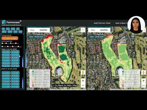
With Farmonaut’s innovative API, accessing and leveraging this wealth of historical data has never been easier. Our platform combines imagery from three major satellite sources: Landsat, Sentinel, and MODIS, ensuring comprehensive coverage and robust analysis capabilities.
Farmonaut’s NDVI API: A Game-Changer for Precision Agriculture
At Farmonaut, we’re committed to making precision agriculture accessible and affordable for farmers worldwide. Our NDVI API is a testament to this commitment, offering a powerful tool that puts the power of satellite-based crop monitoring directly into the hands of agricultural professionals.
Key Features of Farmonaut’s NDVI API:
- Access to NDVI time series data from 2001 to present
- Daily updates for real-time monitoring
- Flexible parameters for customized data retrieval
- Support for polygon areas, enabling precise field-level analysis
- Multiple satellite sources (Landsat, Sentinel, MODIS) for comprehensive coverage
- Essential statistical metrics for in-depth analysis
By leveraging our API, users can integrate powerful NDVI analysis capabilities into their existing farm management systems or develop custom applications tailored to their specific needs.
Explore our API and API Developer Docs to get started with Farmonaut’s NDVI solution today!

Practical Applications of Historical NDVI Data in Agriculture
The applications of historical NDVI data in agriculture are vast and varied. Let’s explore some of the most impactful ways farmers and agricultural professionals can leverage this valuable resource:
- Crop Performance Benchmarking: Compare current crop health and vigor against historical averages to identify areas of improvement or potential issues.
- Long-term Trend Analysis: Detect gradual changes in soil health, climate impacts, or the effectiveness of conservation practices over extended periods.
- Yield Prediction: Utilize historical NDVI patterns to develop more accurate yield prediction models, enabling better planning and resource allocation.
- Pest and Disease Monitoring: Identify recurring patterns of pest infestations or disease outbreaks by analyzing historical vegetation health data.
- Irrigation Optimization: Fine-tune irrigation strategies based on long-term vegetation health trends and water stress patterns.
- Climate Change Impact Assessment: Evaluate the effects of changing climate patterns on crop productivity and adapt farming practices accordingly.
“The API leverages imagery from three major satellite sources: Landsat, Sentinel, and MODIS, for comprehensive vegetation index analysis.”
Comparing Satellite Sources: Landsat, Sentinel, and MODIS
One of the key strengths of Farmonaut’s NDVI API is its ability to leverage data from multiple satellite sources. Each of these platforms offers unique advantages for agricultural remote sensing. Let’s compare their characteristics:
| Satellite Source | Spatial Resolution | Temporal Resolution | Historical Data Availability | Key Applications in Agriculture |
|---|---|---|---|---|
| Landsat | 30m | 16 days | Since 1972 | Long-term trend analysis, large-scale land use changes |
| Sentinel | 10m | 5 days | Since 2015 | Precise field-level monitoring, crop type mapping |
| MODIS | 250m – 1km | Daily | Since 2000 | Regional vegetation monitoring, rapid change detection |
By combining data from these diverse sources, Farmonaut’s API provides a comprehensive view of vegetation health across various spatial and temporal scales.
Advanced Analysis Techniques with Historical NDVI Data
The true power of historical NDVI data lies in the advanced analysis techniques it enables. Here are some sophisticated approaches that agricultural professionals can leverage:
- Time Series Decomposition: Break down NDVI time series into seasonal, trend, and residual components to isolate long-term changes from cyclical patterns.
- Anomaly Detection: Identify unusual vegetation patterns that deviate from historical norms, potentially indicating stress or management issues.
- Phenology Analysis: Study the timing of key growth stages (e.g., green-up, peak, senescence) and how they’ve changed over time.
- Change Point Detection: Pinpoint significant shifts in vegetation health or land use practices over extended periods.
- Spatial-Temporal Clustering: Group areas with similar NDVI patterns to identify zones with consistent performance or challenges.
These advanced techniques allow for a deeper understanding of crop dynamics and enable more informed decision-making in precision agriculture.

Integrating NDVI Data with Other Agricultural Insights
While NDVI is a powerful indicator on its own, its value is significantly enhanced when combined with other agricultural data sources. Farmonaut’s platform allows for seamless integration of NDVI insights with complementary data, including:
- Weather Data: Correlate NDVI trends with precipitation, temperature, and other meteorological factors.
- Soil Moisture: Analyze the relationship between vegetation health and soil water content.
- Crop Type Maps: Tailor NDVI analysis to specific crop varieties and their unique growth patterns.
- Topography: Understand how elevation and slope influence vegetation health over time.
- Management Practices: Evaluate the long-term impacts of different farming techniques on crop performance.
By combining these diverse data sources, farmers and agronomists can gain a holistic view of their agricultural systems and make more informed decisions.
The Future of Precision Agriculture with Historical NDVI Data
As we look to the future, the role of historical NDVI data in precision agriculture is set to become even more pivotal. Emerging technologies and analytical approaches are opening up new possibilities for leveraging this valuable resource:
- Machine Learning and AI: Develop predictive models that can forecast crop performance based on historical NDVI patterns and current conditions.
- Internet of Things (IoT) Integration: Combine satellite-based NDVI data with ground-level sensor networks for more accurate and localized insights.
- Blockchain for Data Integrity: Ensure the traceability and authenticity of historical NDVI data for improved decision-making and compliance.
- Augmented Reality (AR) Visualization: Overlay historical NDVI trends on real-time field views for intuitive analysis and decision support.
- Precision Robotics: Guide autonomous agricultural robots using historical NDVI data to optimize tasks like targeted spraying or harvesting.
At Farmonaut, we’re committed to staying at the forefront of these technological advancements, continuously enhancing our NDVI API to meet the evolving needs of modern agriculture.
Getting Started with Farmonaut’s NDVI Solution
Ready to harness the power of historical NDVI data for your agricultural operations? Farmonaut offers a range of solutions to suit your needs:
- API Access: Integrate our powerful NDVI data directly into your existing systems or custom applications.
- Web Application: Access user-friendly NDVI analysis tools through our intuitive web interface.
- Mobile Apps: Monitor your crops on-the-go with our Android and iOS applications.
Explore our offerings and start revolutionizing your approach to precision agriculture today!


Subscription Options
Frequently Asked Questions
Q: How often is the NDVI data updated?
A: Our NDVI data is updated daily, ensuring you have access to the most current information for your decision-making processes.
Q: Can I access historical NDVI data for any location globally?
A: Yes, our API provides global coverage, allowing you to retrieve historical NDVI data for any specified polygon area worldwide.
Q: What file formats are supported for NDVI data export?
A: Our API supports various export formats, including GeoTIFF, which is ideal for further GIS analysis and integration with other spatial data.
Q: How far back does the historical NDVI data go?
A: Our historical NDVI data dates back to 2001, providing over two decades of vegetation index information for comprehensive trend analysis.
Q: Is cloud cover accounted for in the NDVI calculations?
A: Yes, our system accounts for cloud cover and provides information on the percentage of clear pixels in each image, ensuring data reliability.
Conclusion
Historical NDVI data has emerged as a cornerstone of modern precision agriculture, offering unparalleled insights into crop health, productivity, and long-term trends. By harnessing the power of this valuable resource through Farmonaut’s cutting-edge API and analysis tools, farmers and agricultural professionals can make more informed decisions, optimize resource use, and drive sustainable farming practices.
As we continue to push the boundaries of agricultural technology, the integration of historical NDVI data with advanced analytics, AI, and IoT solutions promises to unlock even greater potential for optimizing crop yields and ensuring food security for future generations.
Embrace the future of precision agriculture with Farmonaut’s comprehensive NDVI solutions. Whether you’re a small-scale farmer, a large agribusiness, or an agricultural researcher, our platform provides the tools and insights you need to thrive in an increasingly data-driven agricultural landscape.
Start your journey towards more efficient, productive, and sustainable farming today with Farmonaut’s historical NDVI data and advanced crop monitoring solutions!