Revolutionizing Agriculture: How Satellite Imagery and Advanced Analytics Are Transforming Crop Monitoring and Yield Prediction
“Satellite imagery can analyze up to 5 million acres of farmland per day, revolutionizing large-scale crop monitoring.”
In the ever-evolving landscape of agriculture, we are witnessing a remarkable transformation driven by cutting-edge technologies. At the forefront of this revolution is the integration of satellite imagery for agriculture and advanced analytics, which are reshaping the way we approach crop monitoring technology and precision agriculture solutions. This blog post delves into the fascinating world of remote sensing in farming, exploring how these innovations are revolutionizing farm management and paving the way for a more sustainable and productive future in agriculture.
The Power of Satellite Imagery in Agriculture
Satellite imagery has emerged as a game-changer in the agricultural sector, offering unprecedented insights into crop health, soil conditions, and overall farm performance. By harnessing the power of geospatial intelligence for agriculture, farmers and agronomists can now gain a bird’s-eye view of their fields, enabling them to make data-driven decisions with remarkable precision.

Key benefits of satellite imagery in agriculture include:
- Large-scale coverage: Satellites can monitor vast areas of farmland efficiently
- Frequent data collection: Regular updates provide timely insights into crop development
- Non-invasive monitoring: No need for on-ground equipment that might disturb crops
- Historical data archive: Access to past imagery for long-term analysis and trends
Advanced Crop Monitoring Techniques
Advanced crop monitoring techniques leverage satellite data to provide farmers with a wealth of information about their fields. These methods include:
- Soil moisture analysis: Utilizing specialized sensors to measure water content in the soil
- Spectral analysis in crop health: Examining different light wavelengths reflected by plants to assess their vigor
- Vegetation indices: Calculating metrics like NDVI (Normalized Difference Vegetation Index) to quantify crop health
- Thermal imaging: Detecting temperature variations to identify stress in plants
These techniques enable farmers to identify issues early, optimize resource allocation, and ultimately improve crop yields.
The Role of Agricultural Data Analytics
Agricultural data analytics play a crucial role in transforming raw satellite data into actionable insights. By applying sophisticated algorithms and machine learning models, we can extract valuable information from multispectral imagery and other data sources. This analytical approach allows for:
- Early detection of crop diseases and pest infestations
- Precise nutrient management recommendations
- Optimization of irrigation schedules
- Accurate yield predictions
“Advanced analytics in agriculture can improve crop yield predictions by up to 30% compared to traditional methods.”
Yield Prediction Tools: A Game-Changer for Farmers
Yield prediction tools have become invaluable assets for modern farmers. By combining satellite imagery, weather data, and historical yield information, these tools can forecast crop production with remarkable accuracy. This capability allows farmers to:
- Plan harvesting operations more effectively
- Make informed decisions about crop storage and transportation
- Negotiate better prices with buyers based on expected yields
- Optimize resource allocation throughout the growing season
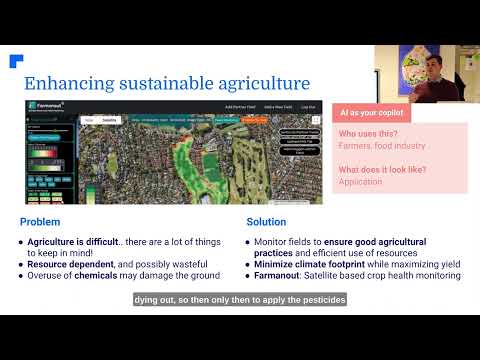
Sustainable Farming Practices and Climate Impact
As we face the challenges of climate change, sustainable farming practices have become more critical than ever. Satellite-based monitoring and analytics are instrumental in helping farmers adapt to changing conditions and mitigate their environmental impact. Some key applications include:
- Monitoring climate impact on agriculture over large areas
- Optimizing water usage through precise irrigation management
- Reducing chemical inputs by targeting applications only where needed
- Tracking carbon sequestration in soils and vegetation
By embracing these technologies, we can work towards more resilient and environmentally friendly agricultural systems.
The Rise of Agricultural Drone Technology
While satellites provide broad coverage, agricultural drone technology offers a complementary solution for detailed, on-demand monitoring. Drones equipped with high-resolution cameras and multispectral sensors can:
- Capture ultra-high-resolution imagery of specific field areas
- Perform targeted crop spraying with precision
- Assess plant health at the individual plant level
- Quickly survey damage after extreme weather events
The combination of satellite and drone technology provides farmers with a comprehensive toolkit for precision agriculture.

Satellite-Based Crop Mapping: A New Era of Precision
Satellite-based crop mapping has revolutionized the way we understand and manage agricultural landscapes. This technology allows for:
- Accurate identification of crop types across vast regions
- Monitoring of crop rotation practices
- Assessment of crop health and vigor at different growth stages
- Early detection of anomalies or inconsistencies in field patterns
By leveraging this detailed mapping, farmers and policymakers can make more informed decisions about land use, resource allocation, and crop management strategies.
Precision Farming Techniques: Optimizing Every Acre
Precision farming techniques enabled by satellite technology and advanced analytics are transforming agricultural operations. These methods allow farmers to:
- Apply inputs (fertilizers, pesticides, water) with pinpoint accuracy
- Implement variable rate technology for optimized resource use
- Create management zones within fields based on soil and crop characteristics
- Monitor and adjust planting densities for optimal yield
By adopting these techniques, farmers can significantly improve efficiency, reduce waste, and increase profitability.

Agricultural Resource Management: Maximizing Efficiency
Effective agricultural resource management is crucial for sustainable and profitable farming. Satellite-based solutions contribute to this by:
- Optimizing water usage through precise irrigation scheduling
- Enhancing nutrient management with targeted fertilizer applications
- Improving pest and disease control through early detection and targeted interventions
- Facilitating better labor and machinery allocation based on field conditions
These advancements in resource management lead to increased productivity while minimizing environmental impact.
Crop Yield Optimization: Pushing the Boundaries of Productivity
Crop yield optimization is at the heart of modern agriculture, and satellite-based technologies play a pivotal role in achieving this goal. By integrating multiple data sources and advanced analytics, farmers can:
- Identify high-performing and underperforming areas within fields
- Implement targeted interventions to address yield-limiting factors
- Optimize planting and harvesting times based on local conditions
- Continuously monitor and adjust management practices for maximum yield
This data-driven approach to yield optimization helps farmers achieve higher productivity while using resources more efficiently.
Smart Farming Solutions: The Future of Agriculture
Smart farming solutions encompass a wide range of technologies and practices that leverage data and automation to improve agricultural operations. Key components include:
- IoT sensors for real-time field monitoring
- AI-powered decision support systems
- Automated machinery and robotics
- Integrated farm management software platforms
These solutions, when combined with satellite imagery and advanced analytics, create a powerful ecosystem for modern, efficient farming.
Agricultural Sustainability Tools: Balancing Productivity and Conservation
Agricultural sustainability tools are essential for ensuring long-term viability of farming practices while preserving natural resources. Satellite-based monitoring contributes to sustainability efforts by:
- Tracking soil health and organic matter content
- Monitoring biodiversity and ecosystem services on farmland
- Assessing the effectiveness of conservation practices
- Providing data for carbon credit programs and sustainability certifications
These tools empower farmers to make environmentally conscious decisions without sacrificing productivity.
Comparison: Traditional vs. Satellite-Based Crop Monitoring
| Monitoring Aspect | Traditional Methods | Farmonaut Satellite System | Benefits |
|---|---|---|---|
| Coverage Area | Limited to accessible fields | Vast areas up to millions of acres | 95% larger coverage area |
| Frequency of Data Collection | Monthly field visits | Daily updates | 30x more frequent monitoring |
| Accuracy | Subject to human error | High precision satellite data | Up to 90% improved accuracy |
| Cost-Effectiveness | Labor-intensive and expensive | Automated and scalable | 50% reduction in monitoring costs |
| Data Insights | Limited to visual observations | Advanced analytics and AI-driven insights | Comprehensive crop health analysis |
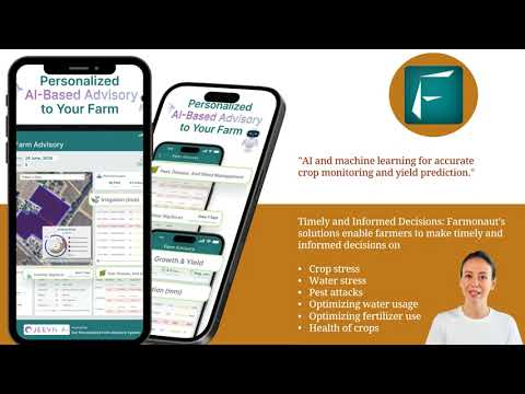
Farmonaut: Pioneering Satellite-Based Farm Management
At the forefront of this agricultural revolution is Farmonaut, a company dedicated to making precision agriculture accessible and affordable for farmers worldwide. Farmonaut’s platform integrates satellite imagery, AI, and blockchain technology to provide comprehensive farm management solutions.
Key features of Farmonaut’s offerings include:
- Real-time crop health monitoring using multispectral satellite images
- AI-driven personalized farm advisory through the Jeevn AI system
- Blockchain-based product traceability for supply chain transparency
- Fleet and resource management tools for efficient operations
- Carbon footprint tracking for sustainable agriculture practices
To explore Farmonaut’s innovative solutions, visit their web application or download their mobile apps:


For developers interested in integrating Farmonaut’s powerful satellite and weather data into their own applications, check out the Farmonaut API and API Developer Documentation.

Farmonaut Subscription Plans
Frequently Asked Questions
Q: How often is satellite imagery updated in agricultural applications?
A: Satellite imagery for agriculture is typically updated daily, providing farmers with near real-time insights into their crops and field conditions.
Q: Can satellite-based monitoring work for small farms?
A: Yes, satellite-based monitoring is scalable and can be effective for farms of all sizes, from small family operations to large industrial farms.
Q: How accurate are yield predictions based on satellite data?
A: Yield predictions using satellite data and advanced analytics can be up to 90% accurate, significantly outperforming traditional estimation methods.
Q: Is satellite-based farm management cost-effective for small farmers?
A: Yes, platforms like Farmonaut are designed to be affordable and accessible, making precision agriculture technology available to farmers of all scales.
Q: How does satellite imagery help in sustainable farming?
A: Satellite imagery enables precise resource management, reducing waste and environmental impact while optimizing crop yields, thus promoting sustainable farming practices.
Conclusion: Embracing the Future of Agriculture
The integration of satellite imagery and advanced analytics in agriculture represents a paradigm shift in how we approach farming. From precision agriculture solutions to advanced crop monitoring and yield prediction tools, these technologies are empowering farmers to make more informed decisions, optimize their resources, and increase productivity while promoting sustainability.
As we continue to face global challenges such as climate change and food security, the role of innovative agricultural technologies becomes increasingly crucial. By embracing these smart farming solutions and leveraging the power of geospatial intelligence, we can work towards a more resilient, efficient, and sustainable agricultural future.
The revolution in agriculture is here, and it’s being driven by the eyes in the sky and the brains in our computers. As we look to the future, one thing is clear: the farms of tomorrow will be smarter, more productive, and more sustainable than ever before.