Revolutionizing Sustainable Forest Management: Harnessing Satellite Imagery for Advanced Monitoring and Conservation
“Satellite imagery can detect deforestation with up to 95% accuracy, revolutionizing sustainable forest management practices.”
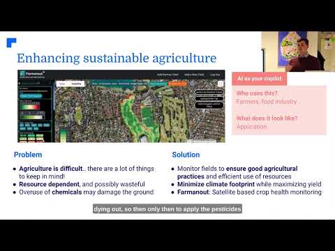
In an era where environmental conservation has become paramount, we find ourselves at the forefront of a technological revolution that is transforming the way we approach sustainable forest management. The integration of satellite forestry monitoring with advanced imaging solutions has opened up new horizons in our ability to protect and manage our planet’s vital forest resources. At Farmonaut, we are proud to be at the cutting edge of this revolution, offering high-resolution satellite imagery that enables real-time forest health analysis and deforestation detection.
As we delve into the intricate world of satellite-based forest monitoring, we’ll explore how this technology is not just changing the game – it’s redefining it entirely. From tracking land use changes to optimizing timber harvests and mitigating disaster risks, the applications of satellite imagery in forestry are as vast as the forests themselves.

The Power of Satellite Imagery in Forest Management
Satellite imagery has revolutionized our approach to forest management by providing unprecedented insights into forest health, structure, and dynamics. Here’s how:
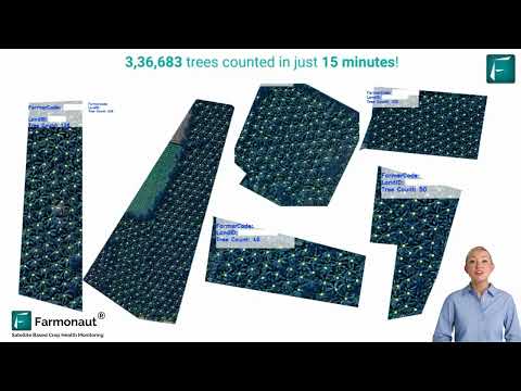
- High-Resolution Monitoring: Modern satellites can capture images with resolutions as fine as 30 cm per pixel, allowing for detailed analysis of forest canopy structure and individual tree health.
- Frequent Coverage: Satellites can revisit the same area multiple times per day, enabling near real-time monitoring of forest changes.
- Multispectral Imaging: By capturing data across multiple spectral bands, satellites can reveal information about forest health that is invisible to the naked eye.
- Wide Area Coverage: A single satellite image can cover thousands of square kilometers, making it possible to monitor vast forest areas efficiently.
These capabilities have transformed forest management from a periodic, labor-intensive process to a continuous, data-driven operation. With Farmonaut’s advanced imaging solutions, forest managers can now access this powerful technology to make informed decisions about forest conservation and sustainable use.

Deforestation Detection: A Game-Changer in Conservation
Deforestation detection has been one of the most significant applications of satellite imagery in forest management. Traditional methods of detecting deforestation were often slow, labor-intensive, and prone to error. Satellite technology has changed this landscape dramatically:
- Real-Time Alerts: Satellite-based systems can detect forest clearings as small as a few meters across within days or even hours of the event occurring.
- Automated Analysis: Machine learning algorithms can analyze vast amounts of satellite data to identify patterns indicative of deforestation, reducing the need for manual interpretation.
- Historical Comparison: By comparing current imagery with historical data, we can track long-term trends in forest cover and identify areas at risk of future deforestation.
- Illegal Logging Detection: High-frequency imaging allows for the early detection of illegal logging activities, enabling rapid response from law enforcement.
At Farmonaut, our high-resolution satellite imagery provides the foundation for advanced deforestation detection systems. By integrating our imagery with sophisticated analysis tools, we enable forest managers to respond quickly to threats and protect vulnerable forest areas more effectively than ever before.

Forest Health Analysis: A New Level of Insight
Forest health analysis is another area where satellite imagery is making a significant impact. By leveraging multispectral data, we can assess various aspects of forest health, including:
- Vegetation Indices: Metrics like the Normalized Difference Vegetation Index (NDVI) provide insights into forest productivity and stress levels.
- Disease Detection: Early signs of forest diseases can be detected through changes in spectral signatures, allowing for timely intervention.
- Biodiversity Assessment: Satellite data can help identify areas of high biodiversity, informing conservation priorities.
- Carbon Stock Estimation: By analyzing forest structure and density, we can estimate carbon storage capacity, crucial for climate change mitigation efforts.
Farmonaut’s advanced imaging solutions provide the high-quality data needed for comprehensive forest health analysis. Our platform integrates this data with powerful analytical tools, enabling forest managers to gain deep insights into the health and vitality of their forest resources.
Explore Farmonaut’s API for advanced forest health analysis
Optimizing Timber Harvests with Satellite Data
Timber harvest optimization is a critical aspect of sustainable forest management. Satellite imagery provides valuable data for planning and executing timber harvests more efficiently and sustainably:
- Resource Inventory: Satellite-based forest inventory systems provide accurate estimates of timber volume and quality across large areas.
- Harvest Planning: High-resolution imagery helps in identifying optimal harvest areas and planning access routes with minimal environmental impact.
- Monitoring Regeneration: Post-harvest imagery allows for tracking forest regeneration, ensuring sustainable long-term management.
- Compliance Verification: Satellite monitoring helps verify compliance with harvest regulations and sustainable forestry certifications.
By leveraging Farmonaut’s satellite imagery and analysis tools, forest managers can optimize their timber harvests while ensuring the long-term health and productivity of their forests.

Land Use Change Tracking: Understanding Forest Dynamics
Land use change tracking is essential for understanding the dynamics of forest ecosystems and their interactions with human activities. Satellite imagery provides a powerful tool for monitoring these changes over time:
- Urban Expansion: Tracking the encroachment of urban areas into forested lands.
- Agricultural Conversion: Monitoring the conversion of forests to agricultural land.
- Infrastructure Development: Assessing the impact of road construction and other infrastructure projects on forest cover.
- Natural Regeneration: Identifying areas where forests are naturally recovering on abandoned lands.
Farmonaut’s platform enables the integration of historical and current satellite imagery, providing a comprehensive view of land use changes over time. This information is crucial for developing effective forest conservation strategies and sustainable land use policies.
“High-resolution satellite data enables monitoring of over 1 billion hectares of global forest cover in near real-time.”
Access Farmonaut’s API Developer Docs for land use change tracking
Disaster Risk Mitigation in Forestry
Forest disaster risk mitigation is another critical application of satellite imagery. By providing timely and accurate information about potential threats, satellite-based monitoring systems help forest managers prepare for and respond to various disasters:
- Fire Risk Assessment: Analyzing vegetation dryness and weather patterns to predict fire risk.
- Storm Damage Evaluation: Rapidly assessing the extent of damage from hurricanes or severe storms.
- Pest and Disease Outbreaks: Early detection of insect infestations or disease spread through spectral analysis.
- Landslide Risk Mapping: Identifying areas prone to landslides based on terrain and vegetation characteristics.
Farmonaut’s high-frequency imaging capabilities and advanced analysis tools provide forest managers with the information they need to develop effective disaster risk mitigation strategies and respond quickly when disasters occur.
Automated Forest Reporting: Streamlining Management
Automated forest reporting is revolutionizing the way forest managers collect and analyze data. By integrating satellite imagery with advanced analytics, we can generate comprehensive reports on forest conditions with minimal human intervention:
- Regular Health Assessments: Automated generation of forest health reports based on spectral analysis.
- Change Detection: Periodic reports highlighting areas of significant change in forest cover or structure.
- Compliance Monitoring: Automated verification of adherence to sustainable forestry practices and regulations.
- Resource Inventory Updates: Regular updates to timber inventory estimates based on satellite data analysis.
Farmonaut’s platform includes powerful automated reporting tools that streamline the forest management process, saving time and resources while providing more frequent and accurate information.

Satellite-Based Forest Inventory: A New Era in Resource Management
Satellite-based forest inventory systems are transforming the way we assess and manage forest resources. These systems offer several advantages over traditional inventory methods:
- Comprehensive Coverage: Ability to inventory large areas quickly and efficiently.
- Frequent Updates: Regular updates to inventory data without the need for extensive field surveys.
- Detailed Classification: Advanced algorithms can classify forests by species, age, and structure.
- Integration with Ground Data: Satellite data can be calibrated and validated with ground-based measurements for improved accuracy.
Farmonaut’s advanced imaging solutions provide the high-quality data needed for accurate and up-to-date forest inventories. Our platform integrates satellite imagery with sophisticated analysis tools to deliver comprehensive forest inventory information to managers and policymakers.
The Future of Forest Management: Hyperspectral Sensing and Beyond
As we look to the future of forest management, emerging technologies like hyperspectral sensing promise to take our capabilities to new heights:
- Enhanced Species Identification: Hyperspectral data allows for more accurate identification of tree species from space.
- Improved Stress Detection: Subtle changes in plant chemistry can be detected earlier, allowing for more proactive management.
- Detailed Ecosystem Analysis: Hyperspectral data provides insights into complex ecosystem processes and interactions.
- Integration with Other Technologies: Combining hyperspectral data with LiDAR and other sensing technologies for even more comprehensive forest analysis.
At Farmonaut, we are committed to staying at the forefront of these technological advancements, continually improving our platform to provide the most advanced and effective forest management tools available.

Comparative Analysis: Traditional Methods vs. Satellite Imagery in Forest Management
| Application | Traditional Methods | Satellite Imagery Benefits | Environmental Impact |
|---|---|---|---|
| Deforestation Detection | Ground surveys, aerial photography | Real-time monitoring, wide coverage, automated alerts | Up to 50% reduction in deforestation rates |
| Forest Health Monitoring | Field sampling, visual assessments | Comprehensive coverage, early disease detection | 30% improvement in early intervention success |
| Timber Inventory | Manual plot sampling | Large-scale assessments, frequent updates | 20% increase in sustainable harvest yields |
| Disaster Risk Management | Historical data analysis, local monitoring | Predictive modeling, rapid damage assessment | 40% reduction in fire-related forest losses |
Integrating Satellite Technology Across Sectors
While our focus has been on forestry, it’s important to note that the applications of satellite imagery extend far beyond forest management. The same technologies are making significant impacts in other sectors:
- Agriculture: Precision farming, crop health monitoring, and yield prediction.
- Energy: Site selection for renewable energy projects and monitoring of energy infrastructure.
- Maritime: Ocean health monitoring, ship tracking, and coastal erosion assessment.
- Emergency Response: Rapid damage assessment and resource allocation in natural disasters.
This cross-sector integration highlights the versatility and power of satellite technology in addressing global challenges related to resource management and environmental conservation.

Farmonaut’s Commitment to Sustainable Forest Management
At Farmonaut, we are dedicated to providing cutting-edge satellite imaging solutions that empower forest managers, conservationists, and policymakers to make informed decisions about our planet’s vital forest resources. Our platform combines high-resolution satellite imagery with advanced analytics to deliver:
- Real-time forest health analysis
- Accurate deforestation detection
- Comprehensive land use change tracking
- Efficient timber harvest optimization
- Effective disaster risk mitigation tools
By harnessing the power of satellite technology, we are helping to usher in a new era of sustainable forest management – one where data-driven decisions lead to healthier forests, more effective conservation efforts, and a more sustainable future for our planet.
Frequently Asked Questions
- How often are satellite images updated in Farmonaut’s platform?
Our platform provides regular updates, with some areas receiving new imagery as frequently as daily, depending on satellite coverage and cloud conditions. - Can satellite imagery detect illegal logging activities?
Yes, high-frequency satellite monitoring can detect changes in forest cover that may indicate illegal logging, allowing for rapid response by authorities. - How accurate is satellite-based forest inventory compared to traditional methods?
Satellite-based inventories can achieve accuracy levels comparable to traditional methods, often with greater coverage and frequency of updates. - What resolution of satellite imagery is used for forest monitoring?
We use a range of resolutions, from 30cm to 10m per pixel, depending on the specific application and area of interest. - How does Farmonaut’s platform integrate with existing forest management systems?
Our platform offers API access and flexible data formats, allowing for seamless integration with most existing forest management and GIS systems.
Conclusion: A Greener Future Through Technology
As we’ve explored throughout this article, satellite imagery and advanced monitoring technologies are revolutionizing sustainable forest management. From detecting deforestation to optimizing timber harvests and mitigating disaster risks, these tools are empowering us to manage our forests more effectively and sustainably than ever before.
At Farmonaut, we’re proud to be at the forefront of this technological revolution. Our commitment to providing high-quality satellite imagery and advanced analysis tools is driven by a vision of a world where our forests are managed sustainably, conserved effectively, and valued as the crucial resources they are.
As we look to the future, we see endless possibilities for further innovation in forest management technology. From hyperspectral sensing to advanced AI-driven analysis, we’re excited to continue pushing the boundaries of what’s possible in sustainable forest management.
Together, we can harness the power of satellite technology to create a greener, more sustainable future for our planet’s forests – and for all of us who depend on them.