June 2023

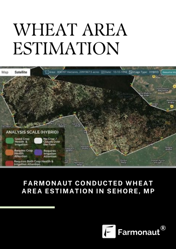
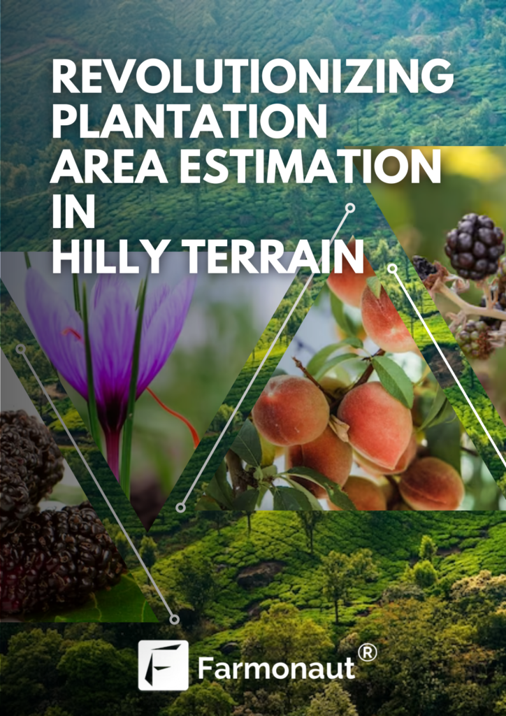
Revolutionizing Plantation Area Estimation in Hilly Terrain with Farmonaut

In the world of agriculture, accurate area estimation is a critical factor for effective planning, resource allocation, and yield prediction. This becomes particularly challenging in hilly areas, where traditional measurement methods are often impractical or inaccurate due to the uneven terrain. However, with technological advancements, innovative solutions like Farmonaut have emerged, revolutionizing area estimation for plantations in hilly regions. With its cutting-edge remote sensing and artificial intelligence capabilities, Farmonaut provides farmers and land managers with precise and efficient tools to measure the extent of plantations, leading to better decision-making and improved agricultural practices. The Challenges of Area Estimation in Hilly Areas Hilly areas pose unique challenges when it comes to accurate area estimation for plantations. The undulating terrain, steep slopes, and irregular shapes of the fields make it difficult to rely on traditional measuring techniques. Manual methods such as tape measurement or chain surveying are time-consuming, labor-intensive, and prone to errors. Additionally, estimating the area of plantations on hilly terrains often requires accessing difficult-to-reach locations, posing safety risks for field personnel. Emergence of Farmonaut Farmonaut is an innovative platform that harnesses the power of remote sensing and artificial intelligence (AI) to provide farmers with precise area estimation tools. By leveraging satellite imagery, aerial photography, and advanced algorithms, Farmonaut overcomes the limitations of traditional methods and offers an efficient and accurate solution for measuring plantation areas in hilly regions. How Farmonaut Works? Farmonaut employs a multi-step process to estimate plantation areas in hilly areas. The platform utilizes high-resolution satellite imagery or aerial photography to capture detailed information about the landscape. These images are then processed using AI algorithms to identify and delineate the boundaries of the plantations. By employing sophisticated image segmentation techniques, Farmonaut can distinguish vegetation from other elements in the landscape, enabling precise area estimation. The AI algorithms employed by Farmonaut undergo continuous training to improve their accuracy and adaptability. Machine learning models analyze vast amounts of data, including historical plantation data, to enhance their understanding of different crop types, growth stages, and terrain variations. This iterative learning process helps Farmonaut provide increasingly precise area estimates over time. Advantages of Farmonaut Farmonaut offers several advantages over traditional area estimation methods: a) Efficiency: By automating the process of area estimation, Farmonaut saves significant time and effort for farmers. Field personnel no longer need to physically visit every corner of the plantation for measurement, reducing the workload and increasing operational efficiency. b) Accuracy: Farmonaut’s advanced AI algorithms can accurately identify and measure plantation areas, even in complex hilly terrains. This precision enables farmers to make informed decisions about resource allocation, crop management, and yield prediction, leading to optimized agricultural practices. c) Safety: By eliminating the need for personnel to physically traverse challenging terrains, Farmonaut reduces safety risks associated with fieldwork in hilly areas. Farmers can remotely access accurate area estimates without compromising the well-being of their workers. d) Scalability: Farmonaut’s cloud-based platform allows it to handle large-scale plantation area estimation effortlessly. It can process vast amounts of satellite imagery and aerial photographs, providing accurate area estimates for extensive agricultural operations. Real world Application Farmonaut’s area estimation capabilities have found practical applications in various agricultural domains. Farmers can utilize accurate area measurements to optimize resource allocation, plan irrigation strategies, and estimate crop yields. Furthermore, agricultural businesses and land management organizations can benefit from Farmonaut’s precise area estimation for land valuation, crop insurance, and compliance reporting. For Fashion for biodiversity, a German based client, Farmonaut has effectively done area estimation for crops such as saffron, arjun trees, aswatha trees and mulberry plantation. Saffron holds immense significance due to its culinary, medicinal, and economic value. Bark of arjun trees are believed to strengthen the heart muscles, improve blood circulation, and regulate blood pressure. The dense canopy of the Aswatha tree provides shade, making it a popular choice for landscaping and creating cool and serene environments. Lastly, the cultivation of mulberry trees, plays a crucial role in the silk industry. Farmonaut’s area estimation technology has brought a paradigm shift to the agricultural sector, particularly in hilly regions. By leveraging remote sensing and AI, Farmonaut offers farmers and land managers accurate and efficient tools to estimate the extent of plantations. The platform’s ability to overcome the challenges posed by uneven terrains, while providing high precision, has revolutionized the way farmers plan their operations. The advantages offered by Farmonaut, including increased efficiency, accuracy, safety, and scalability, make it an invaluable tool for agricultural businesses and land management organizations. By optimizing resource allocation, farmers can maximize their yields, minimize environmental impact, and ensure sustainable practices. As technology continues to evolve, Farmonaut aims to become even more sophisticated, offering additional features and functionalities. With ongoing research and development, this innovative platform will further empower farmers and revolutionize agriculture in hilly areas, paving the way for a more efficient and sustainable future.

Scaling OUT satellite services WITH FCF for carbon management in Rwanda & Kenya

INTRODUCTION: In recent years, the impact of climate change has become increasingly evident, posing significant challenges to agricultural practices and food security in various regions. In countries like Rwanda and Kenya, where agriculture plays a crucial role in the economy and sustenance of the population, addressing the effects of climate change is of paramount importance. Farmonaut, a pioneering company specializing in satellite services for agriculture, has joined forces with the Fair Climate Fund (FCF) to implement innovative solutions for carbon management in these countries. This article explores the collaborative efforts of Farmonaut and FCF, examining the potential benefits and impacts on the agricultural sector. Rwanda and Kenya are susceptible to climate change, experiencing irregular rainfall patterns, increased temperatures, and prolonged droughts. These changes pose significant challenges to agricultural productivity and food security. Smallholder farmers, who make up a significant portion of the population, are particularly vulnerable to these climatic variations, as their livelihoods heavily rely on rain-fed agriculture.  Agricultural practices contribute to greenhouse gas emissions, exacerbating climate change. Deforestation for agricultural expansion further intensifies the carbon footprint of these regions. Farmonaut assists Rwanda and Kenya to recognize the need to address these challenges, and through collaborative efforts with organizations like the Fair Climate Fund, they aim to implement sustainable practices and mitigate carbon emissions. Understanding Satellite Services Satellite services have revolutionized the agricultural industry by providing invaluable data and insights to farmers and land managers. Through satellite imagery, remote sensing, and advanced analytics, farmers can monitor crop health, optimize irrigation practices, detect pests and diseases, and improve overall productivity. These services offer real-time information and enable precise decision-making for effective farm management. Satellite technology plays a crucial role in carbon management by providing valuable data and insights that enable effective monitoring, measurement, and mitigation of carbon emissions. FARMONAUT’S  Organic Carbon data exhibits 90-95% accuracy in the past 1.5 years Here are some ways in which satellite technology helps in carbon management: Carbon Monitoring: Satellites equipped with sensors and instruments can accurately measure carbon dioxide (CO2) concentrations in the atmosphere. By collecting data on greenhouse gas concentrations on a global scale, satellites provide a comprehensive understanding of carbon emissions and their sources. This information is essential for developing targeted strategies to reduce emissions and improve carbon management practices. Fair Climate Fund make utilization of Farmonaut’s Satellite data for acquiring Carbon Content related advisory, which helps them in assessing the overall organic carbon content, thereby enabling FCF to provide accurate strategies and guidance to the local farmers and agricultural communities. Deforestation Detection and Monitoring: Satellites can detect changes in land cover, including deforestation and forest degradation. By monitoring forested areas over time, satellites provide valuable insights into deforestation rates, helping identify regions with high carbon emissions due to land-use changes. This information is crucial for implementing reforestation initiatives and mitigating the carbon footprint caused by deforestation. Soil Carbon Mapping: Satellites can capture high-resolution imagery and use advanced algorithms to map soil properties and carbon content. This data helps in identifying areas with high carbon storage potential, guiding land managers in adopting practices that promote carbon sequestration in soils. By optimizing land management techniques, farmers can increase soil carbon levels and reduce carbon emissions. Precision Agriculture: Satellite imagery combined with remote sensing techniques enables precision agriculture, optimizing resource use and reducing emissions. Farmers can access data on soil moisture, nutrient levels, and crop health, allowing them to make informed decisions regarding irrigation, fertilization, and pesticide use. By avoiding overapplication of inputs and optimizing farm practices, farmers can minimize emissions associated with excessive fertilizer use and irrigation. Forest Carbon Monitoring: Satellites equipped with lidar technology can measure the biomass and structure of forests. This information helps estimate forest carbon stocks and monitor changes in forest biomass over time. By accurately quantifying carbon stored in forests, satellite technology aids in assessing the effectiveness of forest conservation efforts and carbon offset projects. Emission Hotspot Detection: Satellites can identify emission hotspots, such as industrial facilities or areas with high levels of air pollution. By pinpointing these sources, satellite technology helps policymakers and regulatory bodies focus their efforts on reducing emissions from specific sectors or regions. Verification of Emission Reduction Initiatives: Satellites can be used to verify the effectiveness of emission reduction initiatives, such as renewable energy projects or carbon offset programs. By monitoring changes in emissions over time, satellites provide independent and objective data to assess the impact of these initiatives accurately. Farmonaut : scaling out its services Farmonaut, is all set to scale out its services in providing accurate organic carbon content data to other regions as well. This expansion aims to leverage Farmonaut’s expertise in satellite technology and data analytics to support carbon management efforts globally. Farmonaut’s services have the potential to contribute significantly to global carbon management efforts. By providing accurate organic carbon data to other regions, Farmonaut enables land managers and policymakers to make informed decisions about land use, reforestation, and carbon offset initiatives. The partnership between Farmonaut and the Fair Climate Fund brings together expertise in satellite technology, carbon management, and sustainable development. This collaboration ensures that Farmonaut’s expanded services align with the FCF’s mission of supporting projects that mitigate climate change while empowering local communities. Farmonaut’s scaled-out services not only provide organic carbon data but also contribute to building knowledge and capacity in carbon management. By working with local stakeholders, such as farmers, land managers, and government agencies, Farmonaut facilitates knowledge sharing and training on sustainable land management practices, promoting long-term sustainability and resilience. In summary, Farmonaut’s scaling out of its services to provide accurate organic carbon content data to other regions, in collaboration with the Fair Climate Fund, enables the global expansion of carbon management efforts. By leveraging advanced satellite technology, data-driven decision-making, and sustainable agriculture practices, Farmonaut supports carbon sequestration, soil health, and sustainable land management on a broader scale.

Farmonaut is BREAKING NEW GROUND FOR CASTOR PLANTATIONS.

Farmonaut® is excited to announce a significant achievement in its journey. Farmonaut has been actively supporting RBM Farms by utilizing the cutting-edge Satellite-Based Crop Health Monitoring technology to effectively manage and monitor extensive castor plantations throughout the state of Gujarat. Satellite-Based Crop Health Monitoring technology allows for the remote monitoring and analysis of crop health using satellite imagery and advanced algorithms. This innovative approach provides real-time insights into the condition of crops, enabling farmers to make data-driven decisions and optimize their farming practices. In the case of RBM Farms and their castor plantations in Gujarat, Farmonaut® has leveraged this technology to closely monitor the health and growth of the crops. By regularly analyzing satellite imagery and detecting subtle changes in vegetation indices, such as NDVI (Normalized Difference Vegetation Index), Farmonaut® can assess the overall health and vigor of the castor plants. Castor is an important crop in India, especially in the state of Gujarat. Castor farming has been a significant source of income for farmers in Gujarat for years. However, castor farming is a challenging task, and farmers often struggle with crop management, yield optimization, and marketing. To address these challenges, Farmonaut has partnered with Roha Farms to provide expert advice and farm management services to farmers in Gujarat. Farmonaut’s advanced analytics platform provides real-time crop monitoring and management services that help farmers: To make data-driven decisions, optimize yields, and reduce crop loss. With this engagement, Farmonaut will leverage its expertise to provide customized services to Roha Farms, including: Soil Health Analysis Pest and Diseases management Irrigation Management Yield Optimization By monitoring the crop growth and health, the platform can help identify potential issues early on, enabling farmers to take corrective actions to prevent crop losses. What does the Partnership between Roha Farms and Farmonaut Brings to the Table? The partnership between Farmonaut and Roha Farms is a significant step towards sustainable and profitable castor farming practices in India. The engagement provides farmers with advanced analytics, customized farm management services, and farmer training programs. By leveraging technology, Farmonaut is helping farmers overcome traditional farming challenges and adopt sustainable and profitable farming practices that benefit both the farmers and the environment. Over the course of the past eight months, Farmonaut has effectively supervised and controlled an extensive area of farmland spanning over 2000 hectares. Through the utilization of our cutting-edge satellite technology, we have been able to identify possible problems that may arise and have the potential to negatively affect the productivity of the crops. By identifying these issues at an early stage, we are able to implement timely and effective measures to mitigate their impact on the overall yield of the crops. This proactive approach ensures that any adverse effects are minimized, resulting in optimized productivity and enhanced agricultural outcomes. The platform uses smart applications of iot in agriculture to obtain satellite imagery, weather data, and other factors to monitor the crop growth, identify potential issues, and provide recommendations to farmers. By providing these services, Farmonaut has helped Roha Farms promotes sustainable agricultural practices by optimizing their crop yields, minimizing the crop losses, and improving overall farm management. Real-time crop monitoring is a key aspect of Farmonaut’s engagement with Roha Farms. Through the integration of sensor technologies, such as drones and IoT (Internet of Things) devices, the farm fields are continuously monitored for various parameters like temperature, humidity, soil moisture, and nutrient levels. This data is transmitted to the analytics platform in real-time, enabling immediate analysis and identification of potential problems. Early warning systems are put in place to detect and alert farmers about any emerging threats to the castor crops. By employing machine learning algorithms, the system can recognize patterns and anomalies that indicate pest infestations, diseases, or other stress factors. Timely alerts allow farmers to take proactive measures, mitigating the risks and minimizing crop losses. Precision agriculture techniques are at the core of Farmonaut’s monitoring and management practices. By using GPS technology and geospatial data, farmers can precisely target specific areas of the farmland that require attention, rather than adopting a blanket approach. This approach optimizes resource utilization, such as water, fertilizers, and pesticides, reducing waste and minimizing environmental impact. Moreover, precision agriculture enables variable rate application, wherein inputs are customized based on the specific requirements of different areas within the farmland. This fine-tuning of inputs enhances crop health, minimizes costs, and maximizes yields, resulting in improved overall farm productivity. Conclusion: The long-term multiyear engagement between Farmonaut and Roha Farms marks a transformative phase for castor farming in Gujarat. Through their collaborative efforts, innovative technologies, and customized solutions, they are poised to revolutionize the management and advisory services in the castor plantations of the region. With the successful monitoring of 2000 hectares of farmland in just eight months, the partnership showcases the potential for sustainable farming practices driven by data-driven decision-making. The impact of this collaboration extends beyond just increased yields and profitability—it promises a brighter future for Gujarat’s agricultural sector, its farmers, and the environment.

THAI BANK KRUNGTHAI Acknowledged FARMONAUT’S RENOVATIVE USE OF SATELLITES IN AGRICULTURE

THAI BANK KRUNGTHAI Acknowledged FARMONAUT’S RENOVATIVE USE OF SATELLITES IN AGRICULTURE Krung Thai Bank is a development-focused financial institution in Thailand that aims to provide individuals with opportunities to access capital funds. The bank’s primary goal is to enable people to secure the necessary financial resources they need for various purposes. By offering financial services and support, Krung Thai Bank strives to empower individuals and businesses by providing them with the means to realize their goals and aspirations through capital funding. Recently, in April 2023, The Krung Thai Bank released an article, in the name of “Krungthai Compass” focusing Space Technology as the main context. The feature describes the various arenas where space technology and satellite data can be indulged in for obtaining information needed for entrepreneurs, research and development. In the sector of Agricultural renovation, Krungthai highlighted the contribution of Farmonaut as a leading Agri-tech startup that encompasses the Satellite Information encouraging precision farming. VITALITY OF SPACE TECHNOLOGY IN THE CONTEMPORARY EPOCH In the realm of information-based industries, satellite technology has emerged as a critical player, significantly impacting numerous business sectors. Over time, it has been extensively developed and utilized to enhance production efficiency and reduce operating costs. Different businesses have distinct demands and requirements for space technology, with variations in the specific details and purposes of its application. These variations can be attributed to factors such as the specific type of technology employed or the method used to process the data obtained from satellites. Recognizing the transformative potential of space technology, Krungthai COMPASS, a prominent organization, has compiled a collection of entrepreneurs who have successfully implemented space technology to improve their business operations. These entrepreneurs have effectively leveraged the capabilities provided by satellite technology to optimize various aspects of their businesses. For instance, in the agricultural sector, entrepreneurs have partnered with satellite technology companies, such as Farmonaut to analyze crop health, monitor soil conditions, and manage water resources efficiently. By accessing high-resolution satellite imagery and data analysis, farmers can make informed decisions about fertilization, irrigation, and crop protection measures. This results in enhanced productivity, improved crop quality, and reduced resource wastage. Redefining Precision Agriculture:Farmonaut’s Trailblazing Smart Remote Sensing Solution Farmonaut’s Smart Remote Sensing system is a game-changer in the field of agriculture. Developed as an Agri-tech startup, Farmonaut, in collaboration with local farmers, this innovative system utilizes satellite technology to provide valuable insights and analysis for crop cultivation. The Smart Remote Sensing system harnesses the power of high-resolution satellite imagery to track and monitor various aspects of crop health and resource management. By analyzing data on soil minerals, water resources, and vegetation indices, the system offers farmers real-time information on the maturity and well-being of their crops. This allows farmers to make informed decisions about irrigation, fertilization, and pest management, leading to optimized resource allocation and increased crop productivity. One of the key advantages of Farmonaut’s system is its ability to provide detailed information on crop growth and development. By continuously monitoring plant health and growth patterns through satellite imagery, farmers can identify early signs of stress or disease, enabling timely interventions to prevent crop losses. This proactive approach helps farmers mitigate risks and optimize yield potential. FARMONAUT utilizes High-resolution satellite imagery and Smart Remote Sensing system for enhanced production In addition to crop monitoring, the Smart Remote Sensing system also assists in disaster management and planning. By leveraging satellite technology, the system can track natural disasters such as floods, droughts, and storms. This enables farmers and relevant authorities to take timely action, such as evacuating livestock or implementing preventive measures to protect crops and infrastructure. By facilitating prompt responses to natural disasters, the system minimizes the impact on agricultural operations and helps farmers recover more effectively. Farmonaut’s Smart Remote Sensing system offers a user-friendly interface and intuitive data visualization tools, making it accessible to farmers of all backgrounds. The system’s compatibility with mobile devices allows farmers to access critical information and insights on the go, empowering them with real-time knowledge and facilitating data-driven decision-making. The implementation of Farmonaut’s system has yielded significant benefits for farmers. By optimizing resource utilization and minimizing wastage, farmers can reduce costs and increase profitability. The system also promotes sustainable agriculture practices by enabling precise irrigation and targeted nutrient management, reducing environmental impact and preserving precious resources. CONCLUSION Overall, Farmonaut’s Smart Remote Sensing system represents a game-changing technology in agriculture. By leveraging satellite imagery and advanced data analysis, this innovative system empowers farmers with actionable insights, enhances productivity, and enables effective resource management. With the continued advancement of space technology, such applications are set to transform the agricultural sector and contribute to a more sustainable and efficient farming ecosystem.

Farmonaut Conducted Wheat Area Estimation in Sehore, MP

Wheat Area Estimation in MP, SehoreBy Farmonaut Sehore, located in the state of Madhya Pradesh, India, is known for its agricultural activities, with wheat being one of the primary crops cultivated in the region. Keeping track of the wheat area under cultivation is crucial for farmers, researchers, and policymakers to monitor agricultural productivity and plan for efficient resource allocation. In recent times, Farmonaut, an innovative agri-tech company, has emerged as a key player in conducting accurate wheat area estimations in Sehore and other agricultural regions. Farmonaut utilizes advanced remote sensing technology, satellite imagery, and artificial intelligence algorithms to provide precise and up-to-date information on crop health, yield predictions, and area estimations. By harnessing the power of these cutting-edge technologies, Farmonaut helps farmers make data-driven decisions, optimize resource allocation, and improve overall agricultural practices.  One of the key challenges faced by farmers and researchers in estimating wheat area is the vast expanse of agricultural land and the time-consuming and labor-intensive process of manually surveying the fields. Traditional methods often rely on ground surveys or manual counting, which can be highly subjective and prone to errors. Additionally, the process is time-consuming and does not provide real-time information, making it difficult for stakeholders to respond quickly to changing conditions. Farmonaut addresses these challenges by offering an automated and accurate solution for wheat area estimation. The company collects high-resolution satellite imagery of agricultural areas, including Sehore, on a regular basis. This imagery is then processed using state-of-the-art algorithms to detect and classify wheat fields, distinguishing them from other land cover types. By analyzing the satellite imagery, Farmonaut can accurately estimate the extent of wheat cultivation in Sehore and provide valuable insights to farmers and stakeholders. WHY IS AREA ESTIMATION IMPORTANT? Accurate and timely data on crop area, yield, and production play a vital role in planning and resource allocation for the agricultural sector. Policymakers and planners rely on this information to develop effective agricultural policies and make critical decisions regarding procurement, storage, public distribution, and import/export activities. The estimation of crop area is crucial for: ensuring food security at the global or national level. It allows policymakers to make informed decisions on import and export policies, ensuring that the right amount of food is available to meet the population’s needs. Additionally, accurate crop area estimation enables policymakers to adjust food prices effectively, ensuring affordability and stability in the market. HOW IS AREA ESTIMATION CONDUCTED ? Farmonaut’s Automated Crop Area Estimation Systems have successfully identified the current wheat area under cultivation in Sehore, Madhya Pradesh. The system categorizes the identified areas into different colors to indicate the health of the wheat crop. Yellow, orange, or red locations indicate areas where the wheat crop appears to be underperforming and may require further inspection. On the other hand, locations shown in shades of green represent areas where the wheat crop is healthy. This information allows farmers, researchers, and stakeholders to pinpoint areas of concern and prioritize their efforts in addressing potential issues affecting wheat crop health. By identifying underperforming areas, farmers can take appropriate measures such as adjusting irrigation, applying fertilizers, or implementing pest control strategies to improve the health and productivity of the wheat crop. Conversely, areas with healthy wheat crops can serve as reference points for best practices and provide insights into successful cultivation techniques. The use of color-coded visualization helps in easily interpreting the health status of the wheat crop across different locations in Sehore. By leveraging automated crop area estimation systems, stakeholders can make informed decisions and take targeted actions to optimize agricultural productivity and ensure a successful wheat harvest. CONCLUSION Farmonaut’s wheat area estimation service in Sehore, MP, showcases the transformative potential of agri-tech in revolutionizing traditional farming practices. By leveraging the power of remote sensing and artificial intelligence, the company provides accurate, reliable, and real-time information that empowers farmers, researchers, and policymakers alike. As technology continues to advance, it is imperative that agricultural stakeholders embrace these innovative solutions to optimize agricultural productivity, promote sustainability, and enhance food security. Farmonaut’s wheat area estimation in Sehore, MP, stands as a testament to the positive impact that agri-tech can have on the farming community and the broader agricultural landscape. Top Clients of Farmonaut

Scroll to Top