🌱 Introduction to Agri-Tech and Satellite-Based Monitoring
In the ever-evolving world of agriculture, the integration of technology has become paramount for optimizing crop yields and ensuring sustainable farming practices. One of the most groundbreaking advancements in this field is the use of agri-tech mobile satellite services. These innovative solutions are transforming the way farmers monitor and manage their crops, providing unprecedented insights into crop health, irrigation needs, and overall farm productivity.
This comprehensive guide will delve into the world of farming satellites and crop technology, exploring how agri-tech mobile satellite services are revolutionizing the agricultural landscape. We’ll examine the various features and benefits of these cutting-edge tools, with a particular focus on a leading agtech iOS app firm that’s making waves in the industry.
📱 Understanding the Basics of Agri-Tech Mobile Apps
At the core of this agricultural revolution are sophisticated mobile applications that harness the power of satellite data. These apps typically offer three main options for analysis: Basic, Advanced, and Radar. Let’s break down each of these features to understand how they contribute to improved farming practices.
Basic Analysis: A Quick Overview
The basic option provides a comprehensive snapshot of both irrigation status and crop health in a single, easy-to-interpret image. This feature uses a color-coded system to quickly communicate the state of your fields:
- Green: Indicates good crop health and irrigation
- Orange: Suggests crop health needs attention
- Purple: Highlights irrigation needs attention
- Red: Both crop health and irrigation require attention
- White: Represents areas with no crop or cloud cover

This intuitive system allows farmers to quickly identify areas of concern and prioritize their efforts accordingly, making it an invaluable tool for day-to-day farm management.
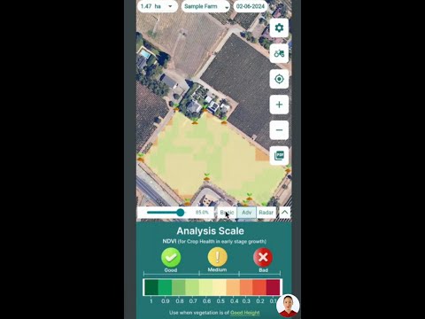
🌿 Advanced Analysis: Diving Deeper into Crop Health
For a more detailed assessment of crop health, particularly in the early stages of growth, the advanced option offers access to NDVI (Normalized Difference Vegetation Index) information. This powerful tool is especially useful for monitoring young plants up to 3 feet tall.
Understanding NDVI
NDVI uses a color-coded scale to identify areas where crop health is thriving or declining:
- Dark green to light green: Healthy regions
- Very light green to light orange: Medium health
- Dark orange to red: Poor health

For crops in their initial stages (just sown or 10-12 days old), users can adjust the settings to select a different color map for more detailed analysis of short vegetation. After selecting the appropriate color map, clicking “show on map” displays a detailed analysis scale with zones categorized as good, medium, and bad.
☁️ Radar Data: Overcoming Weather Challenges
One of the most innovative features of advanced agri-tech mobile satellite services is the ability to use radar data during periods of cloud cover and rain. This capability ensures that farmers can continue to monitor their crops even in less-than-ideal weather conditions.
Key Radar Indices
The radar option utilizes two primary indices:
- RVI (Radar Vegetation Index): Assesses crop health in cloudy weather using a scale similar to NDVI.
- RSM (Radar Soil Moisture): Provides information on irrigation status, also using a good, medium, and bad analysis scale.

These radar-based tools are invaluable for maintaining consistent crop monitoring regardless of atmospheric conditions, ensuring that farmers never miss critical information about their fields.
💧 Irrigation Indicators: Ensuring Optimal Water Management
Effective water management is crucial for sustainable agriculture, and agri-tech mobile satellite services offer several tools to help farmers optimize their irrigation practices. These indicators provide detailed insights into water content and soil moisture across plantations.
Key Irrigation Indices
- NDWI (Normalized Difference Water Index): Checks plantation water content
- NDMI (Normalized Difference Moisture Index): Indicates soil moisture levels
- Evapotranspiration: Shows where water is evaporating and transpiring quickly from soil and plants

Each of these indices uses a similar good, medium, and bad scale to help farmers quickly identify areas that may require attention. By leveraging these tools, farmers can make informed decisions about when and where to irrigate, potentially saving water and improving crop yields.
🛰️ Enhanced Satellite Imagery: A Clear View of Your Fields
In addition to analytical tools, agri-tech mobile satellite services often provide enhanced true color imagery of plantations. This feature offers a visual representation of the actual fields, helping farmers to understand crop presence and distribution.
- Green patches indicate plantation regions
- Orange patches suggest areas with less height or no plantation

This visual data complements the analytical tools, providing a comprehensive understanding of field conditions and crop distribution.
🌍 Additional Parameters for Comprehensive Farm Management
Advanced agri-tech mobile satellite services go beyond basic crop health and irrigation monitoring, offering additional parameters that provide a holistic view of farm conditions.
Soil Organic Carbon (SOC)
SOC checks locations where soil organic carbon is declining. This tool is particularly useful:
- Before sowing: To assess soil health
- After harvesting: To evaluate the impact of the previous crop
Low SOC indicates low nutrients, enabling targeted soil testing and nutrient replenishment strategies.
Digital Elevation Model (DEM)
DEM helps understand terrain variations, categorizing areas as high, medium, or low. This information is crucial for:
- Preventing water logging
- Identifying flood-prone areas during heavy rain or excessive irrigation
- Planning preemptive measures like drainage systems

By utilizing these additional parameters, farmers can make more informed decisions about soil management and field preparation, leading to improved crop health and yields.
👁️ Accessibility Features: Color-Blind Mode
In an effort to make agri-tech mobile satellite services accessible to all farmers, many apps include a color-blind mode. This feature uses black and white differentiation to simplify crop health and water stress assessment.
- Black areas indicate regions needing attention
- White areas represent healthy or well-irrigated zones

This thoughtful inclusion ensures that color-blind farmers can benefit from the same insights as their peers, promoting inclusive agricultural technology.
🤔 FAQ: Common Questions About Agri-Tech Mobile Satellite Services
Q: What is a WhatsApp satellite, and how does it relate to agri-tech?
A: While “WhatsApp satellite” isn’t a specific technology, it likely refers to the integration of satellite data with messaging platforms like WhatsApp. This could allow farmers to receive alerts and updates about their crops directly through familiar messaging apps.
Q: How accurate is satellite-based monitoring for agriculture?
A: Satellite-based monitoring can be highly accurate, often providing insights within a few meters of precision. However, accuracy can vary based on factors such as satellite resolution, weather conditions, and the specific parameters being measured.
Q: Can agri-tech mobile satellite services work offline?
A: While some features may be available offline, most agri-tech mobile satellite services require an internet connection to download the latest satellite data and provide up-to-date analysis.
Q: How often is satellite data updated in these apps?
A: The frequency of updates can vary depending on the service provider and the satellites used. Some services offer daily updates, while others may update every few days or weekly.
Q: Are these services suitable for small-scale farmers?
A: Yes, many agri-tech mobile satellite services are designed to be accessible and useful for farmers of all scales, from small family farms to large agricultural operations.
🌾 Conclusion: The Future of Farming with Agri-Tech Mobile Satellite Services
The integration of agri-tech mobile satellite services into modern farming practices represents a significant leap forward in agricultural technology. By providing farmers with real-time, detailed insights into crop health, irrigation needs, and field conditions, these tools are enabling more informed decision-making and more efficient resource management.
From basic analysis to advanced radar data, from comprehensive irrigation indicators to soil health assessments, agri-tech mobile satellite services offer a suite of powerful tools that can benefit farmers of all scales. As these technologies continue to evolve and become more accessible, we can expect to see even greater advancements in sustainable agriculture and food security worldwide.
For farmers looking to stay at the forefront of agricultural innovation, exploring and adopting these agri-tech mobile satellite services could be the key to unlocking new levels of productivity and sustainability in their operations. As we move forward, the synergy between traditional farming knowledge and cutting-edge technology will undoubtedly shape the future of agriculture, ensuring a more resilient and productive global food system.