Prescribed Burns in Carolina: 7 Powerful Ways to Reduce Wildfire Risk
“Over 1.2 million acres in the Carolinas are at high wildfire risk, threatening rare plant ecosystems and neighborhoods.”
The Urgent Need for Controlled Burning in Carolina
As stewards of our land, we face an escalating challenge: wildfire risk in coastal regions of the Carolinas. Our counties, especially Horry County near Myrtle Beach and Conway, are home to fire-adapted yet vulnerable ecosystems like the Carolina Bays, where rare plants and wildlife coexist with the threat of catastrophic wildfires. With a growing population, more neighborhoods abutting fire-prone lands, and mounting evidence from recent disasters, our commitment to responsible land management and prescribed burns in Carolina has never been more crucial.
This blog explores how prescribed burns—intentionally set, carefully managed fires—can dramatically reduce wildfire risk, protect precious wetlands, shield neighborhoods, and sustain rare plant ecosystems. Drawing on the Carolina Bays fire history and the lessons of recent blazes, we discuss the vital role of controlled burning for land management in our counties, outline seven powerful ways these practices work, and highlight innovative approaches and technologies, including those pioneered by Farmonaut, that support a safer and more resilient Carolina for all of us.


Understanding Wildfire Risk in Coastal Carolina Regions
Every year, the threat of uncontrolled fires looms large over our counties and communities, especially across fire-prone areas like Horry County, the Lewis Ocean Bay Heritage Preserve, and parts of Conway and Myrtle Beach. Our unique geography—home to the rare Carolina Bays, sandy soils, and a patchwork of wetlands and pine forests—creates conditions ripe for both plant diversity and fire disaster.
As population surges and development continues closer to fire-adapted ecosystems, the risk to homes, neighborhoods, wetlands, and rare plant habitats increases. The counties’ fire history is marked by major incidents: the 1976 wildfire that scorched 30,000 acres, and the 2009 Highway 31 fire that consumed 19,130 acres and devastated 76 homes. Today, over 1.2 million acres in the Carolinas are at high wildfire risk, putting both natural and human communities in jeopardy.
- Sandy, nutrient-poor soils lead to slow-growing but highly flammable pine forests.
- Dense, oily evergreens in the bays provide vast fuel for fires.
- Fire-dependent ecosystems need frequent, low-intensity burns to thrive—but drought and development disrupt this cycle.

Carolina Bays Fire History: Lessons from Past Wildfires
Our region’s Carolina Bays fire history is a stark reminder of the dangers posed by unchecked vegetation and insufficient land management. The organic soils of these bays not only sustain unique Venus flytraps and carnivorous plants but can also burn for weeks, fueling smoldering ground fires resistant to traditional suppression.
Major Wildfires in Recent Decades
- 1976: A neglected campfire ignites a blaze covering 30,000 acres near Conway.
- 2009: The Highway 31 wildfire burns through 19,130 acres between Conway and Myrtle Beach, destroying 76 homes and damaging nearly 100 others.
- 2023-2024: The latest fire scorched over 2,000 acres within and near county-owned mitigation banks, some of which had never been burned since their acquisition.
Continuous development near fire-prone ecosystems, coupled with drought conditions and the accumulation of fuel, ensure that these fire events will not be rare going forward—unless we adopt more aggressive and strategic approaches to land management.

The Role of Prescribed Burns in Carolina
Prescribed burns in Carolina are not just a tradition—they are an essential tool for responsible, science-based fire prevention plans for county land. When implemented with rigorous oversight and coordination with federal and state agencies, these scheduled, planned fires eliminate dangerous overgrowth, rejuvenate rare plant habitats, and create “speed bumps” that limit wildfire spread.
Why are prescribed burns needed?
- They reduce the built-up fuel loads (pine straw, leaf litter, dense vegetation) that drive uncontrollable wildfires.
- They mimic the natural fire cycles upon which many Carolina Bay ecosystems and species (like the Venus flytrap) depend.
- They provide ecological benefits—clearing space for rare plants and maintaining open, healthy wetlands.
- They create or reinforce strategic fire breaks and defense zones to safeguard neighborhoods and infrastructure from disaster.
Recent tragedy has shown us that delays in prescribed burning can make even county-owned lands ticking timebombs. As wildfires grow longer and harder to contain, we must prioritize and streamline the approval and implementation of controlled burning for land management in every vulnerable region.
7 Powerful Ways Prescribed Burns Reduce Wildfire Risk
“Prescribed burns can reduce wildfire risk by up to 80% in Carolina counties, safeguarding wetlands and local communities.”
-
Removing Hazardous Fuel Loads
By eliminating pine straw, dead wood, and dense undergrowth, prescribed burns prevent dangerous “fuel ladders” that let wildfires leap into tree canopies and spread fast. This controls both surface and crown fires on critical county property and wildland–urban interfaces.
-
Maintaining Healthy, Fire-Dependent Ecosystems
Many Carolina Bays plant species—including rare wildflowers and carnivorous plants—depend on periodic fire to open up sunlight, remove competitors, and trigger germination. Controlled burns preserve this natural cycle, support restoring rare plant ecosystems, and contribute to a diverse landscape.
-
Protecting Wetlands & Water Quality
Burning at the right intervals and intensities maintains open wetlands, prevents shrub encroachment, and sustains ecological processes that filter and slow stormwater. It’s essential for wetlands mitigation projects and for the health of sensitive areas near Lewis Ocean Bay Heritage Preserve.
-
Creating Effective Fire Breaks & Defense Zones
Prescribed burns help create or strengthen lines where fuel is sparse (fire breaks). These act as “speed bumps” to slow advancing fires, increase fire containment, and buy time for crews to protect homes and neighborhoods—as demonstrated during the March 2024 Horry County fire.
-
Reducing Smoke & Air Quality Risks from Mega-Fires
By keeping fuel loads low, controlled burns reduce the chance of catastrophic fires that can generate intense, persistent smoke and smoldering soils. This benefits public health and cuts down on costly, disruptive evacuations.
-
Safeguarding Neighborhoods Amid Ongoing Urban Expansion
With rapid growth around Myrtle Beach, Conway, and the Carolina Forest area, scheduled burning is vital for keeping new developments safe—especially where the wildland meets the urban-wildfire interface. It helps reduce risk for property values and community well-being.
-
Supporting Sustainable Land Management & Compliance
Prescribed burns are recognized by state commissions, federal agencies, and conservation groups as best practice for both wildfire prevention and ecological stewardship. They are a requirement in successful mitigation projects and land management in wildfire-prone areas.

Comparative Impact Table: Wildfire Risk Reduction in Carolina Counties
To see the real-world value of prescribed burns in Carolina, see how outcomes compare before and after applying these science-backed methods. This table summarizes estimates for select counties—demonstrating the tremendous benefit for wetlands, neighborhoods, and rare plant ecosystems.
| County Name | Estimated Wildfire Incidents/Year (Before Prescribed Burns) |
Estimated Wildfire Incidents/Year (After Prescribed Burns) |
Wetlands Protected (acres) |
Neighborhoods at Reduced Risk | Presence of Rare Plant Ecosystems |
|---|---|---|---|---|---|
| Horry | 9 | 2 | 3,750 | 12 | Yes |
| Brunswick | 7 | 1 | 2,100 | 8 | Yes |
| Georgetown | 6 | 2 | 1,900 | 7 | Yes |
| Columbus | 5 | 1 | 1,550 | 5 | No |
| Berkeley | 8 | 3 | 2,350 | 10 | Yes |
We can clearly see that prescribed burning is not just an environmental strategy—it’s a proven investment in public safety and community resilience.
Land Management in Wildfire-Prone Areas: Strategies & Challenges
Employing fire containment and mitigation strategies in wildfire-prone Carolina areas requires consistent vision, expert coordination, and respect for the complex relationship between development, nature, and the realities of fire risk.
The Challenges
- Approval Delays: Large-scale mitigation bank projects require extensive evaluation by the US Army Corps of Engineers, and cooperation with federal and state agencies such as the South Carolina DNR, which can extend timelines for prescribed burns.
- Urban Encroachment & Policy: Proximity to neighborhoods and proposals like the Conway Medical Center hospital can slow or restrict burning schedules, despite expert advice that controlled burns are vital for ecosystem and community safety.
- Drought & Weather Conditions: Lingering drought increases fire risk—but can also make burning too dangerous, requiring skilled timing and flexibility.
- Changing Ecosystem Needs: As plant and wildlife populations shift, burning protocols must adapt to ensure both conservation and hazard reduction are balanced.
In the recent wildfire, cutting initial fire breaks in anticipation of prescribed burns helped slow the fire’s spread. This demonstrated the importance of planned proactive strategies.

Restoring Rare Plant Ecosystems and Wetlands
Our Carolina Bays are ecological gems—supporting not only carnivorous plants but also rare orchids, pitcher plants, and unique wetland communities found nowhere else in North America. Without regular fire, these sites become choked by overgrowth, shading out rare species and increasing the likelihood of destructive fires.
How Prescribed Burns Enhance Biodiversity
- Opening the Canopy: Low-intensity fire removes shrubs and small trees, letting sunlight reach sensitive plants.
- Boosting Germination: Some rare plants require the heat or chemical signals from smoke to sprout.
- Maintaining Wetland Hydrology: Regular burning prevents succession from wet meadow to impenetrable forest.
- Controlling Invasives: Fire favors many native species while holding back invasive competitors.
When we implement scheduled burning as part of our wetlands mitigation projects, we do more than safeguard neighborhoods—we invest in long-term conservation.
Smart Tools & Innovative Technologies for Fire Management
The complexities of fire risk, ecosystem needs, and modern development require data-driven, accessible solutions. Today, remote sensing technologies such as satellite-based monitoring and AI-powered analytics empower county officials, forestry crews, and conservationists to:
- Map fuel loads and vulnerable areas using up-to-date maps and multispectral imagery
- Track the effectiveness and timing of prescribed burns by comparing vegetation indices before and after burning
- Forecast fire risk with weather and soil moisture models, improving safety and efficiency
- Plan and monitor large-scale farm/land management projects
These smart tools are essential for scaling up fire prevention plans, overseeing compliance with federal and state requirements, and ultimately for restoring rare plant ecosystems and safeguarding wetlands.
Farmonaut’s API and Developer Docs make it easy for agencies, organizations, and researchers to integrate near real-time satellite data and weather analytics into their own fire management systems.
Additionally, Farmonaut’s Product Traceability solutions enable transparent reporting on land management practices, benefitting government compliance and public trust.
How Farmonaut’s Satellite-Based Systems Support Land and Fire Management
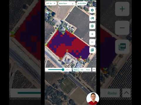
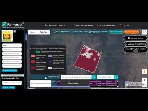
As a leader in affordable precision agriculture, Farmonaut provides state-of-the-art satellite-based solutions for farm and land management—which are easily adaptable for fire risk monitoring, prescribed burn planning, and ecosystem restoration across Carolina counties.
Key Features and Benefits:
- Satellite-Based Crop and Vegetation Monitoring: Track changes and health across vast landscapes, helping pinpoint zones with excess fuel, dry soils, or urgent burning needs.
- AI-Powered Planning: The Jeevn AI Advisory System synthesizes weather, soil, and satellite data to help land managers decide when, where, and how to burn safely—improving scheduling, compliance, and results.
- Carbon Footprint Tracking: Analyze and reduce emissions from land management operations (including controlled burns), aiming for sustainable land stewardship.
- Fleet & Resource Management: Monitor and coordinate equipment, burned areas, and fire breaks for efficient operations and timely response during burning season.
- Blockchain Traceability: Securely document burning events, restoration efforts, and compliance for both regulatory agencies and public reporting.
Accessible anytime via Android, iOS, web app, or API, Farmonaut lets county officials, conservationists, and agencies harness the best in modern technology for natural resource protection.
Farmonaut Subscription Plans
Farmonaut operates on a flexible, subscription-based model—offering scalable services for individual landowners, county officials, government agencies, and conservation organizations involved in wildfire risk reduction, wetland mitigation projects, or large-scale ecosystem stewardship.
Choose the package that best suits your acreage, monitoring needs, and management objectives—all accessible via mobile or browser-based app.
Frequently Asked Questions (FAQ)
What are prescribed burns and why are they necessary in Carolina counties?
Prescribed burns in Carolina are intentionally set, carefully managed fires designed to mimic the natural fire cycles typical of our region’s ecosystems. They reduce hazardous fuel loads, protect rare plant communities, maintain healthy wetlands, and significantly decrease the risk of catastrophic wildfires that can threaten neighborhoods and public health.
How do prescribed burns reduce wildfire risk?
By eliminating overgrown vegetation, pine straw, and dead wood, controlled burns create environments where wildfire cannot easily spread or become severe. Studies show they can reduce wildfire risk by up to 80% and are one of the best strategies for land management in wildfire-prone areas.
Do prescribed burns threaten rare plant species?
No—in fact, many rare plants (such as Venus flytraps and certain orchids) depend on periodic fire to thrive. Prescribed burns open up sunlight, clear space for seed germination, and support native biodiversity, provided they are planned and managed responsively.
Who oversees and approves controlled burning in Carolina counties?
Prescribed burns require rigorous coordination with local county officials, the South Carolina Forestry Commission, the Department of Natural Resources (DNR), and, for large projects, federal approval from the US Army Corps of Engineers. This process ensures burns are safe, effective, and considerate of public health and conservation needs.
How can technology improve prescribed burn planning and fire management?
Technologies like those offered by Farmonaut allow for up-to-date mapping of fuels and vegetation, AI-driven decision support on when and where to burn, efficient resource (fleet) management, and transparent reporting via blockchain. These innovations lead to safer, smarter land management that serves both people and nature.
Can I use Farmonaut to monitor land outside agriculture?
Yes! Farmonaut’s tools support not only farmers but also forestry officials, conservationists, and public agencies involved in wildfire risk reduction, wetlands restoration, and ecosystem stewardship across all rural and peri-urban landscapes.
Conclusion: Creating a Resilient, Sustainable Carolina
As our counties grow and change, so do our responsibilities. Armed with the lessons of Carolina Bays fire history and the proven effectiveness of prescribed burns in Carolina, we are called to act—protecting both neighborhoods and the rich tapestry of wetlands, rare plants, and wildfire-adapted ecosystems at the heart of our region.
With unwavering commitment to science-based strategy, diligent coordination between officials, agencies, and conservation groups, and support from smart technologies like Farmonaut’s advanced farm and land management solutions, we can dramatically reduce wildfire risk, heal our natural land, and build a future where both people and the environment thrive—together.
Ready to empower your wildfire risk management or ecosystem restoration project?
Start leveraging smart, affordable solutions with Farmonaut today.