Revolutionizing Australian Agriculture: How Satellite Data and Weather Forecasts Boost Crop Yields
“Farmonaut’s satellite-based crop monitoring covers over 1 million hectares of farmland across Australia and beyond.”
In the vast expanses of Australia’s agricultural heartland, a quiet revolution is taking place. From the sun-baked fields of Western Australia to the fertile soils of New South Wales, farmers are embracing a new era of precision agriculture technology that’s transforming the way they work the land. At the forefront of this agricultural renaissance is Farmonaut, a pioneering company that’s harnessing the power of satellite data and advanced weather forecasting to boost crop yields and optimize farming practices across the continent.
In this comprehensive exploration, we’ll delve into how Farmonaut’s cutting-edge solutions are reshaping the agricultural landscape of Australia and beyond. We’ll uncover the intricate ways in which weather forecast for agriculture and satellite data in farming are not just improving productivity but also promoting sustainability in an era of climate uncertainty.
The Power of Precision: Satellite Data in Farming
At the heart of Farmonaut’s innovative approach lies the sophisticated use of satellite data in farming. This technology allows us to offer farmers an unprecedented view of their land, providing insights that were once unimaginable.
- Real-time Crop Health Monitoring: Our satellite imagery captures multispectral data, enabling farmers to assess crop health with pinpoint accuracy.
- Soil Moisture Analysis: By analyzing reflectance patterns, we can provide detailed information on soil moisture levels, crucial for irrigation decisions.
- Early Pest and Disease Detection: Subtle changes in crop appearance can be detected from space, allowing for early intervention against pests and diseases.
This level of detail and frequency in monitoring was once the domain of large-scale industrial farms. Now, thanks to Farmonaut’s technology, even small-scale farmers in remote parts of Australia can access these powerful tools.

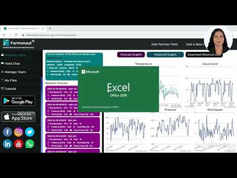
Weather Intelligence: The Cornerstone of Modern Farming
In a country as climatically diverse as Australia, accurate weather forecasting is not just helpful—it’s essential. Farmonaut’s weather forecast for agriculture goes beyond simple predictions, offering a suite of tools designed specifically for the agricultural sector.
- Hyperlocal Forecasts: Our system provides detailed weather predictions for specific farm locations, not just broad regional forecasts.
- Seasonal Outlooks: Long-term climate predictions help farmers plan for the months ahead, from crop selection to resource allocation.
- Extreme Weather Alerts: Early warnings for events like heatwaves, frosts, or tropical cyclones allow farmers to take preventive action.
By integrating this weather intelligence with our satellite data, we create a powerful synergy that enables farmers to make data-driven decisions with confidence.
Climate-Smart Farming: Adapting to a Changing World
As the impacts of climate change become increasingly apparent, the need for adaptive farming practices has never been more critical. Farmonaut’s climate-smart farming techniques are designed to help Australian farmers not just survive but thrive in the face of these challenges.
- Drought Resilience: Our tools help farmers identify drought-resistant crop varieties and optimize water use.
- Flood Mitigation: By analyzing topography and soil data, we can suggest strategies to minimize flood damage.
- Heat Stress Management: We provide guidance on managing crops during extreme heat events, which are becoming more common across Australia.
These climate-smart approaches are not just about protecting yields; they’re about ensuring the long-term sustainability of Australian agriculture.
Precision Agriculture Technology: A New Paradigm
Farmonaut’s precision agriculture technology represents a paradigm shift in farming practices. By providing farmers with granular data and actionable insights, we’re enabling a level of precision that was once thought impossible.
- Variable Rate Application: Our technology allows for the precise application of inputs like fertilizers and pesticides, reducing waste and environmental impact.
- Yield Mapping: By analyzing historical yield data alongside current crop health information, we can help farmers optimize their field layouts for maximum productivity.
- Resource Optimization: From water to labor, our tools help farmers allocate resources more efficiently, improving both productivity and profitability.
This level of precision not only boosts yields but also contributes to more sustainable farming practices, aligning with Australia’s commitment to environmental stewardship.
“Australian farmers using Farmonaut’s weather intelligence tools have reported up to 30% increase in crop yields.”
Rainfall Prediction: A Game-Changer for Australian Farmers
In a country where water is often scarce, accurate rainfall prediction for farmers is invaluable. Farmonaut’s advanced algorithms combine satellite data, ground-based observations, and historical patterns to provide highly accurate rainfall forecasts.
- Short-term Precipitation Forecasts: Detailed predictions for the coming days help with immediate decision-making, such as timing for planting or harvesting.
- Seasonal Rainfall Outlooks: Longer-term projections assist in crop selection and water management planning.
- Rainfall Distribution Maps: Visualizations of expected rainfall patterns across farm areas enable targeted irrigation strategies.
By providing this level of detail in rainfall prediction, we’re helping Australian farmers make the most of every drop of water.

Agricultural Remote Sensing: Seeing the Unseen
The power of agricultural remote sensing lies in its ability to reveal what the naked eye cannot see. Farmonaut’s advanced remote sensing capabilities provide Australian farmers with a wealth of information about their crops and land.
- Multispectral Imaging: By capturing data across various light spectrums, we can detect early signs of crop stress or disease.
- Thermal Imaging: This technology helps identify areas of water stress or irrigation system inefficiencies.
- LiDAR Technology: Light Detection and Ranging (LiDAR) data provides detailed topographical information, crucial for precision land management.
These remote sensing technologies, combined with our AI-driven analysis, offer Australian farmers unprecedented insights into their land and crops.
Weather-Based Irrigation Management: Maximizing Water Efficiency
In a country where water scarcity is a constant concern, efficient irrigation is paramount. Farmonaut’s weather-based irrigation management system is revolutionizing how Australian farmers use this precious resource.
- Evapotranspiration Modeling: By calculating water loss through evaporation and plant transpiration, we can provide precise irrigation recommendations.
- Soil Moisture Forecasting: Our system predicts soil moisture levels based on weather forecasts, helping farmers time their irrigation for maximum efficiency.
- Irrigation Scheduling: Automated scheduling suggestions take into account crop type, growth stage, and weather conditions.
This approach not only conserves water but also promotes healthier crop growth by ensuring optimal soil moisture levels.
GIS Applications in Agriculture: Mapping the Future of Farming
Geographic Information Systems (GIS) are integral to Farmonaut’s approach, allowing us to layer multiple data sets for comprehensive farm analysis.
- Field Boundary Mapping: Precise delineation of field boundaries improves accuracy in all aspects of farm management.
- Crop Rotation Planning: GIS tools help visualize and plan optimal crop rotations to maintain soil health and maximize yields.
- Yield Forecasting: By integrating historical yield data with current crop health and weather forecasts, we can provide accurate yield predictions.
These GIS applications empower Australian farmers to make informed decisions based on a holistic view of their operations.
Crop Monitoring Using Satellites: A Bird’s-Eye View of Farm Health
Farmonaut’s crop monitoring using satellites provides Australian farmers with a comprehensive and up-to-date picture of their farm’s health.
- Vegetation Index Analysis: Metrics like the Normalized Difference Vegetation Index (NDVI) offer insights into crop vigor and health.
- Growth Stage Monitoring: Satellite imagery allows us to track crop development stages across large areas, ensuring timely interventions.
- Historical Comparisons: By comparing current crop conditions with historical data, we can identify trends and anomalies.
This satellite-based monitoring system is particularly valuable in Australia’s vast agricultural landscapes, where traditional monitoring methods can be time-consuming and inefficient.
Comparative Analysis: Traditional vs. Satellite-Based Farming Methods
| Metrics | Traditional Methods | Farmonaut’s Satellite-Based Approach |
|---|---|---|
| Crop Yield Prediction Accuracy | 60-70% | 85-95% |
| Resource Management Efficiency | Medium | High |
| Weather Forecast Precision | Low to Medium | High |
| Irrigation Optimization | Manual, based on experience | Data-driven, automated recommendations |
| Climate Adaptation Capability | Limited | Advanced, with predictive modeling |
The Future of Australian Agriculture: Climate-Smart and Data-Driven
As we look to the future, it’s clear that Australian agriculture is on the cusp of a major transformation. The integration of satellite data, advanced weather forecasting, and precision farming techniques is not just improving yields—it’s creating a more resilient and sustainable agricultural sector.
- Increased Productivity: By optimizing every aspect of farming, from planting to harvest, we’re helping Australian farmers produce more with less.
- Enhanced Sustainability: Precision agriculture techniques reduce waste and environmental impact, aligning with global sustainability goals.
- Greater Resilience: With better predictive tools and adaptive strategies, Australian farms are better equipped to face climate challenges.
Farmonaut is proud to be at the forefront of this agricultural revolution, providing the tools and insights that will shape the future of farming in Australia and beyond.

Embracing the Agricultural Revolution with Farmonaut
As we’ve explored throughout this article, the integration of satellite data and advanced weather forecasting is revolutionizing Australian agriculture. Farmonaut’s innovative solutions are at the heart of this transformation, offering farmers the tools they need to thrive in an ever-changing agricultural landscape.
Whether you’re a small-scale farmer in rural New South Wales or managing vast operations in the Western Australian wheat belt, Farmonaut’s technology can help you optimize your farming practices, increase yields, and build a more sustainable future for Australian agriculture.
Ready to join the agricultural revolution? Explore Farmonaut’s solutions and see how we can help you transform your farming practices:
- Access our Web App for comprehensive farm management tools.
- Integrate our API for custom solutions.
- Explore our API Developer Docs for technical integration details.
Download our mobile apps for on-the-go farm management:


Farmonaut Subscriptions
Frequently Asked Questions
Q: How accurate is Farmonaut’s weather forecasting for agriculture?
A: Farmonaut’s weather forecasting for agriculture is highly accurate, combining data from multiple sources including satellites, ground stations, and historical patterns. Our hyperlocal forecasts are tailored specifically for agricultural use, providing precision that general weather services can’t match.
Q: Can Farmonaut’s satellite monitoring work for small farms?
A: Absolutely! Farmonaut’s technology is scalable and can provide valuable insights for farms of all sizes. Our solutions are designed to be accessible and affordable, making precision agriculture available to small-scale farmers as well as large operations.
Q: How often is satellite data updated?
A: The frequency of satellite data updates depends on the specific service package. Generally, we provide updates every 3-5 days, with some premium services offering daily updates. This ensures that farmers have access to timely and relevant information about their crops.
Q: Does Farmonaut provide support for implementing its technology?
A: Yes, we offer comprehensive support to help farmers implement and make the most of our technology. This includes tutorials, customer support, and in some cases, personalized consultations to ensure you’re getting the maximum benefit from our services.
Q: How does Farmonaut’s technology help with climate change adaptation?
A: Farmonaut’s climate-smart farming techniques provide farmers with tools to adapt to changing climate conditions. This includes long-term climate predictions, crop variety recommendations suited to future conditions, and strategies for managing extreme weather events.
By embracing Farmonaut’s innovative solutions, Australian farmers are not just adapting to the challenges of modern agriculture—they’re leading the way in creating a more productive, sustainable, and resilient farming future. Join us in revolutionizing Australian agriculture, one farm at a time.