Revolutionizing Czech Agriculture: How Satellite Crop Monitoring Solves Field Problems Before They Escalate

“Satellite crop monitoring can detect up to 90% of field problems before they become visible to the naked eye.”
In the heart of Central Europe, Czech agriculture is undergoing a remarkable transformation. As we venture into the era of precision agriculture technology, the integration of satellite crop monitoring and field scouting techniques is revolutionizing how farmers approach their daily challenges. This blog post delves into the innovative solutions that are changing the face of farming in the Czech Republic, with a particular focus on how these technologies are enabling farmers to solve crop problems before they escalate.
The Evolution of Field Management in Czech Agriculture
Traditionally, Czech farmers relied heavily on manual field scouting to assess crop health and identify potential issues. While this method has served the agricultural community for generations, it comes with inherent limitations in terms of efficiency, coverage, and early problem detection. Enter satellite crop monitoring – a game-changing approach that is transforming how we view and manage our fields.
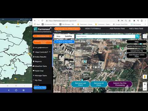
At Farmonaut, we’re at the forefront of this agricultural revolution, providing cutting-edge satellite-based farm management solutions that are accessible via Android, iOS, web browsers, and API. Our mission is to democratize precision agriculture, making it affordable and available to farmers across the Czech Republic and beyond.
The Power of Satellite Crop Monitoring in Problem-Solving
Satellite crop monitoring is not just about pretty pictures from space; it’s a powerful tool that provides farmers with actionable insights. Here’s how it’s solving field problems before they become critical:
- Early Pest Detection: By analyzing multispectral imagery, we can identify subtle changes in crop health that may indicate pest infestations long before they’re visible to the naked eye.
- Soil Moisture Analysis: Satellite data allows us to map soil moisture levels across entire fields, enabling precise irrigation management and preventing water stress.
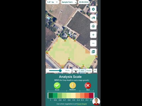
- Crop Health Assessment: Regular monitoring of vegetation indices like NDVI (Normalized Difference Vegetation Index) helps in tracking crop health throughout the growing season.
- Yield Optimization: By identifying areas of underperformance early, farmers can take corrective actions to maximize potential yield.
Try Farmonaut’s Web App for advanced satellite crop monitoring
Integrating Field Scouting with Satellite Technology
While satellite crop monitoring offers unprecedented insights, it doesn’t render traditional field scouting obsolete. Instead, it enhances it. Here’s how Czech farmers are combining these approaches for optimal results:
- Targeted Scouting: Satellite data identifies problem areas, allowing farmers to focus their on-ground efforts where they’re most needed.
- Geotagging Issues: Using mobile apps, farmers can geotag specific problems they encounter during field walks, creating a comprehensive map of field issues.
- Data Validation: On-ground observations help validate and refine satellite data interpretations, improving the accuracy of future analyses.
- Timely Interventions: The combination of satellite insights and field observations enables farmers to make quick, informed decisions on pest control, fertilization, and other critical actions.
“Farmers using precision agriculture techniques can reduce water usage by up to 30% through accurate soil moisture analysis.”
Practical Applications Across the Growing Season
Let’s explore how satellite crop monitoring and field scouting work together throughout the agricultural cycle in the Czech Republic:
Seeding and Planting
- Utilize historical satellite data to optimize planting patterns
- Assess soil readiness for planting using moisture maps
- Plan field trials based on previous season’s performance data
Early Growth Stage
- Monitor crop emergence and identify areas requiring replanting
- Detect early signs of pest infestations or diseases
- Optimize fertilization strategies based on crop vigor maps
Mid-Season Management
- Track crop development and compare with expected growth curves
- Identify areas of stress or underperformance for targeted interventions
- Adjust irrigation schedules based on real-time soil moisture data
Pre-Harvest Assessment
- Estimate yields and plan harvest logistics
- Identify areas that may require early or delayed harvesting
- Assess overall crop health to inform post-harvest field management decisions
Explore Farmonaut’s API for custom satellite data integration

Crop-Specific Applications in Czech Agriculture
The Czech Republic is known for its diverse agricultural landscape. Let’s look at how satellite crop monitoring is benefiting some key crops:
Potato Cultivation
Potato farmers in regions like Vysočina are using satellite data to:
- Monitor soil moisture to prevent tuber diseases
- Detect early signs of late blight for timely fungicide applications
- Optimize irrigation to ensure consistent tuber size and quality
Barley Production
Barley growers, especially in South Moravia, leverage satellite monitoring to:
- Track nitrogen uptake for precise fertilizer management
- Identify areas prone to lodging for targeted growth regulator applications
- Monitor crop maturity for optimal harvest timing
Rapeseed Cultivation
Rapeseed farmers across the Czech Republic use satellite data for:
- Assessing winter survival rates in early spring
- Monitoring flowering progression for precise pest control
- Optimizing desiccation timing based on crop maturity maps
Access Farmonaut’s API Developer Docs for advanced integration
The Economic Impact of Precision Agriculture in the Czech Republic
The adoption of satellite crop monitoring and precision agriculture technologies is having a significant economic impact on Czech farming:
- Cost Reduction: By optimizing inputs like water, fertilizers, and pesticides, farmers are seeing substantial reductions in operational costs.
- Yield Increases: Early problem detection and timely interventions are leading to notable increases in crop yields across various commodities.
- Labor Efficiency: Targeted scouting and automated monitoring reduce the need for extensive manual field inspections, improving labor efficiency.
- Environmental Benefits: Precision application of inputs not only saves money but also reduces the environmental footprint of farming operations.

Overcoming Challenges in Adoption
While the benefits of satellite crop monitoring are clear, some challenges remain in its widespread adoption across the Czech Republic:
- Technical Know-How: We’re addressing this by providing user-friendly interfaces and comprehensive training resources.
- Initial Investment: Farmonaut offers flexible pricing models to make the technology accessible to farms of all sizes.
- Data Interpretation: Our AI-powered advisory system, Jeevn AI, helps farmers make sense of complex satellite data.
- Integration with Existing Practices: We work closely with farmers to ensure smooth integration with their current farming methods.


The Future of Czech Agriculture: A Data-Driven Approach
As we look to the future, the integration of satellite crop monitoring and field scouting techniques is set to become the norm in Czech agriculture. This data-driven approach will enable:
- Predictive Analytics: Using historical and real-time data to forecast potential issues before they occur.
- Automated Decision Support: AI-powered systems providing tailored recommendations for each field and crop.
- Precision Resource Management: Micro-level control over inputs, leading to more sustainable and efficient farming practices.
- Enhanced Traceability: From farm to table, satellite data will play a crucial role in ensuring food safety and quality.

Comparative Analysis: Traditional vs. Satellite-Enabled Farming
| Aspect | Traditional Field Scouting | Satellite Crop Monitoring |
|---|---|---|
| Time Efficiency | Time-consuming, manual process | Rapid, automated data collection |
| Coverage Area | Limited to physically accessible areas | Entire field coverage |
| Early Problem Detection | Often detects issues after visible symptoms appear | Can detect issues before visible symptoms |
| Cost-Effectiveness | Labor-intensive and costly for large areas | Scalable and cost-effective for any field size |
| Data Accuracy | Subjective, varies with scout’s experience | Objective, consistent data collection |
| Frequency of Monitoring | Limited by available labor and time | Regular monitoring (every 3-5 days typically) |
| Soil Moisture Analysis | Spot checks, limited depth analysis | Comprehensive field-wide moisture mapping |
| Pest Detection Capability | Visual inspection, may miss early stages | Can detect stress patterns indicative of pests |
| Crop Health Assessment | Visual assessment, potentially inconsistent | Quantitative health indices (e.g., NDVI) |
| Integration with Precision Agriculture | Limited integration capabilities | Seamless integration with other precision ag tools |
Conclusion: Embracing the Future of Czech Agriculture
The integration of satellite crop monitoring and field scouting techniques is not just a technological upgrade; it’s a paradigm shift in how we approach agriculture in the Czech Republic. By embracing these innovations, Czech farmers are positioning themselves at the forefront of modern agriculture, ready to face the challenges of feeding a growing population while maintaining environmental sustainability.
At Farmonaut, we’re committed to supporting this transition, providing the tools and expertise necessary to make precision agriculture accessible to all. From our user-friendly mobile apps to our comprehensive API solutions, we’re here to ensure that every Czech farmer can harness the power of satellite technology to solve field problems before they escalate.
As we move forward, the synergy between traditional farming wisdom and cutting-edge technology will undoubtedly shape the future of Czech agriculture. It’s an exciting time to be part of this agricultural revolution, and we invite you to join us in cultivating a smarter, more sustainable future for farming in the Czech Republic and beyond.
FAQ: Satellite Crop Monitoring in Czech Agriculture
- Q: How accurate is satellite crop monitoring compared to traditional field scouting?
A: Satellite crop monitoring can be highly accurate, often detecting issues before they’re visible to the naked eye. However, it’s most effective when used in conjunction with traditional scouting for ground-truthing and detailed observations. - Q: Is satellite monitoring suitable for small farms in the Czech Republic?
A: Yes, Farmonaut offers scalable solutions suitable for farms of all sizes. Our technology can be particularly beneficial for small farms by optimizing resource use and improving decision-making. - Q: How often are satellite images updated?
A: Typically, we provide updates every 3-5 days, depending on the satellite coverage and weather conditions. This frequency allows for timely detection of changes in crop health and field conditions. - Q: Can satellite monitoring detect specific pests or diseases?
A: While satellites can’t directly identify specific pests or diseases, they can detect stress patterns in crops that are indicative of various issues. This information guides farmers on where to focus their on-ground inspections. - Q: How does weather affect satellite monitoring?
A: Cloud cover can impact the quality of optical satellite imagery. However, we use multiple satellite sources and advanced processing techniques to minimize these effects and ensure consistent data availability. - Q: Is special equipment needed to use satellite crop monitoring services?
A: No special equipment is required. Farmers can access Farmonaut’s services through our web application, mobile apps, or API, using their existing devices such as smartphones, tablets, or computers. - Q: How does satellite monitoring help with irrigation management?
A: Satellite-based soil moisture analysis provides detailed maps of moisture levels across fields. This information helps farmers optimize irrigation schedules, applying water only where and when it’s needed. - Q: Can satellite monitoring help with crop insurance claims?
A: Yes, satellite data can provide objective evidence of crop conditions, which can be valuable for supporting insurance claims in cases of crop damage or loss. - Q: How does Farmonaut ensure data privacy and security?
A: We take data privacy seriously, employing industry-standard encryption and security measures to protect all user data. Our systems comply with relevant data protection regulations. - Q: Is training provided on how to interpret satellite data?
A: Yes, Farmonaut offers comprehensive training resources, including tutorials, webinars, and customer support to help farmers effectively interpret and utilize satellite data for their operations.