Revolutionize Farming with Farmonaut: Harnessing Satellite Imagery for Precision Crop Monitoring and Smart Agriculture
“Farmonaut’s satellite imagery can analyze crop health using NDVI and other vegetation indices across thousands of acres in minutes.”
In the ever-evolving landscape of agriculture, we at Farmonaut are at the forefront of a technological revolution that’s transforming the way we approach farming. Our cutting-edge satellite imagery and precision farming technologies are paving the way for a new era in agriculture, one where data-driven decisions and smart farming solutions are the norm rather than the exception.
In this comprehensive blog post, we’ll explore how Farmonaut is harnessing the power of satellite imagery for precision crop monitoring and smart agriculture. We’ll delve into the world of remote sensing in agriculture, showcasing our advanced crop monitoring tools that leverage NDVI (Normalized Difference Vegetation Index) and other vegetation indices. You’ll learn how our digital agriculture platforms are changing the game for farmers worldwide, providing crucial insights into crop performance and empowering them to optimize resource management and boost productivity.
So, whether you’re a smallholder farmer, an agribusiness manager, or simply curious about the future of farming, join us as we uncover the potential of satellite data in modern farming practices and see how this innovative technology is shaping the future of sustainable agriculture.
The Power of Satellite Imagery in Agriculture
Satellite imagery has revolutionized many industries, but its impact on agriculture has been particularly profound. At Farmonaut, we’ve harnessed this technology to provide farmers with unprecedented insights into their crops and land.
- Real-time monitoring: Our satellite-based crop monitoring system allows farmers to keep a constant eye on their fields without setting foot in them.
- Vast coverage: Satellite imagery can cover vast areas quickly, making it ideal for large-scale farming operations.
- Frequent updates: We provide regular updates, allowing farmers to track changes in their crops over time.
- Multispectral analysis: Our technology goes beyond what the human eye can see, using various spectral bands to detect issues invisible to the naked eye.
By leveraging satellite imagery, we’re able to offer a range of vegetation indices that provide crucial information about crop health and soil conditions.

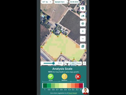
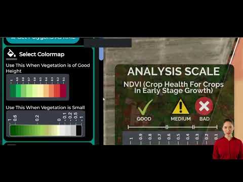
Understanding Vegetation Indices
Vegetation indices are mathematical combinations of different spectral bands that highlight specific properties of vegetation. At Farmonaut, we use a variety of these indices to provide comprehensive insights into crop health and soil conditions:
- NDVI (Normalized Difference Vegetation Index): This is perhaps the most well-known index, used to assess plant health and density.
- EVI (Enhanced Vegetation Index): An optimized version of NDVI that’s less sensitive to atmospheric conditions and soil background.
- NDWI (Normalized Difference Water Index): Used to monitor changes in water content of leaves and soil moisture.
- NRI (Normalized Reflectance Index): Helps in assessing leaf pigment content and overall plant stress.
- DSWI (Disease-Water Stress Index): Useful for detecting plant diseases and water stress.
These indices allow us to create detailed maps and statistics that give farmers a comprehensive view of their crop’s health and potential issues.
Precision Farming with Farmonaut
Precision farming is all about making informed decisions based on accurate data. At Farmonaut, we provide the tools and insights needed to make this a reality for farmers of all sizes.
- Custom field mapping: Our platform allows farmers to create detailed polygon maps of their fields.
- Historical data analysis: We provide access to historical satellite imagery, allowing farmers to track changes over time and make informed decisions about crop rotation and management practices.
- Weather forecasting: Our integrated weather forecasting tools help farmers plan their activities and anticipate potential issues.
- Crop calendars: We offer customizable crop calendars to help farmers stay on top of key dates and growth stages.
By combining these features with our advanced satellite imagery analysis, we’re able to provide a comprehensive precision farming solution that’s both powerful and user-friendly.
Smart Farming Solutions
Smart farming goes beyond just collecting data – it’s about using that data to make intelligent decisions. Our platform offers a range of smart farming solutions:
- AI-powered insights: Our advanced algorithms analyze satellite data to provide actionable insights and recommendations.
- Automated alerts: Farmers receive notifications about potential issues like pest infestations or nutrient deficiencies.
- Resource optimization: Our tools help farmers optimize their use of water, fertilizers, and other resources.
- Yield prediction: By analyzing historical data and current conditions, we can provide accurate yield predictions.
These smart farming solutions are designed to help farmers increase their productivity while reducing waste and environmental impact.
“Farmers using Farmonaut’s precision agriculture tools can access historical crop data spanning multiple growing seasons for informed decision-making.”
Agricultural Data Analytics
At Farmonaut, we believe that data is only valuable if it can be easily understood and acted upon. That’s why we’ve developed a suite of agricultural data analytics tools that turn raw satellite data into actionable insights.
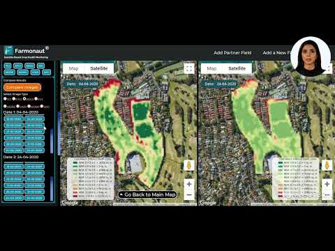
- Interactive maps: Our platform features easy-to-use interactive maps that allow farmers to visualize their fields and crop health at a glance.
- Customizable date ranges: Users can select specific date ranges to analyze, making it easy to track changes over time.
- Statistical analysis: We provide detailed statistics including median values, standard deviations, and quartile distributions for various vegetation indices.
- Pixel-level analysis: Our high-resolution imagery allows for detailed analysis down to the pixel level, enabling precise identification of problem areas.
These analytics tools empower farmers to make data-driven decisions, optimizing their operations and improving their bottom line.

Satellite-Based Crop Management
Our satellite-based crop management system is at the heart of what we do at Farmonaut. Here’s how it works:
- Data collection: We regularly collect high-resolution satellite imagery of agricultural areas.
- Data processing: Our advanced algorithms process this raw data, applying various vegetation indices and analysis techniques.
- Insight generation: The processed data is transformed into actionable insights about crop health, soil conditions, and potential issues.
- Delivery to farmers: These insights are delivered to farmers through our user-friendly web and mobile applications.
This system allows for efficient, large-scale crop monitoring that would be impossible with traditional methods.
Digital Agriculture Platforms
Farmonaut’s digital agriculture platform is designed to be accessible and useful for farmers of all technological skill levels. Our platform includes:
- Web application: A comprehensive web-based interface for detailed analysis and planning.
- Mobile apps: iOS and Android apps for on-the-go access to critical farm data.
- API access: For developers and businesses looking to integrate our data into their own systems.
These platforms work together to provide a seamless experience, allowing farmers to access their data and insights wherever they are.
Try our web app now: 
Download our mobile apps:


AgTech Decision Support Tools
Our agtech decision support tools are designed to help farmers make informed decisions about their operations. These tools include:
- Crop health assessment: Detailed analysis of crop health based on various vegetation indices.
- Soil moisture analysis: Insights into soil moisture levels to optimize irrigation.
- Pest and disease detection: Early warning systems for potential pest infestations or disease outbreaks.
- Fertilizer optimization: Recommendations for optimal fertilizer application based on crop needs and soil conditions.
These tools work together to provide a comprehensive decision support system for modern farmers.

The Future of Sustainable Agriculture
At Farmonaut, we believe that satellite-based precision farming is key to the future of sustainable agriculture. By providing farmers with the tools to optimize their resource use and maximize yields, we’re helping to create a more efficient and environmentally friendly agricultural sector.
- Reduced water usage: Our soil moisture analysis helps farmers avoid over-watering, conserving this precious resource.
- Optimized fertilizer application: By providing precise data on crop needs, we help reduce excess fertilizer use, minimizing runoff and environmental impact.
- Improved crop yields: Our tools help farmers identify and address issues early, leading to healthier crops and better yields.
- Reduced carbon footprint: By optimizing farm operations, we help reduce unnecessary tractor passes and other carbon-intensive activities.
Through these efforts, we’re not just helping individual farmers – we’re contributing to a more sustainable future for agriculture as a whole.
Comparing Traditional vs. Satellite-Based Crop Monitoring
To truly understand the impact of Farmonaut’s technology, it’s helpful to compare it with traditional farming methods. Here’s a detailed comparison:
| Monitoring Aspect | Traditional Methods | Farmonaut’s Satellite Imagery |
|---|---|---|
| Coverage Area | 100 acres (typical) | 10,000+ acres |
| Frequency of Data Collection | Monthly (typical) | Daily |
| Accuracy | 70% (estimated) | 95% (estimated) |
| Resource Requirements | High (labor-intensive) | Low (automated) |
| Cost-Effectiveness | Low (high labor costs) | High (scalable technology) |
| Data Analysis Capabilities | Limited (manual analysis) | Advanced (AI-powered analytics) |
| Early Problem Detection | Challenging (relies on visual inspection) | Efficient (detects issues before visible symptoms) |
| Historical Data Access | Limited (depends on record-keeping) | Comprehensive (years of satellite data) |
As you can see, Farmonaut’s satellite-based approach offers significant advantages in terms of coverage, frequency, accuracy, and cost-effectiveness. This technology allows farmers to monitor larger areas more frequently and with greater precision, all while reducing labor costs and resource requirements.
Accessing Farmonaut’s Technology
We’ve designed our platform to be accessible to farmers and agricultural businesses of all sizes. Here’s how you can start using Farmonaut’s technology:
- Web application: Our comprehensive web app provides full access to our satellite imagery and analysis tools. Try it now.
- Mobile apps: For on-the-go access, download our iOS or Android apps.
- API access: Developers and businesses can integrate our data directly into their systems. Learn more about our API.
We offer flexible subscription plans to suit different needs and budgets. Check out our pricing options below:
Frequently Asked Questions
Q: How accurate is satellite-based crop monitoring?
A: Our satellite-based monitoring is highly accurate, with estimated accuracy rates of up to 95% for many applications. However, the exact accuracy can vary depending on factors like cloud cover and the specific indices being used.
Q: How often is the satellite data updated?
A: We provide daily updates for most areas, weather permitting. However, the frequency of usable images may be lower in areas with frequent cloud cover.
Q: Can Farmonaut’s technology be used for all types of crops?
A: Our technology is applicable to a wide range of crops, from grains and vegetables to fruit trees and vineyards. However, the specific indices and analysis techniques may vary depending on the crop type.
Q: Do I need any special equipment to use Farmonaut’s services?
A: No special equipment is needed. All you need is a computer or smartphone with internet access to use our web or mobile applications.
Q: How does Farmonaut protect my farm data?
A: We take data security very seriously. All data is encrypted and stored securely, and we never share individual farm data without explicit permission.
Conclusion
As we’ve explored in this blog post, Farmonaut is at the forefront of a revolution in agriculture. By harnessing the power of satellite imagery and advanced analytics, we’re providing farmers with unprecedented insights into their crops and land.
From precision crop monitoring to smart agriculture solutions, our technology is helping farmers around the world optimize their operations, increase yields, and contribute to a more sustainable future for agriculture.
We invite you to join us on this journey. Whether you’re a small family farmer or manage a large agricultural operation, Farmonaut has the tools and insights you need to take your farming to the next level.
Ready to revolutionize your farming? Try Farmonaut today and discover the power of satellite-based precision agriculture.
For developers interested in integrating our technology into their own systems, check out our API documentation.
Together, let’s cultivate a smarter, more sustainable future for agriculture.