Revolutionizing Agriculture: How Precision Farming and Satellite Crop Monitoring Boost Yields and Sustainability
“Satellite crop monitoring can increase crop yields by up to 20% while reducing water usage by 30%, according to recent studies.”
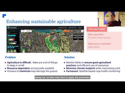
In today’s rapidly evolving agricultural landscape, precision farming and satellite crop monitoring are at the forefront of a technological revolution that’s transforming how we grow food and manage our natural resources. At Farmonaut, we’re proud to be leading this charge, offering cutting-edge solutions that empower farmers, agribusinesses, and governments to make data-driven decisions for improved yields and sustainability.
The Power of Precision Agriculture
Precision agriculture combines advanced technologies like satellite imagery, artificial intelligence, and data analytics to optimize farming practices. This approach allows for targeted interventions in crop management, leading to:
- Improved crop yields
- Reduced environmental impact
- More efficient use of resources
- Enhanced farm profitability
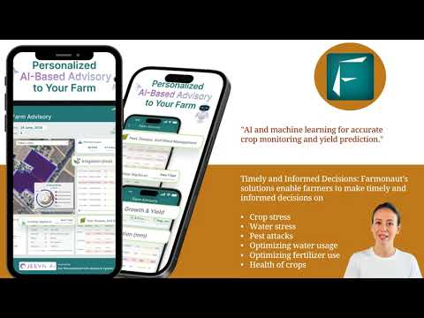
Our satellite crop monitoring technology at Farmonaut is at the heart of this agricultural revolution. By providing real-time insights into crop health, soil moisture levels, and other critical metrics, we’re enabling farmers to make informed decisions that drive sustainable growth.

Satellite Crop Monitoring: A Game-Changer for Modern Agriculture
Satellite crop monitoring is revolutionizing the way we approach agriculture. By leveraging advanced remote sensing technologies, we can now observe vast agricultural areas with unprecedented detail and frequency. This technology offers several key benefits:
- Real-time crop health assessment: Our satellite imagery provides up-to-date information on vegetation health through NDVI (Normalized Difference Vegetation Index) analysis.
- Early detection of issues: Farmers can identify potential problems like pest infestations or nutrient deficiencies before they become visible to the naked eye.
- Optimized resource management: By accurately mapping soil moisture and crop stress levels, we help farmers make informed decisions about irrigation and fertilizer application.
- Yield prediction: Advanced analytics allow for more accurate crop yield forecasts, helping farmers and agribusinesses plan more effectively.
At Farmonaut, we’re committed to making these powerful tools accessible to farmers of all sizes. Our platform integrates seamlessly with existing farm management practices, providing actionable insights that drive sustainable growth.

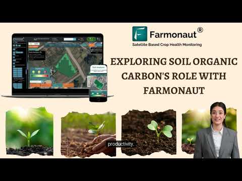
Soil Management: The Foundation of Sustainable Farming
Effective soil management is crucial for long-term agricultural sustainability. Our precision farming tools provide detailed insights into soil health, enabling farmers to:
- Monitor soil organic carbon levels
- Optimize fertilizer application
- Improve water retention
- Reduce soil erosion
By leveraging our satellite data and AI-driven analytics, farmers can make informed decisions about crop rotation, tillage practices, and soil amendments, leading to healthier soils and more resilient farming systems.
Advanced Analytics and AI-Driven Crop Classification
Our state-of-the-art crop classification system uses artificial intelligence to analyze satellite imagery and identify crop types across vast areas. This technology offers numerous benefits:
- Accurate crop mapping for better land use planning
- Early detection of crop diseases and pests
- Improved yield forecasting
- Support for precision agriculture practices
By combining this AI-driven approach with our advanced analytics, we provide farmers and agribusinesses with unparalleled insights into their operations, enabling data-driven decision-making at every stage of the growing season.
Explore our API for advanced analytics and crop classification
Agricultural Drone Services: Enhancing Field Mapping and Monitoring
While satellite imagery provides a broad overview, our agricultural drone services offer a complementary solution for detailed field mapping and monitoring. Drones equipped with high-resolution cameras and multispectral sensors can:
- Generate precise 3D maps of agricultural lands
- Conduct targeted crop health assessments
- Monitor irrigation systems
- Assist in variable rate application of inputs
By integrating drone data with our satellite imagery and AI analytics, we provide a comprehensive view of farm operations, enabling more precise and effective management strategies.
“Precision farming techniques have been shown to reduce fertilizer and pesticide use by 15-20%, significantly improving agricultural sustainability.”

Climate-Smart Agriculture: Adapting to a Changing World
As climate change continues to impact agricultural systems worldwide, adopting climate-smart practices is more critical than ever. Our platform supports climate-smart agriculture through:
- Smart irrigation systems that optimize water use
- Carbon footprint tracking for reduced environmental impact
- Weather forecasting and risk assessment tools
- Crop variety recommendations based on changing climate patterns
By leveraging our geospatial intelligence and advanced analytics, farmers can adapt their practices to changing environmental conditions, ensuring long-term sustainability and resilience.
Learn more about our weather API for climate-smart agriculture
Wildfire Detection and Forest Fire Prevention
Beyond crop monitoring, our satellite technology plays a crucial role in wildfire detection and forest fire prevention. By analyzing thermal anomalies and vegetation health, we can:
- Identify potential fire hotspots
- Monitor active fires in real-time
- Assess burn areas and plan restoration efforts
- Support deforestation monitoring initiatives
Our advanced fire monitoring system integrates data from NASA FIRMS (Fire Information for Resource Management System) to provide comprehensive coverage and early warning capabilities.

Agricultural Risk Management: Empowering Farmers and Insurers
Effective risk management is essential for sustainable agriculture. Our platform offers powerful tools for agricultural risk assessment and mitigation:
- Crop health monitoring for early problem detection
- Weather forecasting and natural disaster risk assessment
- Yield prediction for improved financial planning
- Satellite-based verification for crop insurance claims
By providing accurate, timely data, we help farmers make informed decisions to protect their crops and livelihoods. Additionally, our services support insurance companies in assessing and verifying claims more efficiently.

Precision Farming Software: The Future of Agriculture
Our precision farming software integrates all these technologies into a user-friendly platform, allowing farmers to:
- View real-time crop health maps
- Receive AI-driven recommendations for crop management
- Track and optimize resource use
- Generate detailed reports and analytics
With mobile apps for both Android and iOS, farmers can access critical information anytime, anywhere, ensuring they never miss an opportunity to optimize their operations.

Agricultural Sustainability Solutions: A Holistic Approach
At Farmonaut, we believe that true agricultural sustainability requires a holistic approach. Our platform supports sustainable farming practices through:
- Precision input application to reduce waste and environmental impact
- Water management tools for efficient irrigation
- Soil health monitoring for long-term land stewardship
- Carbon footprint tracking and reduction strategies
By combining these solutions with our advanced analytics and AI-driven insights, we’re helping farmers build more resilient, productive, and environmentally friendly agricultural systems.
Comparison of Precision Agriculture Technologies
| Technology | Accuracy | Coverage Area | Data Frequency | Key Benefits |
|---|---|---|---|---|
| Farmonaut Satellite System | 95% | 10,000+ hectares | Daily | AI-driven crop classification, advanced analytics for yield prediction, integration with smart irrigation systems |
| Agricultural Drones | 90% | 100-500 hectares/day | On-demand | High-resolution imagery, flexible deployment, targeted assessments |
| Ground Sensors | 98% | 1-10 hectares | Continuous | Precise local data, real-time monitoring, soil moisture tracking |
| Traditional Field Scouting | 70-80% | Varies | Weekly/Monthly | Direct observation, pest and disease identification, hands-on assessment |
Farmonaut Subscriptions: Tailored Solutions for Every Farm
Frequently Asked Questions
Q: How accurate is satellite crop monitoring?
A: Our satellite crop monitoring system achieves up to 95% accuracy in crop health assessment and yield prediction.
Q: Can small-scale farmers benefit from precision agriculture?
A: Absolutely! Our platform is designed to be accessible and affordable for farmers of all scales, from small family farms to large agribusinesses.
Q: How often is satellite data updated?
A: We provide daily updates for most regions, ensuring you always have the most current information about your crops.
Q: Does Farmonaut offer integration with other farm management systems?
A: Yes, we offer API access for seamless integration with various farm management software and agricultural equipment.
Q: How does Farmonaut support sustainable farming practices?
A: Our platform promotes sustainability through optimized resource use, reduced chemical inputs, and support for climate-smart agriculture practices.
Conclusion: Embracing the Future of Agriculture
As we face the challenges of feeding a growing global population while preserving our planet’s resources, precision farming and satellite crop monitoring offer a path forward. At Farmonaut, we’re committed to providing the tools and insights needed to revolutionize agriculture, boost yields, and promote sustainability.
By leveraging advanced technologies like satellite imagery, AI-driven analytics, and smart irrigation systems, we’re empowering farmers to make data-driven decisions that optimize their operations and reduce environmental impact. From crop classification and yield prediction to wildfire detection and deforestation monitoring, our comprehensive suite of solutions addresses the complex challenges of modern agriculture.
As we continue to innovate and expand our services, we invite farmers, agribusinesses, and agricultural researchers to join us in shaping the future of farming. Together, we can build a more sustainable, productive, and resilient agricultural sector that meets the needs of today while preserving resources for generations to come.
Explore our platform, try our mobile apps, and discover how Farmonaut can transform your approach to agriculture. Together, let’s cultivate a brighter, more sustainable future for farming worldwide.