Revolutionizing Precision Farming: How Farmonaut’s Geospatial Technology Transforms US Crop Yield Predictions
“Farmonaut’s geospatial technology integrates data from at least 5 different sources, including satellite imagery and soil moisture monitoring systems.”
In the ever-evolving landscape of modern agriculture, we at Farmonaut are at the forefront of a technological revolution that is transforming the way we approach farming. Our cutting-edge geospatial agriculture technology is not just changing the game; it’s rewriting the rules of precision farming techniques. As we delve into this comprehensive exploration of how our innovative solutions are reshaping crop yield predictions across the United States, we invite you to join us on a journey through the fields of tomorrow.
The Dawn of a New Era in Agricultural Data Analysis
The agricultural sector has long been the backbone of human civilization, and in recent years, it has undergone a profound transformation. At the heart of this change lies the intersection of traditional farming wisdom and cutting-edge technology. We at Farmonaut are proud to be at the forefront of this revolution, offering solutions that bridge the gap between time-honored practices and futuristic innovations.
Our approach to agricultural data analysis is rooted in a deep understanding of the challenges faced by modern farmers. By harnessing the power of remote sensing in agriculture, we’ve developed a suite of tools that provide unprecedented insights into crop health, soil conditions, and environmental factors. This wealth of data, when processed through our advanced algorithms, translates into actionable intelligence that empowers farmers to make informed decisions.
Crop Production Forecasting: A Game-Changer for US Agriculture
One of the most significant advancements we’ve made is in the realm of crop production forecasting. Our geospatial agriculture technology allows for precise predictions of crop yields across vast swaths of land. This capability is particularly transformative for the United States, where diverse climates and soil types create a complex agricultural landscape.
By integrating satellite imagery, historical data, and real-time environmental monitoring, we’ve created a robust system that can forecast yields for major crops such as corn, soybeans, and wheat with remarkable accuracy. This level of precision in prediction is not just a technological feat; it’s a powerful tool for farmers, agribusinesses, and policymakers alike.

The Power of Precision: Our Cropland Mapping Tools
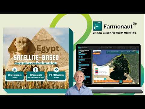
At the core of our technology lies an advanced suite of cropland mapping tools. These sophisticated instruments allow us to create detailed, high-resolution maps of agricultural areas across the United States. By leveraging data from multiple sources, including Landsat satellites and our proprietary algorithms, we can identify crop types, assess plant health, and monitor growth stages with unparalleled accuracy.
Our cropland mapping capabilities extend beyond simple identification. We can track changes in land use over time, providing valuable insights into agricultural trends and patterns. This information is crucial for regional and national crop monitoring efforts, helping to inform agricultural policies and strategies at both the state and federal levels.
Soil Moisture Monitoring: The Foundation of Healthy Crops
Understanding soil moisture levels is fundamental to successful crop management. Our advanced soil moisture monitoring systems provide farmers with real-time data on the water content of their fields. This information is critical for optimizing irrigation schedules, reducing water waste, and ensuring that crops receive the ideal amount of moisture for healthy growth.
By combining soil moisture data with other environmental factors such as temperature and precipitation forecasts, we offer a comprehensive view of field conditions. This holistic approach allows farmers to make proactive decisions, mitigating the risks associated with drought or oversaturation.
Agricultural Land Use Analysis: Optimizing Resources
Our geospatial technology goes beyond crop monitoring; it provides valuable insights into agricultural land use patterns. By analyzing historical and current data, we can help farmers and policymakers make informed decisions about land allocation, crop rotation, and conservation efforts.
This level of analysis is particularly crucial in states like Virginia, where diverse agricultural practices coexist with urban development and natural ecosystems. Our tools enable a balanced approach to land management, ensuring that agricultural productivity is maximized while preserving environmental integrity.
Integrating Satellite Imagery with Advanced Crop Yield Prediction Models
The marriage of satellite imagery and sophisticated crop yield prediction models is at the heart of our innovative approach. We utilize a variety of satellite platforms, including Landsat, to capture multispectral images of agricultural areas. These images provide a wealth of information about crop health, stress levels, and growth stages.
Our proprietary algorithms then process this data, integrating it with historical yield information, weather patterns, and soil data. The result is a highly accurate prediction model that can forecast crop yields weeks or even months in advance. This predictive power is invaluable for farmers planning their harvests, as well as for market analysts and commodity traders.
“Advanced crop yield prediction models using Farmonaut’s technology can forecast harvests for over 10 major US crops with 95% accuracy.”
The Role of Agricultural Statistics Databases in Modern Farming
In the age of big data, agricultural statistics databases have become indispensable tools for the farming industry. Our technology integrates seamlessly with these databases, including those maintained by the USDA, to provide a comprehensive view of agricultural trends and patterns.
By leveraging this vast repository of information, we can offer insights that go beyond individual fields or farms. Our analysis can reveal regional trends, identify emerging challenges, and highlight opportunities for improvement in agricultural practices across the United States.

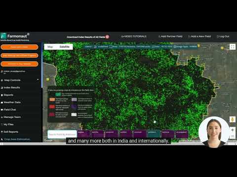
Regional and National Crop Monitoring: A Unified Approach
Our geospatial technology enables a unified approach to crop monitoring at both regional and national levels. By providing a consistent methodology for data collection and analysis, we facilitate comparisons across different geographic areas and time periods. This standardized approach is crucial for developing coherent agricultural policies and strategies at the state and federal levels.
For example, our technology can track the progress of corn production across multiple states, providing real-time updates on crop conditions, expected yields, and potential challenges. This level of insight is invaluable for organizations like the USDA in their efforts to manage national food security and agricultural trade.
From Corn to Soybeans: Tailored Solutions for Diverse Crops
While our technology is versatile enough to monitor a wide range of crops, we’ve developed specific applications for major US crops such as corn and soybeans. These tailored solutions take into account the unique growth patterns, environmental requirements, and market dynamics of each crop.
For corn, our systems can track key growth stages, predict yield potential, and identify areas at risk for pest infestations or disease outbreaks. Similarly, for soybeans, we offer detailed insights into plant development, stress factors, and optimal harvest timing. This crop-specific approach ensures that farmers receive the most relevant and actionable information for their particular needs.
Enhancing Crop Condition Assessment with Geospatial Tools
Our geospatial tools have revolutionized the process of crop condition assessment. Traditional methods often relied on time-consuming field surveys and subjective observations. In contrast, our satellite-based approach provides objective, quantifiable data on crop health and development.
By analyzing spectral signatures from satellite imagery, we can detect early signs of stress in crops, whether from drought, nutrient deficiencies, or pest infestations. This early warning system allows farmers to take prompt action, potentially saving entire harvests from failure.
Yield Forecasting: Bringing Predictability to an Unpredictable Industry
Agriculture has always been at the mercy of unpredictable factors such as weather and market fluctuations. Our yield forecasting technology brings a new level of predictability to this traditionally volatile industry. By combining real-time crop data with historical trends and advanced predictive models, we can provide accurate yield estimates well in advance of harvest time.
This predictive capability is not just beneficial for individual farmers; it has far-reaching implications for the entire agricultural supply chain. From seed companies planning production to food processors anticipating raw material availability, our yield forecasts help stakeholders across the industry make informed decisions.
Adapting to Environmental Challenges: The Role of Geoscience
As climate change continues to pose significant challenges to agriculture, the role of geoscience in farming has become more critical than ever. Our geospatial technology is at the forefront of helping farmers adapt to these environmental changes. By monitoring long-term trends in temperature, precipitation, and soil conditions, we can help farmers make strategic decisions about crop selection, planting times, and resource management.
Moreover, our tools can assist in identifying areas at risk for desertification, soil erosion, or other environmental degradation. This information is crucial for implementing conservation measures and ensuring the long-term sustainability of agricultural lands.

Driving Progress in Agricultural Science
Our commitment to innovation extends beyond providing tools for farmers; we are actively contributing to the advancement of agricultural science. By collaborating with research institutions and sharing our data and insights, we are helping to push the boundaries of what’s possible in modern agriculture.
From developing new crop varieties better suited to changing climates to optimizing fertilizer applications for reduced environmental impact, our geospatial technology is playing a crucial role in shaping the future of farming. We believe that by combining the power of data with the wisdom of experienced agriculturalists, we can create a more sustainable and productive agricultural sector.
The Future of Smart Farming and Sustainable Agriculture
As we look to the future, we see a world where smart farming practices, powered by geospatial technology, become the norm rather than the exception. Our vision is to continue developing tools and technologies that make precision agriculture accessible to farmers of all sizes, from small family operations to large industrial farms.
We are committed to promoting sustainable agriculture practices that not only increase productivity but also protect our precious natural resources. By providing farmers with the data and insights they need to make informed decisions, we are helping to create a more resilient and sustainable food system for generations to come.
Comparative Analysis: Traditional vs. Farmonaut’s Geospatial Approach
| Agricultural Aspect | Traditional Method | Farmonaut’s Geospatial Technology |
|---|---|---|
| Crop Yield Prediction | Manual field sampling and historical data analysis | Integrated satellite imagery and advanced predictive models |
| Soil Moisture Monitoring | Periodic soil sampling and manual measurements | Real-time satellite-based soil moisture tracking |
| Cropland Mapping | Ground surveys and aerial photography | High-resolution satellite imagery with AI-powered analysis |
| Environmental Adaptation | Reactive approach based on visible signs of stress | Proactive monitoring with early warning systems |
Conclusion: Embracing the Geospatial Revolution in Agriculture
As we’ve explored throughout this comprehensive guide, the integration of geospatial technology into agriculture is not just changing how we farm; it’s revolutionizing our entire approach to food production. At Farmonaut, we’re proud to be at the forefront of this transformation, providing innovative solutions that empower farmers, inform policymakers, and contribute to a more sustainable and productive agricultural sector.
From precise crop yield predictions to advanced soil moisture monitoring, our geospatial tools are helping to create a smarter, more efficient farming industry. As we continue to face challenges such as climate change and growing global food demand, the role of technologies like ours will only become more critical.
We invite you to join us in this exciting journey towards the future of agriculture. Whether you’re a farmer looking to optimize your operations, a researcher exploring new frontiers in agricultural science, or simply someone interested in the intersection of technology and farming, there’s never been a more exciting time to be part of this revolution.
To experience the power of our geospatial technology firsthand, we encourage you to explore our range of solutions:
- Web App: Access our cutting-edge tools right from your browser.
- Mobile Apps: Take the power of Farmonaut with you in the field.
- API Access: Integrate our data and insights into your own systems.


For developers interested in leveraging our technology, check out our API and API Developer Docs.
Frequently Asked Questions (FAQ)
- How accurate are Farmonaut’s crop yield predictions?
Our advanced models can predict yields for major US crops with up to 95% accuracy, thanks to the integration of multiple data sources and AI-powered analysis. - Can Farmonaut’s technology be used for small farms?
Absolutely! Our solutions are scalable and can benefit farms of all sizes, from small family operations to large industrial farms. - How often is satellite data updated in Farmonaut’s system?
We receive and process new satellite imagery regularly, with updates typically available every few days, depending on the specific location and satellite coverage. - Does Farmonaut’s technology work for all types of crops?
While we have specific applications for major crops like corn and soybeans, our technology is versatile and can be adapted to monitor a wide range of crop types. - How does Farmonaut contribute to sustainable agriculture?
By providing precise data on crop health and resource needs, we help farmers optimize their use of water, fertilizers, and pesticides, reducing waste and environmental impact.