Revolutionizing Agriculture: How Satellite Crop Monitoring and Farm Management Software Boost Yields in New York
In the heart of the Empire State, a quiet revolution is taking place in the fields and farms that dot our landscape. We’re witnessing a transformative era where precision agriculture technology is reshaping the way we grow, monitor, and harvest our crops. At the forefront of this agricultural renaissance is the integration of satellite crop monitoring and advanced farm management software, tools that are proving invaluable to farmers across New York and beyond.

“Satellite crop monitoring can increase crop yields by up to 20% through precise management of soil moisture and nutrients.”
The Dawn of Precision Agriculture in New York
As we delve into the world of modern farming, it’s crucial to understand how precision agriculture technology is revolutionizing the agricultural landscape in New York. This innovative approach combines satellite crop monitoring, geospatial intelligence, and advanced farm management software to optimize every aspect of crop production.
Embracing Satellite Technology for Crop Monitoring
One of the most significant advancements in agricultural technology is the use of satellite imagery for crop monitoring. This technology allows farmers to:
- Observe crop health from space
- Detect early signs of pest infestations or disease
- Analyze soil moisture levels across vast areas
- Make informed decisions about irrigation and fertilization
By leveraging these capabilities, farmers in New York can significantly improve their crop yields while minimizing resource waste. This is particularly important in our state, where diverse crops from apples in the Hudson Valley to corn in the Finger Lakes region require tailored management approaches.
The Role of Farm Management Software
Farm management software serves as the central nervous system of modern agricultural operations. These sophisticated platforms integrate data from various sources, including satellites, weather stations, and on-ground sensors, to provide farmers with actionable insights. Key features often include:
- Crop yield prediction
- Field scouting tools
- Variable rate application planning
- Harvest optimization techniques
By adopting these smart farming solutions, New York’s agricultural sector is positioning itself at the forefront of technological innovation in farming.

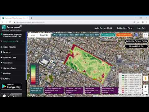
Soil Moisture Analysis: The Foundation of Precision Agriculture
Soil moisture analysis is a cornerstone of effective crop management. In New York, where rainfall patterns can vary significantly across regions, understanding soil moisture levels is crucial for:
- Optimizing irrigation schedules
- Preventing water stress in crops
- Reducing water waste and associated costs
- Improving overall crop health and yield potential
Advanced satellite crop monitoring systems can provide accurate soil moisture data across large areas, allowing farmers to make informed decisions about water management. This is particularly beneficial in regions like the Mohawk Valley and Southern Tier, where efficient water use is essential for sustainable agriculture.
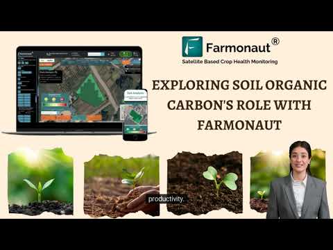
The Impact of Soil Organic Carbon on Crop Health
Another critical aspect of soil health is the presence of organic carbon. Satellite-based technologies now enable farmers to assess soil organic carbon levels, which are vital for:
- Enhancing soil structure and water retention
- Improving nutrient availability to crops
- Increasing resilience to climate change
- Promoting sustainable farming practices
By monitoring and managing soil organic carbon, New York farmers can contribute to both improved crop yields and environmental sustainability.
Crop Yield Prediction: Harnessing the Power of Data
Crop yield prediction is no longer a guessing game. With advanced agricultural data analytics, farmers can now forecast their harvests with unprecedented accuracy. This capability is transforming farm management in several ways:
- Improved planning for harvest logistics
- Better informed marketing and sales strategies
- Enhanced ability to secure financing and insurance
- More accurate budgeting and resource allocation
In New York, where crops range from dairy-supporting forage to high-value fruits and vegetables, accurate yield predictions are invaluable for farm profitability and sustainability.
Remote Sensing in Agriculture: Beyond the Visible Spectrum
Remote sensing in agriculture has expanded far beyond simple visual observation. Today’s satellite and drone-based sensors can detect:
- Plant stress before visible symptoms appear
- Nutrient deficiencies across fields
- Areas affected by pests or diseases
- Variations in crop maturity and readiness for harvest
This wealth of information enables New York farmers to practice precision agriculture at a level previously unimaginable, leading to more efficient use of resources and higher quality produce.

Sustainable Farming Practices: A New York Imperative
As stewards of the land, New York farmers are increasingly adopting sustainable farming practices. The integration of satellite crop monitoring and farm management software plays a crucial role in this shift towards sustainability by:
- Reducing water usage through precision irrigation systems
- Minimizing chemical inputs with variable rate application
- Promoting soil health through data-driven crop rotation
- Enhancing biodiversity and ecosystem services on farmland
These practices not only benefit the environment but also contribute to the long-term viability of farming in our state.
Climate-Smart Agriculture: Adapting to Change
Climate-smart agriculture is becoming increasingly important as New York faces the challenges of a changing climate. Advanced farm management software and satellite crop monitoring tools help farmers:
- Adapt to shifting weather patterns
- Mitigate the impacts of extreme weather events
- Reduce greenhouse gas emissions from farming operations
- Increase carbon sequestration in agricultural soils
By embracing these technologies, New York’s agricultural sector is positioning itself as a leader in climate-resilient farming practices.
“Geospatial analytics in agriculture can reduce water usage by 30% while maintaining or improving crop productivity.”
The Role of Agricultural Drones in Modern Farming
While satellites provide a broad view, agricultural drone applications offer a more detailed perspective on crop health and field conditions. In New York, drones are increasingly used for:
- High-resolution crop imaging
- Targeted pesticide and fertilizer application
- Rapid assessment of storm damage
- Monitoring of hard-to-reach areas
The integration of drone data with satellite imagery and on-ground sensors creates a comprehensive picture of farm health, enabling more precise and timely interventions.
Agricultural Weather Forecasting: A Game-Changer for Farmers
Accurate agricultural weather forecasting is crucial for effective farm management. Advanced farm management software now incorporates sophisticated weather prediction models that provide:
- Hyperlocal weather forecasts
- Frost and heat stress warnings
- Precipitation predictions for irrigation planning
- Long-term climate trend analysis
This level of precision in weather forecasting allows New York farmers to make proactive decisions that protect crops and optimize resource use.
Geospatial Analytics: Transforming Agricultural Decision-Making
Geospatial analytics for agriculture is revolutionizing how farmers approach land management. By analyzing spatial data from various sources, farmers can:
- Identify optimal planting zones within fields
- Track crop growth patterns over time
- Assess the impact of topography on crop performance
- Plan efficient field operations and logistics
This data-driven approach is particularly valuable in New York’s diverse agricultural landscape, where conditions can vary significantly even within a single farm.
Crop Classification Using Satellites: Enhancing Agricultural Intelligence
Crop classification using satellites is an emerging technology that offers numerous benefits to the agricultural sector:
- Accurate crop inventory at regional and state levels
- Early detection of invasive species or unauthorized crops
- Improved supply chain management for processors and distributors
- Enhanced ability to monitor crop rotation practices
For New York’s agricultural planners and policymakers, this technology provides valuable insights into crop diversity and land use patterns across the state.
Comparing Traditional and Satellite-Enabled Farm Management
| Farm Management Aspect | Traditional Methods | Farmonaut Satellite System |
|---|---|---|
| Crop Health Monitoring | Visual inspection, limited coverage | Comprehensive, real-time satellite imagery |
| Soil Moisture Analysis | Spot checks, time-consuming | Wide-area analysis, frequent updates |
| Yield Prediction Accuracy | ±20-30% typical error | ±5-10% improved accuracy |
| Field Scouting Efficiency | Time-intensive, limited coverage | Targeted, data-driven approach |
| Weather Forecasting Integration | General regional forecasts | Field-specific, AI-enhanced predictions |
| Precision Irrigation | Scheduled, uniform application | Variable rate, needs-based application |
| Variable Rate Application | Limited or manual adjustments | Automated, data-driven prescriptions |
| Time Savings | Baseline | Up to 50% reduction in management time |
| Cost Efficiency | Variable, often higher input costs | 15-20% reduction in input costs |
| Sustainability Impact | Limited optimization | Significant reduction in resource use |
The Future of Agriculture in New York
As we look to the future, the integration of satellite crop monitoring and advanced farm management software is set to play an even more significant role in New York’s agricultural sector. We can expect to see:
- Increased adoption of AI and machine learning in farming decisions
- Greater integration of IoT devices with satellite data
- Enhanced collaboration between farmers, researchers, and technology providers
- More sustainable and resilient farming practices driven by data insights
These advancements will not only boost yields but also contribute to the long-term sustainability and profitability of farming in our state.
Embracing Innovation with Farmonaut
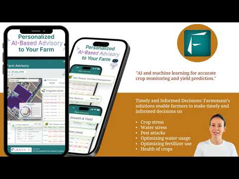
In the realm of satellite crop monitoring and farm management software, Farmonaut stands out as a pioneering solution. Their platform offers:
- Advanced satellite-based crop health monitoring
- AI-driven advisory systems for personalized farm management
- Blockchain-based traceability for enhanced supply chain transparency
- Comprehensive resource management tools for optimized operations
By leveraging Farmonaut’s technology, New York farmers can access affordable and powerful precision agriculture tools that were once only available to large agricultural corporations.
Explore Farmonaut’s offerings:


For developers and businesses looking to integrate Farmonaut’s capabilities into their own systems, explore the Farmonaut API and API Developer Docs.
Frequently Asked Questions
- How does satellite crop monitoring improve farm efficiency?
Satellite crop monitoring provides real-time data on crop health, allowing for timely interventions and optimized resource use. - Can small farms in New York benefit from this technology?
Yes, Farmonaut’s solutions are designed to be accessible and affordable for farms of all sizes. - How accurate is satellite-based soil moisture analysis?
Modern satellite technology can provide soil moisture estimates with accuracy levels approaching 90% in many cases. - What types of crops in New York can benefit from this technology?
Virtually all crops grown in New York, from grains to fruits and vegetables, can benefit from satellite-based monitoring and management. - How does this technology contribute to sustainable farming?
By optimizing resource use and reducing waste, satellite-based farm management significantly enhances agricultural sustainability.
Conclusion: A New Era for New York Agriculture
The integration of satellite crop monitoring and advanced farm management software is ushering in a new era of agriculture in New York. By embracing these technologies, our farmers are not only boosting yields but also promoting sustainability, enhancing food security, and securing the future of farming in our state. As we continue to innovate and adapt, New York’s agricultural sector is poised to lead the way in smart, efficient, and sustainable food production for generations to come.