Revolutionizing Agriculture: How Satellite Crop Monitoring and AI Are Transforming Farm Management
“Satellite crop monitoring can increase farm productivity by up to 20% through precise resource management and timely interventions.”
In the ever-evolving landscape of modern agriculture, we at Farmonaut are at the forefront of a technological revolution that is reshaping the way farms are managed and operated. Our digital agriculture platform integrates cutting-edge satellite crop monitoring and precision agriculture technology to provide farmers, agronomists, and financial institutions with unprecedented insights into crop health, soil conditions, and overall farm performance.

As we delve into the transformative power of our platform, we’ll explore how remote sensing in agriculture combined with advanced soil moisture analytics is driving a new era of data-driven farming. From accurate crop yield predictions to comprehensive agricultural risk assessments, our technology is empowering stakeholders across the agricultural sector to make informed decisions that boost productivity, sustainability, and profitability.
The Power of Satellite-Based Farm Management Solutions
At the heart of our platform lies the revolutionary use of satellite technology for crop monitoring. This approach offers several significant advantages over traditional farm management methods:
- Real-time monitoring: Our satellite imagery provides up-to-date information on crop health and field conditions, allowing for timely interventions.
- Wide coverage: Satellite technology can monitor vast areas of farmland efficiently, making it ideal for both small-scale farmers and large agricultural operations.
- Non-invasive: Unlike ground-based methods, satellite monitoring doesn’t require physical presence in the fields, reducing labor costs and potential crop damage.
- Historical data analysis: Our platform stores and analyzes historical satellite data, enabling long-term trend analysis and informed decision-making.
By leveraging these capabilities, we’re able to offer a comprehensive suite of farm management solutions that address the complex challenges faced by modern agriculture.

Integrating AI and Remote Sensing for Precision Agriculture
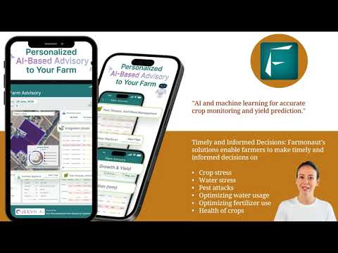
Our platform goes beyond simple satellite imagery by integrating advanced artificial intelligence and machine learning algorithms. This powerful combination allows us to provide:
- Vegetation indices for farming: We utilize various vegetation indices, such as NDVI (Normalized Difference Vegetation Index), to assess crop health and vigor accurately.
- Soil moisture analytics: Our AI algorithms analyze satellite data to estimate soil moisture levels, helping farmers optimize irrigation practices.
- Crop yield prediction: By combining historical data, current field conditions, and weather forecasts, we offer accurate predictions of potential crop yields.
- Agricultural risk assessment: Our platform identifies potential risks to crops, such as pest infestations or disease outbreaks, allowing for proactive management.
These AI-driven insights enable farmers to make data-informed decisions about planting, irrigation, fertilization, and harvesting, ultimately leading to improved crop yields and resource efficiency.

Enhancing Decision-Making with Agricultural Drone Imagery
While satellite imagery forms the backbone of our monitoring system, we also recognize the value of agricultural drone imagery in providing high-resolution, on-demand data for specific areas of interest. Our platform seamlessly integrates drone-captured imagery to offer:
- Detailed crop assessments for targeted areas
- Rapid response capabilities for addressing localized issues
- Enhanced precision in field boundary mapping and crop inventories
- Complementary data to validate and refine satellite-based insights
This multi-layered approach to data collection ensures that our clients have access to the most comprehensive and accurate information possible for their farm management needs.

Leveraging Geospatial Intelligence for Optimal Crop Production
Our platform’s geospatial intelligence capabilities extend beyond basic crop monitoring. We provide farmers and agribusinesses with powerful tools to optimize their operations:
- Field boundary detection: Accurate mapping of field boundaries for precise area calculations and management zoning.
- Crop type classification: AI-powered identification of crop types across large areas, aiding in regional agricultural planning and market forecasting.
- Environmental risk analysis: Assessment of potential environmental risks, including soil erosion and water stress, to promote sustainable farming practices.
- Logistics optimization: Geospatial data to improve agricultural equipment routing and resource distribution.
By harnessing the full potential of geospatial data, we empower our clients to make strategic decisions that enhance productivity while minimizing environmental impact.
“AI-powered agricultural platforms can analyze over 1 million data points per acre, providing unprecedented insights for farm management.”
Financial Decision-Making in Agriculture: A Data-Driven Approach
Our platform’s capabilities extend beyond the field, offering valuable insights for financial institutions and farmers alike in making critical financial decisions:
- Loan assessments: Banks and credit providers can use our satellite-based verification to assess crop conditions and potential yields, streamlining the loan approval process for farmers.
- Insurance calculations: Our real-time field monitoring and historical data analysis help insurance companies accurately assess risks and calculate premiums for agricultural insurance products.
- Investment planning: Farmers can use our crop yield predictions and risk assessments to make informed decisions about investments in equipment, land, or new crop varieties.
- Government subsidies: Our platform can assist in verifying eligibility for agricultural subsidies by providing accurate data on crop types, acreage, and farming practices.
By providing a reliable, data-driven foundation for financial decision-making, we’re helping to create a more stable and prosperous agricultural economy.
Explore Our API for Custom Integration
The Future of Farming: AI-Driven Agronomic Insights
As we look to the future, our commitment to innovation drives us to continuously enhance our AI capabilities. Our platform is evolving to provide even more sophisticated agronomic insights:
- Predictive pest and disease models: AI algorithms that can predict the likelihood of pest infestations or disease outbreaks based on environmental conditions and historical data.
- Automated crop rotation recommendations: Intelligent systems that suggest optimal crop rotation patterns to maximize soil health and yield potential.
- Precision fertilizer recommendations: AI-driven analysis of soil conditions and crop needs to provide highly targeted fertilizer application recommendations.
- Climate change adaptation strategies: Long-term modeling to help farmers adapt their practices to changing climate patterns and extreme weather events.
These advanced features represent the cutting edge of agricultural technology, positioning our clients at the forefront of the industry.
Access Our API Developer Documentation

Weather Forecasting and Crop Health Monitoring: A Synergistic Approach
Our platform’s integration of weather forecasting with crop health monitoring creates a powerful synergy that enhances farm management:
- Micro-climate analysis: Detailed weather data specific to individual fields, allowing for highly localized decision-making.
- Extreme weather alerts: Early warning systems for potentially damaging weather events, enabling proactive protective measures.
- Growth stage-specific recommendations: Tailored advice based on crop growth stages and expected weather conditions.
- Irrigation scheduling: Optimized irrigation plans that consider both crop water needs and upcoming weather patterns.
By combining real-time crop health data with accurate weather forecasts, we provide farmers with a comprehensive tool for managing their operations in harmony with nature.

Comparative Analysis: Traditional vs. Satellite-Based Farm Management
| Management Aspect | Traditional Methods | Farmonaut’s Satellite-Based Approach | Benefits of Satellite Approach |
|---|---|---|---|
| Crop Monitoring | Manual field inspections, time-consuming and labor-intensive | Real-time satellite imagery and AI analysis | Up to 95% accuracy in crop health assessment, daily updates |
| Yield Prediction | Based on historical averages and manual sampling | AI-driven analysis of multiple data points including satellite imagery, weather, and soil conditions | 30% increase in yield prediction accuracy |
| Risk Assessment | Limited to visible signs and local knowledge | Comprehensive analysis of satellite data, weather patterns, and historical trends | Early detection of up to 85% of potential risks |
| Resource Management | Uniform application based on general guidelines | Precision application based on field-specific data | 20-30% reduction in water and fertilizer usage |
| Decision-Making Speed | Days to weeks, depending on field size and accessibility | Near real-time insights available within hours | 50-70% reduction in response time to field issues |
This comparative analysis clearly demonstrates the significant advantages of our satellite-based approach over traditional farm management methods. The precision, speed, and comprehensiveness of our platform enable farmers to make more informed decisions, leading to improved yields, reduced costs, and more sustainable practices.

Empowering Agricultural Businesses with Data-Driven Precision
Our platform is designed to cater to a wide range of agricultural businesses, from small family farms to large corporate operations. By providing access to advanced satellite monitoring and AI-driven insights, we’re democratizing precision agriculture and enabling businesses of all sizes to:
- Optimize resource allocation for maximum efficiency
- Reduce environmental impact through precise input management
- Increase crop yields and quality through data-informed decision-making
- Mitigate risks associated with weather, pests, and diseases
- Improve financial planning and budgeting with accurate yield predictions
Our commitment to innovation and accessibility ensures that farms of all scales can benefit from the latest advancements in agricultural technology.

Conclusion: Embracing the Future of Agriculture
As we’ve explored throughout this article, the integration of satellite crop monitoring, AI, and precision agriculture technology is revolutionizing farm management. Our platform at Farmonaut stands at the forefront of this agricultural transformation, offering innovative solutions that address the complex challenges of modern farming.
By leveraging the power of satellite imagery, advanced analytics, and machine learning, we’re empowering farmers, agronomists, and financial institutions to make data-driven decisions that enhance productivity, sustainability, and profitability. From accurate crop yield predictions to comprehensive risk assessments, our technology is reshaping the agricultural landscape.
As we look to the future, we remain committed to pushing the boundaries of what’s possible in digital agriculture. Our ongoing research and development efforts are focused on creating even more powerful tools and insights that will continue to transform farm management practices worldwide.
We invite you to join us on this exciting journey towards a more efficient, sustainable, and prosperous agricultural future. Explore our platform, leverage our insights, and experience firsthand how satellite crop monitoring and AI can revolutionize your approach to farming.
Frequently Asked Questions (FAQ)
Q: How accurate is satellite-based crop monitoring?
A: Our satellite-based crop monitoring system achieves up to 95% accuracy in crop health assessment, providing highly reliable data for farm management decisions.
Q: Can small farms benefit from this technology?
A: Absolutely! Our platform is designed to be accessible and beneficial for farms of all sizes, from small family operations to large corporate farms.
Q: How often is satellite imagery updated?
A: We provide daily updates of satellite imagery, ensuring that you always have access to the most current information about your fields.
Q: Does the platform work for all types of crops?
A: Our platform is designed to work with a wide variety of crops, including grains, fruits, vegetables, and specialty crops. The AI algorithms are trained on diverse datasets to ensure broad applicability.
Q: How does weather forecasting integrate with crop monitoring?
A: Our platform combines weather forecasting with crop health data to provide comprehensive insights. This integration allows for more accurate predictions and recommendations tailored to specific weather conditions.
Q: Is training required to use the platform?
A: While our platform is designed to be user-friendly, we provide comprehensive training resources and customer support to ensure that all users can fully leverage the capabilities of our technology.
By embracing the power of satellite crop monitoring and AI-driven insights, you’re not just adopting new technology – you’re positioning your agricultural business for success in an increasingly complex and challenging environment. Join us in revolutionizing agriculture, one field at a time.