Revolutionizing Agriculture: How Farmonaut’s Cloud-Based Satellite Imagery Enhances Precision Farming
“Farmonaut’s cloud-based satellite imagery system processes data from over 10,000 agricultural fields daily, enhancing precision farming practices.”
In the ever-evolving landscape of modern agriculture, we at Farmonaut are at the forefront of a technological revolution that is transforming the way we approach farming. Our cloud-based satellite imagery solutions are not just changing the game; they’re redefining it entirely. As we delve into the world of precision agriculture, we invite you to explore how our innovative approach is shaping the future of farming, making it more efficient, sustainable, and productive than ever before.
The Dawn of Satellite-Powered Precision Farming
Precision farming has come a long way since its inception, and at the heart of this evolution lies the power of satellite imagery for agriculture. We’ve harnessed this technology to create a comprehensive suite of tools that provide farmers with unprecedented insights into their fields. Our cloud-based crop monitoring systems leverage advanced earth observation data processing techniques to deliver real-time information right to your fingertips.

But what sets our approach apart? It’s the seamless integration of multispectral imagery analysis with cutting-edge geospatial analytics. This powerful combination allows us to offer farmers a level of insight that was once thought impossible. From detecting early signs of crop stress to optimizing irrigation schedules, our technology is designed to enhance every aspect of agricultural productivity.
The Power of Sentinel Data in Modern Farming
At the core of our service lies the utilization of Sentinel data for crop management. These satellites, part of the Copernicus program, provide us with high-resolution imagery that forms the backbone of our analytical capabilities. By processing this data through our advanced algorithms, we’re able to offer farmers a comprehensive view of their fields’ health and productivity.

The integration of Sentinel data into our platform allows for:
- Precise crop health monitoring
- Early detection of pest infestations and diseases
- Accurate yield predictions
- Optimization of resource allocation
This level of insight is revolutionizing decision-making processes in agriculture, enabling farmers to take proactive measures rather than reactive ones.
Cloud-Based Solutions: The Future of Farming
Our commitment to innovation doesn’t stop at data collection. We’ve developed a robust cloud-based infrastructure that makes this wealth of information accessible to farmers anywhere, at any time. This cloud-based approach offers several key advantages:
- Real-time data access
- Scalability to meet growing demands
- Seamless integration with other farm management tools
- Reduced need for on-premises hardware
By leveraging the cloud, we’re not just providing data; we’re offering a complete ecosystem for smart farming technologies. This ecosystem is designed to grow and adapt with the needs of modern agriculture, ensuring that farmers always have access to the latest tools and insights.

The Role of Agricultural Data APIs in Precision Farming
In our quest to make precision agriculture accessible to all, we’ve developed robust agricultural data APIs. These APIs serve as a bridge, allowing developers and agribusinesses to integrate our satellite and weather data into their own systems seamlessly. This open approach to data sharing is fostering innovation across the industry, enabling the creation of new tools and applications that further enhance agricultural productivity.
Our API offers:
- Access to real-time satellite imagery
- Weather forecasts and historical data
- Crop health indices
- Soil moisture estimates
For those looking to dive deeper into our API capabilities, we’ve prepared comprehensive API Developer Docs to guide you through the integration process.
Multispectral Imagery Analysis: Seeing Beyond the Visible
“Sentinel satellites used by Farmonaut capture multispectral imagery at 10-meter resolution, providing detailed crop health analysis for farmers.”
One of the most powerful tools in our arsenal is multispectral imagery analysis. This technology allows us to see beyond what’s visible to the naked eye, providing insights into crop health that were previously impossible to obtain without extensive ground-level testing.
Through multispectral analysis, we can:
- Detect early signs of plant stress
- Identify areas of nutrient deficiency
- Monitor water usage efficiency
- Track crop development stages
This level of detail enables farmers to make highly targeted interventions, optimizing resource use and maximizing yield potential.
Geospatial Analytics: Mapping the Future of Agriculture
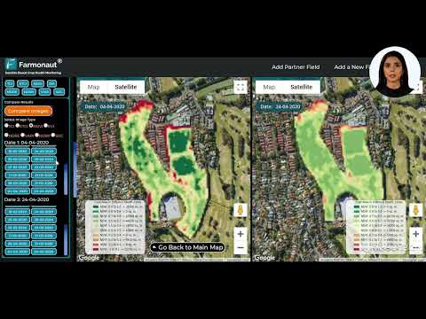
Geospatial analytics forms the backbone of our precision agriculture tools. By combining satellite imagery with advanced data processing techniques, we’re able to create detailed maps that provide valuable insights into field conditions, crop health, and environmental patterns.
Our geospatial analytics capabilities include:
- Field boundary mapping
- Crop type identification
- Yield estimation
- Change detection over time
These tools allow farmers to make data-driven decisions about everything from planting dates to harvest scheduling, ensuring optimal resource utilization and maximizing profitability.
Smart Farming Technologies: Beyond Satellite Imagery
While satellite imagery forms the core of our offerings, we understand that truly smart farming requires a holistic approach. That’s why we’ve integrated a range of complementary technologies into our platform, including:
- IoT sensors for real-time field monitoring
- AI-powered predictive analytics
- Machine learning algorithms for pattern recognition
- Blockchain technology for supply chain traceability
These technologies work in concert with our satellite data to provide a comprehensive view of agricultural operations, from field to market.
The Environmental Impact of Precision Agriculture
As stewards of the land, farmers are increasingly concerned about the environmental impact of their practices. Our precision agriculture tools are designed with sustainability in mind, helping to:
- Reduce water usage through targeted irrigation
- Minimize chemical inputs by identifying areas of need
- Decrease fuel consumption through optimized field operations
- Promote soil health through informed management practices
By providing farmers with the tools to make more precise decisions, we’re not just improving productivity; we’re fostering a more sustainable approach to agriculture that benefits both farmers and the planet.
Comparative Analysis: Traditional vs. Satellite-Based Farming Methods
| Metric | Traditional Farming | Farmonaut’s Satellite-Based Approach |
|---|---|---|
| Crop Monitoring Frequency | Monthly | Daily |
| Field Coverage | Partial | Complete |
| Data Accuracy | Moderate | High |
| Resource Optimization | Limited | Extensive |
| Yield Improvement | Incremental | Significant |
| Environmental Impact | Higher | Lower |
The Future of Farming: Integrating Advanced Technologies
As we look to the future, we see a world where farming becomes increasingly data-driven and technologically sophisticated. Our ongoing research and development efforts are focused on integrating emerging technologies to further enhance our platform’s capabilities. Some areas we’re exploring include:
- Hyperspectral imaging for even more detailed crop analysis
- Advanced machine learning algorithms for pest and disease prediction
- Integration with autonomous farm equipment for precision operations
- Enhanced weather modeling for improved risk management
These advancements will continue to push the boundaries of what’s possible in precision agriculture, driving increased productivity and sustainability across the industry.
Accessing Farmonaut’s Services
We’re committed to making our technology accessible to farmers of all sizes. Whether you’re managing a small family farm or overseeing large-scale agricultural operations, we have solutions tailored to meet your needs. Our services are available through multiple platforms:


Subscription Options
Frequently Asked Questions
Q: How often is satellite imagery updated on the Farmonaut platform?
A: Our platform typically updates satellite imagery on a daily basis, weather permitting. This ensures that farmers have access to the most current data for decision-making.
Q: Can Farmonaut’s technology be used for all types of crops?
A: Yes, our technology is designed to work with a wide variety of crops. The multispectral analysis can be applied to everything from grains and vegetables to fruit orchards and vineyards.
Q: How accurate is the yield prediction feature?
A: Our yield prediction feature has shown high accuracy in field tests, typically within 5-10% of actual yields. However, accuracy can vary depending on factors such as crop type and local conditions.
Q: Is an internet connection required to use Farmonaut’s services?
A: While an internet connection is necessary to receive real-time updates and access our full suite of features, our mobile apps offer some offline functionality for field use.
Q: How does Farmonaut protect farmers’ data privacy?
A: We take data privacy very seriously. All farm data is encrypted and stored securely in the cloud. We adhere to strict privacy policies and never share individual farm data without explicit consent.
Conclusion: Embracing the Future of Agriculture
As we’ve explored throughout this article, the integration of satellite imagery, remote sensing, and cloud-based technologies is revolutionizing the agricultural landscape. At Farmonaut, we’re proud to be at the forefront of this transformation, providing farmers with the tools they need to meet the challenges of modern agriculture.
From our advanced earth observation data processing to our intuitive precision agriculture tools, we’re committed to enhancing agricultural productivity while promoting sustainability. Our cloud-based crop monitoring systems, powered by multispectral imagery analysis and geospatial analytics, are changing the way farmers approach crop management.
As we look to the future, we’re excited about the continued evolution of smart farming technologies. With ongoing advancements in satellite technology, AI, and data processing, the potential for further innovation in agriculture is limitless.
We invite you to join us on this journey towards a more efficient, sustainable, and productive agricultural future. Whether you’re a small-scale farmer or a large agribusiness, Farmonaut’s solutions are designed to help you thrive in the ever-changing world of modern farming.
Together, we can cultivate a future where technology and tradition work hand in hand to feed the world while preserving our planet for generations to come.