
🌿 Introduction to Farmonaut’s Satellite Image Comparison Tool
In the ever-evolving world of agriculture, staying ahead of the curve is crucial for farmers and agricultural professionals. Farmonaut, a cutting-edge agricultural technology company, has developed an innovative solution that allows users to perform side-by-side image comparison of satellite imagery. This powerful tool enables farmers to make data-driven decisions and optimize their farming practices like never before.

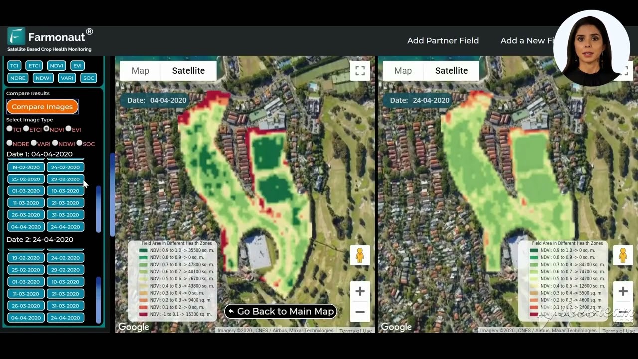
🛰️ How Farmonaut’s Satellite Image Comparison Works
Farmonaut’s satellite image comparison feature is designed with user-friendliness in mind. Here’s a step-by-step guide on how to use this groundbreaking tool:
- Open the Farmonaut app and navigate to the map control section.
- Look for the “Compare Results” option within the interface.
- Select the type of image you want to compare, such as NDVI (Normalized Difference Vegetation Index).
- Choose two dates from the available options for comparison.
- Click on the “Compare Images” button to generate results.

Once you’ve completed these steps, Farmonaut will display two satellite images side by side, allowing you to easily identify changes and trends in your farmland over time.
🌾 Benefits of Side-by-Side Map Comparison
The ability to perform side-by-side map comparison offers numerous advantages for farmers and agricultural professionals:
- Track crop health and growth patterns over time
- Identify areas of concern or potential issues early on
- Optimize resource allocation based on historical data
- Make informed decisions about irrigation, fertilization, and pest control
- Monitor the effectiveness of implemented farming strategies

📊 Leveraging Satellite Image Comparison for Precision Agriculture
Farmonaut’s satellite image comparison tool is a game-changer in the field of precision agriculture. By utilizing this technology, farmers can:
- Analyze NDVI data to assess crop health and vigor
- Detect early signs of stress or disease in crops
- Identify areas of low productivity and implement targeted interventions
- Optimize irrigation schedules based on historical vegetation patterns
- Plan harvest times more accurately by monitoring crop maturity
🔄 Flexibility and Customization
One of the key strengths of Farmonaut’s satellite image comparison feature is its flexibility. Users can easily change dates and generate new comparisons, allowing for dynamic analysis of farm conditions over different time periods. This adaptability ensures that farmers can stay on top of changing conditions and make timely adjustments to their farming strategies.

🌍 Conclusion: Embracing the Future of Farming
Farmonaut’s satellite image comparison tool represents a significant leap forward in agricultural technology. By harnessing the power of satellite imagery and side-by-side comparison, farmers can gain unprecedented insights into their land and crops. This level of data-driven decision-making has the potential to revolutionize farming practices, leading to increased productivity, reduced resource waste, and more sustainable agriculture.
As we face growing challenges in food production and environmental sustainability, tools like Farmonaut’s satellite image comparison will play a crucial role in shaping the future of farming. By embracing this technology, farmers can stay ahead of the curve and ensure the long-term success of their operations.
Frequently Asked Questions
Q: How often are satellite images updated in Farmonaut?
A: The frequency of satellite image updates can vary depending on the specific satellite used and your location. Generally, Farmonaut provides updates every few days to weeks.
Q: Can I compare more than two images at once?
A: Currently, Farmonaut’s side-by-side image comparison feature allows you to compare two images at a time. However, you can easily change dates to make multiple comparisons as needed.
Q: Is Farmonaut’s satellite image comparison available worldwide?
A: Farmonaut’s coverage may vary by region. It’s best to check with their customer support for specific availability in your area.
Q: What types of satellite images can I compare besides NDVI?
A: While NDVI is a popular option, Farmonaut may offer other types of imagery comparisons such as false color composites or soil moisture maps. The available options may depend on your subscription level.
Q: How can I get started with Farmonaut’s satellite image comparison tool?
A: To get started, download the Farmonaut app from your device’s app store, create an account, and follow the steps outlined in this article to begin comparing satellite images of your farmland.


