
Revolutionizing Agriculture: How Satellite Imagery and Precision Farming Are Transforming Crop Health Monitoring
“Satellite-based precision farming can increase crop yields by up to 20% while reducing water usage by 30%”
In the ever-evolving landscape of agriculture, we’re witnessing a remarkable transformation driven by cutting-edge technology. Satellite imagery for agriculture and precision farming techniques are at the forefront of this revolution, reshaping how we monitor crop health, manage resources, and optimize agricultural production. In this comprehensive exploration, we’ll delve into the world of remote sensing in farming and discover how these innovations are changing the face of modern agriculture.
The Power of Satellite Imagery in Agriculture
Satellite technology has come a long way since the launch of the first Landsat satellite in 1972. Today, a constellation of advanced satellites orbits the Earth, capturing high-resolution images that provide invaluable data for farmers and agronomists. These eyes in the sky offer a bird’s-eye view of agricultural landscapes, enabling us to monitor vast areas of farmland with unprecedented accuracy and frequency.

Key advantages of satellite imagery for agriculture include:
- Wide coverage: Satellites can capture images of entire regions, providing a comprehensive view of agricultural areas.
- Regular monitoring: With frequent revisit times, satellites offer up-to-date information on crop health and growth patterns.
- Non-invasive observation: Unlike ground-based methods, satellite imagery doesn’t disturb crops or soil.
- Historical data: Archives of satellite images allow for long-term trend analysis and comparison.
Precision Agriculture Technology: A Game-Changer for Farmers
Precision agriculture technology harnesses the power of satellite imagery, combining it with other data sources to create a holistic approach to farm management. This innovative methodology allows farmers to make informed decisions based on accurate, real-time information about their fields.
Some key components of precision agriculture include:
- Multispectral imaging: Satellites equipped with multispectral sensors capture data across various wavelengths, revealing information invisible to the naked eye.
- Vegetation index analysis: Indices like NDVI (Normalized Difference Vegetation Index) help assess crop health and vigor.
- Crop yield prediction: Advanced algorithms use satellite data to forecast harvest outcomes with increasing accuracy.
- Smart farming solutions: Integrated systems that combine satellite data with on-ground sensors and machinery for optimized farming operations.
Remote Sensing in Farming: Unlocking New Possibilities
Remote sensing technologies have revolutionized our ability to monitor and manage agricultural lands. By leveraging data from satellites, drones, and other aerial platforms, we can gain insights into crop health, soil conditions, and environmental factors that influence agricultural productivity.

Benefits of remote sensing in agriculture include:
- Early detection of crop stress: Multispectral imaging can identify issues like pest infestations or nutrient deficiencies before they become visible to the human eye.
- Precision irrigation management: Satellite-based data on soil moisture and crop water stress enables targeted irrigation strategies.
- Crop classification and mapping: Remote sensing facilitates accurate identification and mapping of different crop types across large areas.
- Environmental monitoring: Satellites help track changes in land use, deforestation, and the impact of climate change on agricultural regions.
Crop Health Monitoring: A New Era of Precision
One of the most significant applications of satellite technology in agriculture is crop health monitoring. By analyzing multispectral images, we can assess various aspects of plant health and growth, enabling timely interventions and optimized crop management.
“Multispectral imaging from satellites can detect crop stress up to 2 weeks earlier than visual inspection by farmers.”
Key aspects of satellite-based crop health monitoring include:
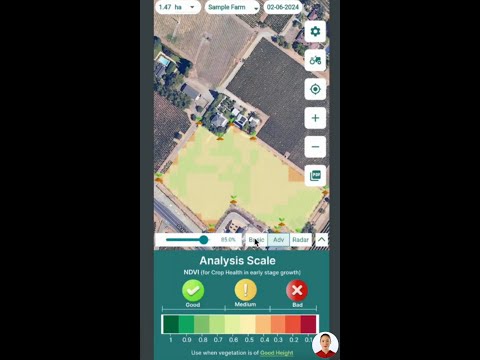
- Vegetation indices: Metrics like NDVI, EVI (Enhanced Vegetation Index), and SAVI (Soil Adjusted Vegetation Index) provide quantitative measures of crop health and biomass.
- Chlorophyll content assessment: Spectral bands sensitive to chlorophyll help evaluate plant nutritional status.
- Stress detection: Early identification of water stress, nutrient deficiencies, or disease outbreaks allows for prompt corrective actions.
- Growth stage monitoring: Tracking crop phenology helps optimize the timing of agricultural operations.
Agricultural Land Mapping: Precision from Space
Satellite imagery has transformed the way we map and analyze agricultural lands. High-resolution images, combined with advanced geospatial technologies, enable precise mapping of field boundaries, crop types, and land use patterns.

Applications of agricultural land mapping include:
- Crop inventory: Accurate assessment of planted areas for different crops at regional or national scales.
- Land use planning: Informed decision-making for sustainable agricultural development and conservation efforts.
- Yield estimation: Combining land use maps with crop health data for improved yield forecasting.
- Disaster assessment: Rapid mapping of areas affected by floods, droughts, or other natural disasters.
Vegetation Index Analysis: The Key to Understanding Crop Health
Vegetation indices derived from satellite imagery provide valuable insights into crop health, vigor, and productivity. These mathematical combinations of spectral bands highlight specific plant characteristics, making it easier to assess large areas quickly and accurately.
Popular vegetation indices used in agriculture include:
- NDVI (Normalized Difference Vegetation Index): A widely used index that correlates with photosynthetic activity and biomass.
- EVI (Enhanced Vegetation Index): An improved version of NDVI that performs better in areas with dense vegetation.
- NDRE (Normalized Difference Red Edge): Particularly useful for assessing nitrogen content in crops.
- LAI (Leaf Area Index): Estimates the total leaf area per unit ground surface area, indicating crop development and potential yield.
Multispectral Imaging in Agriculture: Seeing Beyond the Visible
Multispectral imaging is a cornerstone of satellite-based agriculture monitoring. By capturing data across multiple spectral bands, including visible light and near-infrared, these sensors reveal information about crops that would otherwise be invisible to the human eye.
Key applications of multispectral imaging in agriculture include:
- Crop stress detection: Identifying areas of water stress, nutrient deficiencies, or pest infestations before visible symptoms appear.
- Yield prediction: Correlating spectral signatures with potential crop yields.
- Soil health assessment: Analyzing soil properties and organic matter content.
- Precision fertilizer application: Creating variable-rate application maps based on plant nutrient status.
Precision Farming Techniques: Optimizing Agricultural Practices
Precision farming leverages satellite data and other technologies to optimize every aspect of agricultural production. By tailoring management practices to the specific needs of each field or even individual plants, farmers can maximize yields while minimizing resource use and environmental impact.
Key precision farming techniques include:
- Variable rate technology (VRT): Adjusting the application of inputs like fertilizers, pesticides, and water based on spatial variability within fields.
- Site-specific crop management: Tailoring planting, irrigation, and harvesting strategies to local conditions.
- Precision livestock farming: Using satellite data and GPS for pasture management and animal tracking.
- Automated guidance systems: Improving the efficiency and accuracy of farm machinery operations.
Agricultural Data Analytics: Turning Insights into Action
The wealth of data generated by satellites and other precision farming technologies requires sophisticated analytics to transform raw information into actionable insights. Agricultural data analytics combines satellite imagery, weather data, soil information, and historical yield data to provide farmers with powerful decision-support tools.
Key aspects of agricultural data analytics include:
- Predictive modeling: Forecasting crop yields, disease outbreaks, and market trends.
- Machine learning algorithms: Automating the interpretation of satellite imagery and sensor data.
- Big data integration: Combining multiple data sources for comprehensive farm management insights.
- Decision support systems: Providing farmers with timely recommendations for optimal crop management.
Satellite Weather Monitoring: Enhancing Agricultural Decision-Making
Accurate weather information is crucial for successful farming, and satellite-based weather monitoring has significantly improved our ability to forecast and track weather patterns. This technology provides farmers with valuable data for planning agricultural activities and mitigating weather-related risks.
Benefits of satellite weather monitoring for agriculture include:
- Improved rainfall estimates: Satellite-based precipitation measurements enhance irrigation planning and drought monitoring.
- Temperature and humidity tracking: Vital information for assessing crop stress and disease risk.
- Severe weather warnings: Early alerts for events like hailstorms or frost allow farmers to take protective measures.
- Climate change analysis: Long-term satellite data helps in understanding and adapting to changing climate patterns.
Smart Farming Solutions: Integrating Satellite Data with On-Ground Technologies
Smart farming solutions combine satellite-derived insights with IoT (Internet of Things) devices, sensors, and farm management software to create comprehensive agricultural management systems. These integrated approaches enable farmers to make data-driven decisions across all aspects of their operations.

Components of smart farming solutions include:
- Farm management software: Centralized platforms for data analysis, planning, and record-keeping.
- IoT sensors: On-ground devices that collect real-time data on soil moisture, temperature, and other parameters.
- Automated irrigation systems: Combining satellite and sensor data for precise water management.
- Drone integration: Using UAVs for high-resolution imaging and targeted treatments.
Agritech Innovations: The Future of Farming
The agricultural technology sector is continuously evolving, with new innovations emerging to address the challenges of modern farming. These agritech solutions often leverage satellite data as a foundation for advanced applications.
Emerging agritech innovations include:
- AI-powered crop monitoring: Advanced algorithms that can detect and diagnose crop issues with high accuracy.
- Blockchain for traceability: Ensuring transparency and security in agricultural supply chains.
- Vertical farming systems: Integrating satellite data for optimized indoor crop production.
- Robotic farming: Autonomous machines guided by satellite positioning for planting, weeding, and harvesting.
Digital Agriculture Tools: Empowering Farmers with Technology
Digital agriculture tools put the power of satellite technology and data analytics directly into the hands of farmers. These user-friendly applications and platforms make it easier for agricultural professionals to access and utilize advanced technologies in their daily operations.
Examples of digital agriculture tools include:
- Mobile apps for crop monitoring: Allowing farmers to access satellite-derived insights on their smartphones.
- Web-based mapping platforms: Providing easy access to agricultural land maps and vegetation indices.
- Decision support systems: Offering recommendations based on satellite data and local conditions.
- Farm management software: Integrating satellite data with other farm records for comprehensive management.
Satellite-Based Irrigation Management: Optimizing Water Use
Water scarcity is a growing concern in many agricultural regions, making efficient irrigation management crucial. Satellite-based technologies offer innovative solutions for optimizing water use in agriculture.
Benefits of satellite-based irrigation management include:
- Precise soil moisture mapping: Identifying areas that require irrigation with high spatial accuracy.
- Evapotranspiration monitoring: Estimating crop water requirements based on satellite-derived data.
- Irrigation scheduling: Optimizing the timing and amount of water application for different crops and field zones.
- Water stress detection: Early identification of areas where crops are experiencing water deficits.
Agricultural Disaster Assessment: Rapid Response and Recovery
When natural disasters strike agricultural areas, satellite imagery provides a rapid and comprehensive way to assess the damage and plan recovery efforts. This technology is invaluable for both immediate response and long-term resilience planning.
Applications of satellite imagery in agricultural disaster assessment include:
- Flood mapping: Quickly identifying inundated agricultural lands and assessing crop losses.
- Drought monitoring: Tracking the extent and severity of drought conditions over large areas.
- Storm damage assessment: Evaluating the impact of hurricanes, hailstorms, and other severe weather events on crops.
- Wildfire monitoring: Mapping burned areas and assessing the impact on agricultural and forestry resources.
Sustainable Farming Practices: Leveraging Satellite Data for Environmental Stewardship
Satellite technology plays a crucial role in promoting and monitoring sustainable farming practices. By providing accurate data on land use, crop health, and environmental conditions, satellites help farmers make decisions that balance productivity with environmental conservation.
Ways satellite data supports sustainable farming include:
- Precision agriculture: Minimizing inputs and reducing environmental impact through targeted applications.
- Conservation monitoring: Tracking the effectiveness of soil conservation measures and habitat preservation efforts.
- Carbon sequestration assessment: Estimating the carbon storage potential of agricultural lands and forests.
- Biodiversity mapping: Identifying and protecting areas of high ecological value within agricultural landscapes.
Geospatial Technology in Agriculture: Beyond Satellite Imagery
While satellite imagery is a cornerstone of modern precision agriculture, it’s part of a broader ecosystem of geospatial technologies that are transforming farming. These complementary technologies enhance the value and applicability of satellite data in agricultural settings.
Key geospatial technologies in agriculture include:
- GPS guidance systems: Improving the accuracy of planting, spraying, and harvesting operations.
- GIS (Geographic Information Systems): Integrating multiple layers of spatial data for comprehensive farm management.
- LiDAR (Light Detection and Ranging): Creating high-resolution 3D maps of agricultural landscapes.
- Remote sensing drones: Providing on-demand, high-resolution imagery to complement satellite data.
Comparing Traditional Farming vs. Satellite-Based Precision Farming
To better understand the impact of satellite technology on agriculture, let’s compare traditional farming methods with modern precision farming approaches:
| Agricultural Aspect | Traditional Farming | Satellite-Based Precision Farming |
|---|---|---|
| Crop Health Monitoring | Visual inspection, time-consuming and subjective | Multispectral imaging, early detection of issues, objective data |
| Irrigation Management | Uniform application, potential over or under-watering | Variable rate irrigation based on precise soil moisture data |
| Pest Detection | Manual scouting, reactive approach | Early detection through spectral analysis, proactive management |
| Yield Prediction | Based on historical data and farmer experience | Advanced modeling using real-time crop health data |
| Resource Efficiency | Uniform application of inputs across fields | Targeted application, reducing waste and environmental impact |
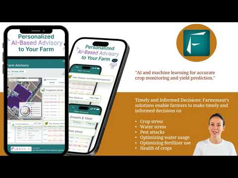
The Role of Farmonaut in Revolutionizing Agriculture
In the landscape of agricultural technology companies, Farmonaut stands out as a pioneer in making precision agriculture accessible and affordable. By leveraging advanced satellite technology and artificial intelligence, Farmonaut provides farmers with powerful tools for crop monitoring, resource management, and decision-making.
Key features of Farmonaut’s platform include:
- Satellite-based crop health monitoring: Utilizing multispectral imagery to provide real-time insights into vegetation health, soil moisture, and other critical metrics.
- AI-powered advisory system: The Jeevn AI system offers personalized recommendations based on satellite data and other inputs.
- Blockchain-based traceability: Ensuring transparency and security in agricultural supply chains.
- Resource management tools: Optimizing the use of water, fertilizers, and other inputs through data-driven insights.
Farmonaut’s commitment to making precision agriculture technology accessible to farmers of all scales is helping to drive the broader adoption of these transformative tools across the agricultural sector.
FAQs: Satellite Imagery and Precision Farming
- How often are satellite images updated for agricultural monitoring?
Satellite revisit times vary, but many modern systems provide updates every few days, with some offering daily imagery for certain areas. - Can satellite imagery detect specific crop diseases?
While satellites can’t directly identify diseases, they can detect stress patterns that may indicate disease presence, prompting further investigation. - How accurate are yield predictions based on satellite data?
Accuracy varies, but advanced models combining satellite imagery with other data sources can achieve predictions within 5-10% of actual yields in many cases. - Is satellite-based precision farming cost-effective for small farms?
Yes, companies like Farmonaut are making these technologies increasingly affordable and accessible to farms of all sizes. - How does cloud cover affect satellite imagery for agriculture?
Cloud cover can obstruct optical satellite imagery, but radar satellites and frequent revisits help mitigate this issue.
Conclusion: Embracing the Future of Agriculture
As we’ve explored throughout this article, satellite imagery and precision farming technologies are revolutionizing agriculture in profound ways. From enhancing crop health monitoring to optimizing resource use and promoting sustainable practices, these innovations are helping farmers meet the challenges of feeding a growing global population while minimizing environmental impact.
The integration of satellite data with other advanced technologies like AI, IoT, and blockchain is opening up new possibilities for smart, data-driven farming. Companies like Farmonaut are at the forefront of this agricultural revolution, making these powerful tools accessible to farmers around the world.
As we look to the future, it’s clear that satellite-based precision farming will play an increasingly vital role in shaping sustainable, efficient, and productive agricultural practices. By embracing these technologies, we can work towards a future where farming is not only more productive but also more in harmony with our planet’s ecosystems.
To learn more about how you can leverage satellite technology for your agricultural operations, explore Farmonaut’s solutions:


For developers interested in integrating satellite data into their own applications, check out Farmonaut’s API and API Developer Docs.
By harnessing the power of satellite technology and precision farming, we can cultivate a more sustainable and productive future for agriculture worldwide.


