

armonautTM
Satellite Imagery
Social Feeds
[instagram-feed]
[WD_FB id="1"]
[custom-twitter-feeds]
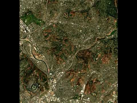
Satellite Imagery At Your FingerTips
Latest as well as historical imagery available ranging from visible to non-visible spectrum.
Provides access to 13 different visible and non-visible bands.

Select Image Bands, Map Field and Time Interval
STEP 1

Select Days To Retrieve and Make Payment
STEP 2

Receive Imagery On Your Email ID
STEP 3
Satellite Imagery Catalog

B1: Coastal Aerosol, CW: 0.443 um, Resolution: 60 m

B2: Blue, CW: 0.490 um, Resolution: 10 m

B3: Green, CW: 0.560 um, Resolution: 10 m

B4: Red, CW: 0.665 um, Resolution: 10 m

B5: Vegetation Red Edge, CW: 0.705 um, Resolution: 20 m

B6: Vegetation Red Edge, CW: 0.740 um, Resolution: 20 m

B7: Vegetation Red Edge, CW: 0.783 um, Resolution: 20 m

B8: NIR, CW: 0.842 um, Resolution: 10 m

B8A: Vegetation Red Edge, CW: 0.865 um, Resolution: 20 m

B9: Water Vapour, CW: 0.945 um, Resolution: 60 m

B10: SWIR – Cirrus, CW: 1.375 um, Resolution: 60 m

B11: SWIR, CW: 0.443 um, Resolution: 20 m

B12: SWIR, CW: 2.190 um, Resolution: 20 m

TCI: True Color Image, Resolution: 10 m

ETCI: Enhanced True Color Image, Resolution: 10 m

NDVI: Normalized Difference Vegetation Index, Resolution: 10 m

MNDVI: Masked Normalized Difference Vegetation Index, Resolution: 10 m

NDWI: Normalized Difference Water Index, Resolution: 10 m

MNDWI: Masked Normalized Difference Water Index, Resolution: 10 m

CIR: Color Infrared Image, Resolution: 10 m
Latest Imagery Available Every 2-5 Days
The constellation of satellites revolve in tandem and map every location on earth every 2-5 days.

Cauvery Delta, TamilNadu
17-Nov-2018

North Sentinel Island, Andaman
2-Nov-2018

Palm Island, Dubai
11-Oct-2018

Zaanse Schans, Amsterdam
17-Nov-2018
Create Stunning Time Lapses
Use the imagery downloaded through our system to create time lapse.
Time Lapses can reveal geological changes with time, which can used for various analyses.
Monitor Crop Health
Farmonaut generates crop health map by analyzing visible as well as non-visible spectrum imagery.
Select Images To Retrieve
*From:
*To:

Tutorial
Add Balance
RAW IMAGES
B1: Coastal Aerosol, CW: 0.443 um, Resolution: 60 mB2: Blue, CW: 0.490 um, Resolution: 10 m
B3: Green, CW: 0.560 um, Resolution: 10 m
B4: Red, CW: 0.665 um, Resolution: 10 m
B5: Vegetation Red Edge, CW: 0.705 um, Resolution: 20 m
B6: Vegetation Red Edge, CW: 0.740 um, Resolution: 20 m
B7: Vegetation Red Edge, CW: 0.783 um, Resolution: 20 m
B8: NIR, CW: 0.842 um, Resolution: 10 m
B8A: Vegetation Red Edge, CW: 0.865 um, Resolution: 20 m
B9: Water Vapour, CW: 0.945 um, Resolution: 60 m
B10: SWIR - Cirrus, CW: 1.375 um, Resolution: 60 m
B11: SWIR, CW: 0.443 um, Resolution: 20 m
B12: SWIR, CW: 2.190 um, Resolution: 20 m
PROCESSED IMAGES
TCI: True Color Image, Resolution: 10 mETCI: Enhanced True Color Image, Resolution: 10 m
NDVI: Normalized Difference Vegetation Index, Resolution: 10 m
MNDVI: Masked Normalized Difference Vegetation Index, Resolution: 10 m
NDWI: Normalized Difference Water Index, Resolution: 10 m
MNDWI: Masked Normalized Difference Water Index, Resolution: 10 m
CIR: Color Infrared Image, Resolution: 10 m
Imagery Is Available For These Dates
Summary
Cost/Hectare: Raw Image
Retrieving...
Cost/Hectare: Processed Image
Retrieving...
Area Of The Field (in Hectares)
Retrieving...
Total Area (in Hectares)
Calculating...
Number Of Days Selected
Retrieving...
Number of Raw Images
Retrieving...
Number of Processed Images
Retrieving...
Estimated Delivery Time (in Minutes)
Calculating...
*Note: Minimum Area for billing is 100 Hectares. Hence, any selected area of less than 100 hectares is rounded off to 100 hectares.
Use A Different Email Address
Your Farmonaut Balance
Retrieving...
Payment Of This Order
Calculating...
(Total Payment - Balance)
Calculating...
Your Imagery Order is Placed!
You can place 2 delivery orders at once per user. More orders can be placed as soon as you receive results of your previous order. Farmonaut does this to optimize resource sharing.


support@farmonaut.com