Henderson County Denies Commercial Rezoning: Preserving Rural Character Amidst Development Pressures
“Henderson County denied rezoning of 35 acres from residential to commercial, preserving rural character against development pressures.”
In the picturesque landscapes of Henderson County, North Carolina, a significant decision has been made that underscores the delicate balance between rural preservation and commercial development. We at Farmonaut, as experts in agricultural technology and land use monitoring, recognize the importance of such decisions in shaping the future of rural communities. Today, we delve into the recent rezoning decisions made by Henderson County commissioners, exploring their implications for local residents, businesses, and the overall character of this beautiful region.
The Pivotal Decision: Preserving Rural Character
On February 3, Henderson County commissioners made a unanimous decision that resonated with many local residents. They denied a proposal to rezone nearly 35 acres of land off Haywood Road from estate residential to local commercial. This decision was met with applause from residents who had voiced strong opposition to the potential development.
The application, put forth by Mills River LLC and represented by Grant James, faced scrutiny not only from the commissioners but also from the Planning Board. In December, the Planning Board had voted 7-1 against recommending the rezoning, setting the stage for the final decision.

Understanding the Rezoning Request
The land in question, located on Grandview Lane near South Rugby Road and close to the Mills River border, is primarily surrounded by residential and agricultural properties. While there are some areas allocated for commercial use in the vicinity, the predominant character of the area remains rural and residential.
This rezoning request highlights a common challenge faced by many rural communities across the United States. As urban areas expand and development pressures increase, counties like Henderson must carefully navigate the transition from rural to commercial zoning, balancing economic opportunities with the preservation of community character.
Community Concerns and Public Hearing
During the public hearing that preceded the vote, six residents stepped forward to share their concerns about the potential implications of commercial zoning in their neighborhood. Their testimonies painted a vivid picture of the community’s attachment to its rural lifestyle and the fears associated with rapid development.
- Traffic Concerns: A primary issue raised by residents was the anticipated increase in traffic. Many voiced apprehensions about the future widening of Haywood Road/N.C. 191 and how commercial development would exacerbate congestion in the area.
- Preservation of Rural Character: Residents expressed deep-rooted connections to the rural environment, emphasizing that the introduction of commercial establishments would undermine the community character and lifestyle they chose when moving to the area.
- Environmental Considerations: The proximity of the site to a conservation area, farmland, and a cemetery was highlighted as a reason for additional scrutiny and consideration.
- Lack of Specificity: Questions arose about the lack of specificity in the application regarding the nature of potential developments on the property, as applicants are not obliged to outline what businesses may occupy the site.
One local resident expressed particular concern over how the combination of tree removal for road improvements and potential new commercial rezoning might transform the area into a high-traffic zone akin to Airport Road or Four Seasons Boulevard, areas known for their commercial development and associated congestion.
Aligning with the Comprehensive Plan
The primary reason cited for the denial of the rezoning request was its conflict with the county’s Comprehensive Plan. This plan prioritizes maintaining the area’s residential character, reflecting a long-term vision for the community’s development.
Comprehensive plans are crucial tools in guiding the growth and development of communities. They typically outline goals, policies, and strategies for land use, transportation, housing, economic development, and environmental protection. By adhering to these plans, counties like Henderson can ensure that development decisions are made in a systematic and consistent manner, reflecting the community’s values and long-term aspirations.

A Contrasting Decision: Approving Residential Rezoning
“A separate 6.65-acre rezoning from commercial to residential was approved, supporting diversification of housing options in Henderson County.”
In a separate but related decision, the commissioners unanimously approved a rezoning request for a 6.65-acre parcel located on Shafer Road, off Continental Divide Drive and Melton Pond Lane. This request sought to change the zoning from regional commercial to residential district II rural.
Unlike the previous hearing, no residents spoke out against this request. This approval aligned with the Planning Board’s earlier unanimous recommendation in January, noting that the rezoning was consistent with the county’s Comprehensive Plan aimed at diversifying housing options in the area.
This decision illustrates the nuanced approach taken by the county in managing land use. While preserving rural character is a priority, the county also recognizes the need for diverse housing options to accommodate changing demographics and housing needs.
Comparative Analysis of Rezoning Decisions
| Rezoning Request | Original Zoning | Proposed Zoning | Acreage | Decision | Key Considerations |
|---|---|---|---|---|---|
| Haywood Road Parcel | Estate Residential | Local Commercial | 35 acres | Denied |
– Conflict with Comprehensive Plan – Traffic concerns – Preservation of rural character – Proximity to conservation areas |
| Shafer Road Parcel | Regional Commercial | Residential District II Rural | 6.65 acres | Approved |
– Alignment with Comprehensive Plan – Diversification of housing options – No public opposition – Consistent with surrounding area |
Implications for Rural Land Use and Development
The contrasting outcomes of these rezoning requests highlight several important aspects of rural land use planning and development:
- Balancing Growth and Preservation: Rural communities face the challenge of accommodating growth while preserving their unique character. The decisions made by Henderson County demonstrate a commitment to maintaining this balance.
- Community Engagement: The active participation of residents in the rezoning process underscores the importance of community involvement in land use decisions.
- Comprehensive Planning: Adherence to a well-crafted comprehensive plan provides a framework for consistent decision-making that reflects long-term community goals.
- Traffic and Infrastructure Considerations: The impact of zoning changes on local infrastructure, particularly traffic, is a crucial factor in rural development decisions.
- Environmental Conservation: The proximity to conservation areas and farmland plays a significant role in zoning decisions, reflecting a growing awareness of environmental preservation.
The Role of Technology in Land Use Planning
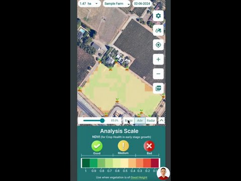
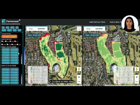
As experts in agricultural technology, we at Farmonaut recognize the vital role that advanced technologies can play in informed land use planning and decision-making. Our satellite-based solutions offer valuable insights for both agricultural and urban planning purposes.
For instance, our satellite imagery and AI-powered analysis can provide detailed information on land use patterns, vegetation health, and soil conditions. This data can be invaluable for county planners and decision-makers when assessing the potential impact of zoning changes on local ecosystems and agricultural productivity.

Our API and API Developer Docs provide access to this wealth of data, enabling integration into existing planning tools and workflows.
Leveraging Satellite Technology for Rural Development
Satellite technology, such as that employed by Farmonaut, can play a crucial role in supporting informed decision-making in rural development contexts. Here’s how:
- Land Use Mapping: High-resolution satellite imagery can provide up-to-date maps of current land use, helping planners identify areas suitable for different types of development.
- Environmental Impact Assessment: By analyzing vegetation indices and land cover changes over time, satellite data can help predict the potential environmental impact of proposed developments.
- Agricultural Productivity Analysis: For areas with significant agricultural activity, satellite-based crop health monitoring can inform decisions about preserving high-value farmland.
- Infrastructure Planning: Satellite imagery can assist in planning road networks and other infrastructure to minimize disruption to existing communities and natural habitats.

The Future of Rural Development in Henderson County
As Henderson County continues to navigate the complexities of rural development, several key factors will likely shape future decisions:
- Smart Growth Strategies: Implementing smart growth principles that encourage development in areas with existing infrastructure while preserving open spaces and rural character.
- Sustainable Agriculture: Promoting sustainable agricultural practices that maintain the economic viability of farming while preserving rural landscapes.
- Mixed-Use Development: Exploring opportunities for mixed-use developments that can provide commercial services without significantly altering the rural character of an area.
- Transportation Planning: Developing comprehensive transportation plans that address increased traffic concerns while maintaining the rural feel of county roads.
- Conservation Easements: Encouraging the use of conservation easements to permanently protect valuable natural and agricultural lands from development.
Technological Solutions for Rural Land Management
At Farmonaut, we’re committed to providing cutting-edge solutions that can aid in effective rural land management. Our suite of tools can be particularly valuable for county planners, agricultural extension services, and individual landowners:
- Crop Health Monitoring: Our satellite-based crop health monitoring system can help identify areas of high agricultural productivity, informing decisions about land preservation.
- Soil Moisture Analysis: By providing insights into soil moisture levels, we can help planners identify areas prone to flooding or drought, crucial information for zoning decisions.
- Land Use Change Detection: Our advanced algorithms can detect and quantify changes in land use over time, providing valuable data for long-term planning and policy-making.


Community Engagement and Participatory Planning
The Henderson County rezoning decisions highlight the importance of community engagement in the planning process. Moving forward, we can expect to see increased emphasis on participatory planning techniques that involve residents in shaping the future of their communities. This might include:
- Digital Platforms: Utilizing online platforms to gather community input on proposed zoning changes and development projects.
- Visualization Tools: Employing 3D visualization tools to help residents better understand the potential impact of proposed developments.
- Community Workshops: Organizing interactive workshops where residents can participate in scenario planning exercises.
- Citizen Science Initiatives: Engaging community members in data collection efforts to monitor local environmental conditions and land use changes.
Balancing Economic Development and Rural Preservation
One of the ongoing challenges for rural counties like Henderson is striking a balance between economic development and rural preservation. While commercial development can bring jobs and increased tax revenue, it must be carefully managed to avoid eroding the very qualities that make rural areas attractive. Some strategies to achieve this balance include:
- Cluster Development: Encouraging commercial and residential development in designated clusters to preserve large tracts of open space.
- Agritourism: Promoting agritourism initiatives that can provide economic opportunities while maintaining agricultural land use.
- Green Business Incentives: Offering incentives for businesses that align with rural character and sustainable practices.
- Transfer of Development Rights (TDR) Programs: Implementing TDR programs that allow landowners to sell development rights from areas targeted for preservation to areas designated for growth.
The Role of Data in Informed Decision-Making
As we’ve seen in the Henderson County case, informed decision-making is crucial in land use planning. This is where data-driven approaches, supported by technologies like those offered by Farmonaut, can play a pivotal role:
- Historical Land Use Analysis: By analyzing historical satellite imagery, planners can understand long-term trends in land use and development patterns.
- Predictive Modeling: Advanced AI algorithms can help predict the potential impacts of different zoning scenarios on factors like traffic flow, environmental health, and agricultural productivity.
- Real-Time Monitoring: Continuous satellite monitoring can provide up-to-date information on land use changes, allowing for rapid response to unauthorized development or environmental degradation.
Earn With Farmonaut: Earn 20% recurring commission with Farmonaut’s affiliate program by sharing your promo code and helping farmers save 10%. Onboard 10 Elite farmers monthly to earn a minimum of $148,000 annually—start now and grow your income!
Looking Ahead: The Future of Rural Zoning and Development
As we look to the future, it’s clear that rural communities like Henderson County will continue to face complex decisions regarding zoning and development. The key to success will lie in:
- Adaptive Planning: Developing flexible zoning regulations that can adapt to changing economic and demographic conditions while maintaining core community values.
- Integrated Approach: Taking an integrated approach to planning that considers economic, environmental, and social factors in decision-making.
- Technology Adoption: Embracing new technologies, like those offered by Farmonaut, to support data-driven decision-making in land use planning.
- Continuous Community Engagement: Maintaining ongoing dialogue with residents to ensure that development decisions reflect community aspirations and concerns.

Conclusion: Preserving Rural Character in a Changing World
The recent zoning decisions in Henderson County serve as a microcosm of the challenges faced by rural communities across the United States. By carefully balancing development pressures with the desire to preserve rural character, counties like Henderson are charting a course for sustainable growth that respects community values and environmental considerations.
As we move forward, the integration of advanced technologies, community engagement, and adaptive planning strategies will be crucial in navigating the complex landscape of rural development. At Farmonaut, we’re committed to providing the tools and insights needed to support informed decision-making in land use planning, helping communities like Henderson County preserve their unique character while embracing the opportunities of the future.
Farmonaut Subscriptions
Frequently Asked Questions
Q: What factors led to the denial of the 35-acre commercial rezoning request in Henderson County?
A: The primary factors were:
- Conflict with the county’s Comprehensive Plan, which prioritizes maintaining the area’s residential character
- Strong opposition from local residents
- Concerns about increased traffic and its impact on rural lifestyle
- Proximity to conservation areas, farmland, and a cemetery
Q: How does satellite technology, like that used by Farmonaut, contribute to land use planning?
A: Satellite technology contributes to land use planning by:
- Providing up-to-date land use maps
- Offering insights into vegetation health and soil conditions
- Enabling historical analysis of land use changes
- Supporting environmental impact assessments
- Assisting in infrastructure planning
Q: What strategies can rural communities employ to balance economic development with preservation of rural character?
A: Some strategies include:
- Implementing smart growth principles
- Promoting sustainable agriculture
- Exploring mixed-use developments
- Developing comprehensive transportation plans
- Encouraging the use of conservation easements
- Adopting cluster development approaches
- Promoting agritourism initiatives
Q: How can community engagement be enhanced in the rezoning process?
A: Community engagement can be enhanced through:
- Utilizing digital platforms for gathering input
- Employing 3D visualization tools to illustrate proposed changes
- Organizing interactive community workshops
- Implementing citizen science initiatives
- Maintaining ongoing dialogue with residents throughout the planning process
Q: What role does the county’s Comprehensive Plan play in rezoning decisions?
A: The Comprehensive Plan:
- Serves as a guideline for long-term community development
- Provides a framework for consistent decision-making
- Reflects community values and long-term aspirations
- Helps balance various factors such as housing, economic development, and environmental protection
- Is used as a key reference point in evaluating rezoning requests