
Revolutionizing Agriculture: How Satellite Farming and AI Are Transforming Crop Health Monitoring

“Satellite farming utilizes at least 4 key technologies: NDVI, AI, spectral analysis, and vegetation index analysis for crop monitoring.”
Welcome to the future of agriculture! In this comprehensive guide, we’ll explore how satellite farming and precision agriculture are revolutionizing the way we monitor and manage crops. As we delve into the world of remote sensing in agriculture, we’ll uncover how advanced technologies like NDVI and artificial intelligence are enhancing farm productivity and sustainability.
The Rise of Satellite Farming and Precision Agriculture
In recent years, the agricultural sector has witnessed a remarkable transformation, thanks to the integration of satellite technology and artificial intelligence. This fusion has given birth to what we now call satellite farming or precision agriculture. But what exactly does this mean for farmers and the future of food production?
- Real-time crop monitoring from space
- Data-driven decision making
- Optimized resource management
- Enhanced sustainability practices
At the heart of this revolution is the use of remote sensing in agriculture. Satellites orbiting the Earth capture high-resolution images of farmlands, providing invaluable data that was previously unattainable. This bird’s-eye view allows farmers to gain unprecedented insights into their fields, crop health, and environmental conditions.
NDVI: The Game-Changer in Crop Monitoring
One of the most powerful tools in the satellite farming arsenal is the Normalized Difference Vegetation Index (NDVI). This revolutionary index has become the cornerstone of vegetation index analysis in agriculture.
NDVI in crop monitoring works by measuring the difference between near-infrared light (which healthy vegetation strongly reflects) and red light (which vegetation absorbs). The resulting values provide a clear indication of plant health and vigor.
- NDVI values range from -1 to +1
- Higher values indicate healthier vegetation
- Lower values may signal stress or poor crop health
By leveraging NDVI data, farmers can:
- Identify areas of crop stress early
- Optimize irrigation and fertilization
- Monitor crop growth stages
- Predict yields more accurately
Artificial Intelligence: The Brain Behind Smart Farming
Artificial intelligence in farming is not just a buzzword; it’s a reality that’s transforming agricultural practices. AI algorithms analyze vast amounts of satellite data, weather information, and historical farm records to provide actionable insights.
Here’s how AI is making a difference:
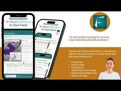
- Crop health monitoring: AI can detect subtle changes in crop appearance that might be invisible to the human eye.
- Pest and disease detection: Machine learning models can identify the early signs of pest infestations or disease outbreaks.
- Yield prediction: AI algorithms can forecast crop yields with increasing accuracy, helping farmers plan harvests and manage resources.
- Smart irrigation: AI-powered systems optimize water usage by analyzing soil moisture, weather forecasts, and crop water requirements.

Vegetation Index Analysis: Beyond NDVI
While NDVI is a powerful tool, it’s not the only vegetation index used in modern agriculture. Other indices provide complementary information, allowing for a more comprehensive understanding of crop health and field conditions.
- Green Chlorophyll Index (GCI): Measures chlorophyll content in leaves
- Normalized Difference Water Index (NDWI): Assesses water content in vegetation
- Leaf Area Index (LAI): Estimates the total leaf area relative to ground area
These indices, when used in combination, provide a holistic view of crop health, allowing farmers to make more informed decisions about their fields.
Water Stress Detection: Ensuring Optimal Hydration
Water stress detection in crops is crucial for maintaining optimal plant health and maximizing yields. Satellite imagery and spectral analysis enable farmers to identify areas of water stress before visible symptoms appear.
Benefits of early water stress detection include:
- Improved irrigation efficiency
- Reduced water waste
- Prevention of crop yield losses
- Enhanced drought resilience
By combining water stress data with AI-powered irrigation systems, farmers can ensure their crops receive the right amount of water at the right time, leading to significant improvements in water use efficiency and crop productivity.

Satellite Imagery for Agriculture: A New Perspective
Satellite imagery for agriculture provides farmers with a wealth of information that was previously unattainable. These high-resolution images offer insights into:
- Crop health and vigor
- Soil moisture levels
- Pest and disease outbreaks
- Field variability
- Crop growth stages
The power of satellite imagery lies in its ability to cover vast areas quickly and repeatedly, allowing for continuous monitoring throughout the growing season. This temporal data is invaluable for tracking changes over time and making informed management decisions.
“Precision agriculture employs 3 main data-driven strategies: water stress detection, pest/disease identification, and crop yield prediction.”
Farm Data Analytics: Turning Information into Action
Farm data analytics is the process of transforming raw satellite data and other agricultural information into actionable insights. This involves:
- Data collection from multiple sources (satellites, weather stations, IoT devices)
- Data processing and cleaning
- Advanced analysis using AI and machine learning
- Visualization of results for easy interpretation
- Generation of actionable recommendations
By leveraging farm data analytics, farmers can make data-driven decisions that optimize resource use, reduce costs, and improve overall farm performance.
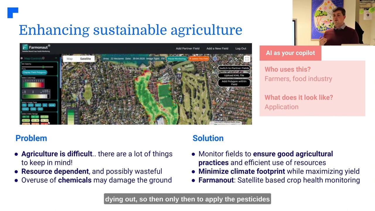
Crop Health Monitoring: A Holistic Approach
Crop health monitoring is no longer limited to visual inspections and sporadic soil tests. Modern satellite farming techniques provide a comprehensive view of crop health, including:
- Nutrient deficiencies
- Water stress
- Pest and disease pressures
- Growth rate anomalies
- Soil health indicators
This holistic approach allows farmers to address issues promptly, often before they become visible to the naked eye. The result is healthier crops, higher yields, and more sustainable farming practices.
Sustainable Agriculture Technologies: Farming for the Future
Sustainable agriculture technologies are at the forefront of modern farming practices. By leveraging satellite data and AI, farmers can implement more environmentally friendly approaches, such as:
- Precision fertilizer application
- Targeted pest management
- Reduced water usage
- Soil conservation practices
- Carbon sequestration monitoring
These technologies not only benefit the environment but also contribute to long-term farm profitability by reducing input costs and improving resource efficiency.
Smart Irrigation Systems: Precision Water Management
Smart irrigation systems represent a significant advancement in water management for agriculture. By integrating satellite data, weather forecasts, and soil moisture sensors, these systems can:
- Automatically adjust irrigation schedules
- Apply water only where and when it’s needed
- Reduce water waste and runoff
- Improve crop water use efficiency
- Minimize the risk of over- or under-watering
The result is not only water conservation but also improved crop health and yield, as plants receive optimal hydration throughout their growth cycle.
Pest and Disease Detection in Crops: Early Warning Systems
Pest and disease detection in crops has been revolutionized by satellite technology and AI. These advanced systems can:
- Identify early signs of pest infestations or disease outbreaks
- Map the spread of pests or diseases across fields
- Predict potential outbreaks based on environmental conditions
- Guide targeted interventions for more effective control
By detecting issues early, farmers can implement targeted treatments, reducing the need for broad-spectrum pesticides and minimizing crop losses.
Agricultural Drone Imaging: A Closer Look
While satellites provide a broad view, agricultural drone imaging offers a complementary, high-resolution perspective. Drones equipped with multispectral cameras can:
- Capture detailed images of specific field areas
- Provide real-time data on crop conditions
- Assist in precise application of inputs
- Monitor hard-to-reach or sensitive areas
The combination of satellite and drone imagery provides farmers with a comprehensive toolkit for precision agriculture.
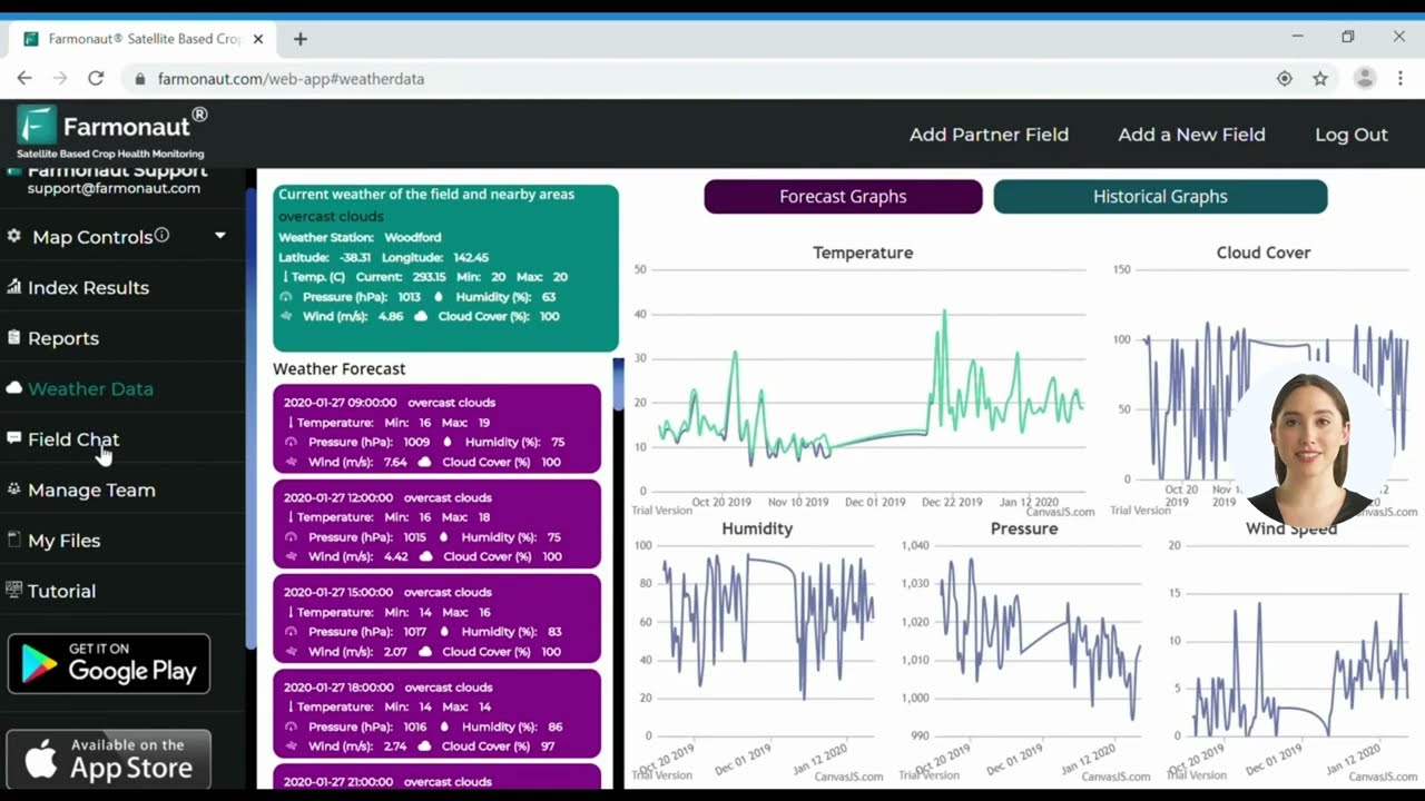
Soil Moisture Analysis: The Foundation of Crop Health
Soil moisture analysis is crucial for effective crop management. Satellite-based techniques for assessing soil moisture include:
- Microwave remote sensing
- Thermal infrared imaging
- Integration with ground-based sensors
By accurately monitoring soil moisture levels, farmers can optimize irrigation, prevent water stress, and improve nutrient uptake by crops.
Crop Yield Prediction: Planning for Success
Crop yield prediction has become more accurate and reliable with the advent of satellite farming and AI. These technologies enable:
- Early-season yield forecasts
- Identification of high and low-yielding areas within fields
- Assessment of the impact of management practices on yield
- More precise harvest planning and resource allocation
Accurate yield predictions help farmers make informed decisions about marketing, storage, and financial planning.
Spectral Analysis in Agriculture: Seeing Beyond the Visible
Spectral analysis in agriculture involves examining the light reflected by crops across different wavelengths. This powerful technique can reveal information about:
- Plant health and stress levels
- Nutrient content in leaves
- Water content in vegetation
- Presence of pests or diseases
By analyzing spectral signatures, farmers can gain deep insights into crop conditions that are invisible to the naked eye.
Farm Management Software: Integrating Data for Success
Farm management software plays a crucial role in modern agriculture by:
- Centralizing data from multiple sources
- Providing user-friendly interfaces for data visualization
- Generating reports and recommendations
- Facilitating collaboration among farm stakeholders
- Integrating with other farm technologies and equipment
These software platforms are essential for turning the wealth of data provided by satellite farming into practical, actionable insights.
Precision Farming Techniques: Putting It All Together
Precision farming techniques combine all the technologies we’ve discussed to create a holistic approach to agriculture. These techniques include:
- Variable rate application of inputs
- Site-specific crop management
- Precision planting and harvesting
- Integrated pest management
- Data-driven decision making
By adopting these techniques, farmers can optimize their operations, reduce costs, and improve sustainability.
Agricultural Sustainability Solutions: Farming for the Future
Agricultural sustainability solutions are crucial for ensuring long-term food security and environmental health. Satellite farming contributes to sustainability by:
- Reducing resource waste
- Minimizing environmental impact
- Improving crop resilience to climate change
- Enhancing biodiversity through targeted management
- Supporting carbon sequestration efforts
These solutions are not just good for the planet; they also contribute to the long-term viability and profitability of farms.
Comparison: Traditional Farming vs. Satellite-Assisted Farming with Farmonaut
| Aspect | Traditional Farming Methods | Satellite-Assisted Farming with Farmonaut |
|---|---|---|
| Crop Health Monitoring | Periodic visual inspections | Daily NDVI analysis and AI-powered insights |
| Irrigation Efficiency | Based on general schedules or visual assessment | Up to 30% increase in water efficiency through precise monitoring |
| Pest Detection | Manual scouting and observation | Early pest detection in 95% of cases using spectral analysis |
| Yield Prediction | Estimation based on historical data and experience | AI-driven predictions with up to 90% accuracy |
| Resource Application | Uniform application across fields | Variable rate application based on field variability maps |
| Data Collection | Manual record-keeping | Automated data collection and analysis |
| Decision Making | Intuition and experience-based | Data-driven insights and AI recommendations |
Conclusion: The Future of Agriculture is Here
As we’ve explored throughout this article, satellite farming and AI are truly revolutionizing agriculture. From crop health monitoring to precision farming techniques, these technologies are empowering farmers to make more informed decisions, optimize resource use, and increase productivity while promoting sustainability.
The future of agriculture is data-driven, precision-focused, and sustainable. By embracing these innovative technologies, farmers can not only improve their yields and profitability but also contribute to global food security and environmental conservation.
Are you ready to take your farming to the next level? Explore the possibilities of satellite farming and AI-powered agriculture with Farmonaut. Our cutting-edge solutions can help you transform your agricultural practices and achieve new heights of efficiency and sustainability.

Ready to experience the power of satellite farming? Try Farmonaut today!


For developers interested in integrating our satellite and weather data into their own systems, check out our API and API Developer Docs.
Frequently Asked Questions
Q: What is satellite farming?
A: Satellite farming, also known as precision agriculture, uses satellite imagery and other remote sensing technologies to monitor crop health, optimize resource use, and improve farm management decisions.
Q: How does NDVI work in agriculture?
A: NDVI (Normalized Difference Vegetation Index) measures the difference between near-infrared and red light reflection from plants. Healthy vegetation reflects more near-infrared light, resulting in higher NDVI values, which indicate better crop health.
Q: Can satellite farming help small-scale farmers?
A: Yes, satellite farming technologies are becoming increasingly accessible and affordable, allowing small-scale farmers to benefit from precision agriculture techniques and improve their productivity.
Q: How accurate are crop yield predictions using satellite data?
A: Crop yield predictions using satellite data and AI can be highly accurate, often reaching 90% or higher accuracy when combined with ground-truthing and historical data.
Q: What are the main benefits of using AI in agriculture?
A: AI in agriculture helps in early detection of crop health issues, optimizes resource use, improves decision-making, and enhances overall farm productivity and sustainability.


