Oregon Gold Exploration Uncovers New High-Grade Zones in Major Expansion
Gold exploration in Oregon has reached a major turning point, ushering in a new era for the region’s historic mining districts. With Provenance Gold Corp’s substantial expansion of the Eldorado project area, stretching across thousands of acres and encompassing both new claims and optioned properties, we are now witnessing significant discoveries in high-grade, bulk tonnage, diorite-hosted gold across district-scale resources.
Centered in Malheur County, Oregon, and building upon centuries of historic mineral claims, the latest exploration programs have not only confirmed the presence of rich surface and near-surface mineral zones but have revealed that the potential gold resources of this region run far deeper—both literally and figuratively—than previously imagined.
In this comprehensive blog, we explore how these “gold exploration oregon” initiatives are transforming the region, what new geological and structural insights are emerging from the Eldorado Gold Project and its expanded property, and how this could catalyze the next gold rush in the Pacific Northwest.

Project Overview: Eldorado Gold Project and Area Expansion
The Eldorado Gold Project exemplifies the robust potential of modern gold exploration in Oregon. Spearheaded by Provenance Gold Corp., this expansion consolidates and extends the Company’s district-scale gold property in eastern Oregon. Through a blend of strategic staking and a pivotal option agreement, the total area now covers approximately 5,670 acres (22.95 km2), making the district one of the most promising mineral claims in Oregon.
- Newly Staked Claims: 285 Bureau of Land Management (BLM) mineral claims, covering 4,330.85 acres (17.53 km2), collectively known as Eldorado East, were recently added about 5 km from the core property.
- Optioned Sunday Hill Property: The historic Sunday Hill Mine area, comprising 10 mineral claims and 198.4 acres (0.80 km2), is now under option, further boosting the scope and value of the whole package.
- Randall Mine & Additional Claims: 14 BLM claims covering 260 acres (1.05 km2) have been staked, situated approximately 1 km northeast of the core area.
- Consolidated District: In all, the combined claim area now totals an impressive 22.95 km2—a district-scale land position that encompasses key geologic structures, high-grade historical gold mining zones, and promising new mineralization horizons.
This strategic expansion positions Provenance as a leading player in what could become the next large-scale gold producing district in the U.S. Northwest.


Historic Background: The Sunday Hill, Randall Mines & the Golden Legacy of Oregon
The legacy of gold mining in Oregon is a tale as rich as the veins that run beneath its hills. Historical accounts and resource estimates for sites on the Sunday Hill property—dating as far back as the 1920s—paint a clear picture of a historical gold mining district of regional importance:
- Sunday Hill Mine: Historically drilled in the 1980s, Capri Resources reported a near-surface gold zone averaging 23.15 g/t gold, with a historical resource of 231,000 tons, just 10.7 meters from the surface. The zone, up to 18.3 meters thick at depth, remains open in all directions, underscoring untapped resource potential.
- Randall Mine: Located 500 meters to the south, this site holds a historical resource of 207,000 tons grading at 8 g/t gold. Soil sampling has suggested a gold-enriched corridor connecting both mines, demonstrating the significance of this zone within the district.
- Bulk Tonnage System: Historical soil surveys and prospect reports dating back to the early 20th century indicate extensive bulk tonnage gold mineralization over an 1189 by 152-meter area of altered diorite. The prevalence of placer and lode gold deposits in the region speaks to the consistent, long-term nature of surface gold mineralization.
While historical resource estimates do not conform to present-day CIM categories, modern exploration and data compilation continue to verify the area’s immense potential for new discoveries and economic development.
Geology and Structural Controls: Diorite Bodies, Gold Zones, and the Mormon Basin
At the core of Oregon’s gold exploration renaissance is a sophisticated understanding of the local geology and structural controls that host gold mineralization. The Eldorado and Eldorado East blocks are located within a vast, northeast-trending structural zone, where mineralized diorite bodies are exposed at surface and at depth.
Diorite-Hosted Gold: A Bulk Tonnage Opportunity
- Diorite-Hosted Mineralization: The gold mineralization is closely correlated with strongly altered diorite and adjacent metasedimentary rocks. Historic miners focused on high-grade underground lode deposits, but present-day work reveals that the diorite is pervasively mineralized over large areas, creating a significant bulk tonnage opportunity.
- Mormon Basin: This pivotal area, incorporating much of the new claim block, has a prolific density of historic lode and placer gold mines. Many small drainages have been placer mined, pointing to a pervasively mineralized system across both surface and underground gold zones.
- Metallurgical Quality: Reports describe free-milling gold with recoveries of over 90% using gravity and flotation, affirming high-quality, accessible mineralization.
With a structural style matching that recognized across major zones in the Eldorado core claim, these geological attributes underscore the potential for further district-scale discoveries.
Precision plantation and forest monitoring solutions can play a critical role in contemporary resource and sustainability management for large landholdings and mining-impacted areas.
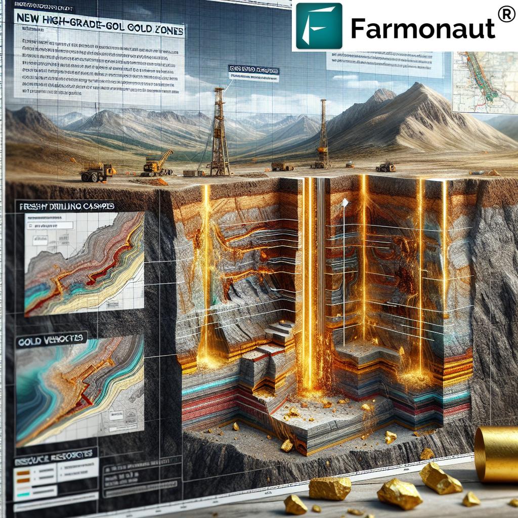
Ore Bodies, Resource Estimates and New High-Grade Zones
What makes the latest expansion truly remarkable is the context and scale of the newly identified high-grade gold zones, many of which are hosted in or adjacent to diorite bodies. These discoveries not only reinforce the case for further district-wide exploration but also suggest the presence of a much larger mineralized system, capable of sustaining bulk-tonnage and selective high-grade mining.
- Sunday Hill Zone: Averaging an impressive 23.15 g/t—and hosted in near-surface rock less than 10.7 meters deep—this remains one of the most exciting gold mineral resources in Oregon. Its open-ended nature in all directions magnifies its expansion potential.
- Randall Mine Zone: With a historical estimate of 207,000 tons at 8 g/t gold, located just 500 meters south of Sunday Hill, it provides the best example of interconnected lode gold deposits across the claim block.
- Soil Gold Anomalies: Capri’s historical soil map demonstrates a gold-enriched belt running between Sunday Hill and Randall, with continued soil anomalies extending outside the mapped area—a classic sign of underexplored surface gold mineralization.
- Eldorado East Diorite Gold: Widespread gold mineralization in altered diorite was historically sampled at an average of 5.75 g/t across new claims, indicating significant zone-scale resources.
- Depth & Width: Gold mineralization is reported to widen to 18.3 meters at its deepest exposure, highlighting the bulk mining potential.
Given the bulk nature of these mineralized zones and evidence of extensive past placer mining, these new resources could transform both the regional and broader U.S. gold output landscape.
Discover how blockchain-based traceability can secure and bring transparency to mineral and resource supply chains—benefitting not just agriculture but also mining and natural resources industries.
Comparison Table of Key Gold Exploration Zones and Estimated Resource Data
| Zone Name | Estimated Gold Grade (g/t) | Estimated Resource Size (tonnes) | Host Rock Type | Discovery Date | Notes on Expansion |
|---|---|---|---|---|---|
| Sunday Hill Zone | 23.15 | 231,000 | Diorite (strongly altered) | 1980s (re-evaluation) | Open in all directions; near surface, expansion drilling planned |
| Randall Mine Zone | 8 | 207,000 | Diorite/metasediments | 1930s (estimation) | Open-ended; connected by gold-enriched soil zone; 500 meters south of Sunday Hill |
| Eldorado East Diorite | 5.75* | – | Diorite (area: 1189x152m sampled) | 1926 | Extensive area of alteration; historical average sample across hundreds of meters |
| Mormon Basin Mines/Prospects | Varied (high-grade) | – | Diorite + Placers | Late 1800s–Early 1900s | Numerous historic prospects and placer mining; little modern systematic exploration |
*Weighted average from 21 samples as per Capri Resources, 1926 – data compilation in progress.
Strategic Expansion: Mineral Claims, Land Position & Discovery Upside
Locked-In Value Through Claim Expansion
This most recent expansion of exploration area underscores the company’s strategy of building contiguous positions in the most geologically favorable zones of eastern Oregon. The staked large tracts of BLM mineral claims, for example, increase Provenance’s operational flexibility, while the Sunday Hill option agreement grants rights to a revered portion of the historic gold mining district. This creates a synergistic effect, linking high-grade lode, broad diorite-hosted bulk tonnage, and adjacent placer gold zones across several square kilometers.
- Option agreement terms allow for gradual expenditure (back loaded), freeing up resources for immediate exploration like RC drilling on high-potential gold zones.
- New claims extend proven mineralized horizons, offering untested soil, surface, and geophysical anomalies for rapid assessment.
- The area is home to numerous unexplored historic mines and prospects—which, when reevaluated with modern methods, could transform resources into viable mineral reserves.
For any explorer, maximizing claim coverage in a recognized district is essential to ensuring future upside as new drill discoveries are made. The continuous work of data compilation and new sampling is crucial for advancing historical gold mineralization into compliant modern resource categories.
Learn more about real-time carbon footprint tracking—vital for mining and large-scale land use—to improve sustainability, compliance, and public trust in today’s resource industries.
Exploration Methods: Surface, Soil and Drilling Approaches
- Ground Truthing & Data Compilation: Ongoing work includes thorough ground-based surveys, mapping, and review of historic literature, such as data from Capri Resources and previous mining operations near the Sunday Hill and Randall mines.
- RC Drilling: The company is commencing a drilling program on targets with proven gold at surface and down dip. These methods will both confirm historical grades and expand the resources, potentially reclassifying historical resource estimates in the CIM system down the line.
- Soil & Geochemical Surveys: Historical and new soil geochemical studies have been invaluable in delineating the extents of gold-associated anomalies, particularly along the corridor between Sunday Hill and Randall zones.
- Geologic Modelling: Leveraging structural geology models, geophysics (potential field and EM data), and integration with satellite imagery, the new claim block is receiving a modern exploration-specific review.
Satellite and AI-based monitoring—like that offered with the Farmonaut Agro-Admin App—can further support land status analysis, track vegetation change, and enable smarter decision-making for both large-scale mine exploration and adjacent agriculture or environmental projects.
Sustainability, Resource Management, and Traceability in the Mining Sector
With large-scale gold exploration comes the responsibility to sustainably manage land, water, and adjacent agricultural resources. Advanced resource management and traceability tools are increasingly in demand among explorers, landowners, and local stakeholders, ensuring compliant, responsible development and transparent supply chains.
- Real-time land surface monitoring identifies environmental impacts and helps mitigate disturbances during every phase of mineral exploration and mining.
- Blockchain-enabled traceability platforms (see Farmonaut product traceability) secure all transactions and resource movements for end-to-end transparency—critical for mining sector trust and market access.
- Fleet management tools (learn more) increase operational efficiency, ensuring that supply chain logistics—from equipment to raw material transport—are streamlined and climate-friendly.
Environmental compliance and community engagement are essential. Area resource estimation, carbon footprint analysis, and transparent information sharing are all made possible via the right technology stack, as provided by Farmonaut’s suite of satellite and AI products.
The Future Potential of Oregon’s Gold Districts: Economic Impact, Exploration Upside & Modernization
The eastward expansion of the Eldorado Gold Project presents a transformative opportunity—not only for Provenance Gold Corp, but for the entire Oregon mining industry. Here’s why this district is being closely watched:
- Consolidation of large, contiguous claims unlocks economies of scale for future development.
- Underexplored historic mines and new high-grade zones could yield major boosts in resource estimates, potentially making mineral resources oregon competitive on a national level.
- Modern exploration methods (integration of satellite, AI, blockchain data) will increase both speed and accuracy of resource definition—and set new standards for environmental compliance.
- Future drilling and sampling campaigns offer the possibility to confirm (or exceed) historical results, potentially elevating the project’s status to that of Oregon’s premier new mining district.
The next chapter in “gold exploration oregon” will be defined by how well exploration companies can leverage both cutting-edge mineral extraction technology and responsible stewardship over these valuable resources.
Farmonaut: Satellite Agricultural Monitoring & Land Resource Tools
Farmonaut is an agriculture technology pioneer providing advanced, affordable, and scalable satellite-based farm management solutions for all sizes—from the single landowner to the large-scale agribusiness. By blending real-time crop health monitoring, AI-driven advisory, blockchain-secure product traceability, carbon footprinting, and integrated fleet/resource management, Farmonaut’s platform empowers stakeholders to manage and optimize land resources efficiently.
- Accessible: Use via web, iOS, and Android apps; also accessible via API (developer docs) for easy integration.
- Advanced Monitoring: Crop health (NDVI), soil moisture, weather patterns, and advisory tools to improve land management—proven valuable for both agricultural and natural resource managers, including those operating in areas with mining, reclamation, or legacy gold workings.
- Scalable & Transparent Pricing: Affordable subscription model ideal for single farm units, multinational operations, and governmental programs supporting sustainability and emissions reduction.
- Supply Chain Trust: Blockchain-based traceability for products and resources boosts market access and ethical compliance, especially valuable for high-value minerals or large volume commodity crops.
- Operational Efficiency: Fleet and resource management tools ensure maximum value from every working vehicle and asset, critical for both farm and mining enterprises increasingly held to higher ESG standards.
- Supporting Sustainability: Features like carbon footprinting and area monitoring enable environmental stewardship for organizations of any size or sector.
Explore affordable plans below, designed for farms and natural resource managers of all scales:
Frequently Asked Questions (FAQ) about Oregon Gold Exploration and Resources
-
Q: What makes the Eldorado Project significant for gold exploration in Oregon?
A: The project’s significance lies in its scale (over 22.95 km2), discovery of multiple high-grade diorite-hosted zones, and the seamless integration of historic and new mineral claims, opening a new chapter for district-scale resource development.
-
Q: How reliable are the historical resource estimates for Sunday Hill and Randall Mines?
A: While historical, these estimates are based on credible prior operator data but will require modern confirmation via drilling, re-sampling, and further geologic work before they can be classified as current mineral resources under CIM standards.
-
Q: What role do diorite bodies play in gold mineralization?
A: Diorite bodies in the Eldorado district are pervasively mineralized and strongly correlated with both historic high-grade lode and bulk tonnage placer gold deposits. Their structure creates extensive environments for gold precipitation and retention.
-
Q: What exploration techniques are being used to define these gold zones?
A: The campaign uses initial ground truthing, compilation of historic data, surface geochemistry, RC drilling, and geologic modeling—often enhanced by satellite and AI-driven monitoring techniques.
-
Q: How do modern land and resource management tools support responsible exploration?
A: Satellite monitoring, blockchain-based traceability, and real-time fleet/resource tools (such as those provided by Farmonaut) support better compliance, operational efficiency, and transparency throughout the gold exploration and mining lifecycle.
-
Q: Where can I learn more about integrating precision agriculture and natural resource monitoring?
A: Visit Farmonaut’s official site to access in-depth information about their solutions for farm and land resource monitoring, traceability, and sustainability programs.
Conclusion: Oregon’s New Gold Frontier and Your Next Steps
The latest expansion in Oregon gold exploration—anchored by the major scale-up at the Eldorado Project—exemplifies what’s possible when historic mineral districts are revitalized by modern science, strategic staking, and relentless pursuit of new data. With high-grade zones confirmed, a robust network of placer and lode gold deposits, and a land position that rivals many established gold camps, Provenance Gold Corp. is at the frontier of what could soon become Oregon’s most significant new gold district.
Ambitious explorers, investors, and land managers should keep close watch as this area moves swiftly from data compilation and confirmation drilling toward resource delineation and development. The fusion of mineral exploration best practices and emerging resource management technologies—notably, the advantages of Farmonaut’s satellite-based monitoring suite—will be fundamental to unlocking the full value potential of the region.
As exploration moves forward, transparent information dissemination and responsible environmental stewardship must remain top priorities. By keeping pace with both traditional exploration methods and next-generation tools for land, soil, and resource management, Oregon’s gold mining future shines brighter than ever.
Start exploring, monitoring, and managing your resources with precision. Integrate Farmonaut’s API for satellite imagery insights, or review the API Documentation to empower your geoscience and resource workflows.