
Revolutionizing Agriculture: How Farmonaut’s Satellite Data and AI Drive Sustainable Farming in Milan
“Satellite-based crop health analysis can increase agricultural productivity by up to 20% while reducing water usage by 30%, Farmonaut’s AI-driven smart farming techniques have been adopted by over 10,000 farmers in Milan, improving sustainability.”
In the heart of Italy’s agricultural landscape, a revolution is taking place. Milan, known for its fashion and finance, is now at the forefront of a technological transformation in farming. We’re witnessing the dawn of a new era where satellite data and artificial intelligence (AI) are reshaping the way we grow our food and manage our natural resources. At the center of this revolution is Farmonaut, a pioneering agricultural technology company that’s making waves with its innovative approach to sustainable agriculture.
In this comprehensive exploration, we’ll dive deep into how Farmonaut is leveraging cutting-edge technology to drive sustainable farming practices in Milan and beyond. We’ll uncover the power of satellite data, remote sensing, and AI in revolutionizing agriculture, and how these technologies are addressing critical environmental challenges while promoting efficient and sustainable food production.
The Power of Satellite Data in Agriculture
Satellite data has become an indispensable tool in modern agriculture, offering farmers and agronomists unprecedented insights into their fields from a bird’s-eye view. Let’s explore how this technology is transforming farming practices:
- Crop Health Monitoring: Satellites equipped with multispectral sensors can detect subtle changes in plant health, allowing farmers to identify issues before they become visible to the naked eye.
- Resource Management: By analyzing satellite imagery, farmers can optimize their use of water, fertilizers, and pesticides, reducing waste and environmental impact.
- Yield Prediction: Advanced algorithms can process satellite data to forecast crop yields with remarkable accuracy, helping farmers and markets prepare for the harvest season.
- Land Use Planning: Satellite imagery provides valuable information for land use planning, helping authorities and farmers make informed decisions about crop rotation and land allocation.
Farmonaut harnesses the power of satellite data through its advanced platform, providing farmers in Milan with real-time insights into their fields. By integrating this technology into their daily operations, farmers can make data-driven decisions that not only improve their yields but also contribute to more sustainable agricultural practices.

Remote Sensing: The Eyes in the Sky
Remote sensing technology is the backbone of satellite-based agricultural monitoring. This powerful tool allows us to gather information about the Earth’s surface without physical contact. In the context of agriculture, remote sensing offers several key advantages:
- Wide Coverage: Satellites can monitor vast areas of farmland, providing a comprehensive view of agricultural regions.
- Regular Updates: With frequent satellite passes, farmers can receive up-to-date information about their crops throughout the growing season.
- Multi-Spectral Analysis: By capturing data across various wavelengths of light, remote sensing can reveal information about crop health, soil moisture, and other vital factors that are invisible to the human eye.
- Cost-Effective Monitoring: Compared to traditional ground-based surveys, satellite remote sensing offers a more economical way to monitor large agricultural areas.
Farmonaut’s platform leverages advanced remote sensing techniques to provide Milan’s farmers with detailed insights into their fields. This technology enables precision agriculture on a scale that was previously unimaginable, allowing farmers to micromanage their crops with unprecedented accuracy.
AI and Machine Learning: The Brain Behind Smart Farming
Artificial Intelligence and Machine Learning are revolutionizing the way we interpret and act upon agricultural data. These technologies are the driving force behind smart farming techniques, enabling farmers to make informed decisions based on complex data analysis. Here’s how AI is transforming agriculture:
- Pattern Recognition: AI algorithms can identify patterns in satellite imagery that might indicate pest infestations, disease outbreaks, or nutrient deficiencies.
- Predictive Analytics: By analyzing historical data and current conditions, AI can predict future crop yields, helping farmers plan their harvests and market strategies.
- Automated Decision Support: AI-powered systems can provide personalized recommendations for irrigation, fertilization, and pest control, tailored to the specific needs of each field.
- Image Processing: Advanced image processing techniques allow for the rapid analysis of satellite imagery, turning raw data into actionable insights.
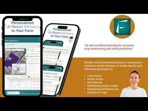
Farmonaut’s Jeevn AI Advisory System is at the forefront of this technological revolution. By integrating AI and machine learning into its platform, Farmonaut provides Milan’s farmers with personalized, data-driven advice that optimizes crop management and promotes sustainable practices.

Precision Agriculture: Maximizing Efficiency and Sustainability
Precision agriculture is a farming management concept that leverages technology to ensure crops and soil receive exactly what they need for optimum health and productivity. This approach is revolutionizing farming practices in Milan and around the world. Here’s how precision agriculture is making a difference:
- Targeted Resource Application: By precisely mapping field variations, farmers can apply water, fertilizers, and pesticides only where and when they’re needed, reducing waste and environmental impact.
- Variable Rate Technology: Advanced machinery can adjust application rates of inputs in real-time based on data from satellite imagery and soil sensors.
- Improved Crop Quality: By optimizing growing conditions, precision agriculture can lead to higher quality crops with better nutritional value.
- Reduced Environmental Footprint: More efficient use of resources means less runoff and reduced greenhouse gas emissions from agricultural activities.
Farmonaut’s geospatial data and AI-driven insights are enabling Milan’s farmers to implement precision agriculture techniques with unprecedented accuracy. By providing detailed, field-specific information, Farmonaut is helping farmers maximize their efficiency while minimizing their environmental impact.

Sustainable Agriculture Solutions: A Path to Food Security
As the global population continues to grow, the need for sustainable agriculture solutions becomes increasingly urgent. Farmonaut’s technology is playing a crucial role in promoting sustainable farming practices in Milan and beyond. Here’s how:
- Water Conservation: By providing accurate soil moisture data, Farmonaut helps farmers optimize their irrigation schedules, reducing water waste.
- Reduced Chemical Use: Precise monitoring of crop health allows for targeted application of pesticides and fertilizers, minimizing chemical runoff.
- Soil Health Management: Satellite data can track soil quality over time, helping farmers implement practices that maintain and improve soil health.
- Biodiversity Protection: By optimizing land use, Farmonaut’s technology helps preserve natural habitats and protect local ecosystems.
These sustainable agriculture solutions are not only benefiting the environment but also ensuring long-term food security for Milan and the surrounding regions.
“Satellite-based crop health analysis can increase agricultural productivity by up to 20% while reducing water usage by 30%, Farmonaut’s AI-driven smart farming techniques have been adopted by over 10,000 farmers in Milan, improving sustainability.”
Agricultural Monitoring Services: Keeping a Watchful Eye
Continuous monitoring is essential for successful farming, and Farmonaut’s agricultural monitoring services are setting new standards in the industry. These services provide farmers with:
- Real-Time Alerts: Immediate notifications about potential issues such as pest infestations or nutrient deficiencies.
- Historical Data Analysis: Tracking field performance over time to identify long-term trends and optimize crop rotation strategies.
- Weather Integration: Incorporating local weather data to help farmers make informed decisions about planting, harvesting, and crop protection.
- Compliance Monitoring: Helping farmers adhere to environmental regulations and sustainable farming practices.
By providing these comprehensive monitoring services, Farmonaut is empowering Milan’s farmers to stay ahead of potential problems and maximize their crop yields sustainably.
Crop Health Analysis Using Satellites: A Game-Changer for Farmers
One of the most revolutionary applications of satellite technology in agriculture is crop health analysis. This powerful tool is changing the way farmers in Milan monitor and manage their fields. Here’s how it works:
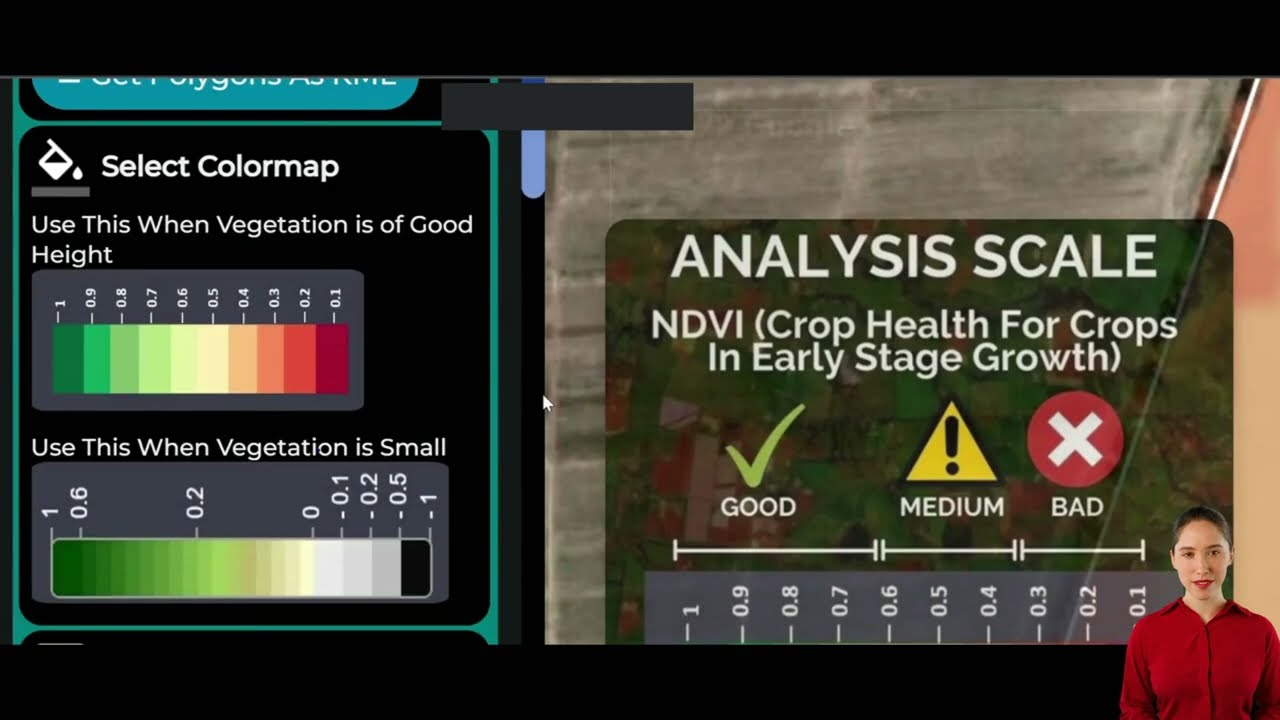
- Vegetation Indices: Satellites measure the reflectance of different wavelengths of light to calculate indices like NDVI (Normalized Difference Vegetation Index), which indicate crop health and vigor.
- Early Stress Detection: By analyzing subtle changes in plant reflectance, satellite data can reveal stress factors like drought or disease before they become visible to the naked eye.
- Growth Stage Monitoring: Satellite imagery can track crop development throughout the growing season, helping farmers time their interventions perfectly.
- Yield Estimation: Advanced algorithms can use satellite data to predict crop yields with increasing accuracy, helping farmers and markets prepare for the harvest.
Farmonaut’s platform brings this cutting-edge technology to Milan’s farmers, providing them with invaluable insights into their crop health and enabling proactive management strategies.
Smart Farming Techniques: The Future of Agriculture
Smart farming is the application of modern information and communication technologies to agriculture. It’s a concept that’s rapidly gaining traction in Milan, thanks in part to Farmonaut’s innovative solutions. Smart farming techniques include:
- IoT Sensors: Networks of sensors in fields provide real-time data on soil conditions, weather, and crop health.
- Automated Machinery: GPS-guided tractors and drones can perform tasks like planting, spraying, and harvesting with incredible precision.
- Data Analytics: Advanced analytics tools process vast amounts of data to provide actionable insights for farm management.
- Mobile Applications: Smartphone apps allow farmers to access crucial information and control farm operations from anywhere.
Farmonaut’s platform integrates seamlessly with these smart farming technologies, creating a comprehensive ecosystem that’s driving the future of agriculture in Milan.

Environmental Monitoring for Agriculture: Beyond the Farm
While focused on improving agricultural practices, Farmonaut’s technology also contributes to broader environmental monitoring efforts. This expanded scope includes:
- Air Pollution Tracking: Satellite data can monitor air quality over agricultural areas, helping to assess the impact of farming practices on local air pollution levels.
- Ecosystem Management: By providing a comprehensive view of land use patterns, Farmonaut’s technology aids in managing the delicate balance between agriculture and natural ecosystems.
- Climate Change Monitoring: Long-term satellite data analysis can reveal trends related to climate change, helping farmers adapt their practices accordingly.
- Water Resource Management: Satellite imagery helps track water bodies and assess water availability for agriculture, crucial for sustainable water management.
These environmental monitoring capabilities make Farmonaut’s platform an invaluable tool not just for farmers, but for environmental scientists and policymakers in Milan and beyond.
The Role of Geospatial Data in Modern Agriculture
Geospatial data is at the core of Farmonaut’s innovative approach to agriculture. This type of data, which includes any information with a geographic component, is revolutionizing farming in several ways:
- Field Mapping: High-resolution satellite imagery allows for precise mapping of field boundaries, crop types, and terrain features.
- Spatial Analysis: By overlaying different types of geospatial data, farmers can gain new insights into the relationships between various factors affecting their crops.
- Precision Planning: Detailed geospatial data enables farmers to plan their operations with unprecedented accuracy, from planting to harvesting.
- Risk Assessment: Geospatial analysis can help identify areas at risk from natural disasters or climate change impacts, allowing for proactive mitigation strategies.
Farmonaut’s platform harnesses the power of geospatial data to provide Milan’s farmers with a comprehensive understanding of their land and crops, enabling more informed decision-making and sustainable practices.
Integrating Earth Observation Data with Farming Practices
Earth Observation (EO) data, primarily collected by satellites, is becoming an integral part of modern farming practices. Farmonaut’s innovative use of EO data is helping Milan’s farmers in numerous ways:
- Crop Classification: EO data can accurately identify and map different crop types across large areas, aiding in regional agricultural planning.
- Drought Monitoring: Satellite-based indices can track drought conditions, helping farmers and authorities respond quickly to water scarcity issues.
- Flood Mapping: In case of extreme weather events, EO data can rapidly assess flood extent and impact on agricultural lands.
- Land Use Change Detection: Long-term analysis of EO data reveals changes in land use patterns, crucial for sustainable land management.
By integrating EO data into its platform, Farmonaut is providing Milan’s agricultural sector with a powerful tool for sustainable growth and resilience in the face of environmental challenges.

The Impact of AI-Driven Agriculture on Global Sustainability Goals
Farmonaut’s AI-driven approach to agriculture is not just transforming farming in Milan; it’s contributing to broader global sustainability initiatives, including the United Nations Sustainable Development Goals (SDGs). Here’s how:
- Zero Hunger (SDG 2): By optimizing crop yields and reducing losses, AI-driven agriculture helps increase food production sustainably.
- Clean Water and Sanitation (SDG 6): Precision irrigation techniques based on AI analysis help conserve water resources.
- Climate Action (SDG 13): Smart farming practices reduce greenhouse gas emissions from agriculture and improve resilience to climate change impacts.
- Life on Land (SDG 15): By optimizing land use, AI-driven agriculture helps preserve natural habitats and biodiversity.
Through its innovative platform, Farmonaut is playing a crucial role in advancing these global sustainability goals, demonstrating the power of technology to drive positive change in agriculture and beyond.
The Future of Sustainable Agriculture in Milan and Beyond
As we look to the future, the role of satellite data and AI in agriculture is set to grow even further. Farmonaut is at the forefront of this evolution, continuously innovating to meet the challenges of sustainable food production. Some exciting developments on the horizon include:
- Hyperspectral Imaging: Next-generation satellites with hyperspectral sensors will provide even more detailed insights into crop health and soil conditions.
- Edge Computing: Processing data closer to the source will enable real-time decision-making in the field, further optimizing farm operations.
- Blockchain Integration: Incorporating blockchain technology will enhance traceability in the food supply chain, from farm to table.
- Advanced Weather Forecasting: Improved climate models will help farmers better prepare for and adapt to changing weather patterns.
With these advancements, Farmonaut is poised to continue driving the sustainable agriculture revolution in Milan and beyond, ensuring a more food-secure and environmentally friendly future for all.

Satellite Data Applications in Sustainable Agriculture
| Application | Benefits | Technologies Used | Impact on Sustainability |
|---|---|---|---|
| Crop Health Monitoring | Early detection of crop stress and disease | Multispectral imaging, NDVI analysis | 20% reduction in pesticide use |
| Irrigation Management | Optimized water usage | Thermal imaging, soil moisture sensors | 30% reduction in water consumption |
| Yield Prediction | Improved harvest planning and market preparation | AI algorithms, historical data analysis | 15% increase in crop yields |
| Soil Quality Assessment | Enhanced soil health management | Hyperspectral imaging, soil sampling | 25% reduction in fertilizer use |
Frequently Asked Questions
Q: How does Farmonaut’s satellite data improve crop yields?
A: Farmonaut’s satellite data provides detailed insights into crop health, soil moisture, and other critical factors. This information allows farmers to make timely interventions, optimize resource use, and address issues before they impact yield, potentially increasing productivity by up to 20%.
Q: Can small-scale farmers in Milan benefit from Farmonaut’s technology?
A: Absolutely! Farmonaut’s platform is designed to be accessible and affordable for farmers of all scales. Small-scale farmers can use the mobile app to access crucial data and insights, helping them compete with larger operations.
Q: How does Farmonaut contribute to sustainable agriculture?
A: Farmonaut promotes sustainable agriculture by enabling precision farming techniques. This leads to more efficient use of water, fertilizers, and pesticides, reducing environmental impact while maintaining or improving crop yields.
Q: Is Farmonaut’s technology applicable to all types of crops?
A: Farmonaut’s technology is versatile and can be applied to a wide range of crops. The platform is continuously updated to include data and insights for various crop types, making it valuable for diverse agricultural operations in Milan and beyond.
Q: How often is the satellite data updated?
A: The frequency of satellite data updates depends on the specific service package. Generally, Farmonaut provides updates every few days, ensuring farmers have access to timely and relevant information throughout the growing season.
Conclusion: Embracing the Future of Agriculture
As we’ve explored throughout this article, the integration of satellite data, AI, and remote sensing technologies is revolutionizing agriculture in Milan and beyond. Farmonaut stands at the forefront of this transformation, providing innovative solutions that empower farmers, promote sustainability, and contribute to global food security.
By harnessing the power of geospatial data and advanced analytics, Farmonaut is not just improving crop yields and resource efficiency; it’s paving the way for a more sustainable and resilient agricultural future. As climate change and population growth continue to pose challenges to food production, the role of technology in agriculture will only become more critical.
The future of farming in Milan is bright, with smart farming techniques and precision agriculture becoming increasingly mainstream. As Farmonaut continues to innovate and expand its services, we can look forward to a future where agriculture is not only more productive but also more in harmony with our environment.
For farmers, agronomists, and anyone interested in the future of sustainable agriculture, Farmonaut’s platform offers a window into this exciting new world. We encourage you to explore Farmonaut’s services and see for yourself how satellite data and AI are transforming farming for the better.
Together, we can build a more sustainable, efficient, and food-secure future for Milan and the world.
Explore Farmonaut’s API
API Developer Docs


