
Revolutionizing Agriculture: How Panchromatic Imagery Enhances Satellite Crop Monitoring and Precision Farming
“Panchromatic imagery can achieve spatial resolutions up to 0.31 meters, significantly enhancing crop classification and field detection accuracy.”
In the ever-evolving landscape of modern agriculture, we at Farmonaut are at the forefront of a technological revolution that’s transforming the way we monitor crops and manage farms. The integration of panchromatic imagery into satellite crop monitoring and precision farming practices has opened up new horizons for agricultural efficiency and sustainability. In this comprehensive exploration, we’ll delve into the power of panchromatic imagery and its profound impact on the agricultural sector.
Understanding Panchromatic Imagery in Agriculture
Panchromatic imagery represents a significant leap forward in remote sensing technology for agriculture. Unlike its multispectral counterparts, panchromatic images capture a broad range of the electromagnetic spectrum in a single band, resulting in high-resolution, black-and-white images that provide exceptional detail and clarity.
- High spatial resolution (typically 0.5-1m)
- Enhanced field boundary detection
- Improved crop classification accuracy
The application of panchromatic imagery in agriculture has revolutionized our ability to observe and analyze crop conditions with unprecedented precision. By leveraging this technology, we can now detect subtle changes in field patterns, identify individual plants, and even spot early signs of crop stress that might be invisible to the naked eye.
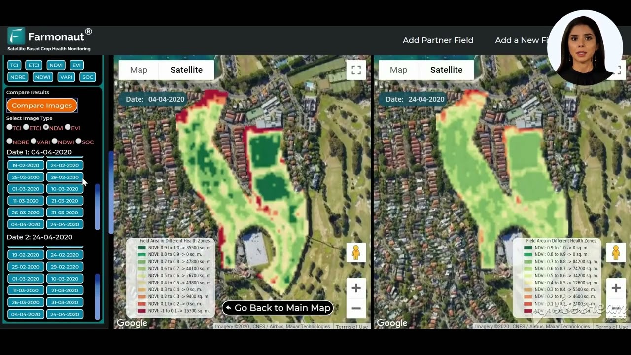
The Synergy of Panchromatic and Multispectral Imagery
While panchromatic imagery excels in spatial resolution, multispectral imagery offers rich spectral information across multiple bands. The true power of satellite crop monitoring emerges when we combine these two types of imagery:
| Imagery Type | Spatial Resolution | Spectral Information | Primary Applications | Advantages |
|---|---|---|---|---|
| Panchromatic | 0.5-1m | Single broad band | Field boundary detection, Crop classification | High detail for crop structure analysis |
| Multispectral | 10-30m | 4-8 bands | Crop health assessment, Vegetation indices | Effective for NDVI, NDWI calculations |
| Combined (Pansharpened) | 0.5-1m | 4-8 bands | Precision agriculture, Yield prediction | High resolution with spectral richness |
This synergy allows us to harness the best of both worlds, creating pansharpened images that combine the high spatial resolution of panchromatic data with the spectral richness of multispectral imagery. The result is a powerful tool for precision agriculture that enables us to:
- Accurately delineate field boundaries
- Identify crop types with greater precision
- Detect early signs of crop stress or disease
- Optimize irrigation and fertilizer application
Panchromatic Sharpening: Enhancing Multispectral Data
Panchromatic sharpening, or pansharpening, is a technique that merges high-resolution panchromatic images with lower-resolution multispectral data. This process significantly improves the spatial resolution of multispectral imagery, allowing for more detailed analysis of crop conditions.
At Farmonaut, we employ advanced pansharpening algorithms to provide our users with the highest quality satellite imagery for their agricultural needs. This enhanced imagery enables farmers and agronomists to:
- Identify individual plants within a field
- Assess crop row patterns and spacing
- Detect small-scale variations in crop health
- Improve the accuracy of crop yield predictions
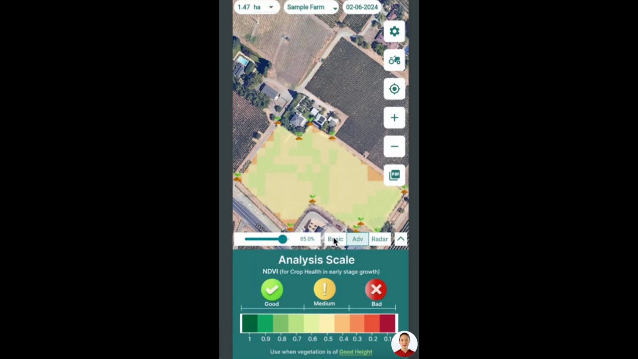
Vegetation Indices: NDVI and NDWI in Precision Agriculture
The combination of panchromatic and multispectral imagery allows for the calculation of crucial vegetation indices that are instrumental in precision agriculture. Two of the most important indices are:
Normalized Difference Vegetation Index (NDVI)
NDVI is a key indicator of plant health and biomass. By utilizing the red and near-infrared bands, NDVI provides valuable insights into:
- Crop vigor and density
- Photosynthetic activity
- Stress detection in plants
Normalized Difference Water Index (NDWI)
NDWI focuses on water content in vegetation and soil. This index is crucial for:
- Assessing soil moisture levels
- Monitoring drought conditions
- Optimizing irrigation schedules
By incorporating these indices into our satellite crop monitoring services, Farmonaut provides farmers with actionable insights to optimize their crop management strategies.
“Combining panchromatic and multispectral imagery can improve agricultural yield predictions by up to 30% compared to traditional methods.”
Advanced Analytics in Farming: Leveraging Panchromatic Data
The integration of panchromatic imagery into advanced analytics platforms has opened up new possibilities for data-driven decision-making in agriculture. At Farmonaut, we harness this technology to provide farmers with:
- Precise crop classification maps
- Early detection of pest infestations and diseases
- Accurate yield prediction models
- Optimized resource allocation strategies
Our advanced analytics combine panchromatic and multispectral data with machine learning algorithms to deliver insights that were previously unattainable. This allows farmers to make informed decisions about:
- Planting dates and crop rotations
- Variable rate application of inputs
- Harvest timing and logistics
Geospatial Intelligence in Agriculture
The fusion of panchromatic and multispectral imagery has significantly enhanced geospatial intelligence in agriculture. This advancement allows for:
- Precise mapping of agricultural landscapes
- Monitoring of land use changes over time
- Assessment of the impact of climate change on crop production
Geospatial intelligence derived from high-resolution satellite imagery enables agricultural stakeholders to:
- Identify suitable areas for specific crops
- Monitor and manage natural resources more effectively
- Plan and implement sustainable farming practices
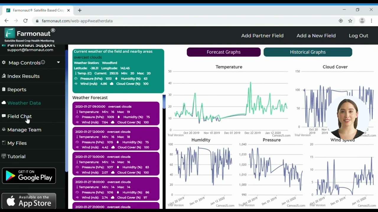
Soil Moisture Analysis and Management
Accurate soil moisture analysis is crucial for efficient water management in agriculture. Panchromatic imagery, when combined with multispectral data, enhances our ability to:
- Map soil moisture variability across fields
- Identify areas prone to water stress or waterlogging
- Optimize irrigation schedules and water use efficiency
At Farmonaut, we integrate this advanced soil moisture analysis into our platform, providing farmers with valuable insights for:
- Precision irrigation management
- Drought risk assessment
- Sustainable water resource planning
Harvest Monitoring and Yield Prediction
The high spatial resolution of panchromatic imagery, combined with multispectral data, has revolutionized harvest monitoring and yield prediction. Our advanced analytics at Farmonaut leverage this technology to provide:
- Accurate pre-harvest yield estimates
- Real-time monitoring of crop maturity
- Optimization of harvest timing and logistics
This level of precision allows farmers to:
- Plan harvesting operations more efficiently
- Reduce post-harvest losses
- Improve market timing and profitability
Applications in Forestry and Environmental Monitoring
The benefits of panchromatic imagery extend beyond traditional agriculture into forestry and environmental monitoring. In these fields, high-resolution imagery enables:
- Precise mapping of forest cover and deforestation
- Monitoring of forest health and biodiversity
- Detection of illegal logging activities
- Assessment of carbon sequestration potential
By providing detailed insights into forest ecosystems, panchromatic imagery supports sustainable forest management practices and conservation efforts.
The Role of Satellite Technology in Climate Change Adaptation
As climate change continues to impact agricultural systems worldwide, the role of satellite technology in adaptation strategies becomes increasingly crucial. Panchromatic and multispectral imagery allow us to:
- Monitor long-term changes in land use and crop patterns
- Assess the impact of extreme weather events on agriculture
- Develop resilient farming strategies
At Farmonaut, we’re committed to providing farmers with the tools they need to adapt to changing climate conditions and ensure food security for future generations.
The Future of Panchromatic Imagery in Agriculture
As satellite technology continues to advance, we anticipate even greater improvements in the resolution and capabilities of panchromatic imagery. Future developments may include:
- Sub-meter resolution imagery for individual plant analysis
- Integration with IoT devices for real-time field monitoring
- Advanced AI algorithms for automated crop management recommendations
These advancements will further enhance the precision and efficiency of agricultural practices, leading to more sustainable and productive farming systems.
Farmonaut’s Commitment to Precision Agriculture
At Farmonaut, we’re dedicated to harnessing the power of panchromatic imagery and advanced satellite technology to revolutionize agriculture. Our platform integrates cutting-edge remote sensing techniques with user-friendly interfaces to provide farmers with actionable insights for improved crop management.
We offer a range of services designed to meet the needs of farmers, agronomists, and agricultural businesses:
- Real-time crop health monitoring
- Precision irrigation management
- Yield prediction and harvest optimization
- Sustainable resource management tools
To experience the power of our satellite-based farm management solutions, explore our platform options:
Web App | Android App | iOS App
For developers interested in integrating our satellite and weather data into their own systems, we offer comprehensive API access. Learn more about our API capabilities and access our developer documentation:
Farmonaut API | API Developer Docs
Conclusion: Embracing the Future of Agriculture
The integration of panchromatic imagery into satellite crop monitoring and precision farming represents a significant leap forward in agricultural technology. By combining high-resolution spatial data with rich spectral information, we’re able to provide farmers with unprecedented insights into their crops and fields.
As we continue to face global challenges such as climate change, food security, and resource management, the role of advanced remote sensing technologies becomes increasingly crucial. At Farmonaut, we’re committed to staying at the forefront of these technological advancements, ensuring that farmers have access to the tools they need to thrive in an ever-changing agricultural landscape.
By embracing the power of panchromatic imagery and its applications in precision agriculture, we’re not just optimizing crop yields – we’re paving the way for a more sustainable and resilient future for agriculture worldwide.
FAQ Section
Q: What is panchromatic imagery, and how does it differ from multispectral imagery?
A: Panchromatic imagery captures a broad range of the electromagnetic spectrum in a single band, resulting in high-resolution black-and-white images. Multispectral imagery, on the other hand, captures data in multiple specific bands of the spectrum, providing rich color information but typically at lower spatial resolutions.
Q: How does panchromatic sharpening improve satellite imagery for agriculture?
A: Panchromatic sharpening, or pansharpening, combines high-resolution panchromatic images with lower-resolution multispectral data. This process enhances the spatial resolution of multispectral imagery, allowing for more detailed analysis of crop conditions and field characteristics.
Q: What are NDVI and NDWI, and why are they important in precision agriculture?
A: NDVI (Normalized Difference Vegetation Index) and NDWI (Normalized Difference Water Index) are vegetation indices derived from satellite imagery. NDVI is crucial for assessing plant health and biomass, while NDWI focuses on water content in vegetation and soil. Both indices provide valuable insights for crop management and irrigation optimization.
Q: How can farmers benefit from using Farmonaut’s satellite-based farm management solutions?
A: Farmers can benefit from Farmonaut’s solutions through real-time crop health monitoring, precision irrigation management, yield prediction, and sustainable resource management tools. These insights help optimize crop production, reduce input costs, and improve overall farm efficiency.
Q: Is Farmonaut’s technology suitable for small-scale farmers?
A: Yes, Farmonaut’s technology is designed to be accessible and beneficial for farmers of all scales, including small-scale farmers. Our platform offers affordable precision agriculture solutions that can help improve productivity and sustainability regardless of farm size.


