
Revolutionizing Agriculture: How Satellite Imagery and NDVI Drive Precision Farming Innovation

“Satellite imagery can detect crop health variations as small as 3 meters, enabling precise field management.”
In the ever-evolving landscape of modern agriculture, we are witnessing a remarkable transformation driven by cutting-edge technology. At the forefront of this revolution is the integration of satellite imagery for agriculture and precision farming technology. These innovative tools are reshaping the way we approach crop management, resource allocation, and sustainable farming practices. In this comprehensive exploration, we’ll delve into the world of agritech solutions, focusing on how satellite-based crop monitoring systems and agricultural data analytics are empowering farmers worldwide.
The Power of Satellite Imagery in Agriculture
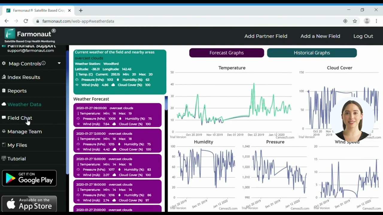
Satellite imagery has become an indispensable tool in the arsenal of modern farmers and agricultural professionals. By harnessing the power of remote sensing in agriculture, we can now gather vast amounts of data about crop health, soil conditions, and environmental factors with unprecedented accuracy and frequency. This wealth of information drives precision farming technology, enabling farmers to make data-driven decisions that optimize crop yields while minimizing resource usage.
- Real-time crop monitoring
- Early detection of crop stress and disease
- Precise irrigation management
- Optimized fertilizer application
- Accurate yield predictions
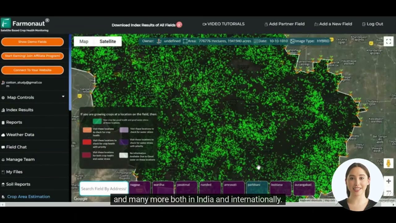
One of the most powerful applications of satellite imagery in agriculture is the use of NDVI (Normalized Difference Vegetation Index) for crop health assessment. NDVI allows us to quantify vegetation health by measuring the difference between near-infrared light (which healthy vegetation strongly reflects) and red light (which vegetation absorbs). This simple yet powerful index provides invaluable insights into crop vigor, stress levels, and overall health.

NDVI: The Cornerstone of Precision Agriculture
“NDVI (Normalized Difference Vegetation Index) can identify plant stress up to 2 weeks before it’s visible to the human eye.”
NDVI has revolutionized the way we monitor and manage crops. By providing a standardized method to assess vegetation health, NDVI enables farmers to:
- Identify areas of crop stress before visible symptoms appear
- Make targeted decisions on irrigation and fertilizer application
- Monitor crop development throughout the growing season
- Estimate potential yields with greater accuracy
- Detect pest infestations and disease outbreaks early
The power of NDVI lies in its ability to provide a comprehensive view of crop health across vast areas. This bird’s-eye perspective, combined with high-resolution imagery, allows for precise interventions that can significantly improve crop yields and reduce resource waste.

Integrating Satellite Data with Smart Farming Applications
The true power of satellite imagery in agriculture is unleashed when it’s integrated with smart farming applications. These agritech solutions combine satellite data with on-ground sensors, weather forecasts, and historical crop data to provide comprehensive insights for farm management. By leveraging these tools, farmers can:
- Create detailed, interactive maps of their fields
- Receive alerts about potential issues in specific areas
- Plan and execute precision farming operations
- Track crop progress and compare performance across seasons
- Make informed decisions about crop rotation and planting schedules
Companies like Farmonaut are at the forefront of this integration, offering platforms that combine satellite imagery, AI-driven analytics, and user-friendly interfaces to make precision agriculture accessible to farmers of all scales.

The Role of Agricultural Data Analytics
Agricultural data analytics forms the backbone of modern precision farming. By processing and analyzing the vast amounts of data collected through satellite imagery and other sources, we can extract actionable insights that drive farm management decisions. Some key applications of agricultural data analytics include:
- Predictive modeling for crop yields
- Risk assessment for pest outbreaks and disease spread
- Optimization of resource allocation (water, fertilizer, pesticides)
- Market trend analysis for crop planning
- Environmental impact assessment of farming practices
These analytical tools empower farmers to move beyond reactive management and adopt a proactive approach to agriculture. By anticipating challenges and optimizing operations, farmers can significantly improve their productivity and sustainability.
Sustainable Farming Practices Powered by Satellite Technology
One of the most significant benefits of satellite-based precision farming is its contribution to sustainable agriculture. By providing detailed insights into crop health and resource needs, satellite imagery enables farmers to:
- Reduce water usage through precision irrigation
- Minimize chemical inputs by targeting application
- Decrease soil erosion through informed land management
- Lower carbon emissions by optimizing machinery usage
- Preserve biodiversity by identifying and protecting sensitive areas
These sustainable farming practices not only benefit the environment but also contribute to long-term farm profitability by reducing input costs and preserving soil health.

Agricultural Mapping Tools: Visualizing Farm Data
Agricultural mapping tools have transformed the way farmers visualize and interact with their land. These tools combine satellite imagery with geographical information systems (GIS) to create detailed, interactive maps of agricultural areas. Key features of modern agricultural mapping tools include:
- High-resolution satellite imagery overlays
- NDVI and other vegetation index maps
- Soil type and topography visualization
- Historical crop performance data
- Real-time weather information integration
By providing a visual representation of farm data, these tools make it easier for farmers to identify patterns, track changes over time, and make informed decisions about crop management.

The Future of Satellite-Driven Precision Farming
As satellite technology continues to advance, we can expect even more innovative applications in agriculture. Some exciting developments on the horizon include:
- Hyperspectral imagery for more detailed crop analysis
- Integration of satellite data with drone-based imaging
- AI-powered predictive models for crop management
- Blockchain integration for improved traceability in the food supply chain
- Real-time crop monitoring and automated alerts
These advancements will further enhance the precision and efficiency of farming operations, driving us towards a more sustainable and productive agricultural future.
Comparison of Satellite Imagery Applications in Precision Farming
| Application Type | Technology Used | Benefits to Farmers | Estimated Yield Improvement | Sustainability Impact |
|---|---|---|---|---|
| NDVI Analysis | Multispectral sensors | Early stress detection, targeted interventions | 10-15% increase | Reduced chemical usage by 20-25% |
| Crop Health Monitoring | High-resolution optical imagery | Disease prevention, optimized crop management | 8-12% increase | 15-20% reduction in crop losses |
| Yield Prediction | AI/ML algorithms with satellite data | Improved planning, market positioning | 5-8% increase through better decision-making | Reduced food waste by 10-15% |
| Precision Irrigation | Thermal imaging, soil moisture sensors | Water conservation, improved crop quality | 7-10% increase | Water usage reduced by 20-30% |
| Soil Health Mapping | Hyperspectral imagery | Targeted soil management, optimized fertilization | 6-9% increase | Fertilizer use efficiency improved by 15-20% |
Empowering Farmers with Satellite-Derived Information
The integration of satellite imagery and precision farming technology is not just about advanced tools and data; it’s about empowering farmers to make better decisions. By providing access to detailed, timely information about their crops and land, we’re enabling farmers to:
- Respond quickly to changing conditions
- Optimize resource use for better profitability
- Reduce environmental impact
- Improve crop quality and yields
- Plan for long-term sustainability
Platforms like Farmonaut are making these powerful tools accessible to farmers of all sizes, democratizing access to precision agriculture technologies.
Explore Farmonaut’s API for advanced satellite data integration
Overcoming Challenges in Satellite-Based Agriculture
While the benefits of satellite imagery in agriculture are clear, there are still challenges to overcome for widespread adoption:
- Data interpretation complexity
- Initial investment costs
- Internet connectivity in rural areas
- Integration with existing farm management systems
- Training and education for farmers
Addressing these challenges requires a collaborative effort from technology providers, agricultural extension services, and policymakers to ensure that the benefits of precision farming are accessible to all.

The Role of AI and Machine Learning in Agricultural Insights
Artificial Intelligence (AI) and Machine Learning (ML) are playing an increasingly important role in extracting valuable insights from satellite imagery. These technologies enable:
- Automated crop classification and mapping
- Early detection of crop diseases and pests
- Precise yield forecasting
- Optimization of farm operations
- Personalized recommendations for crop management
By combining AI and ML with satellite data, we’re creating intelligent farming systems that can learn and adapt to changing conditions, providing ever more accurate and timely advice to farmers.
Check out Farmonaut’s API Developer Docs for integration details
The Global Impact of Satellite-Driven Precision Farming
The adoption of satellite imagery and precision farming technologies is having a significant impact on global agriculture:
- Increased food security through improved crop yields
- Reduced environmental impact of farming practices
- Enhanced resilience to climate change
- Improved livelihoods for smallholder farmers
- More efficient use of agricultural land
As these technologies continue to evolve and become more accessible, we can expect to see transformative changes in agricultural practices worldwide, contributing to a more sustainable and food-secure future.
Conclusion: The Future of Farming is Here
The integration of satellite imagery, NDVI analysis, and precision farming technologies represents a paradigm shift in agriculture. By providing farmers with detailed, actionable insights about their crops and land, we’re enabling a new era of data-driven, sustainable farming practices. As these technologies continue to evolve and become more accessible, we can look forward to a future where agriculture is more productive, sustainable, and resilient than ever before.
The revolution in precision farming, driven by satellite imagery and innovative agritech solutions, is not just changing how we grow food – it’s reshaping our relationship with the land and paving the way for a more sustainable agricultural future. As we continue to push the boundaries of what’s possible with satellite technology and data analytics, the potential for positive impact on global food security and environmental stewardship is truly remarkable.
FAQs
Q: What is NDVI and how does it help farmers?
A: NDVI (Normalized Difference Vegetation Index) is a measure of plant health derived from satellite imagery. It helps farmers by providing early detection of crop stress, enabling targeted interventions, and optimizing resource use.
Q: How accurate are yield predictions based on satellite imagery?
A: Yield predictions based on satellite imagery can be quite accurate, often within 5-10% of actual yields. The accuracy improves with the integration of AI and historical data.
Q: Can small-scale farmers benefit from satellite-based precision farming?
A: Yes, platforms like Farmonaut are making satellite-based precision farming accessible to farmers of all scales, providing affordable solutions that can significantly improve productivity and sustainability.
Q: How does satellite imagery contribute to sustainable farming practices?
A: Satellite imagery enables precise resource management, reducing water and chemical usage, minimizing soil degradation, and optimizing crop rotations, all of which contribute to more sustainable farming practices.
Q: What’s the future of satellite technology in agriculture?
A: The future of satellite technology in agriculture includes higher resolution imagery, more frequent data updates, integration with IoT devices, and advanced AI-driven analytics for even more precise and automated farm management.


