
Agriculture GPS Tracking: 7 Hacks for Precision Profits
“Over 70% of modern farms use GPS tracking to optimize planting and harvesting operations worldwide.”
Introduction to Agriculture GPS Tracking
In today’s agriculture sector, technology and data are no longer luxuries—they are essential tools fueling our farms’ productivity, efficiency, and sustainability. Amidst innovations such as satellites, drones, and artificial intelligence, one quiet but powerful technology stands out: agriculture GPS tracking.
By harnessing satellite-derived location, field maps, and real-time analysis, GPS technology in agriculture empowers us to shift from gut-feeling to precision farming. This transition means efficient resource use, precise management decisions, and maximizing profits while reducing environmental impact. From crop yield monitoring to automated farm machinery guidance, GPS-enabled tools are catalyzing a revolution in modern farming.
Let’s discover the science behind GPS tracking in agriculture, explore innovative hacks for precision profits, and uncover how you can seamlessly integrate these technologies by leveraging affordable, accessible solutions from Farmonaut.
How GPS Technology in Agriculture Works
At its core, GPS (Global Positioning System) leverages a network of earth-orbiting satellites to provide accurate, reliable position and time data from anywhere on the planet. For the agriculture sector, this translates into powerful applications for tracking, mapping, monitoring, and managing every operation—big or small—in our fields.
Key Building Blocks of GPS Technology in Farms
- Satellites: Send synchronized signals to GPS receivers on agricultural equipment and mobile devices.
- GPS Receivers & Software: Compute precise location coordinates for tractors, harvesters, and handheld or mobile devices.
- Integration with Data Platforms: Convert GPS signals into readable maps, field boundaries, tracking logs, and actionable insights for precision farming.
Using these digital foundations, farmers gain unprecedented control over their operations—whether monitoring real-time fleet locations or accurately mapping soil nutrient variations across hectares.

7 Hacks for Precision Profits with Agriculture GPS Tracking
Let’s break down the seven most transformative applications—or “hacks”—that unlock precision, profitability, and sustainability using GPS technology in agriculture.
“Precision GPS technology can boost crop yields by up to 15% through accurate field mapping and resource management.”
-
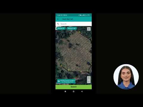
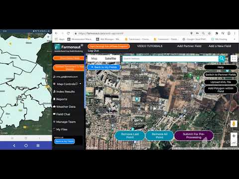
Field Mapping & Soil Sampling Analysis for Farmers
Field mapping for farmers is the cornerstone of precision farming. With GPS-powered devices and satellite data, we can create detailed digital maps of every parcel, capturing soil type, topography, and vegetation patterns. This approach ensures accurate soil sampling and analysis, enabling targeted input application.
- Pinpoint variations in nutrient levels, organic matter, or pH across your field.
- Customize fertilizer and irrigation plans for optimal crop growth.
- Eliminate repetitive or “blind” application of inputs, reducing waste and associated costs.
By integrating GPS field mapping into our practices, we promote sustainable agriculture—maximizing yields and minimizing risks associated with over-application.
-
Variable Rate Technology (VRT) in Farming
Variable rate technology in farming is revolutionizing how inputs—seeds, fertilizers, pesticides—are distributed across our farms. Guided by GPS data and precision maps, VRT-equipped machinery adjusts application rates in real-time.
- Apply only what material is needed in each field zone, reducing costs and environmental risk.
- Boost yield potential by meeting precise nutrient requirements—no more “one-size-fits-all”.
- Enhance environmental sustainability by avoiding runoff or leaching of chemicals beyond field boundaries.
By using VRT with reliable GPS guidance, we make inputs work harder and smarter, driving both profitability and resource conservation.
-
Automated Steering & Machinery Guidance
GPS tracking delivers unprecedented accuracy for guiding tractors and other farm machinery. Automated farm machinery systems enable our equipment to follow precise paths—down to a few centimeters—without the fatigue or error associated with manual driving.
- Reduce overlap during tasks like planting, spraying, or harvesting—no double coverage, no missed strips.
- Minimize soil compaction and wear by keeping machinery on predetermined paths (Controlled Traffic Farming, or CTF).
- Drive operational efficiency by extending working hours and reducing labor needs, especially during high-pressure seasons.
The synergy between GPS tracking, automated guidance, and CTF means we achieve flawless operations while preserving soil structure, reducing costs, and maximizing time use.
-
Crop Yield Monitoring & Mapping
GPS integration enables continuous crop yield monitoring at harvest. Onboard sensors in harvesters correlate yield and moisture data with precise field locations, building high-resolution yield maps.
- Visualize yield variability across the entire field—even within a single pass.
- Identify underperforming areas, investigate root causes, and adapt management for the next season.
- Cross-reference with previous input application maps for powerful decision-making.

Yield maps are not just about record keeping—they are blueprints for continuous yield improvement through data-driven analysis.
-
Remote Crop Health Monitoring
With the fusion of GPS, satellites, and drones, we can monitor crop health remotely and in real time with unmatched accuracy. Variations in NDVI (Normalized Difference Vegetation Index), visible only to advanced sensors, flag areas of pest attack, water stress, or nutrient deficiency.
- Spot problems before they escalate—even in remote or hard-to-reach zones.
- Use precise location data to dispatch targeted interventions and optimize resource use.
- Improve crop resilience and profitability with timely, informed decisions.
Farmonaut’s monitoring platform, using affordable apps and APIs, puts advanced satellite crop monitoring within reach worldwide.
-
Controlled Traffic Farming (CTF)
Controlled Traffic Farming (CTF) restricts vehicle movement to permanent lanes, preserving the soil in actively cropped areas. GPS-enabled guidance systems and mapping ensure repeated accuracy year after year.
- Reduce soil compaction in zones where roots need to thrive for water and nutrient access.
- Enhance long-term soil health and water infiltration.
- Increase yield performance by promoting optimal root development and biological activity.
By implementing CTF, we not only protect our fields’ legacy but also create opportunities for cost savings and climate-smart farming.
-
Fleet, Asset & Resource Tracking for Agriculture
Our machinery—tractors, harvesters, sprayers—are significant investments. With real-time GPS tracking systems, we gain complete visibility over equipment usage, movement, and security.
- Optimize field operations and task allocation across multiple machines and teams.
- Reduce theft or misuse risks by monitoring exact locations 24/7.
- Streamline equipment deployment for fuel, time, and maintenance savings.
Learn more about comprehensive fleet management solutions at Farmonaut Fleet Management which enables tracking, scheduling, and optimizes machinery logistics for agribusinesses and large farms.
Impact of GPS Tracking on Key Farming Operations
To clearly highlight the power of GPS-enabled agriculture, let’s compare traditional versus GPS-based approaches across key operations.
| Farming Operation | Traditional Approach | GPS-Enabled Approach | Estimated Efficiency Improvement (%) | Estimated Cost Savings (%) |
|---|---|---|---|---|
| Field Mapping | Manual sketches, rough boundaries, limited detail | High-resolution mapping, accurate GPS boundaries | 20–30% | 10–20% |
| Crop Yield Monitoring | Visual estimates, incomplete records | Real-time yield, moisture, and spatial tracking | 10–20% | 5–10% |
| Fertilizer Application | Uniform application; risk of over/underuse | VRT, targeted to field-specific requirements | 15–25% | 10–20% |
| Irrigation Management | Fixed schedules; possible under/overwatering | Moisture sensors with GPS, data-driven planning | 15–30% | 10–25% |
| Harvest Timing | Based on observation or calendar | AI and yield map-driven decision-making | 10–15% | 5–12% |
These quantifiable improvements demonstrate why agriculture GPS tracking systems are no longer optional—but essential—to remain competitive and sustainable.
Main Benefits of GPS Tracking in Agriculture
Adopting GPS technology in agriculture unlocks a spectrum of business and sustainability advantages for farms of every size:
- Enhanced Efficiency and Productivity: Automated operations, data-driven management, and accurate inputs mean more work done in less time—with higher yields.
- Direct Cost Savings: Precision input application and efficient machinery use immediately reduce ongoing farm costs (seeds, fertilizers, labor, fuel, and repairs).
- Environmental Sustainability: By reducing over-application of agrochemicals and optimizing water use, GPS-guided operations support carbon footprint reduction and environmental compliance.
- Stronger Security: Asset tracking protects high-value equipment from theft and misuse, giving peace of mind and improved insurance compliance.
- Smarter, Informed Decisions: Consistent, location-based data delivers deep insights for crop management and strategic planning, guiding everything from resource allocation to product traceability.
For more on blockchain-based product traceability and supply chain transparency, see Farmonaut Traceability, ensuring proven origin and authenticity for agricultural goods.
Challenges and Considerations in Deploying GPS Technology in Agriculture
Despite its many advantages, adopting agriculture GPS tracking does present some hurdles—especially for smallholder and resource-limited farmers.
- Initial Investment & Training: New hardware, farm management software, and ongoing training are required for effective integration. Choosing affordable, scalable tools—like Farmonaut’s app-based platforms—reduces these barriers for farms worldwide.
- Connectivity Limitations: Certain remote regions may face weak GPS or internet coverage, impacting real-time updates or system calibration. Combining GPS with satellite connectivity and offline app features ensures continued access.
- Data Management: The volume of field and crop data can be overwhelming. Effective analysis requires robust management systems and sometimes outside expertise. Using AI-driven advisory platforms simplifies data interpretation and turns information into actionable insights.
To discover affordable, subscription-based solutions with AI advisory, real-time monitoring, and blockchain traceability, learn more about large-scale farm management through Farmonaut’s platforms.
Future Prospects: The Next Generation of GPS Tracking in Agriculture
As the agriculture technology landscape evolves, so does the potential of GPS tracking to drive innovation and sustainability across the sector.
1. Integration of Artificial Intelligence (AI) and Machine Learning
AI-powered analysis can predict yields, flag pest outbreaks, and recommend optimal planting and harvesting windows based on GPS-captured field conditions. Farmonaut’s Jeevn AI advisory system epitomizes this next-level automation and insight.
2. IoT & Connected Sensor Networks
Internet of Things (IoT) brings soil moisture probes, weather sensors, and machinery data into a centralized GPS-enabled platform, automating irrigation, crop health monitoring, and more—anytime, anywhere.
- Access real-time data from your smartphone, web dashboard, or via app API for deeper integration.
- For developers and agribusinesses, integrate satellite and weather data into your systems with Farmonaut’s API (Developer Docs).
3. Autonomous Machinery and Robotics
Innovations in autonomous tractors, drones, and field robots, guided by GPS, are set to transform labor management, optimize input application, and minimize human error—especially during planting and harvesting peaks.
Farmonaut: Affordable and Advanced Agriculture GPS Tracking Systems
Farmonaut is redefining what affordable precision farming means. As a global leader in satellite-based farm management, we offer advanced GPS solutions that are:
-
Accessible: Available on


or
 .
.
- Comprehensive: From remote crop health monitoring, soil moisture analysis, to fleet and resource management, all operations are fully integrated and data-driven.
- Smart & Scalable: AI-driven insights, blockchain-based product traceability, and customizable subscription plans to suit all—from individual growers to agribusinesses and governments.
Boost your eco-credentials with carbon monitoring or secure better crop loans and insurance using satellite-based farm verification.
To experience accessible, scalable, and effective agriculture GPS tracking, check out Farmonaut’s one-stop solutions:
FAQs – Agriculture GPS Tracking, Precision Farming & Farmonaut
-
What is agriculture GPS tracking and why is it important?
Agriculture GPS tracking uses satellite signals to pinpoint exact locations and movements of equipment, resources, and field boundaries. It forms the digital backbone of precision farming, optimizing everything from input usage to security and yields.
-
How does GPS technology help with crop yield monitoring?
By linking real-time harvest data (yield, moisture) with GPS, farmers generate precise yield maps. These reveal variations across the field, helping us adapt management practices, optimize inputs, and boost overall productivity.
-
What are the main benefits of variable rate technology in farming?
VRT allows for input application—seeds, fertilizers, pesticides—in precise quantities based on each area’s needs. This saves money, minimizes environmental impact, and promotes consistent, optimal crop growth.
-
Is Farmonaut suitable for small and medium farms?
Yes! Farmonaut makes precision agriculture affordable and accessible, regardless of farm size. Its user-friendly mobile and web platforms mean anyone can benefit from satellite-driven GPS solutions.
-
What equipment is needed for GPS tracking in agriculture?
Basic GPS tracking can use smartphones with accurate apps; advanced options utilize GPS-enabled equipment and integrated management platforms. Farmonaut only requires a smartphone or computer—no expensive, specialized hardware.
-
Can GPS technology in agriculture help with farm resource management?
Absolutely. Integrated GPS and data platforms—like Farmonaut—enable fleet and resource management, tracking every action and asset for greater field efficiency, cost reduction, and sustainability.
-
How can I start using Farmonaut for GPS-powered farming?
Download the Android app or iOS app, or sign in to the web app to create your farm, map fields, and access deep insights instantly.
-
Does Farmonaut offer integration or API access?
Yes—businesses can integrate Farmonaut’s satellite data, weather, and analytics into their own systems via the Farmonaut API. Developer documentation is also available.
Conclusion: Making Every Hectare Count with Agriculture GPS Tracking
Agriculture has entered an age where every decision can be data-driven, precise, and sustainable. By adopting GPS tracking systems, we not only increase productivity and profits but also safeguard the long-term health of our resources and ecosystems. Farmonaut’s advanced yet affordable platforms lead this technological revolution—democratizing access to precision farming for farmers everywhere.
Whether you manage a single hectare or vast commercial fields, incorporating GPS technology in agriculture empowers us to make every hectare count—and every action more effective than ever before.


