
GPS in Agriculture: 7 Shocking Ways to Boost Yields
Table of Contents
- Introduction
- Did You Know?
- GPS Technology in Agriculture: Transforming Precision Farming
- Comparative Benefits Table: GPS Applications in Agriculture
- 1. Precision Planting and Field Mapping for Farmers
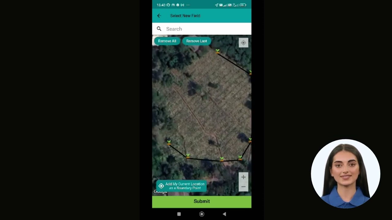
- Image: GPS in Agriculture
- 2. Automated Guidance and Steering Systems
- Video: Satellite Revolution in Agriculture
- 3. Variable Rate Application (VRA) for Smarter Resource Use
- 4. Yield Monitoring Systems and Data Analysis
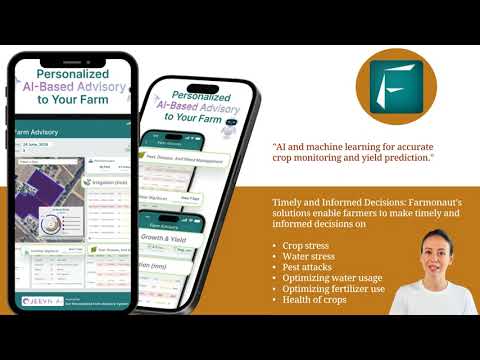
- Video: Farmonaut’s Crop Monitoring & Yield Prediction
- 5. GPS-Enabled Soil Sampling and Nutrient Management
- 6. Precision Irrigation Management in Farming
- Image: GPS Yield Boosts
- 7. Livestock Tracking & Geofencing for Optimized Grazing
- Midway Trivia
- Farmonaut: Making Precision Agriculture Accessible
- How GPS Technology Powers Sustainable Farming Practices
- Challenges and Considerations with GPS in Agriculture
- Future Prospects: Integrating GPS with Next-Gen AgriTech
- Try Farmonaut’s Advanced Precision Agriculture Solutions
- FAQs about GPS in Agriculture
- Final Words: Revolutionizing Agriculture with GPS Technology
Introduction
In today’s fast-paced agricultural landscape, GPS technology in agriculture has rapidly become an indispensable tool for farmers seeking to revolutionize their field operations, enhance yields, and embrace truly precision farming. From field mapping and variable rate application (VRA) to automated guidance systems and advanced soil nutrient management, the integration of GPS and related technologies is powering one of the greatest transformations in modern farming history.
At Farmonaut, we have witnessed how the adoption of accurate positioning systems has enabled millions of growers to optimize the use of resources, reduce waste, and make informed data-driven decisions. This comprehensive guide will take you through seven shocking, evidence-backed ways—supported by powerful imagery and real-world data—in which GPS is boosting yields and driving sustainability in agriculture worldwide.
“Precision GPS in agriculture can reduce fertilizer use by up to 30%, significantly lowering costs and environmental impact.”
GPS Technology in Agriculture: Transforming Precision Farming
For centuries, farmers relied on intuition, experience, and basic tools to manage their fields. Today, with the advent of advanced Global Positioning System (GPS) solutions, we can accurately delineate field boundaries, analyze topographical variations, and implement practices that optimize every inch of cropland.
At its core, GPS technology in agriculture offers:
- Sub-meter and even centimeter-level accuracy for critical farm operations
- Real-time data collection for yield monitoring, resource management, and field mapping for farmers
- Integration with farm machinery for automated guidance and steering systems
- Empowerment of variable rate application (VRA) and optimized input utilization
- Enhanced ability to embrace sustainable farming practices and reduce environmental impact
Let’s take a data-driven journey through seven actionable applications that illustrate how GPS is revolutionizing every aspect of the agricultural value chain.
Comparative Benefits Table of GPS Applications in Agriculture
| GPS Technology/ Application |
Description | Estimated Yield Increase (%) | Resource Efficiency Gain (%) | Key Benefit |
|---|---|---|---|---|
| Field Mapping | Accurately delineating field boundaries and variability for tailored management | 15-20 | 20-25 | Optimized planting, input allocation, and minimized field overlap |
| Variable Rate Application (VRA) | Applying seeds, fertilizers, and pesticides precisely where needed | 10-18 | 15-30 | Reduced input waste and improved crop health |
| Precision Planting | Uniform seed depth, spacing, and placement for even emergence | 5-12 | 8-17 | Consistent crop stands, improved yields |
| Automated Guidance | GPS-enabled machinery navigation for reduced overlaps and accurate paths | 5-10 | 10-22 | Lower fuel/operational costs, less operator fatigue |
| Livestock Tracking | Monitoring animal location, health, and grazing efficiency | 2-7 | 10-15 | Better herd management, optimized grazing |
| Crop Monitoring | Real-time yield, plant health, and soil status data via GPS-linked systems | 12-25 | 18-32 | Early issue identification, targeted treatments |
| Geofencing | Virtual field boundaries for equipment control and data precision | 4-8 | 7-12 | Enhanced field operations, better tracking |
1. Precision Planting and Field Mapping for Farmers
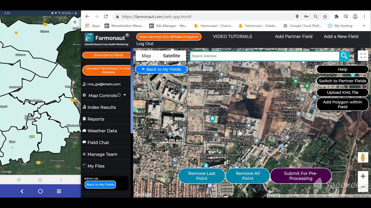
One of the most transformative applications of GPS technology in agriculture is the ability to generate detailed field maps, accurately delineating boundaries, soil types, and subtle topographical variations. By leveraging these precision agriculture solutions, we as farmers can make targeted management decisions that directly influence crop yields and financial returns.
- Accurate Field Mapping: With GPS receivers mounted on vehicles or handheld devices, we can walk field perimeters and record precise coordinates, creating digital maps of our farms.
- Understanding Field Variability: By layering soil type, previous yield data, and topographical changes over these maps, we see how different areas of the field require unique crop management approaches.
- Optimized Seed Placement: These maps allow us to customize planting strategies by zone—adjusting seed depth, spacing, and population rates for optimal crop emergence and uniform growth.
This targeted approach ensures every inch of land is used effectively, and seed investment is transformed into productive yield. Not only does this further sustainable farming practices by maximizing resource utilization, it also enables us to respond dynamically to in-field variability—a key advantage over traditional blanket farming methods.
Want to start field mapping with your smartphone? Try the Farmonaut App’s mapping capability, making field boundary digitization and management simple and affordable for every farmer across regions—direct from your Android, iOS, or browser device.


2. Automated Guidance and Steering Systems
GPS-guided automated steering systems are redefining the way we operate agricultural machinery. By integrating accurate navigation into tractors, planters, and sprayers, farmers can now achieve unmatched efficiency and precision in everyday fieldwork.
- Precise Navigation, Minimal Overlap: Automated steering uses GPS data to keep machines on pre-determined paths with sub-inch accuracy—eliminating plant skips and reducing harmful compression of soil between rows.
- Reduced Operator Fatigue: When GPS systems take over repetitive steering tasks, operators experience less physical and mental strain, leading to longer, safer, and more consistent workdays.
- Operational Savings: With less input overlap and optimal path planning, we see significant savings in fuel consumption, input costs, and total passes required—to the benefit of our wallets and the environment.
Many modern platforms, like Farmonaut’s, enable us to track machine routes, ensure proper field coverage, and generate real-time reports on resource utilization—all at a fraction of the cost of traditional precision farming systems.
Need efficient machinery management?
Explore Farmonaut Fleet Management, a GPS-enabled solution for real-time vehicle optimization, logistics safety, and reduced operational overhead.
3. Variable Rate Application (VRA) for Smarter Resource Use
Perhaps one of the most impactful innovations in precision agriculture solutions is the variable rate application (VRA) of critical farm inputs such as fertilizers, pesticides, and herbicides—guided by detailed GPS and sensor data.
How does VRA work for us as farmers?
- Field Zoning via Data Analysis: We use satellite imagery and soil sensors (often via platforms like Farmonaut) to divide fields into zones based on soil health, nutrient levels, past yields, and micro-climatic differences.
- Targeted Input Application: Tractors equipped with GPS-linked rate controllers vary application rates on-the-go, ensuring each zone receives just what it needs and no more.
- Waste Reduction: This approach directly tackles waste by minimizing over-application and runoff, supporting environmental sustainability and cost savings.
Studies show VRA (empowered by high-precision positioning systems) can increase average yields by 10–18%, while cutting chemical inputs (and potential environmental impact) by up to 30%. This is precision farming at its peak—aligned with both productivity and stewardship goals.
“Field mapping with GPS technology can increase crop yields by as much as 20% through optimized planting and resource allocation.”
Are you a developer or enterprise seeking to integrate GPS-powered data?
Access the Farmonaut Satellite & Weather API and API Developer Docs for real-time farm data, satellite imagery, and precision insights into your own agri-apps and research platforms.
4. Yield Monitoring Systems and Data Analysis
Yield monitoring systems powered by GPS allow us to track crop yields in real time during harvest, providing a wealth of actionable data for both current and future decision-making.
- Yield Mapping: By collecting geo-tagged yield data as the combine harvests different areas of the field, we create detailed digital yield maps that highlight spatial performance differences.
- Identifying Patterns: These maps often reveal high- and low-performing zones; with further analyzing, we uncover whether issues are due to variability in soil, nutrient imbalances, drainage challenges, or pest pressure.
- Enabling Data-Driven Strategies: We use historical yield data to refine our planting, soil management, and crop rotation strategies—pursuing consistently higher yields with less waste.
Linking GPS-based yield monitoring systems with satellite-driven crop health monitoring (as offered by Farmonaut) provides end-to-end intelligence for every phase of the crop cycle.
Desire real-time yield and health insights? Discover Farmonaut’s advanced crop monitoring—using satellite imagery (NDVI, EVI, True Color, Soil Moisture) and AI for actionable, GPS-specific recommendations on every parcel of your farm.
5. GPS-Enabled Soil Sampling and Nutrient Management
Soil nutrient management is a cornerstone of productive farming. Using GPS for precise soil sampling enables us to develop highly tailored fertilization plans.
- Targeted Sampling Locations: GPS is used to log and revisit specific sampling points, ensuring consistency and accuracy in data over time.
- Representative Data Collection: By aligning sample sites with mapped zones of soil type or past yield variability, we get a complete picture of in-field nutrient needs.
- Optimized Fertilizer Application: Using the data, we can apply nutrients where and when they’re needed, avoiding blanket applications that lead to waste.
This approach boosts productivity, promotes good soil health, and supports sustainable farming practices across all agricultural landscapes.
Looking to optimize your soil and crop health for plantations or forests?
Check out Farmonaut’s Crop Plantation & Forest Advisory, empowering accurate soil monitoring, GPS-guided input management, and data-driven advisory at scale.
6. Precision Irrigation Management in Farming
Irrigation management in farming is one of the most resource-costly components for many of us. Optimizing water use is imperative for sustainability, especially in regions facing water scarcity. GPS, when combined with GIS and satellite data, delivers dramatic improvements:
- Mapping Moisture Zones: We use moisture sensors and satellite-driven soil maps (often available via Farmonaut) to identify uneven irrigation needs across the field.
- Designing Efficient Systems: GPS helps us layout drip lines, pivots, and irrigation networks to deliver water precisely to critical areas, minimizing over-irrigation and runoff.
- Real-Time Adjustment: By analyzing location-based weather and crop growth data, we can automate adjustments for maximum resource efficiency.
The resulting savings—in both water and cost—are substantial and crucial for maintaining the environmental sustainability of farm operations.
Managing irrigation across vast holdings? Experience Farmonaut Large Scale Farm Management, a powerful tool for administrators and managers to monitor, analyze, and optimize water application and resource use efficiently.

7. Livestock Tracking & Geofencing for Optimized Grazing
While crop growers have seen significant benefits, livestock managers too are revolutionizing their practices through GPS—especially with wearable tags and collars for tracking and monitoring.
- Animal Location & Health: GPS trackers provide real-time data on the whereabouts of every animal in the herd, greatly improving management efficiency.
- Grazing Optimization: By analyzing animal movements and grazing patterns, we can change paddock sizes, set up geofences, and balance field usage—promoting soil health and high-quality forage.
- Safety & Security: GPS alerts notify us of animals leaving defined areas, reducing risk of loss or livestock theft.
These GPS-centric solutions allow us to address both the productivity and welfare needs of our operations, making them critical components of modern, sustainable livestock management.
“Field mapping with GPS technology can increase crop yields by as much as 20% through optimized planting and resource allocation.”
Farmonaut: Making Precision Agriculture Accessible
While GPS and precision agriculture systems were once considered an expensive luxury, digital agriculture platforms have democratized access for farmers worldwide. At Farmonaut, our mission is to provide reliable, data-driven farm management, mapping, and advisory tools regardless of location or scale.
Our Approach to GPS-Powered Solutions:
- Satellite-Based Crop Health Monitoring: We harness multispectral satellite imagery to deliver detailed crop health, soil moisture, and field variability maps for timely decision-making.
- Jeevn AI Advisory System: Personalized, real-time recommendations based on current field status, weather, and satellite data, helping us optimize every agronomy and resource decision.
- Blockchain-Based Product Traceability: Ensure full transparency from farm to fork, leveraging GPS-linked data logs—increasing trust and reducing fraud in agricultural value chains. Read more about Farmonaut Traceability tools.
- Fleet & Resource Management: Empowering agribusinesses to track, schedule, and optimize vehicle and resource usage for greater efficiency and cost reduction.
- Carbon Footprinting: Our systems generate real-time carbon emissions data, allowing farms and agri-businesses to monitor and manage their environmental impact. Learn about Farmonaut’s Carbon Footprinting.
By offering affordable subscriptions, easy app-based interfaces, and API access, Farmonaut ensures precision farming is within reach for all farmers—from smallholders to large agri-corporations, government units, and NGOs.
How GPS Technology Powers Sustainable Farming Practices
The heart of true sustainable farming practices lies in maximizing production with minimal waste and environmental degradation. GPS-based systems directly support this goal by:
- Reducing Chemical Runoff: With precise VRA, only the necessary amount of fertilizer or pesticide is applied, significantly reducing the risk of contamination to water sources and non-target organisms.
- Promoting Healthy Soil: Targeted management of fields reduces compaction, erosion, and overuse of inputs, supporting long-term soil health.
- Optimizing Water Use: Efficient, GPS-guided irrigation ensures every drop is effectively delivered, ensuring resilience amid increasing climate stress.
- Lowering Carbon Footprint: Fewer machinery passes, coupled with sustainable input application, reduce emissions and overall footprint—vital for modern environmental regulations.
Interested in tracking and lowering your farm’s carbon footprint?
See how Farmonaut Carbon Footprinting can help your operation stand out for environmental responsibility and regulatory compliance.

Challenges and Considerations with GPS in Agriculture
While the promise of GPS technology in agriculture is immense, a few challenges remain that we, as practitioners and stakeholders, must consider:
- Initial Investment: The upfront cost of acquiring GPS equipment and compatible machines (while decreasing) can still be a barrier, especially for the smallest operations.
- Technical Barriers: Signal interference (from tree cover or tall crops) and the need for skilled operator training can impact the accuracy and reliability of GPS-driven tasks.
- Data Security & Privacy: With increasing use of data-driven management, the responsibility to protect sensitive farm and operational data is greater than ever.
- Scaling and Customization: Technology must be adaptable to diverse crops, regions, and regulatory standards, especially as farming practices vary widely across different locations.
Fortunately, digital-first platforms (like Farmonaut) reduce these friction points by accelerating training, offering affordable subscription models, and ensuring best-in-class data security.
Concerned about financial risks or need better access to agri-loans & insurance?
Utilize Farmonaut’s Satellite-Based Crop Loan & Insurance Verification to streamline credit and insurance approvals with robust, fraud-resistant GPS-enabled verification.
Future Prospects: Integrating GPS with Next-Gen AgriTech
The journey of GPS technology in agriculture doesn’t end here. As we look forward, several trends are set to redefine the very nature of precision farming:
- Integration with IoT Devices: Real-time sensor data—temperature, soil moisture, in-field cameras—will provide even richer insight when geo-tagged with GPS, offering truly dynamic farm management.
- AI-Driven Analytics: With machine learning, massive data sets are processed into actionable recommendations, allowing us to optimize every aspect of the crop cycle.
- Blockchain-Based Traceability: By linking GPS events with blockchain logs, we guarantee transparency and authenticity for every product batch, boosting consumer trust and food safety.
- Autonomous Machinery: Tractors, drones, and harvesters will work independently, guided by highly accurate GPS, executing field tasks with unparalleled efficiency.
At Farmonaut, we embrace these technologies, making sure each new breakthrough serves to further empower the global farming community—improving yields, resource use, and environmental stewardship in tangible, measurable ways.
Try Farmonaut’s Advanced Precision Agriculture Solutions
FAQs about GPS in Agriculture
How does GPS improve crop yields in agriculture?
GPS enhances crop yields by providing precise field mapping, enabling uniform seed placement, guiding automated equipment to prevent overlaps and skips, and supporting targeted resource application such as fertilizer and water. This leads to optimized plant growth and maximized production in each zone of the field.
What is variable rate application (VRA) and why is it important?
VRA involves using GPS data and field sensors to apply farm inputs (like fertilizers, pesticides, or water) at different rates across distinct zones within a field, based on specific crop, soil, or environmental needs. This targeted approach boosts yield and resource efficiency while minimizing waste and environmental impact.
Can small-scale farmers benefit from precision agriculture solutions?
Absolutely! Modern platforms like Farmonaut have made GPS and satellite-powered precision farming accessible and affordable regardless of farm size. Using smartphone or mobile apps, even smallholders can monitor crop health, create field maps, and get AI-driven advisory at a low cost.
How does GPS technology contribute to sustainable farming practices?
By minimizing overuse of resources, encouraging targeted input application, reducing soil degradation and chemical runoff, and enabling better irrigation management, GPS technology supports the triple bottom line of sustainability: economic, environmental, and social.
Is GPS data secure and private when using platforms like Farmonaut?
Farmonaut implements industry-best practices for data security and privacy, ensuring that farmers’ data, field maps, and operational details remain secure. Blockchain-based modules are available for high-trust traceability where needed.
Where can I get started with GPS-powered precision agriculture?
Download the Farmonaut app for your mobile or web device to experience field mapping, crop monitoring, fleet management, and advisory—all powered by GPS and the world’s most advanced satellite sensors.
Final Words: Revolutionizing Agriculture with GPS Technology
As we embrace the digital revolution in farming, GPS technology in agriculture is more than a convenience; it’s the foundation of our ability to meet rising food demand, operate sustainably, and maximize every drop of water, every seed, and every hour invested. With trusted partners like Farmonaut, we can harness these tools to guide us into an era of productive, profitable, and environmentally responsible agriculture.
The time to adopt precision farming is now—let’s move forward together, harnessing the power of GPS and advanced data systems to transform every field, every season, for the better.
Explore, innovate, and thrive with precision agriculture solutions—Start with Farmonaut today!


