
Revolutionizing Precision Agriculture: How Farmonaut’s Advanced GNSS Technology Enhances Crop Mapping and Monitoring
“Advanced GNSS receivers support multiple satellite constellations, including GPS, GLONASS, and Galileo, enhancing precision in challenging environments.”
In the ever-evolving landscape of agriculture, precision and efficiency have become paramount. At Farmonaut, we are at the forefront of this agricultural revolution, harnessing the power of advanced Global Navigation Satellite System (GNSS) technology to transform the way farmers map and monitor their crops. Our cutting-edge solutions are not just changing the game; they’re redefining it entirely.
As we delve into the world of precision agriculture, it’s crucial to understand how GNSS technology is revolutionizing the industry. From construction sites to archaeological digs, from vast farmlands to intricate GIS mapping projects, the applications of this technology are as diverse as they are impactful.
The Evolution of GNSS Technology in Agriculture
The journey of GNSS technology in agriculture has been nothing short of remarkable. What started as a simple tool for navigation has evolved into a sophisticated system that provides unparalleled precision and reliability for professionals working in challenging environments. At Farmonaut, we’ve been at the forefront of this evolution, constantly pushing the boundaries of what’s possible with satellite-based technology.
Our advanced GNSS receivers are a testament to this progress. These compact and lightweight devices support multiple satellite constellations, including GPS, GLONASS, Galileo, BeiDou, IRNSS, QZSS, and SBAS. This multi-constellation support ensures that our users have access to the most comprehensive and accurate positioning data available, even in areas where traditional GPS might falter.
Farmonaut’s Advanced GNSS Technology: A Game-Changer for Precision Agriculture
At the heart of Farmonaut’s offerings is our state-of-the-art GNSS technology, specifically designed to meet the unique challenges of precision agriculture. Our system goes beyond simple positioning to provide a comprehensive suite of tools for crop mapping and monitoring.
- High-Precision Mapping: Our GNSS receivers offer centimeter-level accuracy, allowing farmers to create detailed maps of their fields, including topography, soil types, and crop boundaries.
- Real-Time Crop Monitoring: By integrating GNSS data with satellite imagery and on-ground sensors, we provide real-time insights into crop health, growth stages, and potential issues.
- Efficient Resource Management: Precise location data enables targeted application of resources like water, fertilizers, and pesticides, reducing waste and environmental impact.
- Automated Guidance Systems: Our GNSS technology powers automated steering systems for farm equipment, ensuring precise and efficient field operations.
These capabilities are not just theoretical; they’re making a real difference in the fields every day. Farmers using Farmonaut’s GNSS technology report significant improvements in crop yields, reduced input costs, and more sustainable farming practices.

Advanced Features of Farmonaut’s GNSS Technology
What sets Farmonaut’s GNSS technology apart is not just its precision, but also its advanced features designed to overcome common challenges in agricultural environments. Let’s explore some of these innovative capabilities:
Tilt Compensation and IMU Integration
One of the standout features of our GNSS receivers is the advanced tilt compensation technology. This includes a calibration-free and magnetic interference-immune integrated Inertial Measurement Unit (IMU). This means that even when the receiver is not perfectly level – a common scenario in rugged agricultural terrains – it can still provide accurate measurements.
The ability to work at tilts of up to 60 degrees is a game-changer for farmers. It allows for precise measurements in situations where traditional GNSS receivers would struggle, such as on steep hillsides or in areas with dense vegetation that might obstruct a clear view of the sky.
Signal Integrity Protection
In an age where data reliability is crucial, our GNSS technology incorporates sophisticated signal integrity protection. This includes anti-jamming and anti-spoofing features, ensuring that the data you receive is not only accurate but also secure from potential interference or manipulation.
For farmers, this means peace of mind. Whether you’re using our system for automated guidance of farm equipment or for precise crop monitoring, you can trust that the data driving your decisions is reliable and protected.
RTK Correction Services
To further enhance precision, our GNSS receivers are compatible with Real-Time Kinematic (RTK) correction services. This technology allows for centimeter-level accuracy in real-time, a crucial feature for applications like precision planting or targeted nutrient application.
By integrating RTK correction, Farmonaut ensures that farmers have access to the most precise positioning data available, enabling them to make informed decisions and implement precise farming practices with confidence.

Applications of Farmonaut’s GNSS Technology in Agriculture
The applications of our advanced GNSS technology in agriculture are vast and varied. Here are some key areas where Farmonaut is making a significant impact:
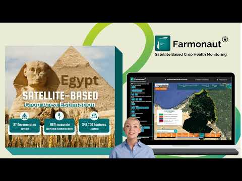
Precision Crop Mapping
Our GNSS technology enables farmers to create highly accurate maps of their fields. This includes detailed information on field boundaries, soil types, topography, and even micro-climates within the field. These maps serve as the foundation for precision agriculture practices, allowing for targeted interventions and optimized resource allocation.
Variable Rate Application
By combining GNSS data with soil maps and crop health information, farmers can implement variable rate application of inputs like fertilizers, pesticides, and water. This targeted approach not only reduces waste but also optimizes crop growth and yield.
Automated Guidance Systems
Our GNSS technology powers automated steering systems for tractors and other farm equipment. This results in more precise field operations, reducing overlap and gaps in planting, spraying, and harvesting. The result is improved efficiency, reduced fuel consumption, and less operator fatigue.
Yield Mapping
During harvest, our GNSS-enabled systems can create detailed yield maps, providing insights into field productivity variations. This information is invaluable for planning future crop rotations, identifying areas that may need additional attention, and optimizing overall farm management strategies.
The Farmonaut Advantage: Integrating GNSS with Satellite Imagery and AI
While our GNSS technology is powerful on its own, what truly sets Farmonaut apart is our integration of this technology with satellite imagery and artificial intelligence. This combination creates a comprehensive farm management solution that goes beyond simple positioning.
Satellite-Based Crop Health Monitoring
By combining GNSS data with multispectral satellite imagery, we provide farmers with real-time insights into crop health. Our system calculates vegetation indices like NDVI (Normalized Difference Vegetation Index), giving farmers a clear picture of crop vigor and potential issues before they become visible to the naked eye.
AI-Powered Advisory System
Our Jeevn AI advisory system takes the data from GNSS and satellite imagery and combines it with weather forecasts, historical data, and expert knowledge to provide personalized recommendations. This could include optimal planting dates, irrigation schedules, or pest management strategies tailored to specific field conditions.
Blockchain-Based Traceability
For farmers looking to add value to their products, our blockchain-based traceability solution integrates GNSS data to provide a verifiable record of a crop’s journey from field to consumer. This transparency can be a powerful marketing tool and a way to build consumer trust.
“Modern GNSS technology integrates tilt compensation and RTK correction services, revolutionizing high-precision GIS mapping and archaeological fieldwork.”
Comparing Farmonaut’s GNSS Technology with Traditional Methods
To truly appreciate the advancements that Farmonaut’s GNSS technology brings to precision agriculture, it’s helpful to compare it with traditional mapping and monitoring methods. The following table highlights key differences:
| Feature/Aspect | Traditional Methods | Farmonaut’s GNSS Technology |
|---|---|---|
| Precision level | Meter-level accuracy | Centimeter-level accuracy |
| Satellite constellations supported | Often limited to GPS | Multiple (GPS, GLONASS, Galileo, BeiDou, IRNSS, QZSS, SBAS) |
| Tilt compensation | Limited or none | Advanced, up to 60 degrees |
| Durability in harsh conditions | Variable | Rugged, water-resistant design |
| RTK correction services | Often not available | Integrated support |
| Signal integrity protection | Basic or none | Advanced anti-jamming and anti-spoofing features |
| Magnetic interference immunity | Susceptible to interference | Immune to magnetic interference |
| Anti-jamming capabilities | Limited | Advanced protection |
| Weight and portability | Often bulky | Compact and lightweight |
| Battery life | Variable | Extended for all-day operations |
As the table clearly demonstrates, Farmonaut’s GNSS technology offers significant advantages over traditional methods in every aspect. From precision and durability to advanced features like tilt compensation and signal integrity protection, our solution is designed to meet the demanding needs of modern precision agriculture.
Real-World Impact: Farmonaut’s GNSS Technology in Action
The true measure of any technology is its impact in real-world scenarios. Farmonaut’s GNSS technology has been making waves across various agricultural sectors, demonstrating its versatility and effectiveness. Here are some ways our technology is being applied:
Large-Scale Crop Monitoring
For large agricultural operations, our GNSS technology, combined with satellite imagery, provides a comprehensive view of vast areas. This enables efficient monitoring of crop health, early detection of issues, and optimal resource allocation across thousands of hectares.
Precision Viticulture
In the wine industry, where subtle variations in soil and microclimate can significantly impact grape quality, our high-precision GNSS mapping is revolutionizing vineyard management. Winemakers can now create detailed terroir maps, optimizing grape growing conditions with unprecedented accuracy.
Sustainable Farming Practices
By enabling precise application of inputs like water and fertilizers, our GNSS technology is helping farmers reduce their environmental footprint. This not only leads to cost savings but also promotes more sustainable farming practices.
Crop Insurance and Financing
The accurate field data provided by our GNSS technology is being used by financial institutions to verify crop conditions for insurance claims and loan approvals. This is helping to streamline processes and reduce fraud in agricultural financing.

The Future of GNSS Technology in Agriculture
As we look to the future, the potential for GNSS technology in agriculture continues to expand. At Farmonaut, we’re constantly innovating to stay ahead of the curve. Here are some exciting developments on the horizon:
Integration with IoT Devices
We’re working on seamless integration of our GNSS technology with Internet of Things (IoT) devices. This will create a network of interconnected sensors and machinery, all precisely geolocated, providing an even more comprehensive view of farm operations.
Enhanced AI Capabilities
Our AI systems are continuously learning and improving. Future versions of our technology will offer even more advanced predictive capabilities, helping farmers anticipate and prepare for challenges before they arise.
Improved Satellite Imagery Resolution
As satellite technology advances, we’re poised to integrate even higher resolution imagery into our systems. This will allow for even more detailed crop monitoring and analysis.
Expansion into New Agricultural Sectors
While our technology has already proven its worth in traditional crop farming, we’re excited about its potential applications in other areas of agriculture, such as precision livestock farming and aquaculture.

Accessing Farmonaut’s GNSS Technology
We believe in making advanced agricultural technology accessible to farmers of all scales. That’s why we offer multiple ways to access and utilize our GNSS technology:
Farmonaut Web App
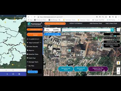
Our web application provides a user-friendly interface to access all of Farmonaut’s features, including our GNSS-powered mapping and monitoring tools. It’s designed for ease of use, allowing farmers to quickly gain insights into their operations.

Mobile Apps
For farmers on the go, our mobile apps for Android and iOS bring the power of Farmonaut’s GNSS technology right to your smartphone or tablet. Monitor your crops, receive alerts, and make decisions from anywhere in the field.


API Access
For developers and businesses looking to integrate Farmonaut’s GNSS and satellite data into their own systems, we offer comprehensive API access. This allows for custom solutions tailored to specific needs.
Earn With Farmonaut
Earn 20% recurring commission with Farmonaut’s affiliate program by sharing your promo code and helping farmers save 10%. Onboard 10 Elite farmers monthly to earn a minimum of $148,000 annually—start now and grow your income!
Learn More About Our Affiliate Program

Farmonaut Subscriptions
Conclusion: Embracing the Future of Precision Agriculture
As we’ve explored throughout this article, Farmonaut’s advanced GNSS technology is at the forefront of the precision agriculture revolution. By combining high-precision positioning with satellite imagery, AI-powered analytics, and user-friendly interfaces, we’re empowering farmers to make more informed decisions, optimize their operations, and embrace sustainable farming practices.
The future of agriculture is precision-driven, data-informed, and sustainably focused. With Farmonaut’s GNSS technology, that future is not just a possibility—it’s happening right now in fields across the globe. We invite you to join us in this agricultural revolution, whether you’re a small family farm or a large agricultural enterprise.
By embracing these advanced technologies, we can work together to meet the growing global demand for food while preserving our precious natural resources. The path to a more sustainable and productive agricultural future is clear, and it’s being mapped by Farmonaut’s advanced GNSS technology.
Frequently Asked Questions
- What is GNSS technology and how does it differ from GPS?
GNSS (Global Navigation Satellite System) is a broader term that encompasses various satellite navigation systems, including GPS (Global Positioning System). While GPS is operated by the United States, GNSS includes other systems like GLONASS (Russia), Galileo (European Union), and BeiDou (China). Farmonaut’s technology leverages multiple GNSS constellations for improved accuracy and reliability. - How accurate is Farmonaut’s GNSS technology?
Our GNSS technology offers centimeter-level accuracy, especially when used with RTK correction services. This high level of precision is crucial for applications like variable rate application and automated guidance systems. - Can Farmonaut’s GNSS technology work in areas with poor satellite coverage?
Yes, our technology is designed to work with multiple satellite constellations, which significantly improves coverage and reliability even in challenging environments. Additionally, our advanced tilt compensation allows for accurate measurements even when the receiver is not perfectly level. - How does Farmonaut integrate GNSS data with other farming technologies?
We integrate GNSS data with satellite imagery, weather data, and on-ground sensors to provide comprehensive farm management solutions. This data is processed by our AI systems to provide actionable insights and recommendations. - Is Farmonaut’s technology suitable for small farms?
Absolutely! We’ve designed our solutions to be scalable and accessible to farms of all sizes. Our user-friendly apps and flexible pricing options make precision agriculture technology available to small and medium-sized farms as well as large agricultural operations. - How does Farmonaut ensure data security and privacy?
We take data security very seriously. Our systems incorporate advanced signal integrity protection, including anti-jamming and anti-spoofing features. All data is encrypted and stored securely, and we adhere to strict privacy policies to protect our users’ information. - Can Farmonaut’s GNSS technology be integrated with existing farm equipment?
In many cases, yes. Our technology is designed to be compatible with a wide range of farm equipment. For specific integration questions, we recommend contacting our support team for detailed information about your particular setup. - How often is satellite imagery updated in Farmonaut’s system?
The frequency of satellite imagery updates can vary depending on the specific service package and geographical location. Generally, we provide updates every few days, but for the most up-to-date information, please check our current service offerings. - Does Farmonaut offer training on how to use its GNSS technology?
Yes, we provide comprehensive training resources including video tutorials, user guides, and webinars. Our support team is also available to assist users in getting the most out of our technology. - How does Farmonaut’s GNSS technology contribute to sustainable farming practices?
By enabling precise application of inputs like water, fertilizers, and pesticides, our technology helps reduce waste and minimize environmental impact. It also supports practices like targeted irrigation and variable rate application, which can significantly improve resource efficiency.
We hope this comprehensive guide has provided valuable insights into how Farmonaut’s advanced GNSS technology is revolutionizing precision agriculture. From crop mapping to real-time monitoring, our solutions are designed to empower farmers with the tools they need to thrive in the modern agricultural landscape. As we continue to innovate and expand our offerings, we remain committed to our mission of making precision agriculture accessible and beneficial for farmers worldwide.


