
Remote Sensing: 7 Shocking Secrets for Agri & Forestry
“Over 80% of global crop monitoring now relies on satellite-based remote sensing for real-time data.”
Introduction: Remote Sensing in Agriculture & Forestry
Remote sensing is driving a bold transformation across agriculture and forestry. As we collectively seek smarter, more sustainable food systems and environmental stewardship, the power of remote sensing data, satellite imagery, advanced sensors, and AI-driven analysis is more vital than ever. By equipping farmers, land managers, and policymakers with comprehensive, timely, and accurate information, we can manage resources more efficiently, optimize yields, and boost the overall health of our ecosystems.
The essence of remote sensing in agriculture lies in acquiring information about the Earth’s surface—without direct physical contact—using sophisticated tools like satellite imagery, aerial photography, and drone-based sensors. From monitoring crop health with NDVI indices to detecting water stress and forest degradation, these technologies have redefined our ability to manage land at scale.
Let’s dive deep into the 7 shocking secrets that make remote sensing the game-changer in modern farming and forest management. Along the way, we’ll highlight practical applications, reveal essential technologies, and show how platforms like Farmonaut offer cutting-edge solutions that put the power of data directly in your hands.


7 Shocking Secrets of Remote Sensing for Agri & Forestry
What makes remote sensing technologies truly revolutionary for agriculture and forestry? Here are the 7 most impactful applications—each one a key to unlocking more efficient, resilient, and sustainable land management.
1. Crop Monitoring and Health Assessment: NDVI Vegetation Health Analysis
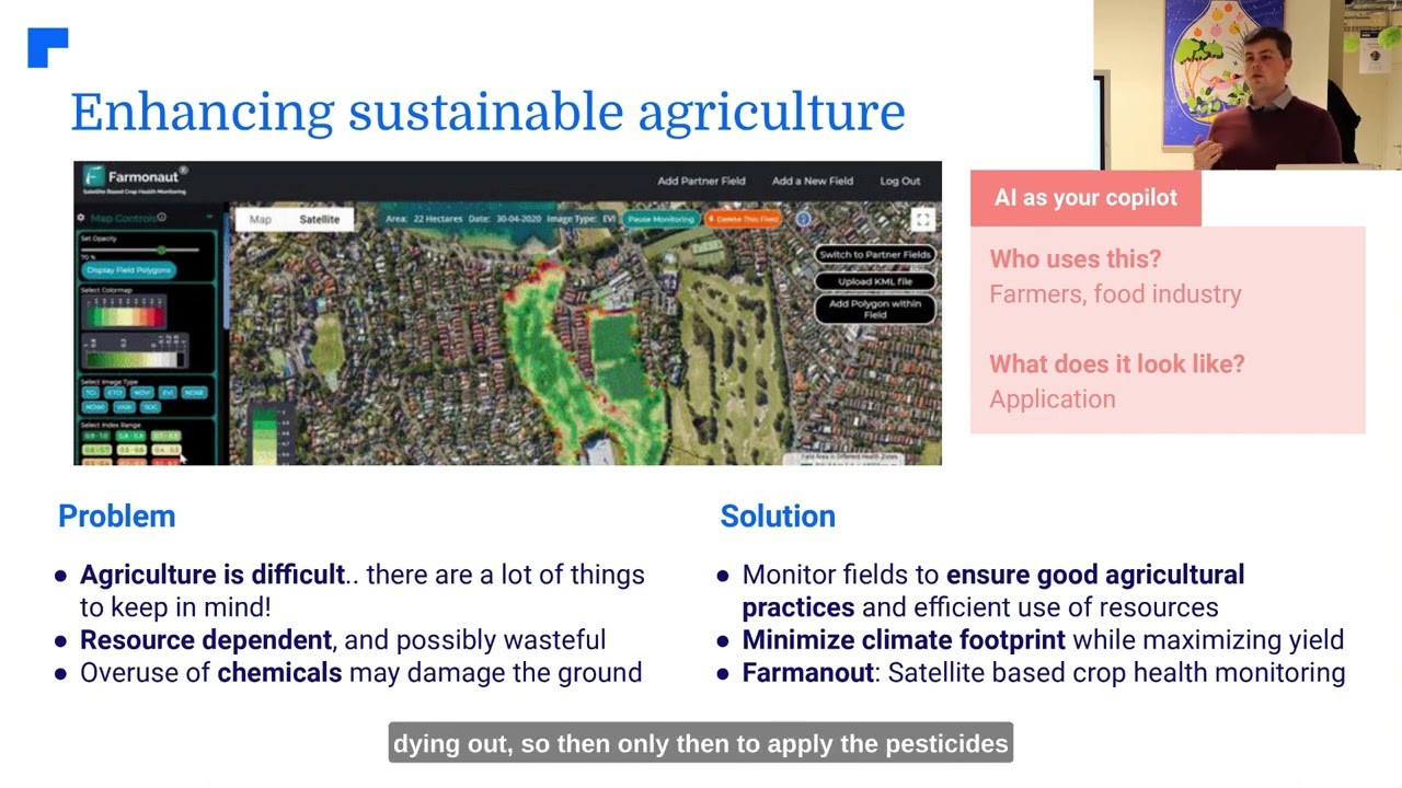
The cornerstone of remote sensing in agriculture is the ability to monitor crop health swiftly and accurately. By leveraging advanced satellite imagery and indices such as the Normalized Difference Vegetation Index (NDVI), farmers can visualize plant health, spot early stress signs, and precisely understand which fields require immediate action.
NDVI vegetation health analysis detects subtle changes in plant vigor—be it due to nutrient deficiencies, diseases, pests, or other stress factors. This proactive monitoring supports timely interventions such as targeted fertilizer application, pest management, and irrigation adjustments.
- Detect Stress & Losses Early: NDVI highlights inconsistent growth and stressed cells before symptoms are visible to the naked eye, reducing potential yield losses.
- Anomaly Detection: Quickly detect areas affected by diseases, pest infestations, or nutrient stress across large fields.
- Resource Optimization: Apply resources where they’re needed most, minimizing costs and environmental impact.
These insights drive both immediate decision-making and long-term strategic planning to ensure healthy, robust crops and improved yields.
Explore the Farmonaut API for NDVI and crop health data
2. Soil Mapping and Analysis: Soil Moisture Mapping
Effective soil management is at the heart of sustainable farming. Remote sensing technologies provide an innovative way to analyze spatial variations in soil properties—including moisture content, organic matter, and nutrient levels.
- Differentiated Soil Mapping: Create detailed soil maps that outline zones of varying fertility and texture for site-specific crop cultivation.
- Site-Specific Soil Management: Support precision farming by matching the right crops and inputs to each field’s characteristics.
- Optimal Planting Decisions: Increase yields, reduce environmental impact, and lower input costs with accurate soil analysis.
By analyzing data across seasons and years, farmers gain insights into long-term soil health trends, leading to improved yields and better resource allocation.
Want continuous and location-specific soil moisture insights?
Farmonaut’s Large-Scale Farm Management platform
offers specialized tools for multispectral mapping and soil moisture tracking, boosting decision-making at every step.


3. Water Resource Management in Farming: Efficient Irrigation & Stress Detection
Optimizing water use is critical in regions facing unpredictable rainfall or water scarcity. Remote sensing tools allow us to monitor soil moisture levels, rapidly detect water stress in plants, and plan responsive irrigation.
- Soil Moisture Detection: Monitor real-time soil moisture using multispectral imagery to prevent overwatering or underwatering—crucial for sustainable farming.
- Weather Forecast Integration: Combine satellite data with weather models, enabling farmers to plan tailored irrigation schedules.
- Water Conservation: Orderly allocation of water resources minimizes loss and supports environmental sustainability.
Using Farmonaut’s platform, farmers gain granular real-time water resource management—aiding not only yield optimization but also cost reduction and eco-friendly irrigation.
Advanced water monitoring supports targeted pest control and reduces carbon emissions by ensuring minimal resource wastage. Explore Farmonaut’s carbon footprinting tools for eco-smart farming!
4. Precision Farming Technologies: Integrating Satellite, GIS & AI
Precision farming technologies represent a seismic leap forward in efficient resource management. By integrating satellite imagery, GIS, GPS, and AI, we create “management zones” that allow for pinpoint application of fertilizers, pesticides, and irrigation.
- Variable Rate Technology: Apply fertilizers and pesticides at the right place and the right time—reducing input costs and environmental impact.
- Data-Driven Resource Allocation: Analyze historical and current data to optimize input strategies and mitigate crop losses.
- Custom Management: Split fields into unique zones, each with tailored interventions for improved yields and reduced waste.
Our ability to integrate sensors and decision-support systems offers unprecedented control—delivering sustainable gains in both farm profitability and environmental stewardship.
Want to automate and monitor large-scale input delivery? Check out Farmonaut’s fleet and resource management tools for smarter logistics and operational efficiency.
“Precision farming using remote sensing can boost yield prediction accuracy by up to 30% in agriculture and forestry.”
5. Yield Prediction and Estimation: Crop Monitoring & Yield Prediction Models
Using historical and real-time remote sensing data, we can now build sophisticated yield prediction models. These forecast not only the quantity but also the potential quality of harvests, empowering every stakeholder in the agricultural chain.
- Predictive Analytics: Use multispectral and temporal satellite imagery alongside weather data to project potential crop yields.
- Risk Management: Early detection of stress factors helps in timely interventions to mitigate losses and improve outcomes.
- Planning & Policy: Informs farmers, governments, and agribusinesses for effective resource allocation and market planning.
Want practical, field-specific yield projections? Use Farmonaut’s Crop Loan and Insurance solutions for verified, remotely-sensed yield estimates—streamlining financing and risk reduction.

6. Early Pest and Disease Detection: Targeted Interventions
Pests and diseases remain a persistent threat to global agriculture and forestry. Remote sensing systems excel at early detection by analyzing subtle changes in crop reflectance—a powerful jump ahead of manual scouting.
- Pest & Disease Surveillance: Automated alerts and maps flag outbreaks before they become large-scale epidemics.
- Intervention Precision: Deploy treatments only where needed, reducing chemical use and protecting beneficial flora/fauna.
- Yield Loss Mitigation: Immediate responses based on real-time monitoring minimize both lost income and environmental damage.
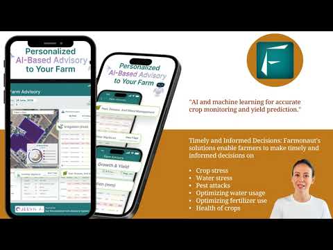
Farmonaut’s Jeevn AI advisory provides customized interventions and expert strategies for plant health protection, driven by ongoing satellite surveillance and machine learning analysis.
Visit Farmonaut’s Crop, Plantation, and Forest Advisory to leverage automated detection tools for every acreage.

7. Climate Risk Mitigation: Early Warning & Sustainable Planning
Climate volatility poses significant risks to both crops and forests. Remote sensing technologies serve as a first line of defense, providing early warnings of drought, flash floods, and severe weather events.
- Early Alerts: Automated warnings help farmers and foresters take action to protect assets and lives.
- Damage Assessment: High-resolution imagery supports rapid impact analysis for insurance claims and government response.
- Resilient Planning: Strategic insights support climate-smart agriculture, disaster preparation, and efficient recovery efforts.
Our tools for climate risk mitigation foster more resilient rural economies, safeguard livelihoods, and minimize the human and economic cost of environmental shocks.
Improve adaptation and sustainability with Farmonaut’s Carbon Footprinting solutions, offering real-time carbon emission tracking and mitigation planning for both farms and forests.
Comparison Table: Remote Sensing Applications in Agriculture vs. Forestry
| Application Area | Agriculture (Estimated Impact / Value) | Forestry (Estimated Impact / Value) |
|---|---|---|
| Crop Monitoring / Forest Stand Mapping | Up to 85% increase in monitoring efficiency; 30% reduction in manual scouting costs | Up to 80% improved accuracy in forest inventory; high-res mapping supports protected area planning |
| Yield Prediction | 30% improved forecast precision; faster access to yield insights for insurance/loans | Efficient estimation of wood volume, growth rates, carbon stock changes |
| Early Disease Detection | Decreased crop losses (20–40%) through targeted interventions | Rapid disease spread containment; eco-sensitive response strategies |
| Deforestation / Land Use Change Tracking | Land use analysis for compliance and expansion | Near real-time alerts for illegal deforestation; 95%+ detection accuracy |
| Resource & Water Management | 15–30% reduction in water and fertilizer use; supports drought response | Optimized reforestation and controlled burning; water quality assessment |
| Precision Spraying / Silviculture | Targeted application of inputs; reduced chemical run-off | Targeted thinning/pruning supports biodiversity and forest health |
| Sustainability & Carbon Assessment | Track and lower farm carbon footprint; compliance with green standards | Quantify carbon sequestration for trading/offsets; monitor ecosystem services |
Farmonaut: Satellite-Based Solutions for Modern Agri & Forestry
As we continue advancing toward a data-driven agricultural era, Farmonaut stands out by making precision farming and forest management accessible for all. Our platform is accessible via Android, iOS, web, and API, bringing the power of satellite analytics and AI-driven advisory to every farm, plantation, or forest block.
Technologies That Transform Land Management:
- Satellite-Based Crop Health Monitoring: Real-time NDVI, soil moisture, and vegetation mapping for analyzing health, yields, and resource needs.
- Jeevn AI Advisory: Personalized insights, weather forecasts, and expert agronomic advice for every stage of the crop/forest lifecycle.
-
Blockchain-Based Product Traceability: Full transparency across supply chains—ensuring trust from farm to market.
Learn how Farmonaut Traceability strengthens your supply chain integrity. -
Fleet and Resource Management: Optimize machinery, labor, and energy use for large farms and plantations.
See how Farmonaut’s Fleet Management tools reduce operational costs. -
Carbon Footprinting: Quantify and reduce the environmental impact of your operations.
Track and mitigate your carbon emissions with Farmonaut’s unique dashboard.
Farmonaut uses a flexible subscription model to serve smallholders, agribusinesses, governments, and financial services. Our API access lets users and developers integrate satellite and weather data into any workflow.
Visit Farmonaut’s Large-Scale Farm Management solution for seamless, scalable monitoring and decision support.
Financial institutions can use Farmonaut for satellite-based crop loan and insurance verification—reducing fraud and increasing farmers’ access to vital finance.
Advantages of Remote Sensing in Agriculture and Forestry
Harnessing the power of remote sensing has uniquely transformed decision-making, efficiency, and sustainability in agriculture and forestry. Here’s how:
- Enhanced Decision-Making: We get accurate, up-to-date data for actionable choices in crop, soil, and forest management.
- Increased Efficiency: Automate monitoring of vast areas and reduce manual data collection and human errors, improving overall operational efficiency.
- Environmental Sustainability: By reducing fertilizer, water, and chemical inputs, our sustainable practices leave a lighter footprint on the land and promote long-term viability.
- Cost & Time Efficiency: Lower overheads through remote data acquisition and reduced field labor.
- Multispectral & Multitemporal Analysis: See what the eye cannot—diseases, water stress, soil variations—using comprehensive spectral bands and time series analysis.
- Disaster Management & Response: Leverage instant high-res imagery for quick disaster assessment, evacuation planning, and efficient recovery.
Challenges and Limitations of Remote Sensing
While remote sensing technologies are powerful, it is important for us to understand and address their challenges for successful adoption:
- Data Quality & Accuracy: Environmental factors—like cloud cover or haze—can degrade imagery, impacting the accuracy of derived data for decision-making.
- Cost & Accessibility: Although affordable platforms such as Farmonaut are bridging the gap, high initial investments and maintenance costs can limit access, especially for small-scale farmers.
- Technical Expertise: Learning to interpret complex satellite, sensor, and imagery data requires training and ongoing support.
- Integration Challenges: Combining remote sensing solutions with existing farm and forest management systems may be hindered by legacy tools and incompatible equipment.
- Data Management: The sheer volume of remote sensing data demands robust storage, analysis, and interpretation tools.
- Regulatory & Privacy: Aerial surveillance and data acquisition raise privacy and compliance questions that must be addressed as part of sound governance.
Farmonaut’s modular approach and user-first interfaces make integration simpler—while ongoing advancements and community training help to bridge technical gaps.
Future Prospects: The Next Era of Remote Sensing in Agri & Forestry
The urge for smarter, more sustainable agriculture and forestry will keep accelerating innovation in remote sensing technologies. Here’s what we can expect in the coming years:
- Higher-Resolution Sensors: Sharper, more frequent imagery—driven by new satellite constellations—will enable even finer-grained analysis and faster response.
- Advanced AI & Machine Learning: Automation will increase as AI-powered models handle everything from anomaly detection to yield forecasting and disease risk mitigation.
- Marketplace Integration: We expect more seamless connectivity between farm management apps, sensor systems, and finance/insurance platforms—putting the benefits of remote sensing directly in farmers’ hands.
- Scalable Sustainability: More accessible, cost-effective, and user-friendly tools will empower smallholders everywhere, driving global adoption of best practices.
Our collective progress rests on the shoulders of technology & innovation—and remote sensing will lie at the heart of this green revolution. Farmonaut is committed to pushing these boundaries, ensuring that science and sustainability walk hand in hand.
Frequently Asked Questions (FAQ)
What is remote sensing and how does it work in agriculture?
Remote sensing is the acquisition of data about the Earth’s surface without direct contact, typically through satellite imagery, drones, or aerial photography. In agriculture, it helps farmers assess crop health, soil conditions, and irrigation needs—all without stepping onto the field.
What is NDVI and why is it important for crop monitoring?
NDVI (Normalized Difference Vegetation Index) is an index derived from satellite and multispectral imagery. It provides a reliable measure of plant vitality, enabling early detection of stress, diseases, or nutrient deficiencies that affect yield.
How can I access Farmonaut’s remote sensing tools?
Farmonaut’s solutions are available through Android, iOS, and web applications, as well as via a robust API for custom integrations. Visit the Farmonaut app portal to get started.
What is the benefit of remote sensing for forestry?
In forestry, remote sensing supports forest inventory, deforestation tracking, fire monitoring, and carbon sequestration assessment. This enables data-driven conservation, compliance, and sustainable resource management.
How does Farmonaut contribute to environmental sustainability?
Farmonaut offers carbon footprint monitoring and advice for sustainable land management, helping farmers and landowners reduce inputs, increase yields, and comply with environmental standards.
Conclusion: The Essential Role of Remote Sensing
From timely crop monitoring and yield prediction to efficient water management and sustainable forest planning, remote sensing technologies have reshaped how we manage the land. By unlocking real-time, precise, and actionable data, we enable smarter resource allocation, improvements in productivity, and a clear path to sustainability.
At Farmonaut, we empower farmers, agribusinesses, and governments with scalable, affordable, and cutting-edge tools for crop and forest management. Whether you’re a smallholder wanting to reduce crop losses, a planner seeking climate mitigation tools, or a business leader focused on traceability—Farmonaut puts the power of data and AI in your hands.
Join us in embracing the future of remote sensing in agriculture and forestry. Explore our web and mobile apps or visit our API developer documentation for custom integrations.
Let’s grow a more productive, resilient, and sustainable world—together.


