
Revolutionizing Forest Management: How Satellite Technology is Transforming Sustainable Forestry Practices
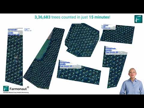
“Satellite-based forest monitoring can detect changes in forest cover as small as 10 square meters, enabling precise tracking of deforestation.”
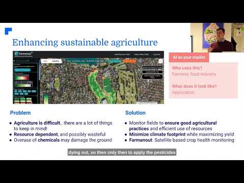
In the rapidly evolving world of environmental conservation and sustainable resource management, we are witnessing a remarkable transformation in how we approach forest management. At the forefront of this revolution is satellite technology, a powerful tool that is reshaping our ability to monitor, protect, and sustainably manage our planet’s vital forest resources. As pioneers in the field of agricultural technology, we at Farmonaut are excited to explore the cutting-edge advancements in forest monitoring technology and satellite-based forest management solutions that are driving this change.
Our journey into the world of advanced forestry analytics reveals how high-resolution satellite imagery is revolutionizing forest health assessment, deforestation tracking, and sustainable forest management practices. By leveraging the power of remote sensing and geospatial intelligence, we can now offer comprehensive monitoring of forest cover, conduct accurate biomass estimation, and perform detailed carbon stock analysis – all from the vantage point of space.

In this comprehensive exploration, we’ll delve into how these innovative solutions are being customized for various stakeholders, including government agencies, timber industry professionals, and environmental researchers. We’ll uncover the potential of satellite data in detecting illegal logging, assessing fire damage, and supporting critical reforestation efforts. Moreover, we’ll examine how this technology aids in tree species classification, vegetation health monitoring, and climate impact assessment.
As we navigate through the intricacies of this advanced forest monitoring system, we’ll discover how it’s driving data-informed decisions, enhancing sustainability practices, and contributing to global forest conservation initiatives. Join us as we explore the future of precision forestry and environmental stewardship, powered by the eyes in the sky.
The Evolution of Forest Monitoring: From Ground to Space
Traditional forest management techniques have long relied on ground-based surveys, manual data collection, and periodic assessments. While these methods have served us well, they come with limitations in terms of scale, frequency, and accuracy. The advent of satellite technology has ushered in a new era of forest monitoring, offering unprecedented capabilities that are transforming the field of forestry.
- Global Coverage: Satellites can monitor vast expanses of forest across continents, providing a truly global perspective on forest health and changes.
- Frequent Observations: With multiple satellite passes, we can now monitor forests on a daily or weekly basis, capturing rapid changes and enabling timely interventions.
- High-Resolution Imagery: Advanced sensors on satellites deliver incredibly detailed images, allowing for the identification of individual trees and small-scale changes in forest cover.
- Multi-Spectral Analysis: By capturing data across various spectral bands, satellites provide insights into forest health, species composition, and even soil moisture levels.
This technological leap forward has revolutionized our approach to forest management, offering tools and insights that were previously unimaginable. Let’s explore how these advancements are being applied in practice.
Comprehensive Forest Cover Monitoring
One of the most significant applications of satellite technology in forestry is the ability to monitor forest cover changes over time. This capability is crucial for tracking deforestation, assessing the success of reforestation projects, and understanding long-term trends in forest health.
- Deforestation Tracking: Satellite imagery allows us to detect and quantify forest loss with remarkable precision. By comparing images over time, we can identify areas of deforestation, even in remote or inaccessible regions.
- Reforestation Monitoring: Similarly, we can track the progress of reforestation efforts, measuring the growth and spread of new forest areas over months and years.
- Historical Analysis: With archives of satellite data stretching back decades, we can conduct historical analyses to understand long-term trends in forest cover and ecosystem health.
These monitoring capabilities provide invaluable data for policymakers, conservationists, and forest managers, enabling them to make informed decisions and target their efforts effectively.
Advanced Forest Health Assessment
Satellite technology offers powerful tools for assessing and monitoring forest health on a large scale. By analyzing various spectral bands and vegetation indices, we can gain insights into the overall vitality of forest ecosystems.
- Vegetation Health Indices: Metrics like the Normalized Difference Vegetation Index (NDVI) provide quantitative measures of forest health and vigor.
- Disease and Pest Detection: Changes in spectral signatures can indicate the presence of diseases or pest infestations, allowing for early intervention.
- Drought Stress Monitoring: Satellite data can reveal areas of forest experiencing drought stress, helping managers prioritize conservation efforts.
These advanced health assessment capabilities enable proactive management strategies, potentially preventing widespread forest damage and promoting resilience in the face of environmental challenges.
Biomass Estimation and Carbon Stock Analysis
In the context of climate change mitigation, accurate estimation of forest biomass and carbon stocks is crucial. Satellite technology provides innovative methods for these assessments:
- LiDAR Technology: Light Detection and Ranging (LiDAR) sensors on satellites can create detailed 3D models of forest structure, enabling accurate biomass estimation.
- Radar Imaging: Synthetic Aperture Radar (SAR) can penetrate cloud cover and forest canopies, providing data on forest structure and biomass even in challenging conditions.
- Machine Learning Algorithms: Advanced algorithms combine multiple data sources to improve the accuracy of biomass and carbon stock estimates.
These tools are invaluable for carbon accounting, supporting initiatives like REDD+ (Reducing Emissions from Deforestation and Forest Degradation), and informing climate policy decisions.
“High-resolution satellite imagery allows for the classification of over 100 different tree species, enhancing biodiversity assessment in forests.”
Customizable Solutions for Diverse Stakeholders
The power of satellite-based forest monitoring lies in its versatility and adaptability to different needs. At Farmonaut, we recognize the diverse requirements of various stakeholders in the forestry sector and offer customizable solutions to meet these needs.
- Government Agencies: Comprehensive monitoring tools for national forest inventories, policy enforcement, and conservation planning.
- Timber Industry: Precision forestry solutions for sustainable harvest planning, inventory management, and compliance monitoring.
- Environmental Researchers: Advanced analytics for biodiversity assessment, ecosystem studies, and climate change impact analysis.
- Conservation Organizations: Tools for protected area monitoring, wildlife habitat assessment, and conservation impact evaluation.
By tailoring our satellite-based solutions to the specific needs of each stakeholder group, we ensure that the power of this technology is harnessed effectively across the entire forestry sector.

Detecting Illegal Logging and Forest Degradation
One of the most challenging aspects of forest management is combating illegal logging and forest degradation. Satellite technology provides powerful tools for addressing these issues:
- Near Real-Time Monitoring: Frequent satellite passes allow for the detection of logging activities shortly after they occur.
- Change Detection Algorithms: Advanced algorithms can identify subtle changes in forest structure that may indicate selective logging or degradation.
- Integration with Alert Systems: Satellite data can be integrated with alert systems to notify authorities of potential illegal activities promptly.
These capabilities significantly enhance the ability of forest managers and law enforcement agencies to combat illegal logging and protect forest resources.
Fire Damage Assessment and Prevention
Forest fires pose a significant threat to ecosystems worldwide. Satellite technology plays a crucial role in both fire prevention and damage assessment:
- Fire Risk Mapping: By analyzing vegetation dryness, weather conditions, and historical data, satellites can help create fire risk maps to guide prevention efforts.
- Active Fire Detection: Thermal sensors on satellites can detect active fires, even in remote areas, enabling rapid response.
- Post-Fire Assessment: High-resolution imagery allows for detailed mapping of burn scars, helping to plan restoration efforts and assess ecological impact.
These tools are invaluable for fire management agencies, helping to minimize the devastating effects of forest fires on ecosystems and communities.
Supporting Reforestation and Restoration Efforts
Reforestation and ecosystem restoration are critical components of sustainable forest management. Satellite technology supports these efforts in several ways:
- Site Selection: Analysis of soil conditions, topography, and climate data helps identify optimal sites for reforestation projects.
- Progress Monitoring: Regular satellite imagery allows for the tracking of reforestation progress over time, ensuring the success of projects.
- Impact Assessment: Long-term monitoring helps evaluate the ecological impact of restoration efforts on biodiversity and ecosystem services.
These tools enable more effective planning and implementation of reforestation projects, maximizing their impact on forest conservation and climate change mitigation.
Tree Species Classification and Biodiversity Monitoring
Advanced satellite technology, combined with machine learning algorithms, is revolutionizing our ability to classify tree species and monitor forest biodiversity from space:
- Hyperspectral Imaging: Sensors that capture data across hundreds of spectral bands can distinguish between different tree species based on their unique spectral signatures.
- Seasonal Change Analysis: By monitoring changes in vegetation throughout the year, we can identify species based on their phenological patterns.
- Habitat Mapping: Detailed species classification enables the creation of high-resolution habitat maps, crucial for biodiversity conservation efforts.
These capabilities provide unprecedented insights into forest composition and biodiversity, supporting conservation planning and ecosystem management.
Climate Impact Assessment and Adaptation Planning
As climate change continues to affect forest ecosystems worldwide, satellite technology plays a crucial role in understanding these impacts and planning adaptation strategies:
- Long-Term Trend Analysis: Decades of satellite data allow us to track changes in forest health, composition, and distribution over time.
- Vulnerability Mapping: By combining climate projections with forest data, we can identify areas most at risk from climate change impacts.
- Adaptation Strategy Assessment: Satellite monitoring helps evaluate the effectiveness of various adaptation strategies, informing future management decisions.
These tools are essential for developing resilient forest management strategies in the face of a changing climate.

The Future of Precision Forestry
As we look to the future, the potential for satellite technology in forest management continues to expand. Emerging trends and technologies promise even more precise and powerful tools for sustainable forestry:
- AI and Machine Learning: Advanced algorithms will continue to improve the accuracy and speed of forest analysis, enabling near real-time monitoring and decision-making.
- Integration with IoT: Combining satellite data with ground-based sensors will provide even more detailed and localized forest information.
- Virtual and Augmented Reality: These technologies could revolutionize how we visualize and interact with forest data, enhancing planning and management processes.
As these technologies evolve, they will further enhance our ability to manage forests sustainably, protect biodiversity, and mitigate climate change impacts.
Comparison: Traditional vs. Satellite-Based Forest Management Techniques
| Aspect | Traditional Methods | Satellite-Based Methods |
|---|---|---|
| Data Collection Frequency | Monthly or Quarterly | Daily or Weekly |
| Area Coverage | Limited to accessible areas | Global coverage, including remote areas |
| Tree Species Identification | Manual, time-consuming | Automated, using spectral signatures |
| Deforestation Detection | Delayed, often after significant damage | Near real-time detection |
| Fire Damage Assessment | Post-event ground surveys | Real-time detection and rapid assessment |
| Carbon Stock Estimation | Sample-based, extrapolated | Comprehensive, data-driven estimates |
| Cost-Effectiveness | High labor and time costs | More cost-effective for large areas |
| Real-Time Monitoring | Limited to specific sites | Continuous, large-scale monitoring |
| Accuracy in Remote Areas | Often inaccessible or dangerous | Equal accuracy across all terrains |
| Integration with GIS | Manual data entry required | Seamless integration with GIS platforms |
Conclusion: Embracing the Satellite Revolution in Forestry
The integration of satellite technology into forest management represents a paradigm shift in how we approach the stewardship of our planet’s vital forest resources. From comprehensive monitoring and advanced health assessments to precise biomass estimation and biodiversity tracking, these tools are empowering foresters, conservationists, and policymakers with unprecedented insights and capabilities.
At Farmonaut, we are committed to harnessing the power of this technology to drive sustainable forest management practices. Our advanced forestry analytics platform offers customizable solutions that cater to the diverse needs of stakeholders across the forestry sector. By leveraging high-resolution satellite imagery, AI-driven analysis, and user-friendly interfaces, we’re making precision forestry accessible and actionable for users worldwide.
As we face the challenges of climate change, biodiversity loss, and increasing demands on our forest resources, the role of satellite technology in forest management will only grow in importance. By embracing these innovative tools and approaches, we can work towards a future where our forests are managed sustainably, conserved effectively, and continue to thrive for generations to come.
Join us in this satellite-powered revolution in forest management. Together, we can unlock the full potential of our forests while ensuring their long-term health and vitality.
Frequently Asked Questions (FAQ)
- How accurate is satellite-based forest monitoring?
Satellite-based forest monitoring can be highly accurate, with the ability to detect changes in forest cover as small as 10 square meters. The accuracy depends on factors such as the resolution of the satellite imagery and the sophistication of the analysis algorithms used. - Can satellite technology identify individual tree species?
Yes, advanced satellite technology, especially when combined with machine learning algorithms, can identify and classify over 100 different tree species based on their unique spectral signatures and seasonal changes. - How often can forests be monitored using satellites?
Monitoring frequency can range from daily to weekly, depending on the satellite constellation used and the specific monitoring requirements. Some systems offer near real-time monitoring capabilities. - Is satellite-based forest monitoring cost-effective compared to traditional methods?
For large-scale forest monitoring, satellite-based methods are generally more cost-effective than traditional ground-based surveys, especially when considering the comprehensive coverage and frequency of data collection. - How does satellite technology help in combating illegal logging?
Satellite technology enables near real-time detection of forest disturbances, allowing for rapid response to potential illegal logging activities. It also provides evidence for law enforcement and supports systematic monitoring of remote areas.
Explore Farmonaut’s Forest Monitoring Solutions:


For developers interested in integrating our satellite data:
Farmonaut API
API Developer Documentation


