
Forestry Technology: 7 Game-Changers You Need in 2024
“Over 80% of global forestry operations now use GIS technology for smarter, data-driven management decisions.”


Introduction: The Evolution of Forestry Technology
In today’s rapidly shifting environmental and economic landscape, forestry technology stands at the crossroads of tradition and transformation.
As forests face mounting pressures from climate change, biodiversity loss, resource overuse, and increasing demand for timber and other products, our need for smarter, data-driven forest management technology has never been greater.
Innovations like remote sensing in forestry, GIS for forest management, precision forestry GPS, and AI in forestry management are drastically changing how we monitor, protect, and optimize our forest resources.
Forestry technology encompasses a wide range of modern tools—from advanced satellite imagery, unmanned aerial vehicles (UAVs), and IoT sensors, to blockchain-backed transparency and big data analytics.
These advancements enable a shift from traditional forest practices to informed, sustainability-focused, and productivity-enhancing systems.
Throughout this comprehensive guide, we’ll explore seven game-changers poised to redefine sustainable forestry innovations and forest management in 2024.
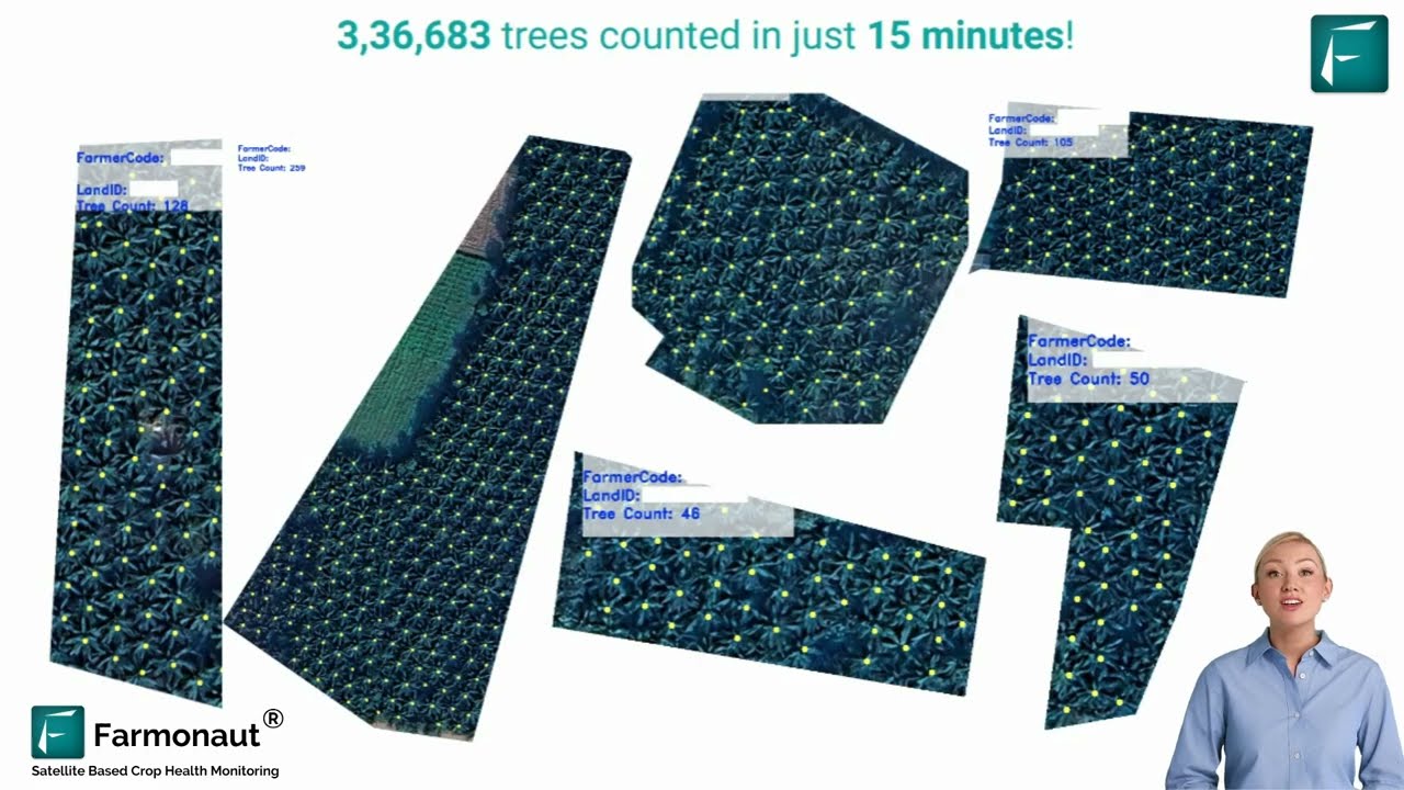
1. Remote Sensing & Geographic Information Systems (GIS) for Forest Management
Remote Sensing in Forestry: Indispensable Eyes in the Sky
Remote sensing technology—including satellites, aerial photography, and drones—has become indispensable for forest management and conservation (source).
With the ability to monitor vast, inaccessible forest areas, remote sensing provides detailed, timely data on vegetation cover, health, and change over time. Whether tracking regrowth post-fire, detecting illegal logging, or inventorying biomass, these technologies provide the foundation for data-driven forest operations.
GIS for Forest Management: Turning Data into Action
When remote data is integrated with a Geographic Information System (GIS), we unlock a powerful platform for spatial analysis, informed decision-making, and resource allocation. GIS for forest management allows us to map topography, soil types, canopy density, timber stocks, and even biodiversity hotspots, supporting site-specific and landscape-level planning.
- Monitor forest health, land use, and vegetation over time
- Detect signs of pest outbreaks, disease, or climate-driven disturbances early
- Prioritize conservation activities and restoration efforts in high-risk zones
- Integrate with other tech like LiDAR, drones, and AI systems for granular analysis
By fusing satellite, aerial, and ground-level data, remote sensing technology and GIS systems provide a holistic, geo-referenced understanding of our forests—empowering smarter, sustainable forestry operations and innovations.

2. Drones and UAVs: High-Tech Eyes for Forest Monitoring
Drones for Forest Monitoring: Data-Driven Aerial Perspective
Drones or Unmanned Aerial Vehicles (UAVs) have revolutionized how we monitor and manage forests.
Equipped with high-resolution cameras, multispectral sensors, and sometimes LiDAR payloads, these aerial vehicles can:
- Survey large tracts of forest swiftly and efficiently
- Measure tree height, canopy cover, biomass, and vegetation health
- Map site conditions, even in rugged or inaccessible terrain
- Detect storm, fire, or disease damage rapidly, supporting restoration planning
- Monitor reforestation progress, wildlife habitats, or illegal activities like logging
Drones for forest monitoring dramatically increase data collection efficiency, reducing labour and costs, while improving productivity—especially when integrated with advanced analysis tools and cloud-based reporting.
3. LiDAR: Forging the 3D Blueprint of Forest Ecosystems
LiDAR Forestry Applications: Precision Terrain and Vegetation Mapping
Light Detection and Ranging (LiDAR) is at the forefront of forest ecosystem mapping.
By firing laser pulses from aerial platforms and recording their reflections, LiDAR produces ultra-precise 3D models of vegetation structure, ground topography, and forest stand characteristics (source).
- Quantify tree height, crown spread, and forest density
- Create digital elevation and terrain models for land management
- Support road building, harvest planning, and erosion risk assessment
- Enhance forest inventory accuracy for carbon sequestration estimation
LiDAR forestry applications provide rich, actionable data for operators to design effective, sustainable management strategies.
“Remote sensing innovations have improved forest inventory accuracy by up to 30% since 2020.”
4. AI & Big Data Analytics: Unleashing Predictive Forest Management Technology
AI in Forestry Management: Powering Predictive Insights
Artificial Intelligence (AI) is rapidly transforming traditional forestry operations. By crunching massive datasets— from satellite observations to historical timber yields and real-time IoT sensor data—AI algorithms deliver actionable, predictive insights in forest management.
- Predict forest growth patterns and timber production under various scenarios
- Model carbon sequestration, climate impacts, and biodiversity trends
- Detect pest, disease, or fire outbreaks for targeted intervention
- Enable data-driven thinning, harvesting, and replanting operations
Big data analytics enables forest managers to shift from reactive to proactive, optimizing productivity and sustainability.
For example, predictive analysis helps plan resource allocation and optimize rotation age for maximizing both economic and ecological returns.
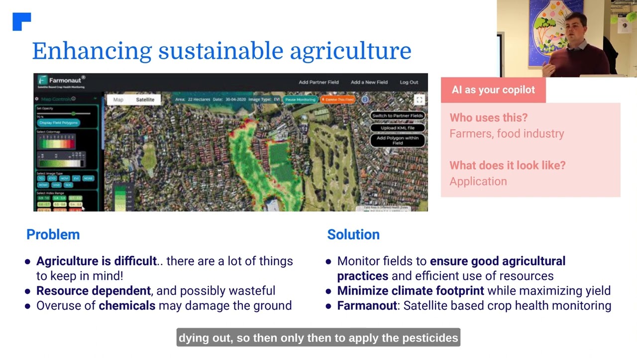
Farmonaut stands out for leveraging these capabilities through its AI-driven systems and satellite imagery platforms, offering real-time crop and forest health monitoring, carbon footprinting, and sustainability solutions to all stakeholders via web, mobile, and API access.
5. IoT: Building Smart Forests with Networks of Real-Time Sensors
IoT in Forestry: Sensors for Growth, Health, and Early Detection
The Internet of Things (IoT) connects a web of sensors across forest landscapes, delivering real-time data on environmental parameters such as:
- Soil moisture and temperature
- Tree-growth rates and physiological responses
- Microclimate changes, wind speed, and humidity
- Smoke or heat for early fire detection
This seamless integration of IoT devices empowers the creation of smart forests, enabling :
- Automated alerts for fire or flood risks
- Improved irrigation and nutrient management for agroforestry
- Granular analysis of carbon sequestration and environmental impact
Farmonaut supports this vision with affordable, scalable resource management tools, API integrations, and real-time insights for individual farmers, agribusinesses, and institutional users.
For developers and advanced operations, their API and Developer Docs make integrating satellite and sensor data frictionless.
6. Blockchain Timber Supply Chains: Ensuring Transparency, Sustainability, & Legal Compliance
Blockchain: Combating Illegal Logging & Promoting Supply Chain Integrity
Blockchain technology is gaining momentum in forestry, bringing traceability, transparency, and legality to the timber supply chain.
By recording each product movement—from harvesting through processing, transport, and final sale—on an unchangeable ledger, blockchain confirms the legality and sustainability of harvested timber and prevents greenwashing.
- Consumers and businesses can verify the origin, certification, and journey of timber products
- Authorities and NGOs can track illegal activity and safeguard biodiversity
- Boosts trust and premium pricing for sustainable forest products
Farmonaut’s product traceability solutions offer a cost-effective, blockchain-powered system for transparent supply chains—not just for agriculture and textiles, but highly relevant for timber and forestry-product authentication.

7. Precision Forestry: GPS & GIS Integration for Enhanced Forest Management
Precision Forestry GPS: Mapping, Planning and Impact Reduction
Precision forestry GPS and GIS integration enable forestry teams to manage natural resources with unmatched spatial accuracy.
With GPS-enabled field equipment and personnel tracking:
- Optimal routes for logging, thinning, and replanting operations are defined
- Environmental impact is minimized by avoiding sensitive habitats and biodiversity hotspots
- Site-specific reforestation and protection efforts can be planned with geospatial data layers
- Soil types, tree species, and terrain models are integrated into all operations
These innovations boost efficiency, reduce waste, and foster healthier forests for future generations.
GIS-based analytic platforms, as offered by advanced systems like Farmonaut, drive precision in forest health assessment, land allocation, and large-scale forest and farm management.
Comparative Feature & Impact Table: Forestry Technology Game-Changers 2024
| Technology Name | Core Function | Estimated Adoption Rate (2024, %) | Productivity Boost (%) | Environmental Impact | Implementation Difficulty |
|---|---|---|---|---|---|
| Remote Sensing & GIS | Large-scale forest monitoring Spatial analysis & mapping |
84% | 20-30% | + Biodiversity support, carbon monitoring | Medium |
| Drones/UAVs | Aerial survey, health monitoring, rapid assessment | 55% | 18-28% | + Reduced site disturbance | Medium |
| LiDAR | 3D terrain, stand, and biomass mapping | 37% | 15-25% | + Erosion, carbon stock estimation | High |
| AI & Big Data Analytics | Predictive decision-making & trend analysis | 29% | 24-35% | + Early pest/disease detection, adapt climate | Medium-High |
| IoT Smart Sensors | Real-time forest, weather & soil monitoring | 41% | 15-22% | + Fire detection, climate resilience | Medium |
| Blockchain Supply Chain | Transparent timber tracking & traceability | 22% | 8-11% | + Illegal logging prevention, consumer trust | Medium-High |
| Precision GPS & GIS | Accurate mapping, harvesting, operations | 68% | 20-32% | + Minimized impact, ecosystem-focused | Low-Medium |
Additional Sustainable Forestry Innovations Shaping 2024
Forestry Mulching: Efficient, Low-Impact Land Clearing
Forestry mulching uses advanced machinery to cut, grind, and clear vegetation in a single pass—directly on-site. This practice eliminates fuel-intensive steps like hauling debris, reduces emissions, and leaves nutrient-rich mulch on the soil, acting as an erosion barrier and improving site health for future tree growth.
Agroforestry Practices and Benefits
Agroforestry systems integrate trees, crops, and livestock on the same land, enhancing biodiversity, soil health, and productivity. Agroforestry provides timber, fruits, nuts, and fodder while reducing erosion, sequestering carbon, and building climate resilience.
Learn how crop plantation & forest advisory services, like those within Farmonaut’s ecosystem, leverage geospatial data to improve agroforestry implementation, monitoring, and yield optimization.
- Economic diversification and improved farm incomes
- Enhanced soil fertility, carbon fixation, and microclimate regulation
- Natural pest management and biodiversity support
Variable Retention Harvesting & Selection Cutting
Variable retention harvesting and selection cutting are ecological logging practices that enhance biodiversity by leaving clusters or individual mature trees standing after harvest, mimicking natural disturbances.
These methods support wildlife habitat, improve vertical forest structure, and maintain ecosystem health while allowing for continuous resource supply.
Precision Livestock Farming (PLF) in Agroforestry Contexts
PLF or Precision Livestock Farming is not exclusive to traditional animal husbandry—it’s increasingly applied within agroforestry systems.
Automated monitoring of animal movement, health, and environmental impact enables us to optimize livestock integration with forest lands, reducing overgrazing and improving sustainability.
Farmonaut: Affordable, Scalable Solutions for Forest and Farm Management Technology
As forestry practices evolve, embracing data-driven management tools is no longer optional—it’s essential for scalable, efficient, and sustainable operations.
Farmonaut leads this revolution with a comprehensive technology suite:
- Satellite-based crop & forest health monitoring—get NDVI, soil moisture, biomass, and growth analytics on-demand
- AI-driven advisories—receive real-time actionable insights with their Jeevn AI system, based on weather and vegetation data
- Blockchain traceability—ensure transparency and authenticity throughout agricultural and forestry supply chains
- Fleet and resource management—track vehicles, optimize operations, and reduce costs at scale (see Fleet Management)
- Carbon footprinting—monitor, reduce, and report emissions for sustainable certification (Carbon Footprinting Tool)
- Accessible via Android, iOS, web, and API for every user profile—from small farmers to large agribusiness or government bodies
Interested in unlocking cost-effective forest and farm management?
Try Farmonaut’s platform or download the app today.
FAQ: Forestry Technology, Remote Sensing & Forest Management
-
Q: What is remote sensing in forestry and why is it important?
A: Remote sensing uses satellite imagery, aerial photography, and UAV sensor data to monitor large forest areas for changes in canopy cover, health, vegetation, and threats like fire or pests. This technology is essential for real-time, cost-efficient, and accurate forestry management. -
Q: How does GIS help with sustainable forest management?
A: GIS allows us to layer, analyze, and visualize spatial data from the forest, enabling better planning, risk assessment, resource allocation, and biodiversity conservation. -
Q: What are the best forestry management technologies to adopt in 2024?
A: Key game-changers include remote sensing & GIS, drones/UAVs for aerial monitoring, LiDAR mapping, AI and big data analytics, IoT sensors for real-time data, blockchain for transparency, and precision forestry GPS. -
Q: How do AI and big data analytics impact forest health monitoring?
A: AI systems analyze trends, predict risks, and guide proactive, evidence-based forest management, from pest/disease control to climate adaptation strategies. -
Q: Can blockchain help prevent illegal logging?
A: Yes, blockchain enables transparent, tamper-proof timber supply chain tracking, which helps authorities and buyers verify that timber originates from legal and sustainable sources. -
Q: How do I access Farmonaut’s forestry and agricultural management solutions?
A: Farmonaut’s tools are available via web and app, and for advanced integrations through their API platform. -
Q: Is Farmonaut suitable for both small-scale farmers and large organizations?
A: Yes, their modular, scalable system supports everyone from individual farmers to cooperatives, agribusinesses, governments, and corporate clients. -
Q: What is the role of IoT in creating smart forests?
A: IoT interconnects environmental sensors across landscapes, delivering real-time intelligence on temperature, moisture, growth, fire risks, and more for faster response and smarter resource use.
Conclusion: Technology-Driven Forestry for a Sustainable Future
The 2024 landscape for forestry technology is vibrant, accessible, and transformative.
By leveraging innovations in remote sensing, GIS, drones, LiDAR, AI, IoT, and blockchain, we as forestry professionals, land managers, and policymakers stand to drive a new era of sustainable forest management.
These tools help us tackle mounting biodiversity loss, climate threats, and resource optimization challenges—ensuring a balanced relationship between economic, environmental, and social priorities.
As adoption climbs and implementation hurdles diminish, now is the best time to invest in smarter systems, precision forestry upgrades, and transparent supply chain management.
For those seeking a cost-effective, scalable platform for modern forest operations, Farmonaut is ready to empower your journey.
Embrace advanced monitoring, proactive management, and data-driven decision making—so our forests, and all who depend on them, flourish for generations to come.


